A large-scale pattern shift will continue to facilitate warm and dry weather for the Front Range through much of the week. Things get messy just in time for the weekend, however. We’re tracking a storm that will bring much colder temperatures, lots of rain, and higher elevation snow.
A warm week ahead
The weather pattern shifts towards boring this week. As we touched on in our outlook for the month of May, the main weather player for the upcoming week will be a dominant ridge of high pressure. This ridge will keep unseasonably warm and generally dry air across much the southern Rockies through Friday morning. The animation below from the GFS shows 500 mb height anomaly through the week. Notice the abundance of orange across not only Colorado, but most of the United States. Orange indicates anomalously high heights.
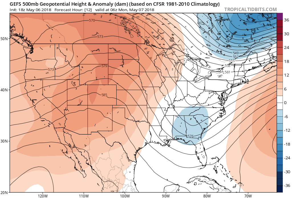
GFS 500 mb height anomaly forecast animation through Friday evening.
This ridgy pattern will lead to warm temperatures for us. The forecast map below shows the 5-day temperature anomaly from the GFS ensembles for the week. Lots of warmth is evident across the United States. This is especially true for eastern Colorado where we’ll be about 15°F warmer than average through the week. Temperatures will range from the upper 70’s to middle 80’s for the Metro area.
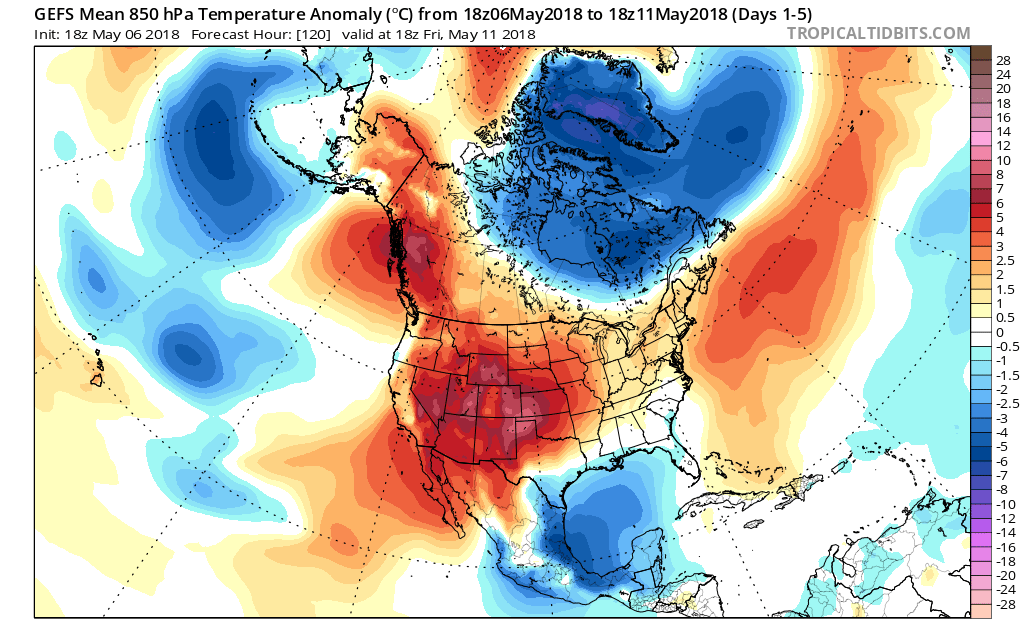
GFS ensemble 5-day temperature anomaly forecast, covering Monday through Friday this week.
Any chance for rain will be small and be embodied in just a few isolated afternoon thundershowers. The only day we are concerned about this happening is Thursday. Monday through Wednesday will be dry.
Changes for the weekend
As is so often the case, a beautiful work week turns ugly just in time for the weekend! That appears to be the direction our weather is heading this week. Similar to the very wet storm system we saw last Wednesday and Thursday, yet another cut-off low will likely impact our region over the upcoming weekend. The 500 mb vorticity map below shows the position of the storm Friday night across northern Utah.
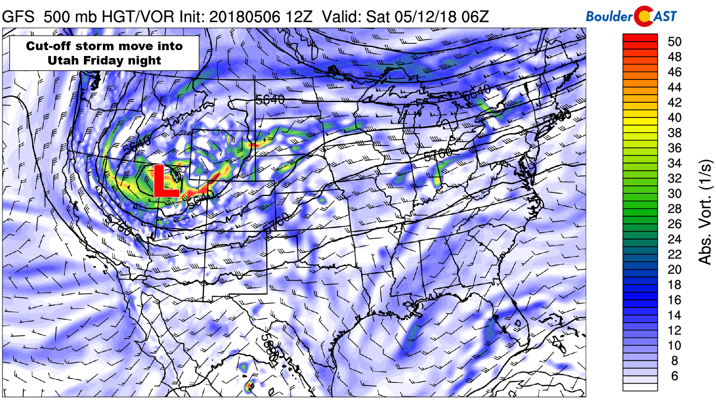
GFS 500 mb vorticity map for Friday night. A small, but potent storm will be located across Utah.
There is good agreement in both the GFS and European ensembles for this feature, so our confidence is rather high despite being four days away.
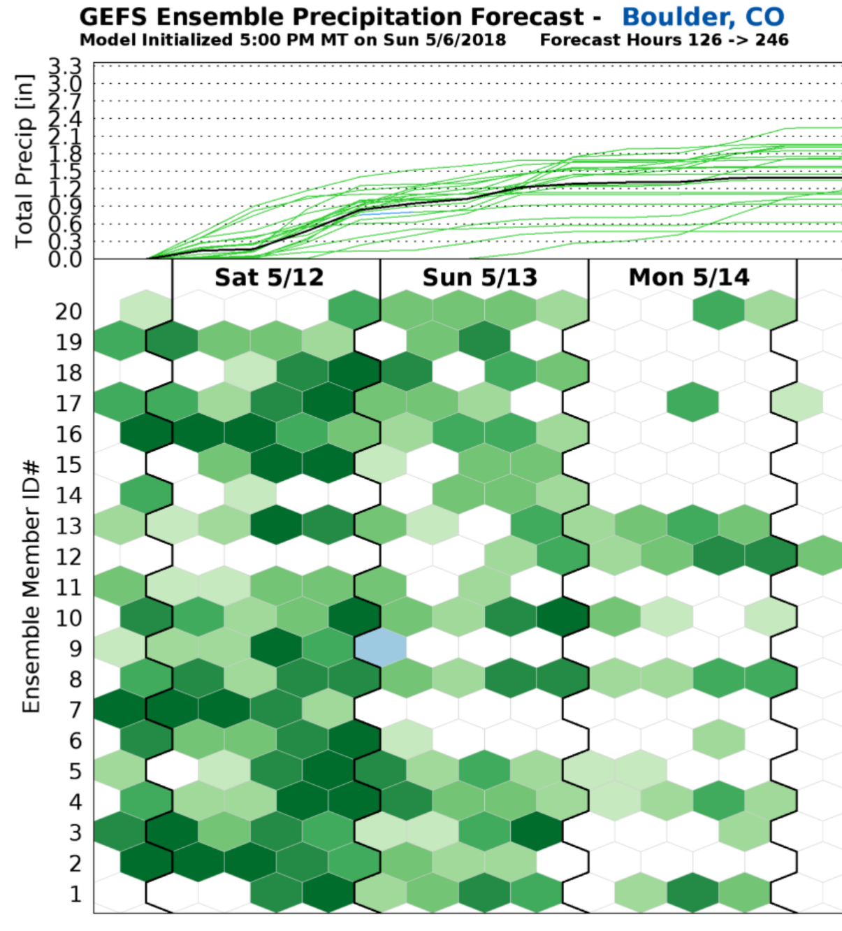
GFS ensemble precipitation plumes for the weekend. The median is 1.59″ in Boulder.
Models generally agree the storm will stall and slowly die across Utah or western Colorado over the weekend. In the process, it will propel significant moisture and energy into both Colorado and Wyoming. Time will tell exactly how much precipitation we see, but there is indication that this could be another 1 to 2″ precipitation event for the Front Range, with cold enough air for some snow in the Foothills and possibly even across the Plains. For now, plan on a much cooler and wetter weekend across the Front Range.
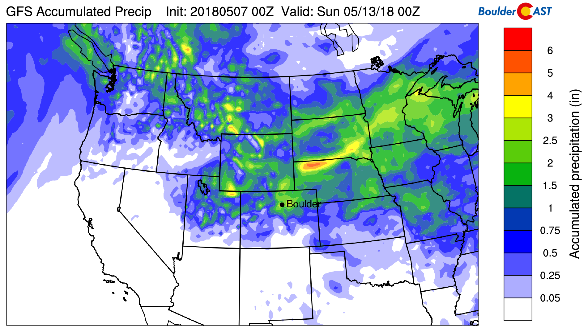
GFS total accumulated precipitation forecast through Saturday evening. Significant precipitation is indicated for northeast Colorado Friday into Sunday.
Friday should be a day of transition. Depending on how the storm tracks this week, Friday’s potential weather is quite uncertain. Expect a good deal of clouds and also elevated chances of rain showers during the afternoon and evening. Highs will drop into the 60’s or lower 70’s. If the weekend storm pans out as expected, temperatures Saturday could remain in the 50’s for the lower elevations, with heavy snow possible in the Mountains. We’ll need to see how the models trend for temperatures through the week…this will determine how far down snow levels drop for the storm and the potential wintry impacts for the Metro area.
More than likely we’ll have a storm update or two later this week. Until then, feel free to relish the warmth that lies ahead…
Forecast Specifics:
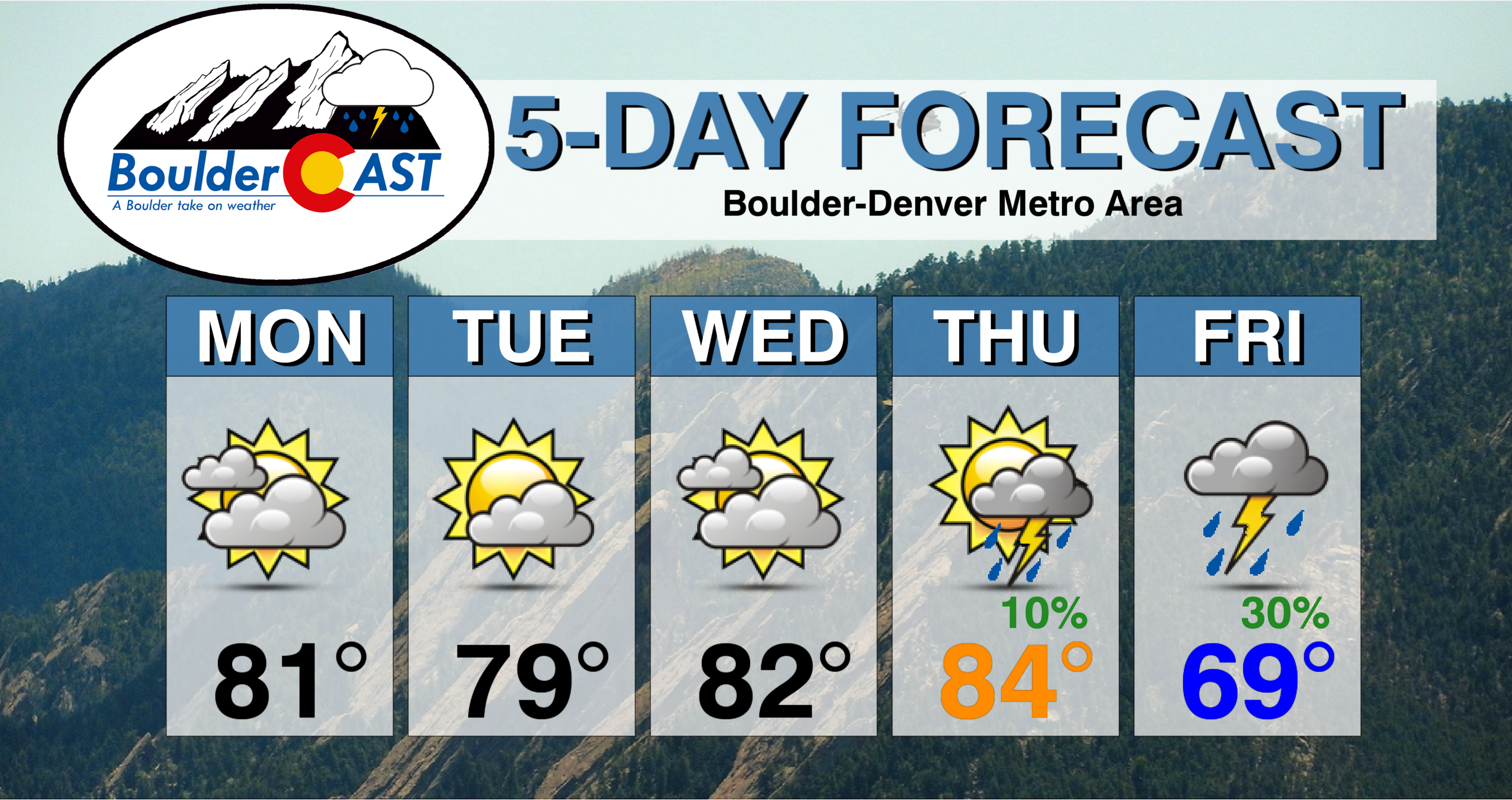
Monday: Mostly cloudy and warm. Highs over the Plains in the lower 80’s with upper 60’s in the Foothills.
Tuesday: Partly cloudy and quiet. Highs near 80 degrees on the Plains and upper 60’s in the Foothills.
Wednesday: Morning sunshine, with lots of high clouds filling the skies by early afternoon. Temperatures in the lower 80’s for the Plains and upper 60’s in the Foothills.
Thursday: The warmest day of the week. Partly cloudy with isolated afternoon thunderstorms. Some storms east of Denver could approach severe level given the atmospheric set-up. Highs in the middle 80’s on the Plains and upper 60’s in the Foothills.
Friday: Mostly cloudy with a chance of thunderstorms in the afternoon and evening. The chance of rain will depend on the track/timing of the weekend storm system. Expect highs to be cooler, probably in the upper 60’s to lower 70’s for the Plains with upper 50’s in the Foothills.
Weekend: With a potent storm system arriving Friday night, the weekend will turn much cooler and wetter for the region. Rain is expected to fall Friday night and through the day Saturday, possibly lingering into Sunday. Heavy snow will fall across Colorado’s northern Mountains, with the potential for some accumulation in the Foothills as well.
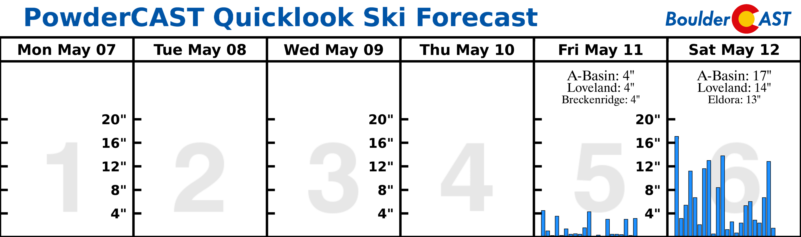
High Country: Mountain weather this week will be dominated by the upper-level ridge with dry weather and temperatures above normal through Wednesday. Isolated thundershowers are possible Thursday afternoon north of Interstate 70, with a better chance of rain/snow Friday and into the weekend. Models are showing the potential for heavy snow Saturday into Sunday, but there is still too much uncertainty to pin down specifics this far out. Find the latest forecast for all your favorite Colorado ski resorts on our PowderCAST page.
DISCLAIMER: This weekly outlook forecast was created Monday morning and covers the entire upcoming week. Accuracy will decrease as the week progresses as this post is NOT updated. To receive daily updated forecasts, subscribe to BoulderCAST Premium.

.
Share our forecast!
.


You must be logged in to post a comment.