
Much warmer and sunnier weather is expected this week. No major storm systems will be impacting the state of Colorado. However, thanks to elevated moisture, there will be a daily chance of afternoon and evening thundershowers early in the week.
Hail and heavy rain recap
Last week’s slow-moving storm did not disappoint across the Boulder area! Thunderstorms last Friday afternoon produced up to 3″ of rain in parts of Boulder County, prompting Flash Flood Warnings to be issued for the city of Boulder. Any actual flooding seems to have been brief and mainly just minor street flooding. On the eastern fringe of the city into Superior, dime to nickel sized hail fell for nearly an hour. Some areas saw hail accumulate up to 8 inches deep!
Video of accumulating hail on US-36 heading into Boulder – Friday May 18, 2018
(Credit: Jenny B of Boulder)
The second half of the event did not fully pan out as forecast, with the center of the low developing further north and east than expected. This resulted in less overall precipitation across the Denver Metro area on Saturday, though the weather was still rather ugly….with low clouds, fog, mist, and rain showers at times.
The radar image below from Saturday morning shows the impressive, barely-moving precipitation shield with the storm. Because there was so much moisture available, it ended-up looking a little bit like a tropical storm, don’t you think? Notice how Denver/Boulder we’re just a tad too far southwest. Nonetheless, on-and-off showers continued through much of the day Saturday.
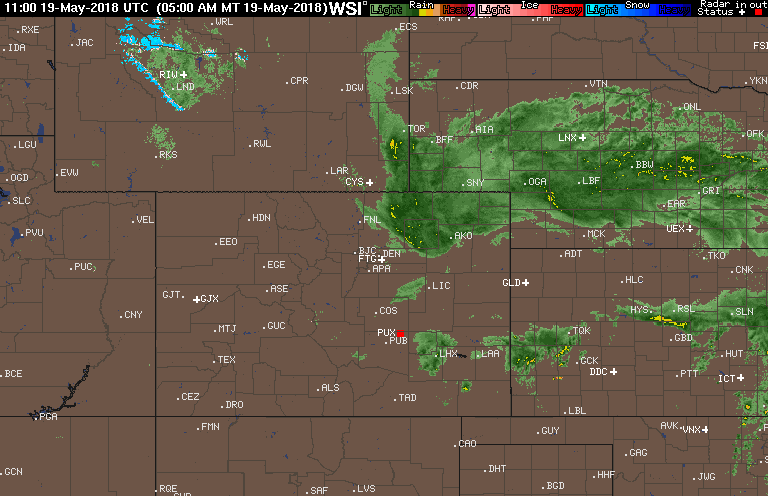
Radar animation as of 7 AM on Saturday morning (May 19, 2018).
Rain totals for the two-day event were mainly in the 0.5″ to 1.5″ range for the Denver Metro area. However, east Boulder saw more than 3″ due to those slow-moving thunderstorms on Friday afternoon. The official totals were 0.90″ in Boulder and 0.13″ in Denver.
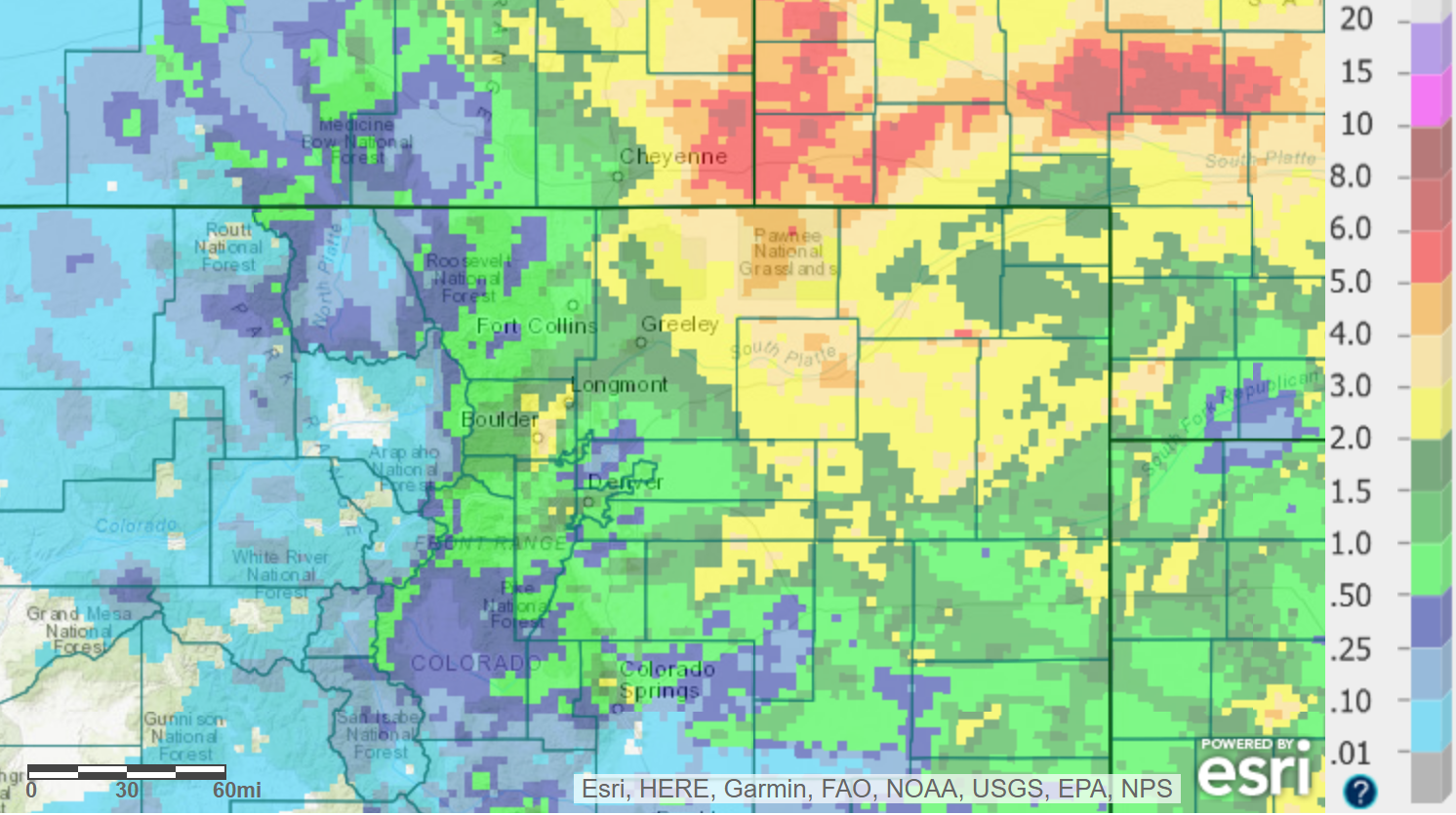
Rain totals from May 18-19, 2018 across northeast Colorado.
The week ahead
Similar to the weather we have seen throughout the month of May, another slow-moving low pressure system will be impacting the western United States this week. However, unlike the prior storms, this one will stay further away from Colorado and have only indirect impacts to our region through the week.
The GFS 500 mb vorticity map below shows the storm’s position on this lovely Monday morning…located across central California.
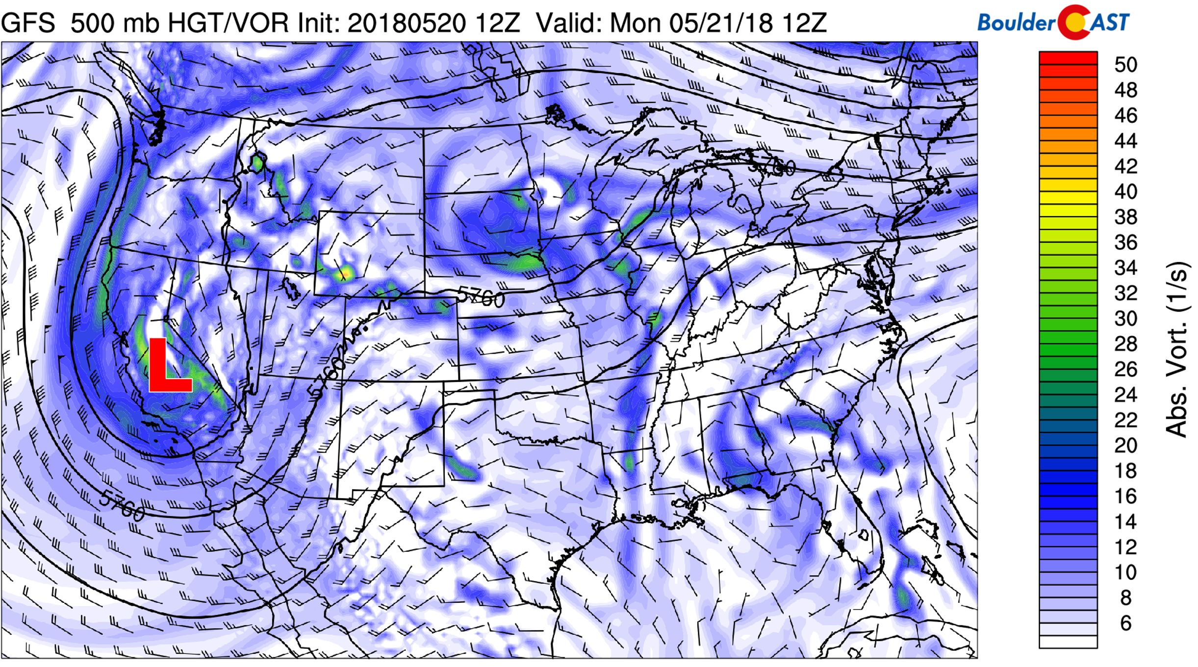
GFS 500 mb vorticity map for Monday morning. The position of the storm system is seen across California, with southwest flow into Colorado.
Afternoon showers and thunderstorms will be possible again Monday through Wednesday thanks to moisture seeping into Colorado from the south. However, if you notice in the map above, there is slight ridging across Colorado, stretching northward from Texas. This will ultimately keep the chances fairly low. Temperatures Monday through Wednesday will be in the upper 70’s to lower 80’s.
Towards the end of the week, the low pressure system will have moved into the far northern Plains, with more expansive ridging beginning to build across the Rockies on Friday. Drier west or northwest flow will enter the picture late in the week. This should lower chances of storms Thursday and Friday. Given the stable airmass, we think Thursday and Friday will be dry region-wide. Temperatures will also bump up these days with ample sunshine…probably in the mid to upper 80’s to close out the week.
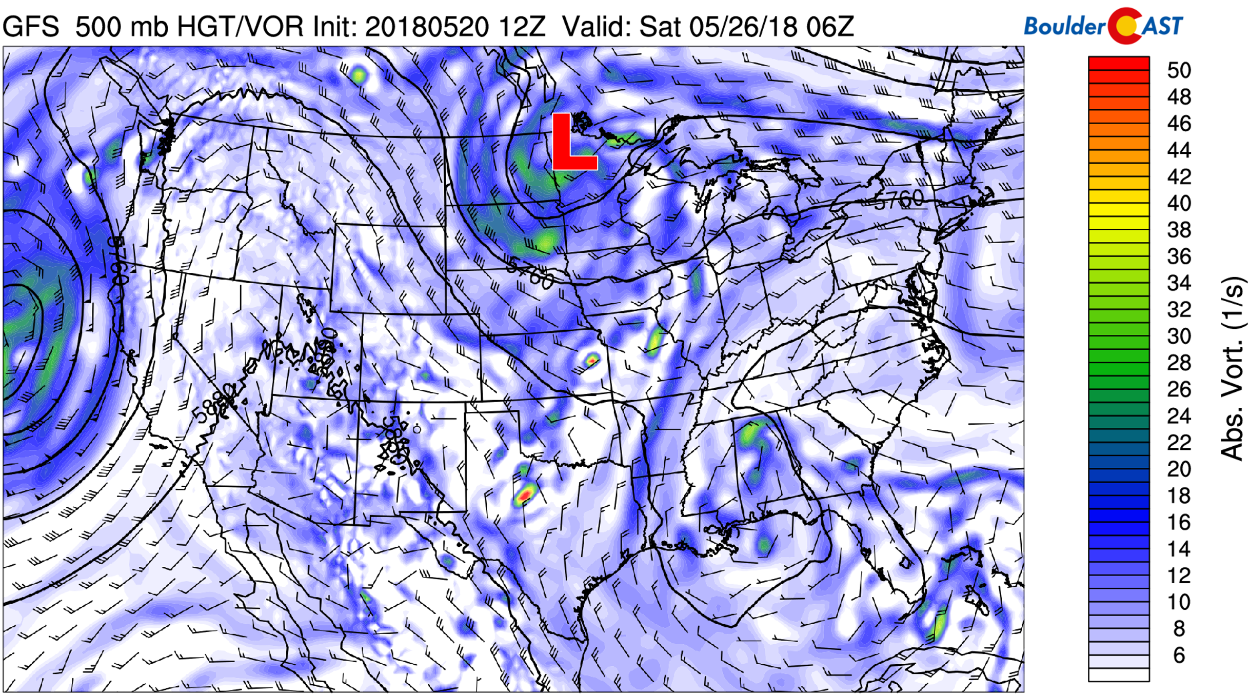
GFS 500 mb vorticity map for Friday evening. A large ridge builds across the West.
All indication in the models points to the slight chance of afternoon storms returning to the forecast for the upcoming holiday weekend, especially across the higher elevations. It looks like this year will turn out better than last year’s rain/severe weather! Look for our forecast update covering Memorial Day Weekend later in the week…
Forecast Specifics:
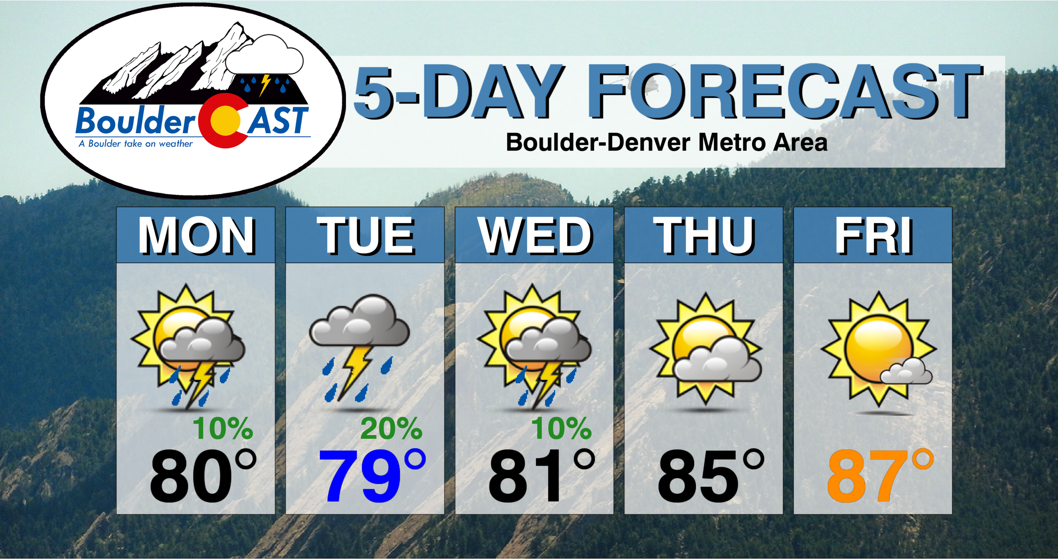
Monday: Partly cloudy with isolated afternoon and evening thunderstorms, mainly south of Interstate 70. Highs near 80 degrees across the Plains and in the upper 60’s in the Foothills.
Tuesday: Mostly cloudy with isolated afternoon and evening thunderstorms. Highs near 80 degrees on the Plains and mid 60’s in the Foothills.
Wednesday: Morning sun with increasing clouds and chances for isolated showers and thunderstorms in the late afternoon and evening, mainly across the higher elevations. Temperatures warmer in the low 80’s for the Plains and upper 60’s in the Foothills.
Thursday: Morning sun with skies turning partly cloudy in the afternoon. Highs in the mid 80’s on the Plains and low 70’s in the Foothills.
Friday: Mostly sunny and warm. Expect highs in the mid to upper 80’s for the Plains and in the low 70’s in the Foothills.
High Country: With not a lot of organization in the weather pattern, this week will see mainly diurnal convective activity across the Mountains. This means spotty afternoon and evening thunderstorms each day early this week. The most active afternoons look to Monday and Tuesday. Thursday and Friday will be mainly dry. If your are planning to do any hiking, be sure to check out our SummitCAST page for the latest forecasts.
DISCLAIMER: This weekly outlook forecast was created Monday morning and covers the entire upcoming week. Accuracy will decrease as the week progresses as this post is NOT updated. To receive daily updated forecasts, subscribe to BoulderCAST Premium.

.
Share our forecast!
.


You must be logged in to post a comment.