A favorable atmospheric set-up will help to funnel the remnants of Hurricane Bud, currently churning off the coast of western Mexico, into Colorado over the upcoming weekend. We discuss the impacts this will have for the Front Range and the rest of the state.
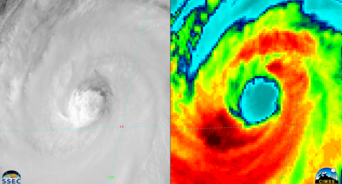
Despite being a potent Category 4 hurricane just 24 hours ago, Hurricane Bud has now weakened to tropical storm status. The GOES-East water vapor animation below captured Bud at his strongest yesterday during the daytime (bottom left corner). However, it is clear towards the end of the loop that Bud experienced rapid weakening, with the eye of the storm collapsing and convection ceasing on the northeast quadrant.
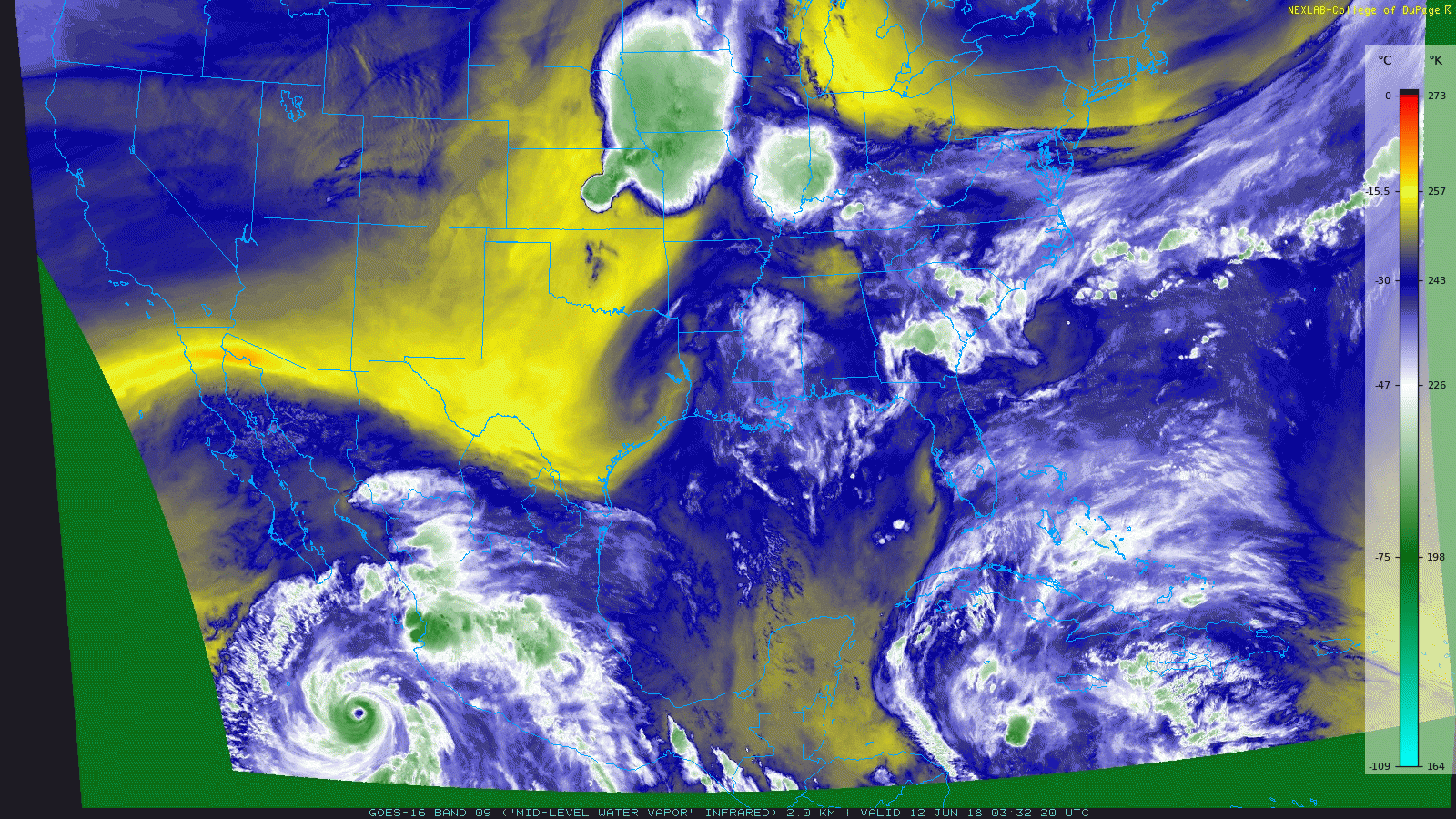
GOES-East mid-level water vapor animation during the day Tuesday (June 12, 2018). The storm strengthened to Category 4 status but weakens towards the end of the animation.
The swift weakening was due to the storm moving over cooler ocean waters. The “quick-and-dirty” threshold of sea-surface temperature for hurricanes to form and maintain their strength is 80°F (26.5°C). The map below of recent sea-surface temperatures off the Mexican coastline shows Bud crossing the critical 26.5°C line. Tropical Storm Bud will continue through cooler waters until making landfall near Cabo San Lucas, Mexico as a weak tropical storm Thursday evening.
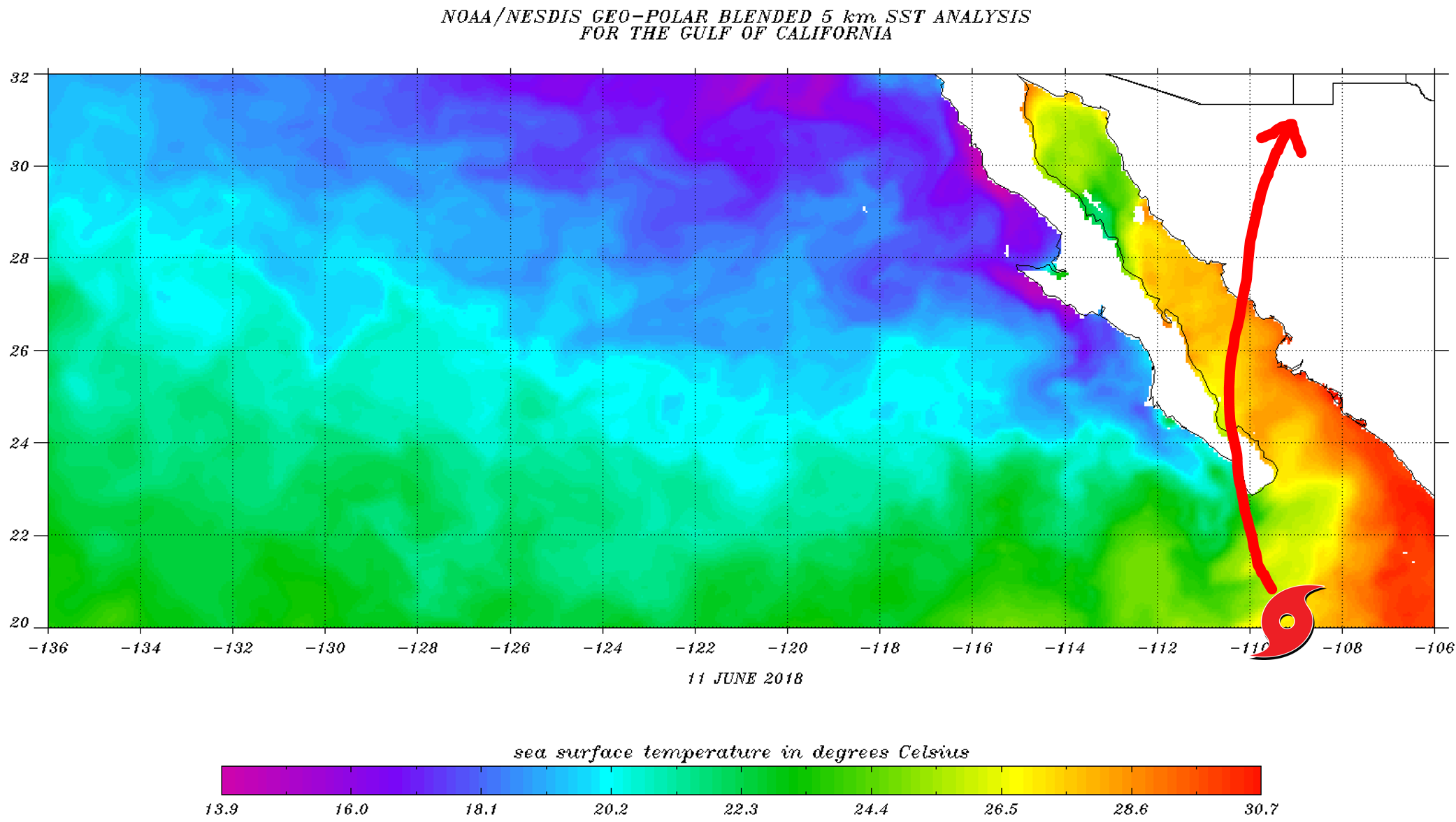
Sea-surface temperature analysis from June 11, 2018 off the coast of western Mexico. Hurricane Bud moved into cooler waters and will continue to weaken.
Post-landfall, the large-scale atmospheric set-up is such that the remnants of Bud will move into the Four Corners region over the weekend. Not many tropical cyclones in the eastern Pacific are able to curl back northeastward into the southwestern United States. It’s a bit of good fortune that led to this track actually….the combination of (1) a deep trough along the West Coast and (2) pesky high pressure that has been “packing the heat” for two weeks now located over Texas. The resulting steering winds will bring Bud directly into Colorado in due time.
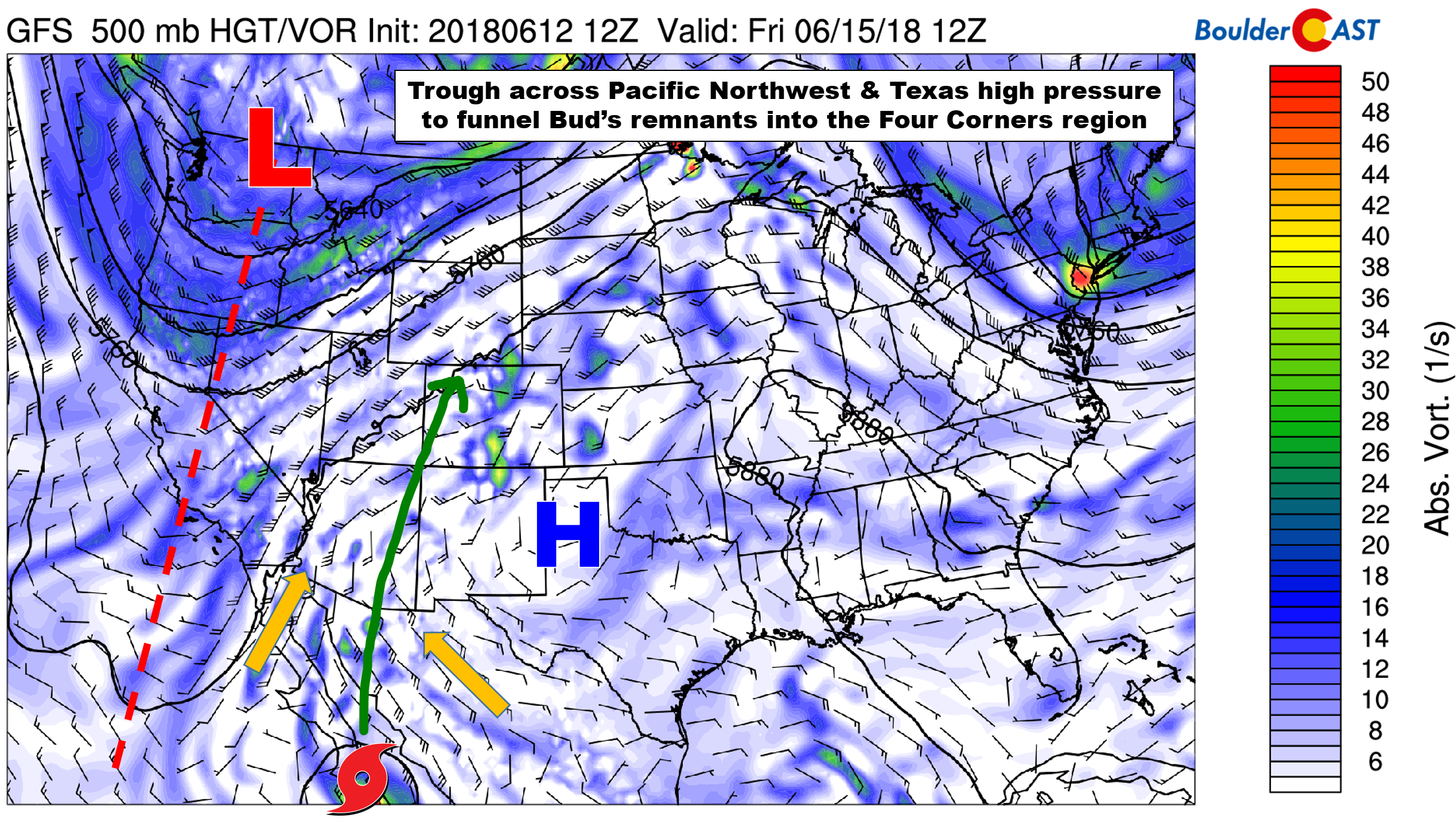
GFS 500 mb vorticity map for Friday morning showing Tropical Storm Bud and the large-scale atmospheric factors affecting Bud’s track.
Of course, we are not worried about typical tropical cyclone impacts here in Colorado! By the time the remnants of Bud reach our region this weekend, the circulation will be extremely disorganized and definitely unrecognizable as a former Category 4 hurricane. Instead, Bud will carry along a pool of air deeply enriched with tropical moisture. The latest GFS forecast for moisture anomaly below shows the surge of moisture associated with the expired tropical cyclone, moving through Arizona and New Mexico into Utah and Colorado. We could be looking at precipitable water values exceeding 1.25″ on Saturday in Denver, nearing all-time record levels for the month of June.
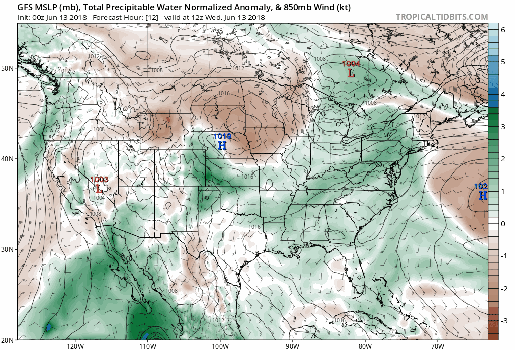
GFS pressure and moisture anomaly forecast animation for today through Monday.
Three days out, it appears the best moisture and precipitation will remain west of the Continental Divide in Colorado. Due to the extreme moisture availability, there could be localized flooding, especially Saturday afternoon and evening across the Western Slope. We expect the National Weather Service will be issuing a Flash Flood Watch for portions of the Four Corners region.
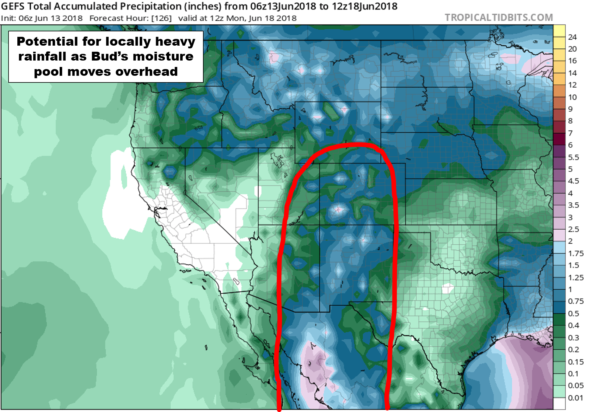
GFS ensemble mean forecast total precipitation through Monday morning.
The 416 Fire near Durango, which currently is just 15% contained with 24,000+ acres burned, will see relief from Mother Nature this weekend….not only in terms of beneficial rainfall, but also cloud cover, cooler temperatures, and higher relative humidities.
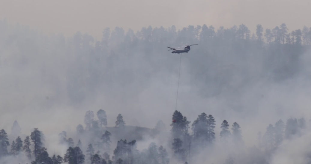
416 Fire on June 9, 2018 near Durango, CO.
The 416 Fire is just one of many massive fires burning across the southwestern United States and northwestern Mexico right now. Models forecasts have smoke levels intensifying across Colorado over the next few days before Bud’s remnants finally arrive. Expect decreased visibility and poor air quality over the coming days in the Metro area.
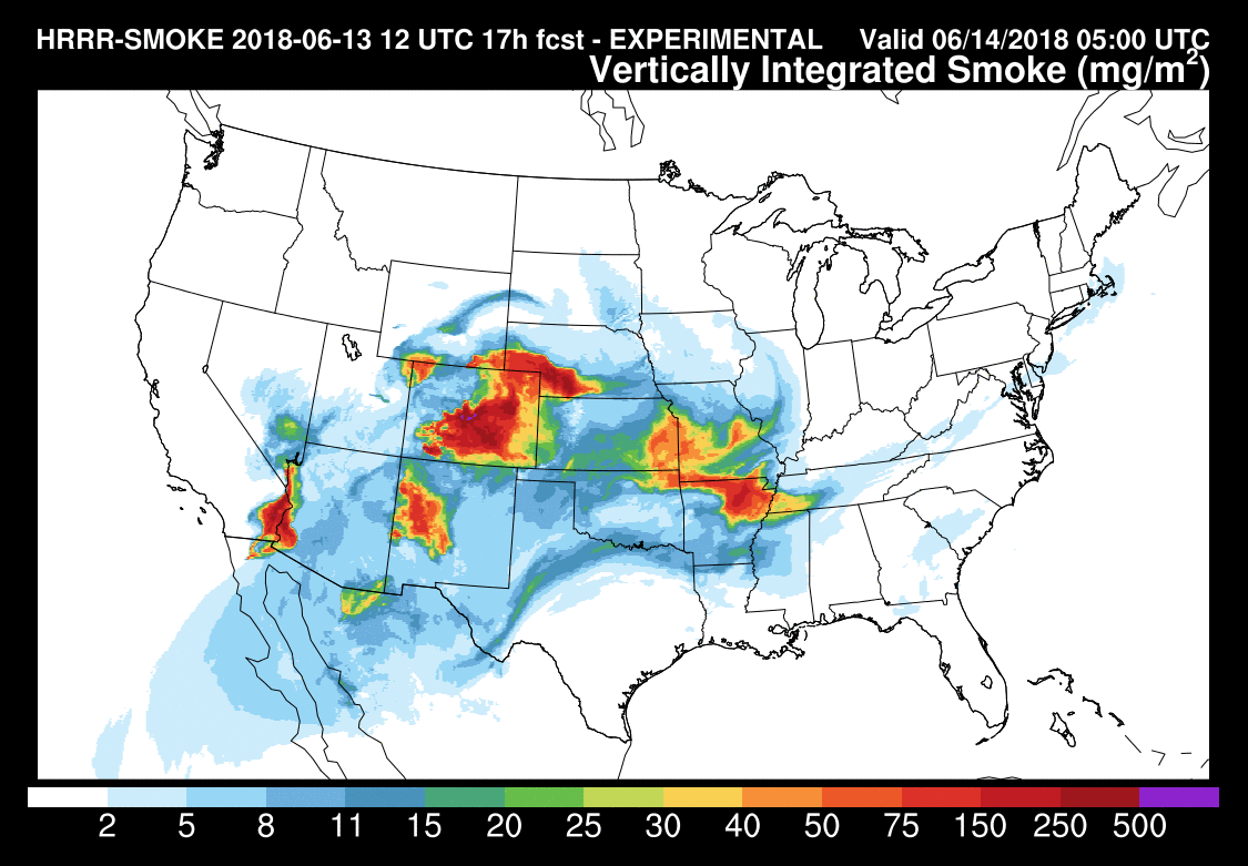
HRRR model integrated smoke forecast for Wednesday evening.
1 to 2″ of rain is anticipated across parts of central and southwestern Colorado this weekend. Localized areas could see more than 3″ along with isolated terrain-enhanced flash flooding.
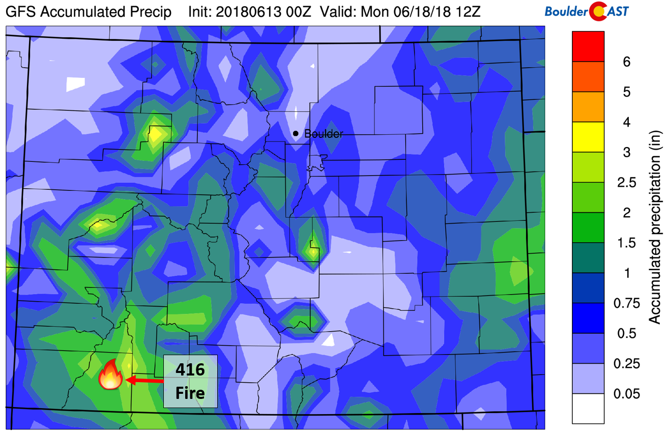
GFS total precipitation forecast through Sunday, with the position of the 416 fire shown.
Any and all rain is welcomed across the fire-ravaged and drought-stricken Desert Southwest right now…even with the associated flood risks…
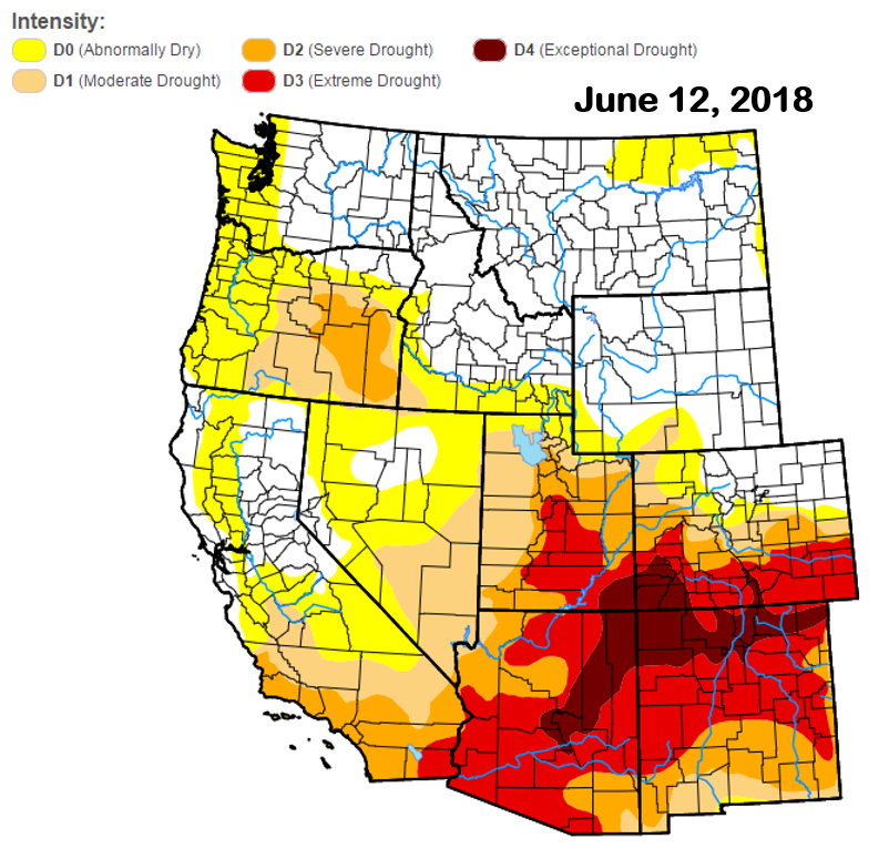
Current drought status across the western United States as of June 12, 2018 (Source: U.S. Drought Monitor).
What does this all mean for the Front Range? Though we won’t be directly in the line of fire of Bud’s remnants, we should still benefit from the elevated moisture with increased chances for storms beginning Friday and continuing through the weekend into early next week. In our heat-wave update six days ago, we described how well-established and hot the airmass in place across Colorado is….and that it would take a significant weather system or pattern change to oust it from our region. The combination of Bud’s remnants and the West Coast trough will indeed do the trick. All the clouds and precipitation, in tandem with a stronger cold front arriving Sunday or Sunday night, will bring cooler and more unsettled weather to our region early next week. We’re talking 70’s for afternoon highs with fairly good chances of rain for once. This is great news considering that neither Boulder nor Denver has seen measurable precipitation since May 30th!
If you plan to head to the High Country this weekend, expect a rather wet go. Sunday will be the drier day overall, but storm chances during the afternoon will still be sizable. Visit SummitCAST for our latest mountain forecasts.
Keep your fingers crossed that Bud delivers the goods for the areas that need it most this weekend!
Forecast specifics:
Wednesday: Morning sunshine with partly cloudy skies in the afternoon. Smoke will be present through the day. A few isolated thunderstorms will be possible in the early evening, mainly south and east of Denver. Highs near 90 degrees.
Thursday: A mix of clouds and sun with smoke. It will be hot with highs in the low to middle 90’s. Isolated thunderstorms will again be possible in the late afternoon and early evening, primarily south and east of Denver.
Friday: Partly to mostly cloudy and hot with smoke. Highs will be near 90 degrees. Widely scattered showers and storms are expected during the afternoon and evening.
Saturday: Overcast with scattered afternoon and evening thunderstorms. More widespread rainfall is likely west of the Continental Divide, with localized flooding possible. Highs will be in the mid to upper 80’s.
Sunday: Morning sunshine with increasing clouds. Scattered afternoon and evening thunderstorms are probable with temperatures topping out near 80 degrees.
Early Next Week: A series of cold fronts and residual moisture from Bud will lead to temperatures in the 70’s to begin the week with good chances for afternoon and evening thunderstorms each day.
Share this forecast:
.


You must be logged in to post a comment.