



Summer 2026 is beginning to wrap-up, but before we close the books on one of Colorado’s most punishing warm‑season patterns in recent memory, we’re taking you through the full story — from the record‑warm, snow‑starved winter that set the stage, to the monsoon that never quite cohered leaving fuels critically dry statewide, to the heat dome that kept both day and night historically warm.
Read on as we break down why Boulder’s rainfall never materialized this summer, why Denver fared only marginally better, how nearly 250,000 acres burned statewide, and why half of Colorado is now in Extreme or Exceptional Drought. This summer has certainly been one for the record books, in more than one way.
What You Need to Know
- 🌡️ Record‑warm winter & spring — Colorado entered summer with abysmal snowpack and its worst drought since the Marshall Fire period.
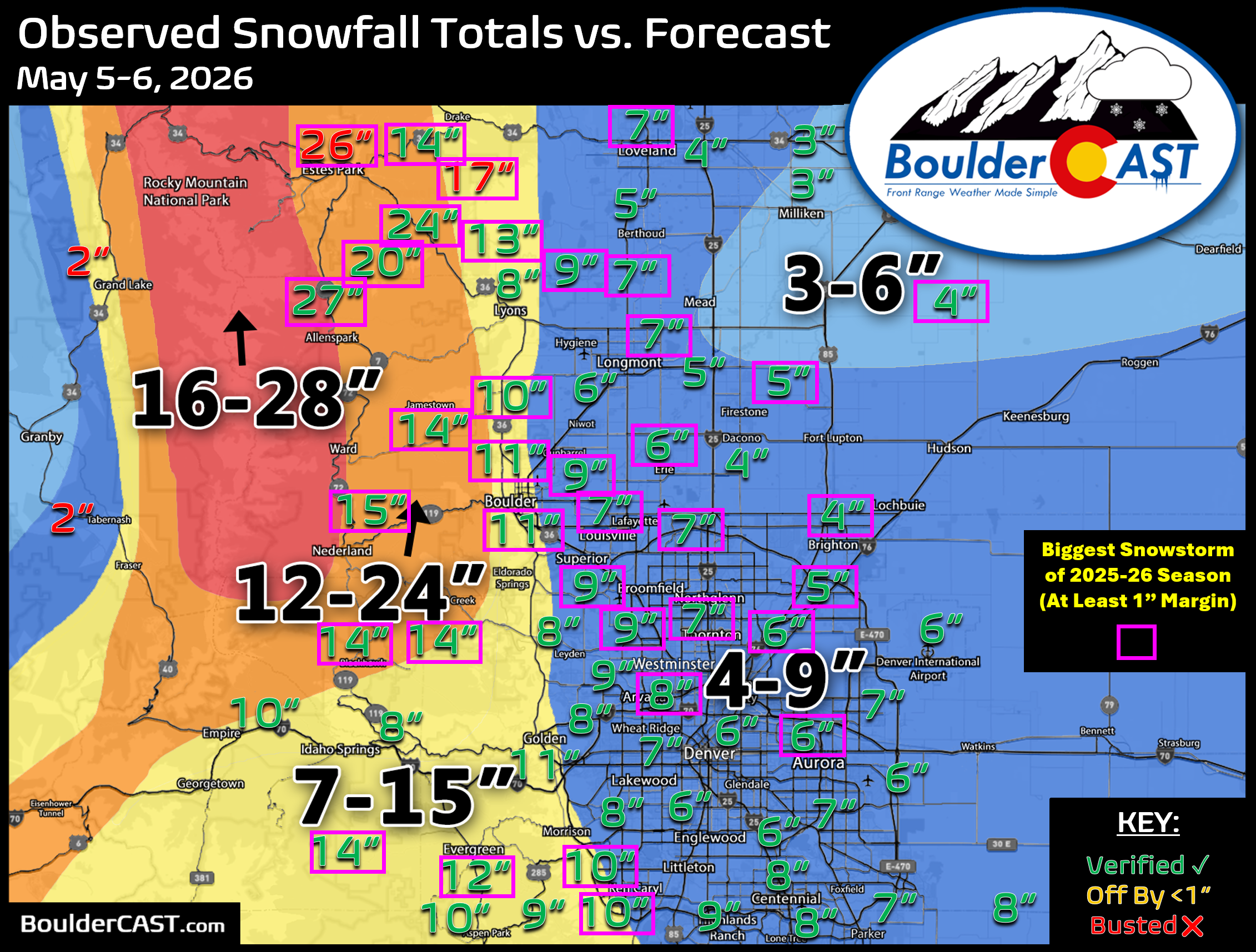
- ❄️ May storms offered limited relief — Two major systems, including a damaging late‑season snowstorm, briefly improved drought but didn’t meaningfully shift long‑term moisture deficits.
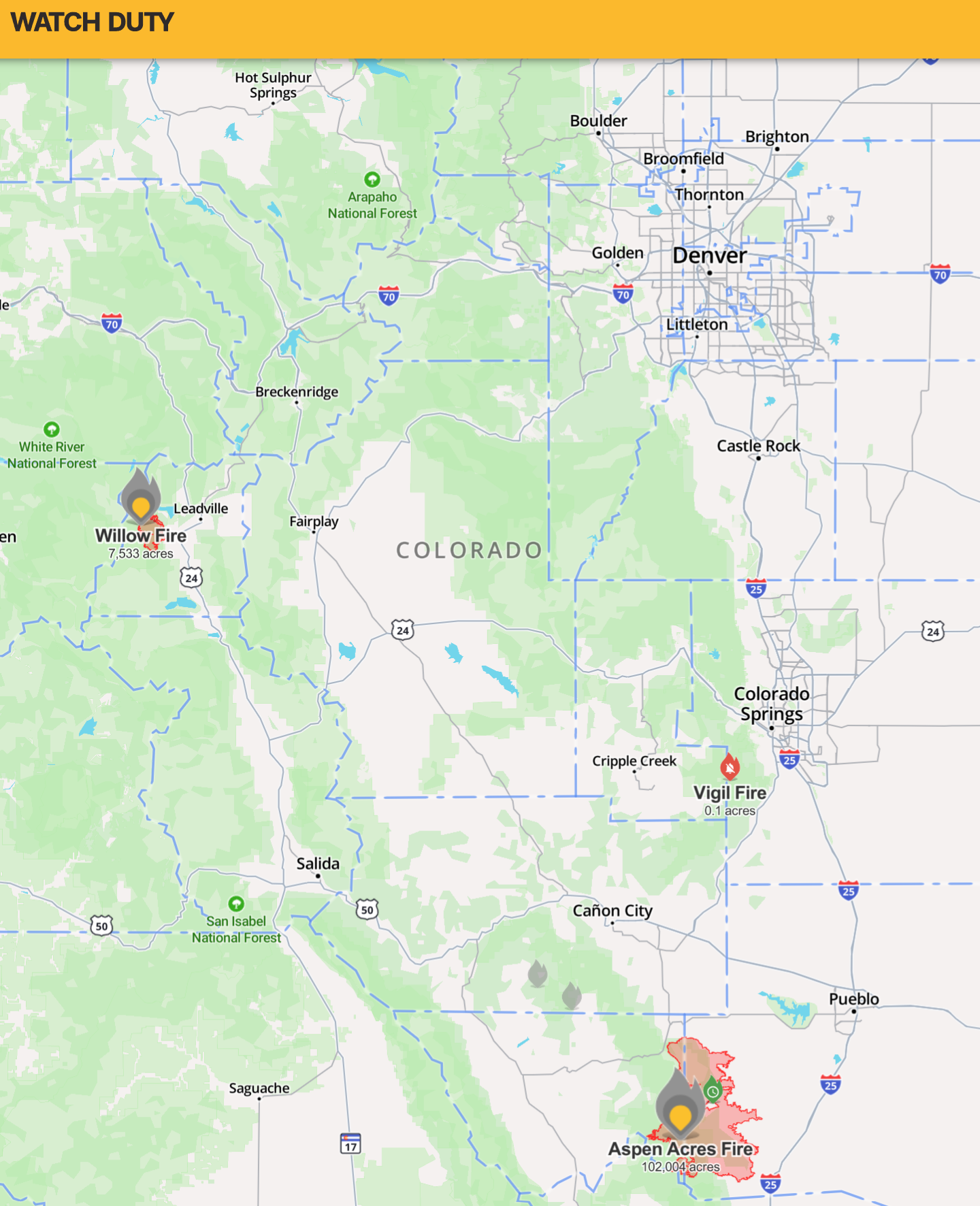
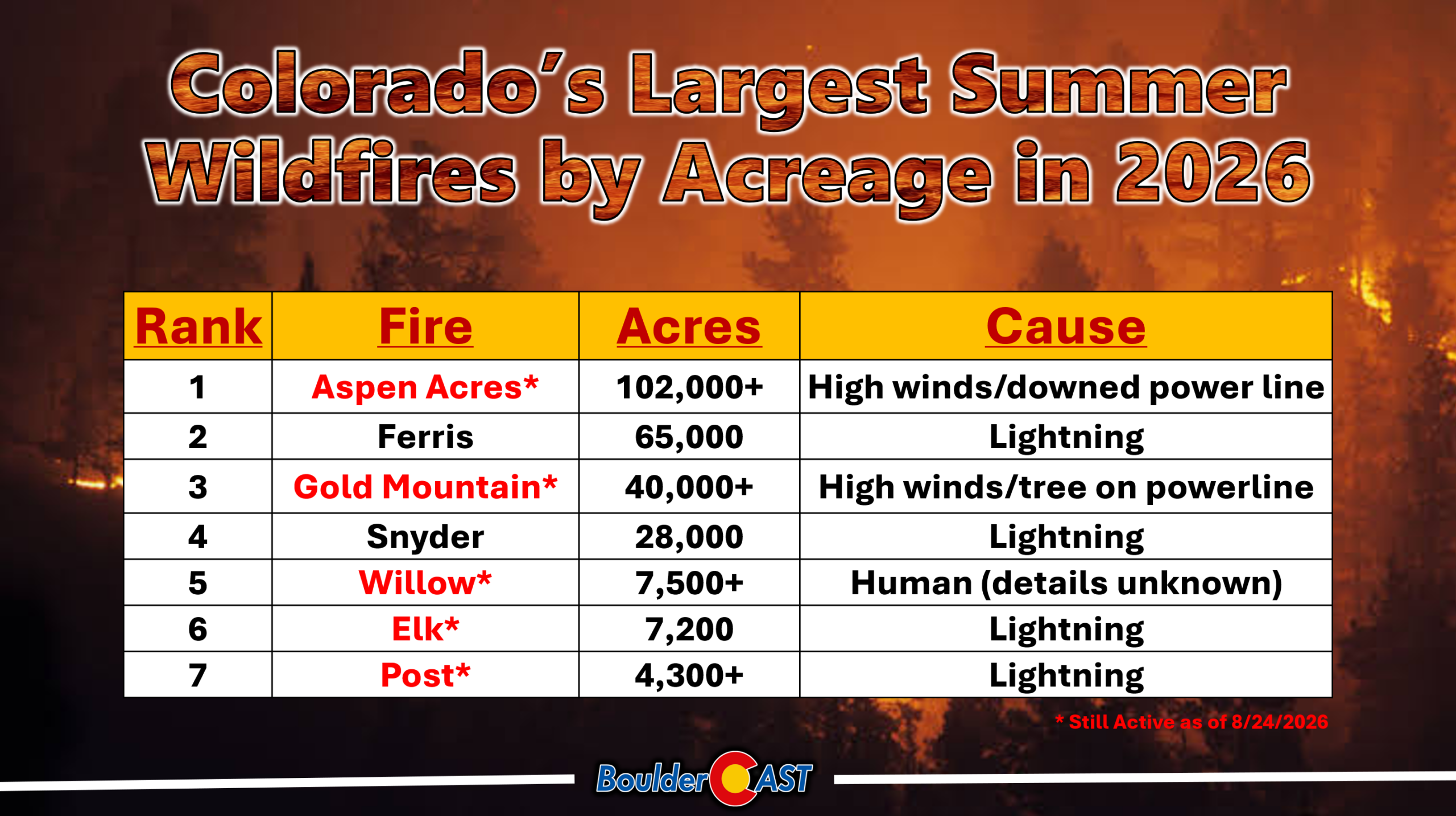
- 🔥 Early‑season fire outbreak — Dry lightning during El Niño’s onset triggered several major Four Corners fires, including the massive Aspen Acres Fire that burned 100,000+ acres and remains not fully contained.
- 🌀 Stagnant high pressure dominated — A persistent heat dome displaced monsoon moisture westward, suppressing convection and leaving most of Colorado with <50% of normal rainfall this summer.
- 🌧️ Front Range rainfall disparity — Boulder logged 31 “rainy days” but only 1.43″ of rain, while Denver saw fewer rain days (24) but nearly double Boulder’s precipitation.
- 🌾 Critically dry fuels — The Boulder‑Denver interface remained exceptionally brown and fire‑ready, though minimal spring growth prevented 2021‑style fuel loading.
- 🌙 Record‑warm overnight lows — Anomalously warm nights across the West, influenced by warm oceans, smoke aerosols, and dry soils, pushed Denver and Boulder into historic heat records.
- 📉 Statewide drought intensification — Nearly 50% of Colorado is at Extreme/Exceptional Drought now as monsoon failure, suppressed storms, and persistent ridging compounded moisture deficits.
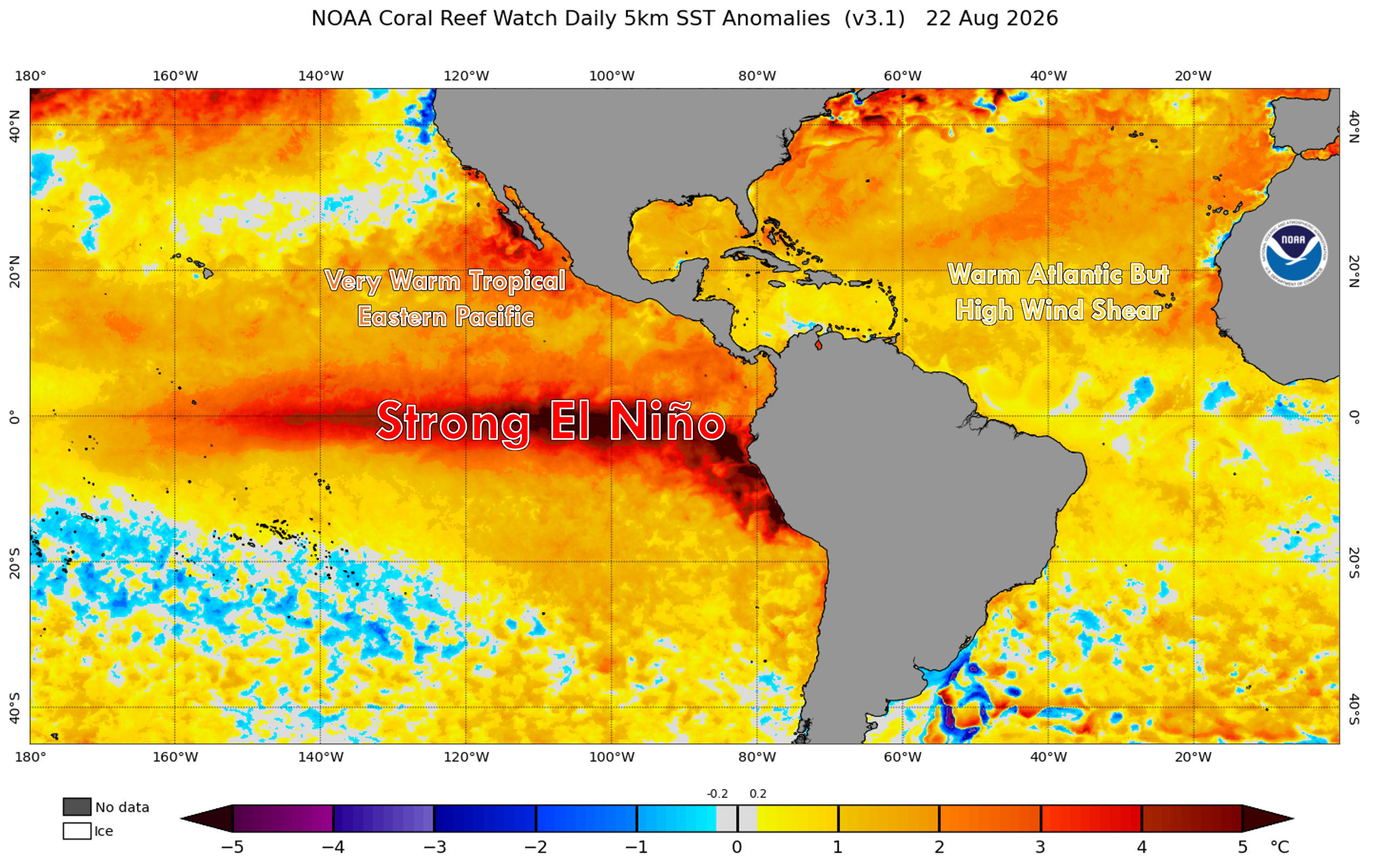
- 🌊 El Niño on deck — A historically strong El Niño is brewing and it may lead to an extended monsoon season.

Go Premium, get all the perks.
Daily Forecast Updates
Get our daily forecast discussion every morning delivered to your inbox.
All Our Model Data
Access to all our Colorado-centric high-resolution weather model graphics. Seriously — every one!
Ski & Hiking Forecasts
6-day forecasts for all the Colorado ski resorts, plus more than 120 hiking trails, including every 14er.
Smoke Forecasts
Wildfire smoke concentration predictions up to 72 hours into the future.
Exclusive Content
Weekend outlooks every Thursday, bonus storm updates, historical data and much more!
No Advertisements
Enjoy ad-free viewing on the entire site.
Winter Set the Stage
AAfter a record‑warm, record‑dry winter and spring, the West entered the summer already on life support. Snowpack was abysmal across the region, and Colorado began May in its worst drought since the week of the Marshall Fire.
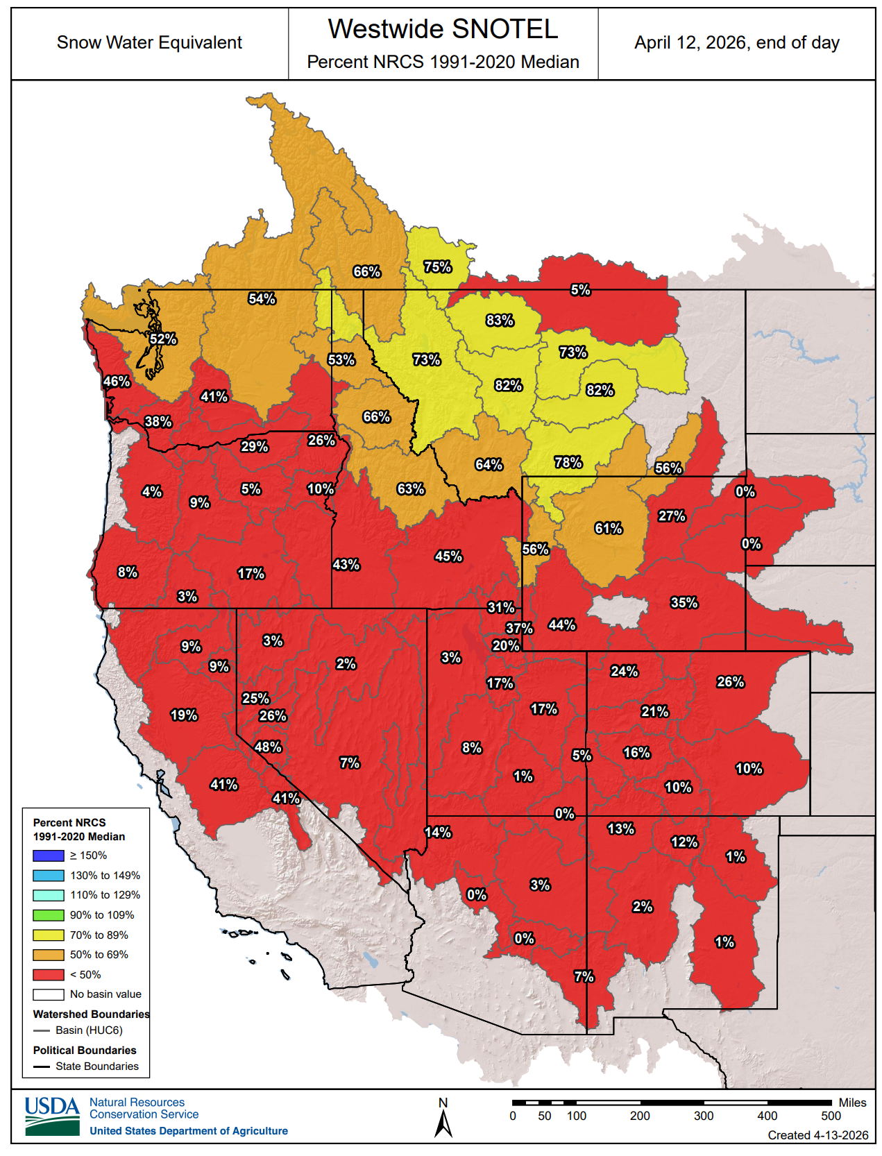
Even with two potent May systems — including the late‑season snowstorm that became our biggest dump of the year — the moisture only nudged drought conditions one category better for parts of the Front Range. The atmosphere simply had too much ground to make up.
Early El Niño: Dry Lightning and Explosive Fire Growth
A developing El Niño through 2026 was expected to eventually juice the monsoon, but its onset is notorious for dry lightning, and unfortunately that textbook signal we called out months in advance verified. Late June into early July saw a burst of wildfire activity across the Four Corners as the first hints of monsoon moisture arrived without meaningful rainfall.
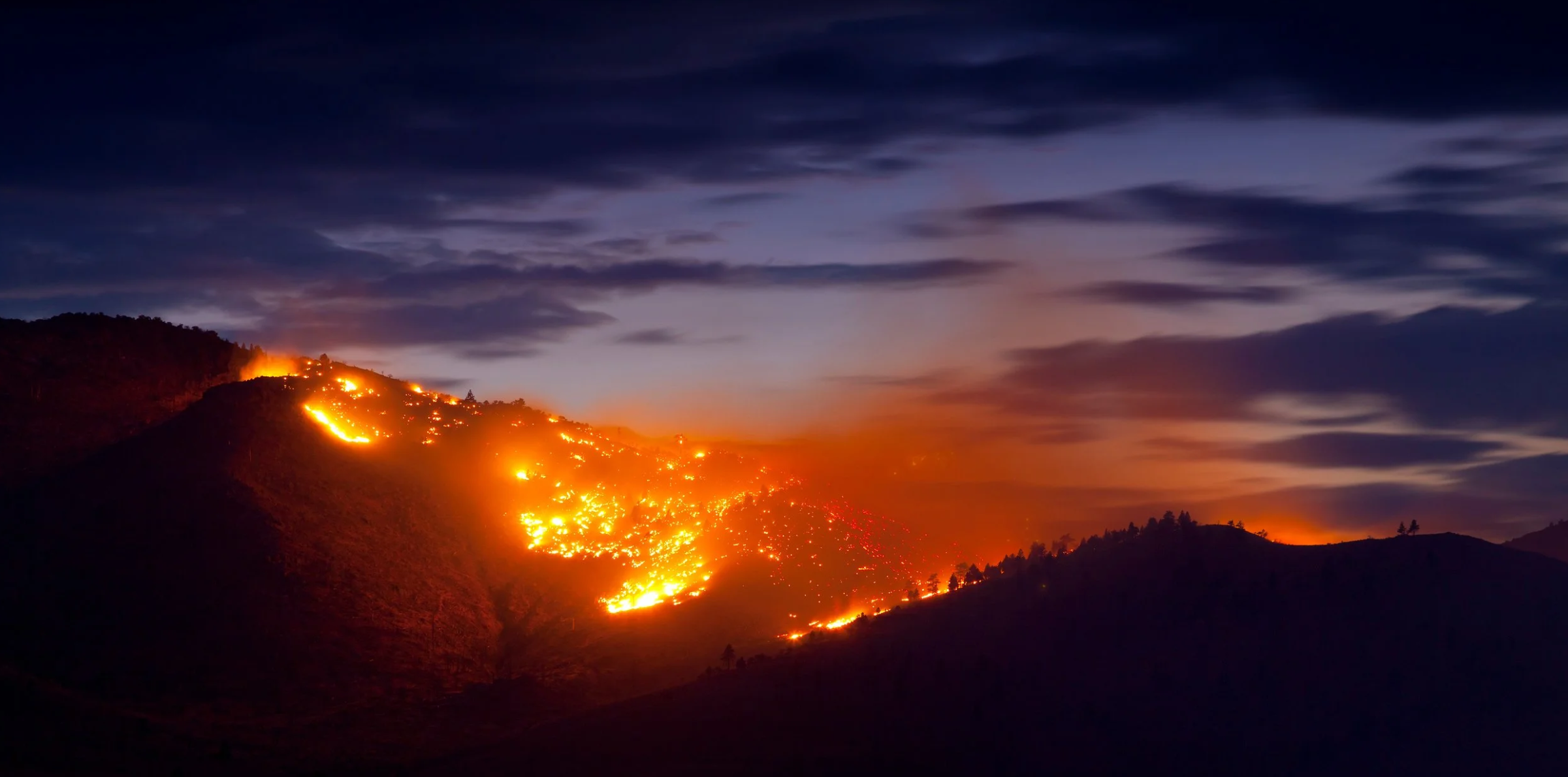
Gold Mountain Fire, June 2026, Ouray CO
Colorado’s Front Range has been lucky so far — with only intermittent smoke and a handful of quickly‑contained starts around the area. The rest of the state has not been so fortunate. Nearly 250,000 acres have burned statewide so far in 2026, with almost half tied to the devastating Aspen Acres Fire southwest of Pueblo. Two months later, that fire still isn’t fully contained. Ironically, the burn scar has been repeatedly hammered by flash flooding and debris flows this summer as monsoon storms dumped on terrain stripped bare of its vegetation.
A Monsoon Season That Never Found Its Rhythm
Since early July, large fire growth in the Southwest has slowed, but small ignitions remain common. Part of the reason? A near‑total lack of rainfall. High pressure has been a brutal, immovable fixture over Colorado this summer — the kind of stagnant ridge that in a typical monsoon year would sit farther east, allowing deeper subtropical moisture to surge northward as depicted in the diagram below.
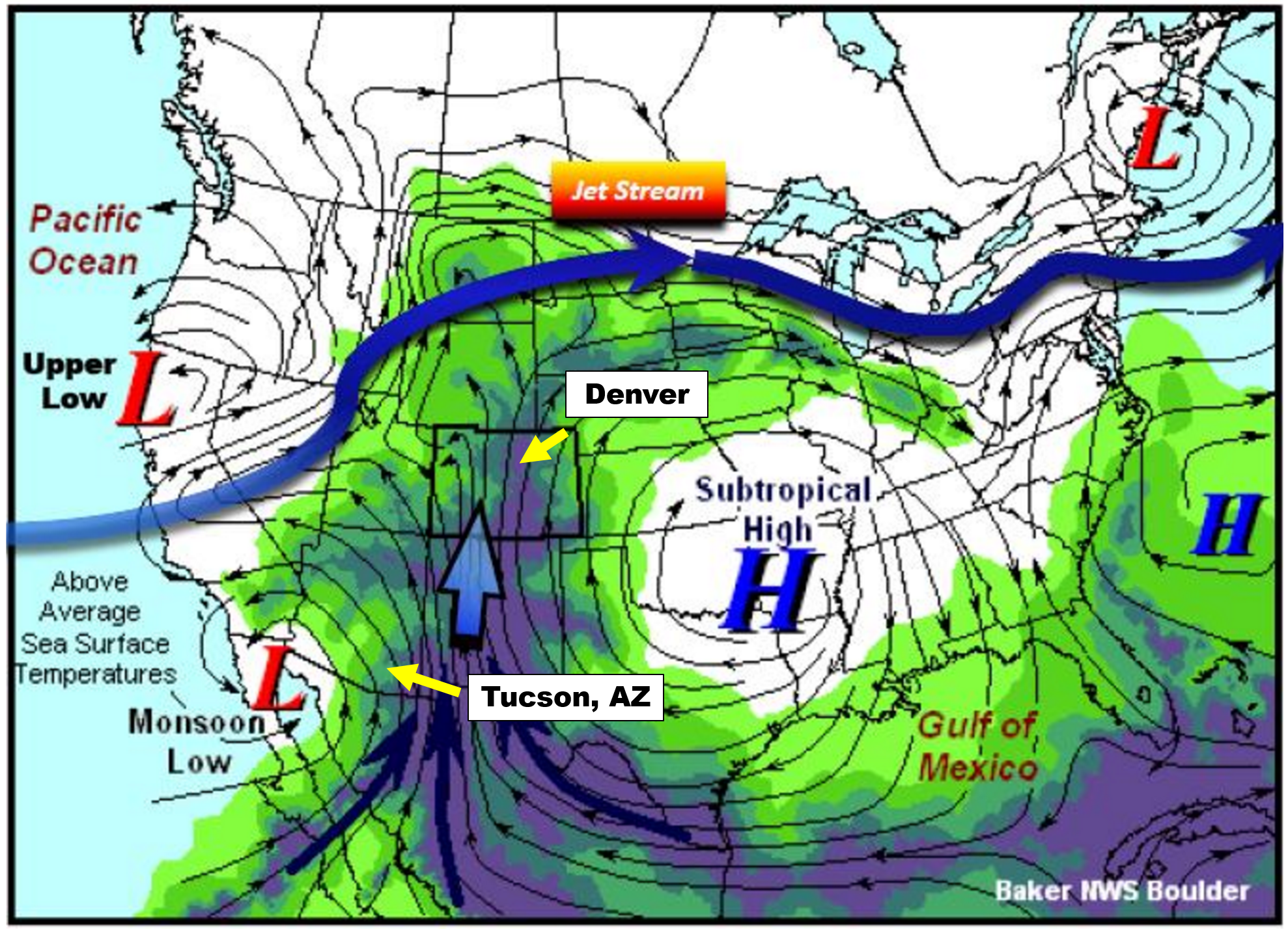
Too many of our weekly outlook discussions this summer have been nothing more than a few paragraphs about how little the huge, dominant heat dome blanketing the nation would move over the next five to seven days.
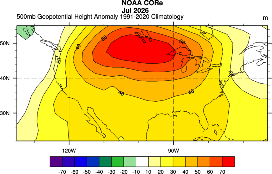
Instead, that ridge parked too close to home, throttling storm development and diverting the best moisture west into Utah, Nevada, and Idaho. Northeast Colorado occasionally tapped subtropical moisture, but often only after it recirculated from the northwest — moisture that had already traveled over vast deserts and mountain ranges, losing much of its punch.
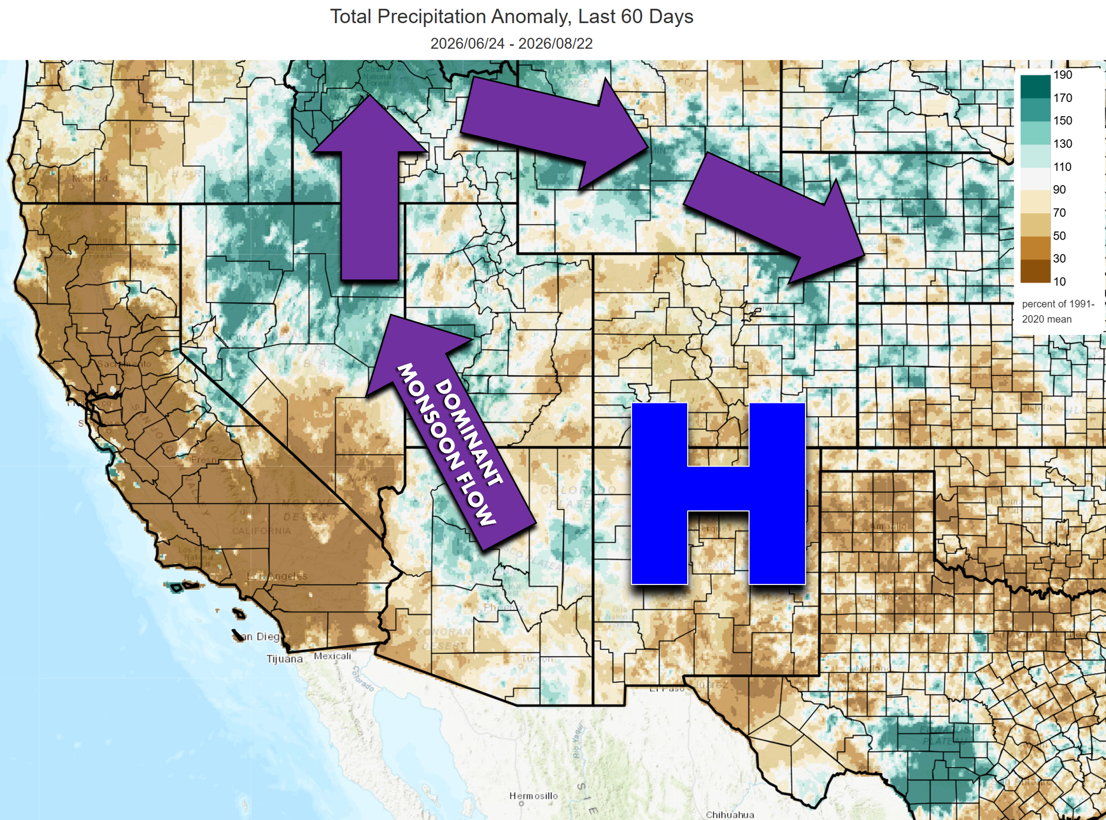
The result: monsoon rainfall collapsed statewide, with many regions receiving less than 50% of normal over the last two months.
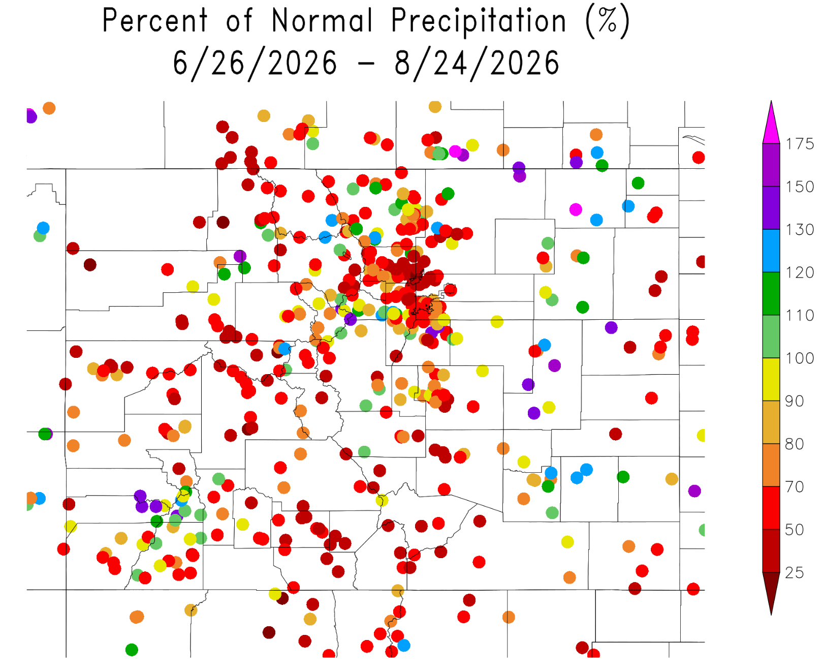
Colorado’s mountains have been absolutely skunked all summer long, and its frankly surprising that our fire season hasn’t been worse. Perhaps we can chalk this up to awareness, as human-caused fires haven’t been a major player. Only one of the top seven largest fires this summer — the Willow Fire near Leadville — was directly human‑sparked.
Improvement in August: Torrential but Sporadic Storms
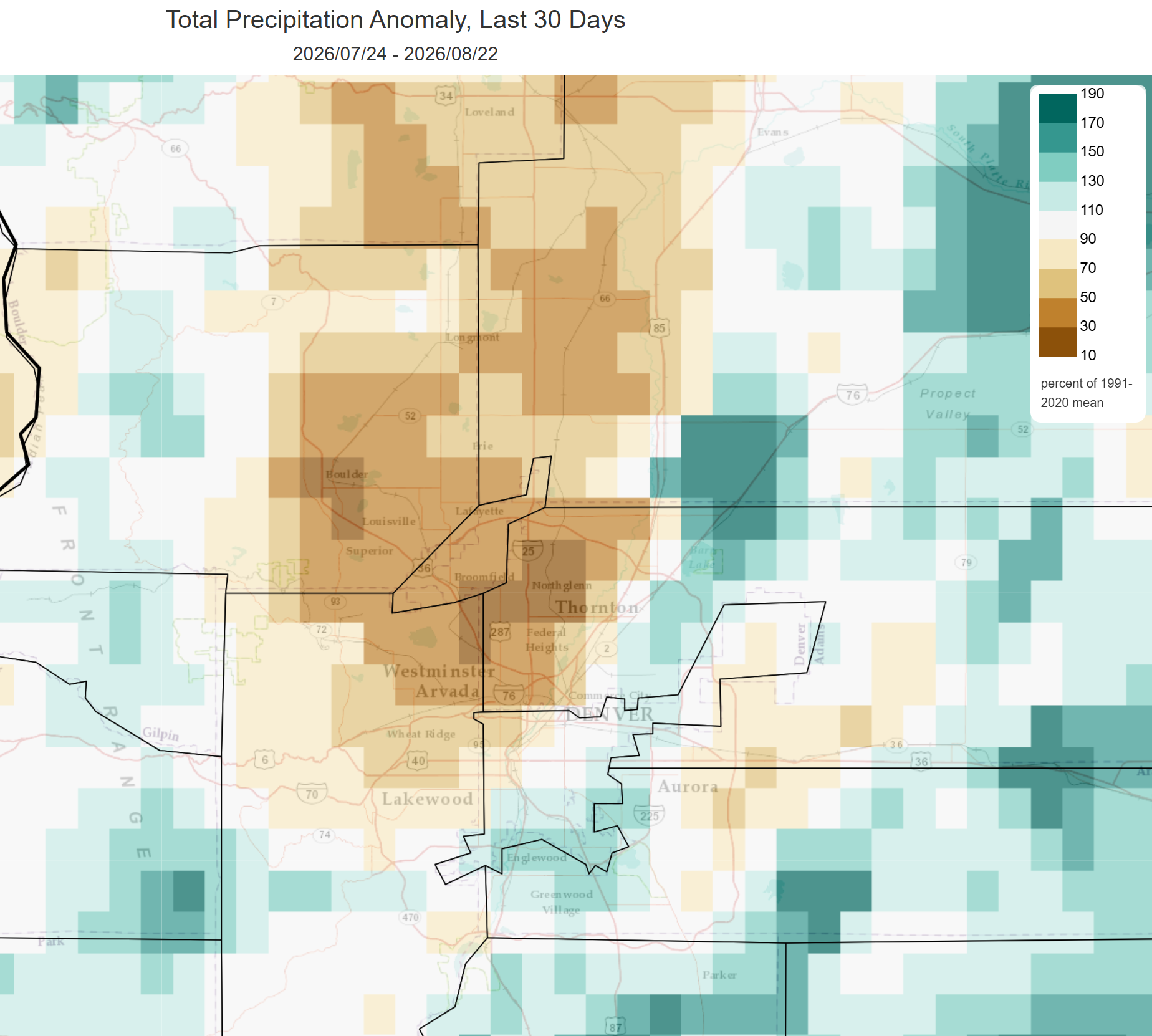
August brought a few slow‑moving, high‑rain‑rate storms along the Front Range. Some neighborhoods endured repeated flash flooding and even bouts of deeply accumulating hail.
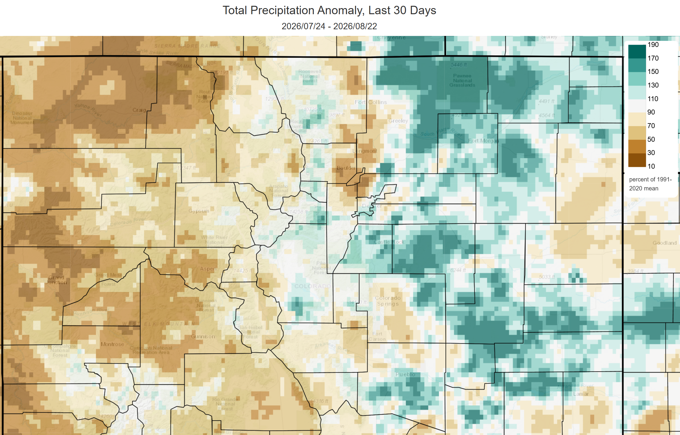
Others — including eastern Boulder County, Broomfield, Westminster, Arvada, and Thornton — saw almost nothing over the last month. Many of you have voiced frustration, and we hear you. It’s definitely maddening as meteorologists to forecast rain so many days and have it literally never pan out in some locations, including in the area our team calls home.
Drought and Fire Danger: Critically Dry, Ready to Burn
The ongoing drought has left the wildland-urban interface surrounding the Metro area is critically dry, exceptionally brown and ready to burn. We can’t stress enough how terrible things are out there right now. Only the cacti and a few species of weeds remain green in the open prairie surrounding Boulder. The photo below was taken a few days ago within the Marshall Fire burn scar. The one silver lining is that Spring 2026 was so dry as well that vegetation growth was minimal, reducing fuel loading compared to 2021, a factor the greatly contributed to the scale and destruction on that fiery, late-December day.
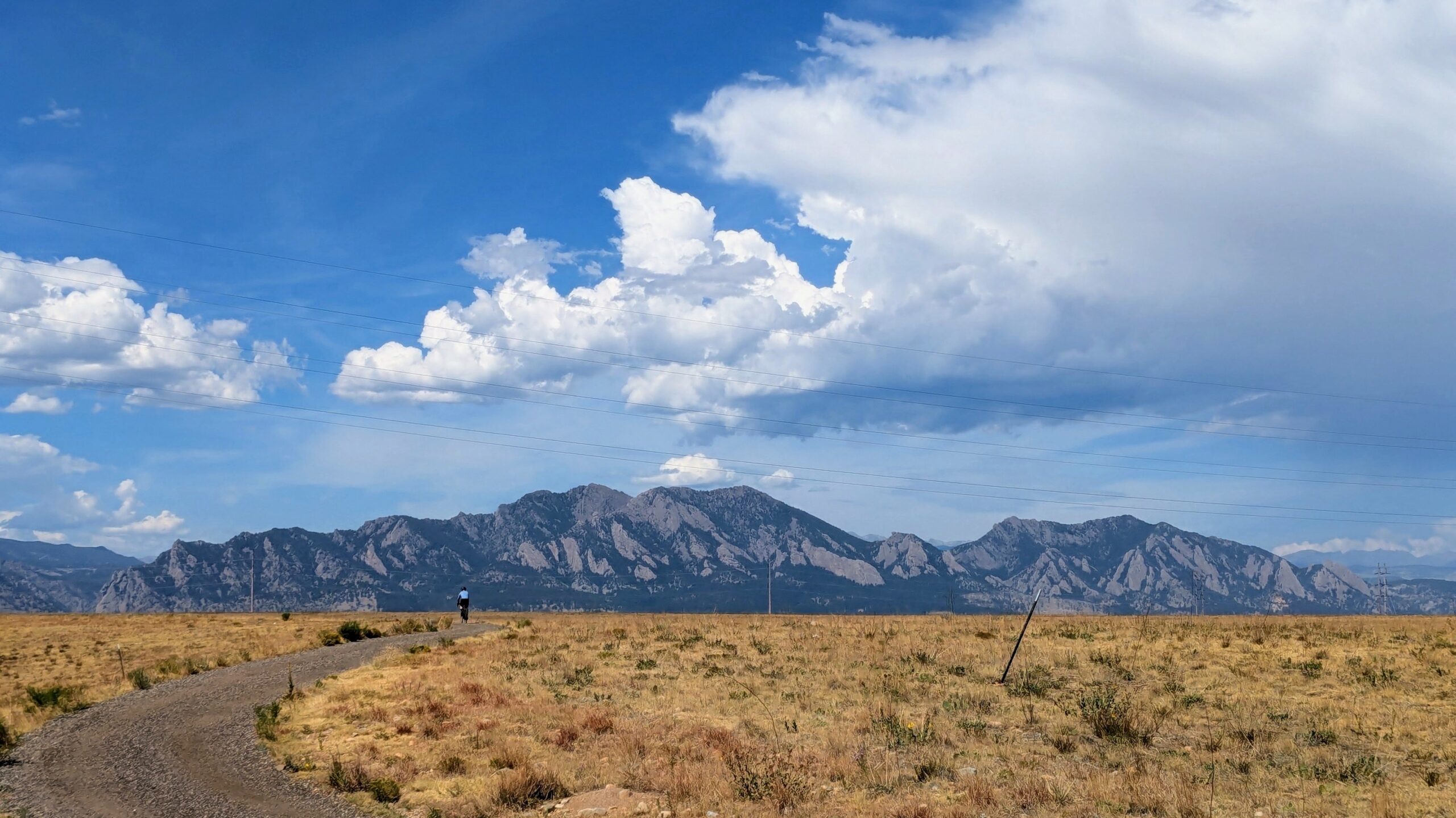
Photo taken near Superior CO inside the Marshall Fire burn area | 8/23/2026
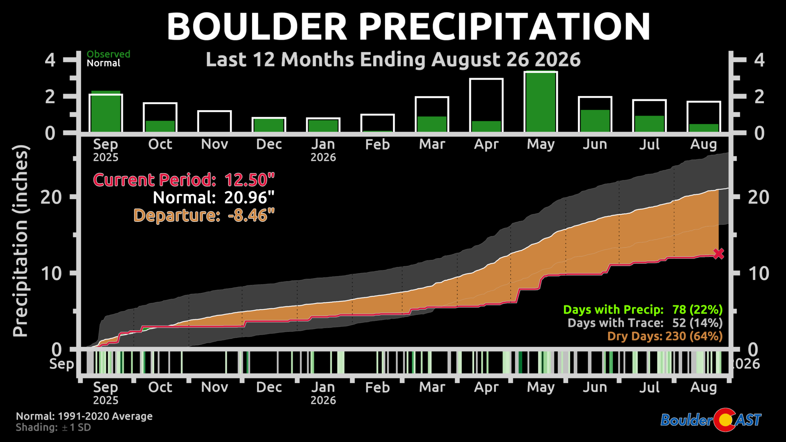
The actual numbers confirm what the landscape is telling us: Boulder has officially recorded just 1.43″ of rain since July 1, less than 50% of normal.
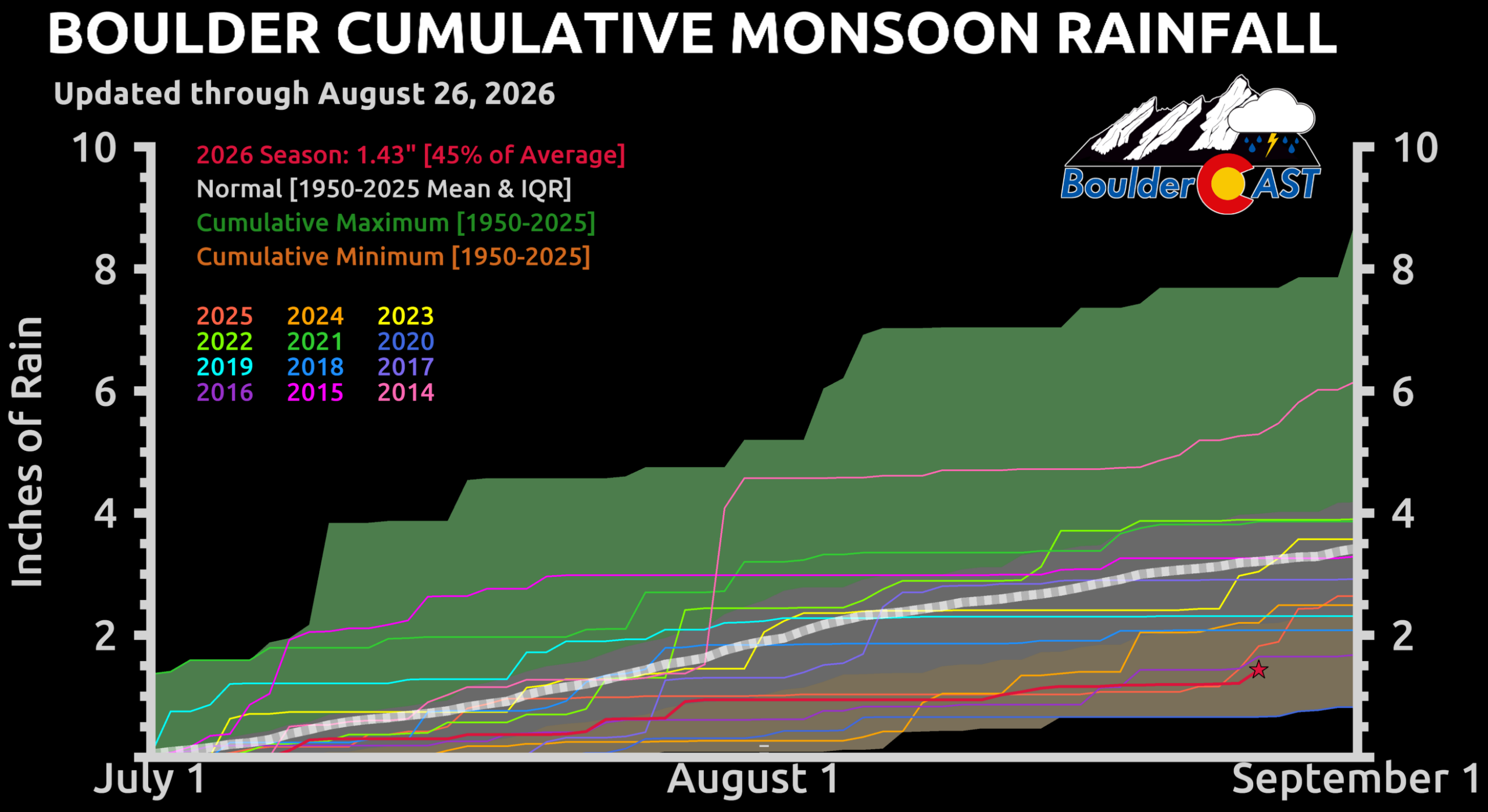
NOTE: That amount does include the brief deluge from the monsoon storm that occurred yesterday evening.

Monsoon thunderstorm hitting Boulder Wednesday evening, August 26 2026.
The lack of rainfall is not for lack of stormy days — Boulder logged 31 days of rainfall since July 1st, more or less completely normal for the same stretch. The issue is that almost all of those days produced only a trace or a few hundredths of an inch of rain from weak, dying showers or near-miss storms.

Denver’s story is slightly better: nearly twice Boulder’s rainfall, though still only ~75% of normal.

Interestingly, Denver recorded rain on fewer days (24), but those days were far more productive — seven exceeded 0.20″, compared to Boulder’s two occurrences.

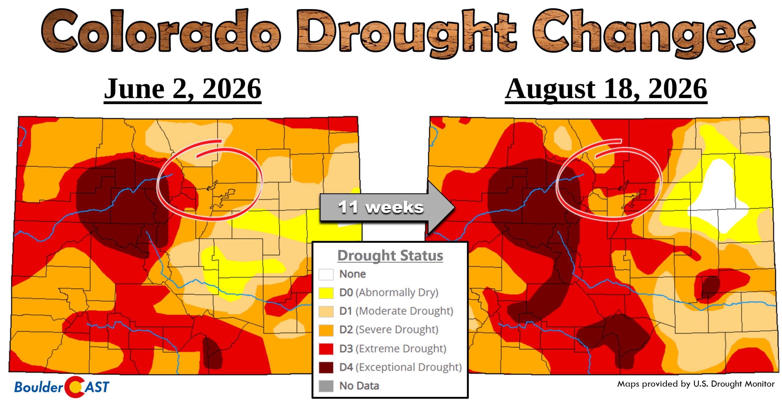
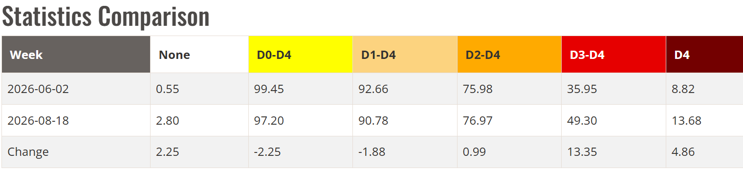
With the 2026 summer monsoon largely botched, drought has intensified. Roughly 50% of Colorado is now in Extreme or Exceptional Drought, up from ~35% in early June.
Historic Western Warmth: The Summer That Wouldn’t Cool Down
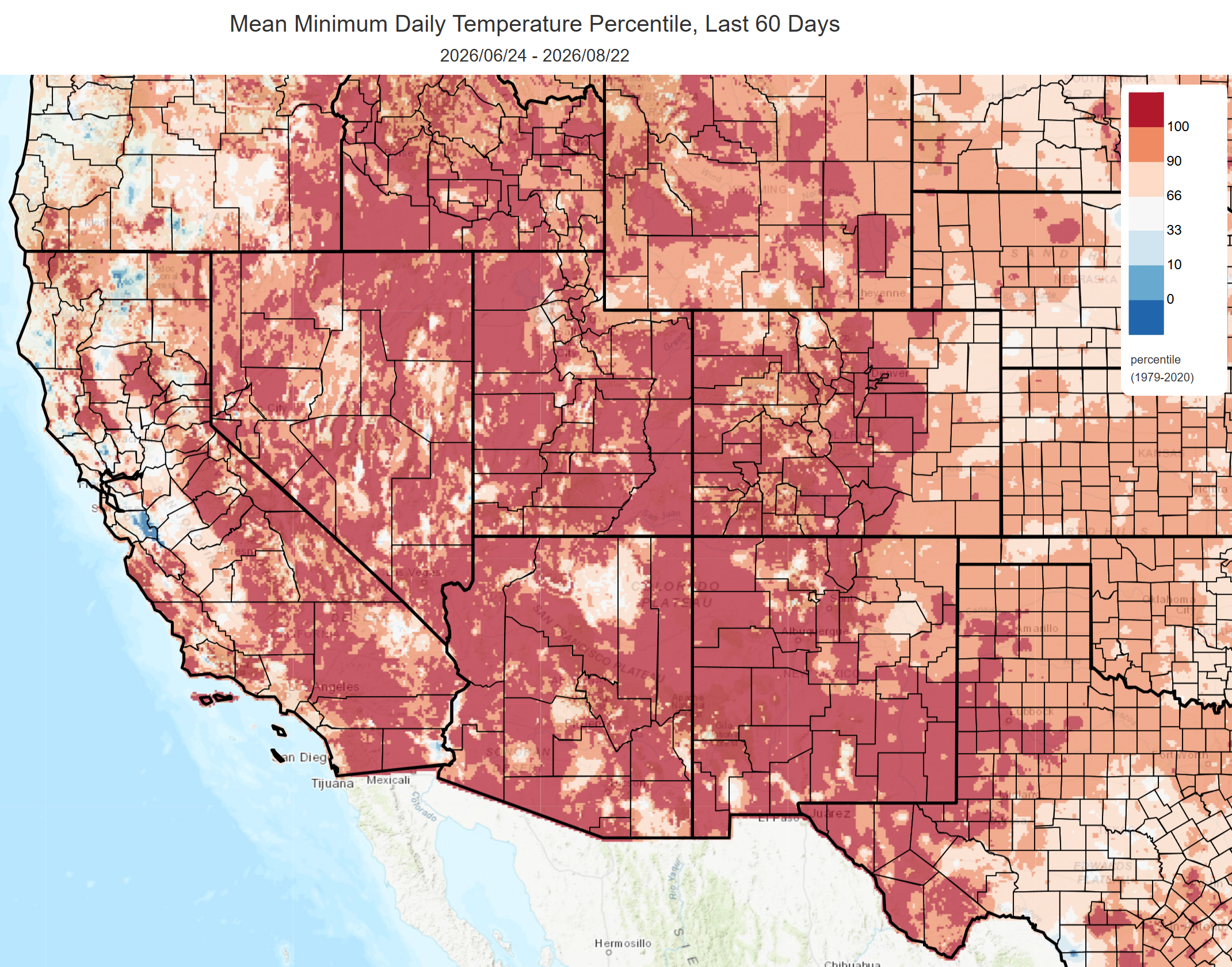
Rain wasn’t the only missing ingredient this summer — nearly every single cold front failed spectacularly. Much of the West, including the western two‑thirds of Colorado, is experiencing its warmest summer on record.
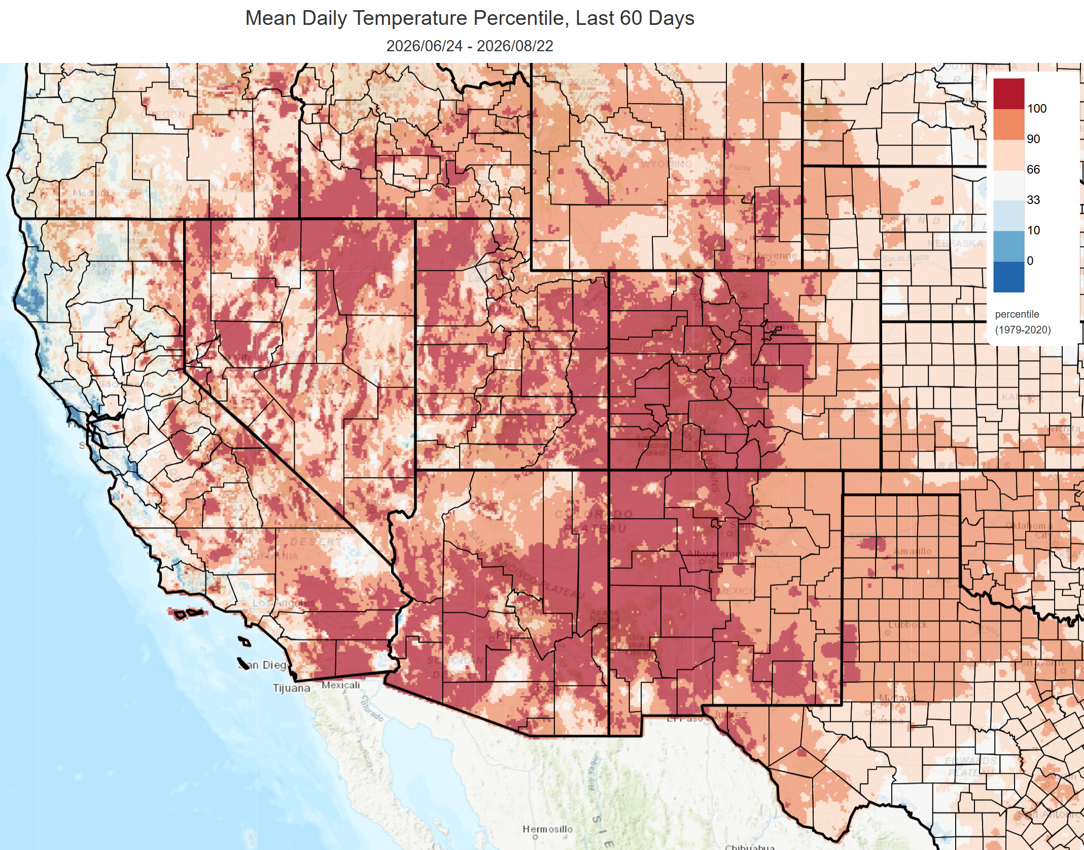
Daytime highs were hot but generally not unprecedented for most areas. As we’ll show in a moment, our area was an exception.
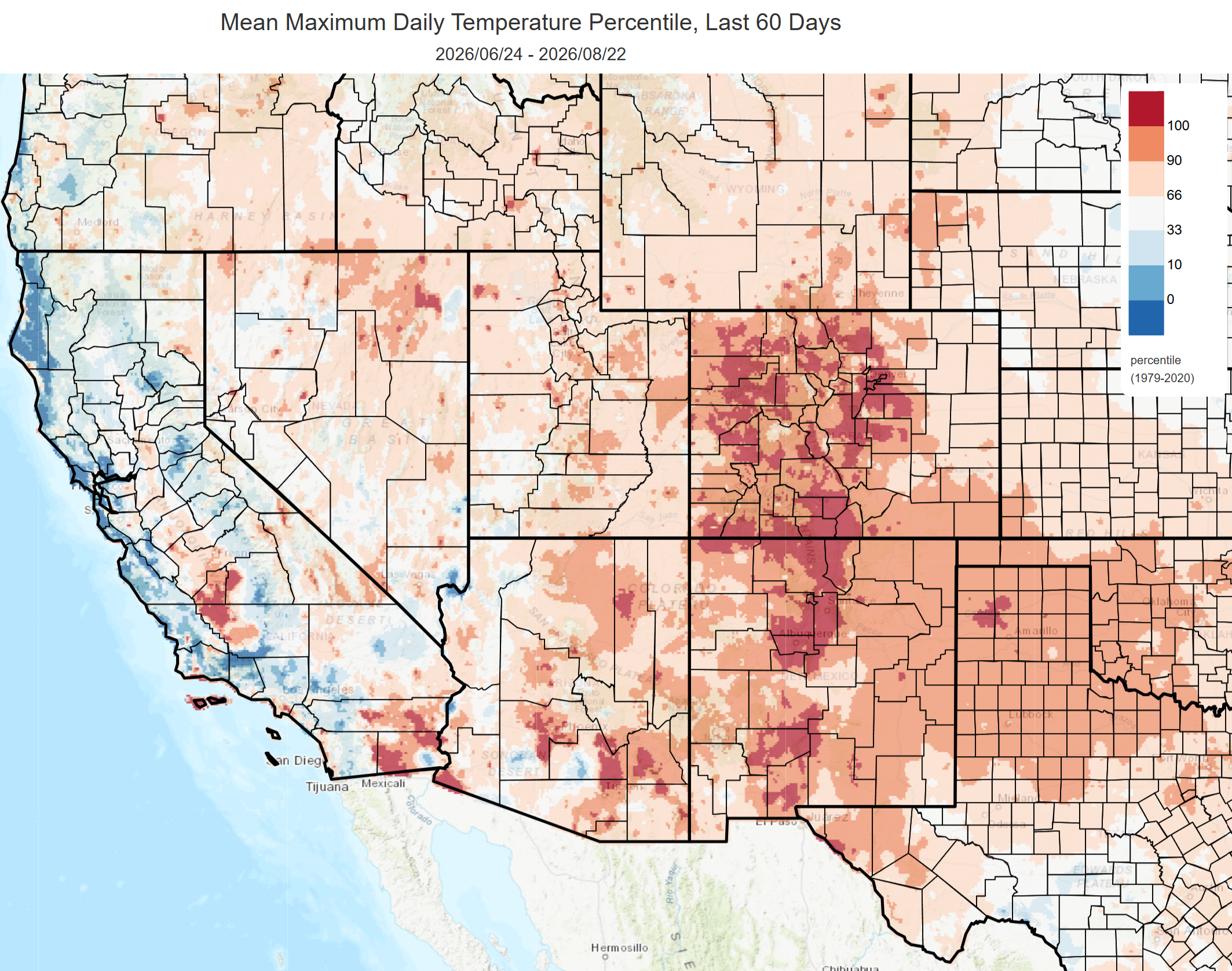
The real anomaly was overnight lows, which were wildly above normal across most western states. Warm nights are typically tied to increased net longwave radiation, often from nocturnal cloud cover, increased atmospheric water vapor, or elevated soil moisture. But what caused this summer’s warm nights?
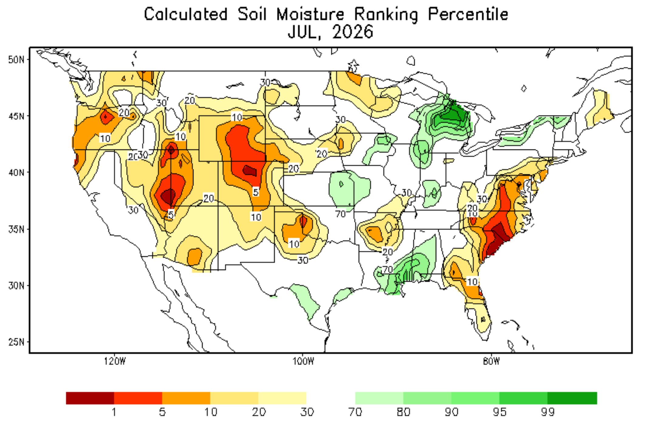
We’ll, soil moisture was the driest on record in July along the Front Range, so that wasn’t a contributor. In fact, dry soil would act to makes night’s cooler and days hotter due to a lower heat capacity compared to moist soil.
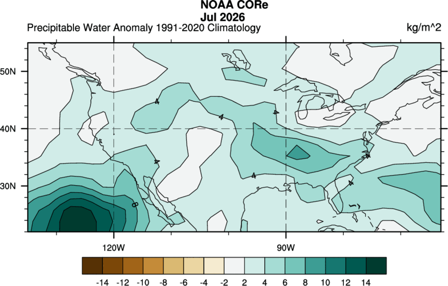
Atmospheric moisture (precipitable water) was indeed above normal nationally in July, but not dramatically so locally in the Southwest. Increased water vapor in the atmosphere could keep us warmer at night, but this isn’t nearly enough to be historic.
The eastern Pacific and Gulf of Mexico were extremely warm, supplying additional heat and moisture, though this would not discriminate towards night over day.
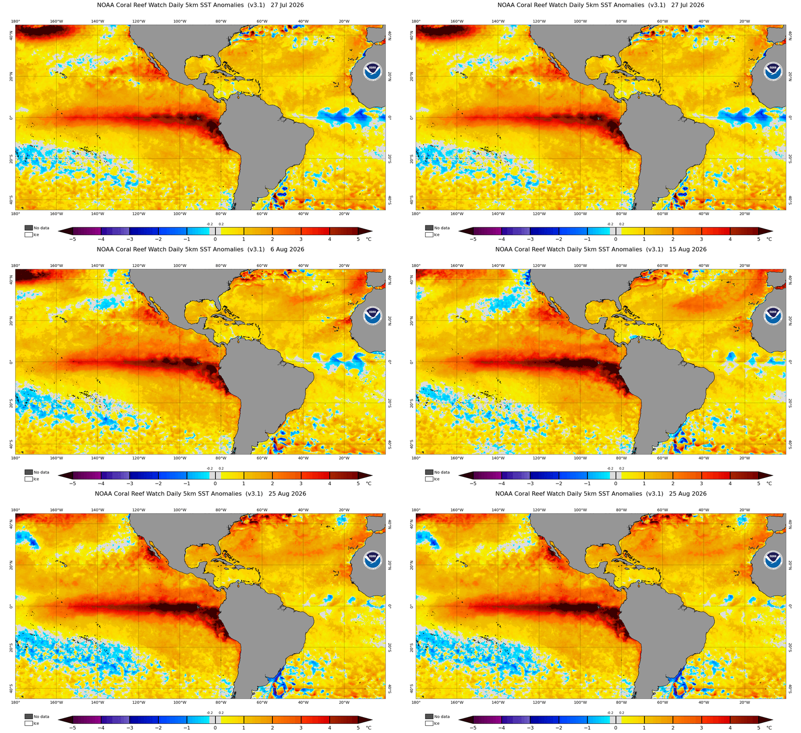
I spy with my little eye…something really warm!
Another contributing factor could be the wildfire smoke, which has been thick across the West much of the summer, though not too bad in Colorado of late. Increased smoke aerosols could explain why daytime highs aren’t as warm (scattering/absorption of sunlight), while at the same time increasing net longwave radiation to make nights relatively warmer. This probably wasn’t a major contributor though as even much less smoky areas across the Great Basin has nearly unprecedented relative warmth at night this summer.
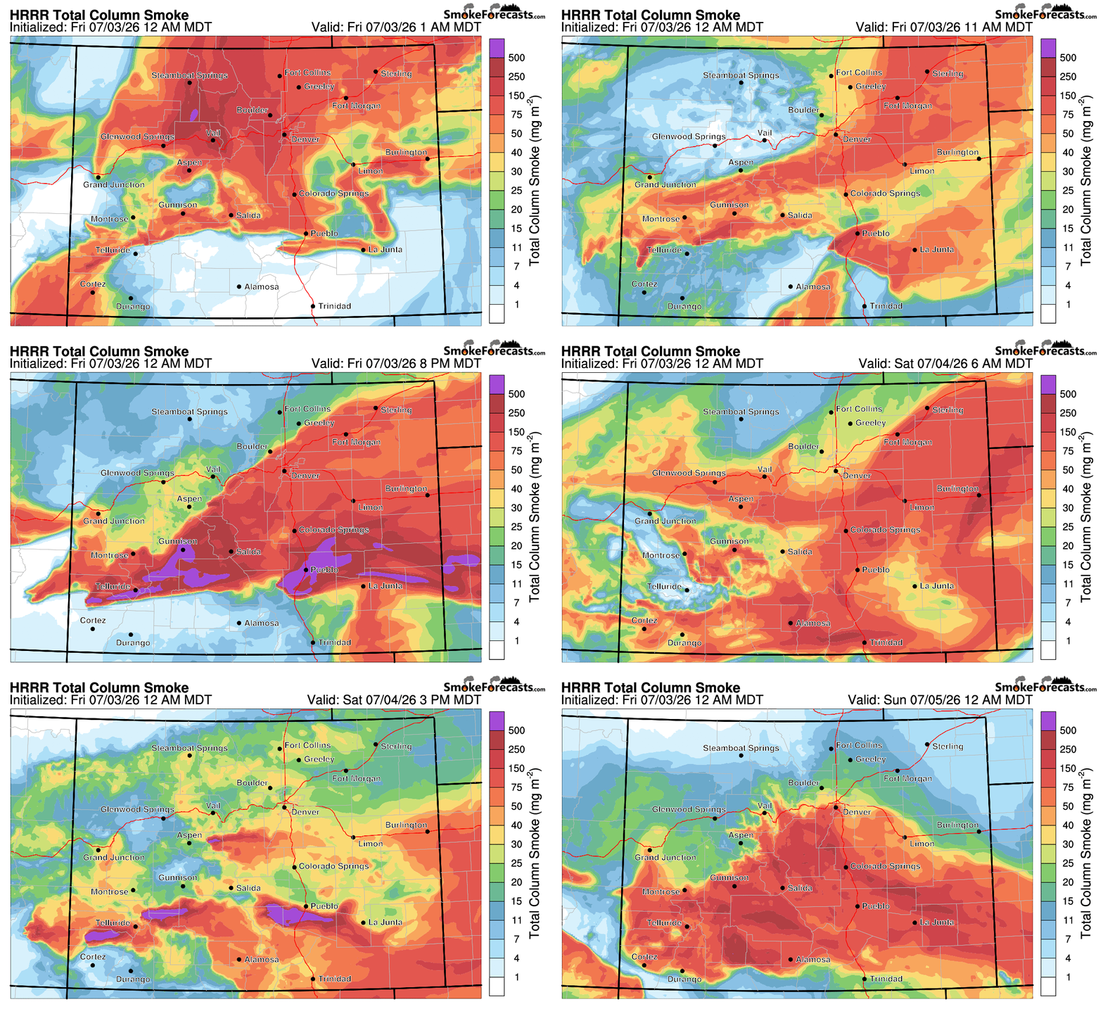
Honestly, it’s a fascinating and not fully understood setup of how the West’s nights ended up so warm across the board this summer. If you have theories, drop them in the comments.
Exceptional Warmth in Boulder and Denver This Summer
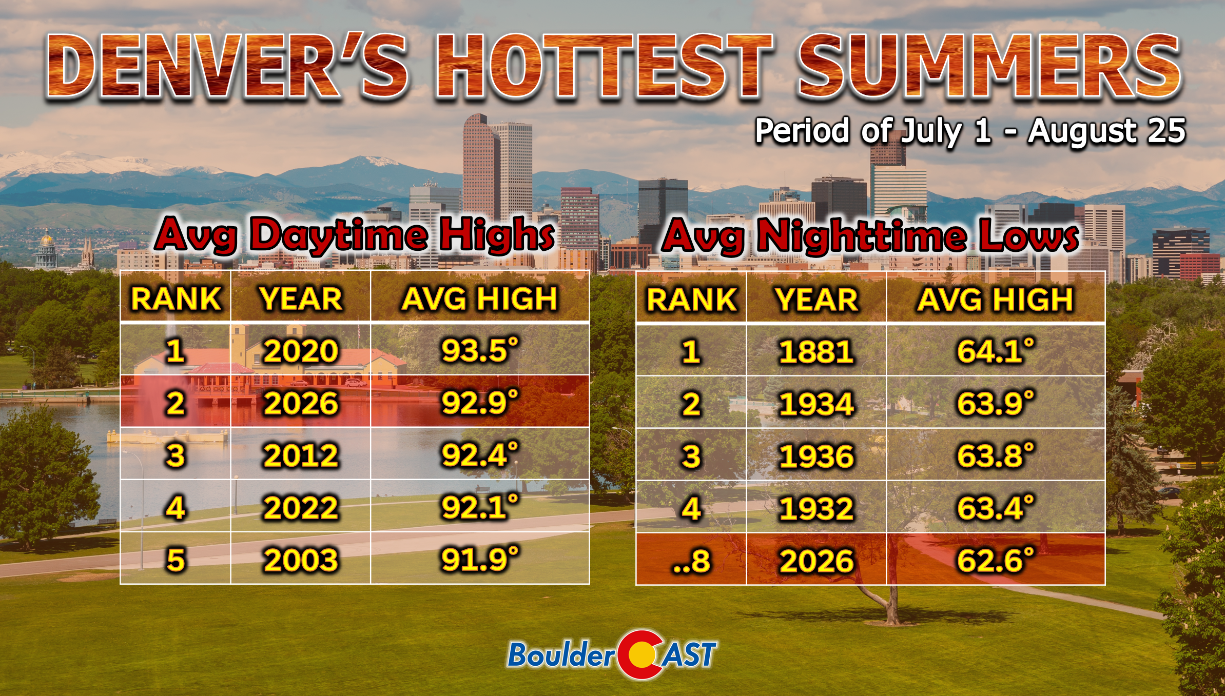
For July 1–August 25, Denver logged its 2nd warmest period on record, with the 2nd warmest daytime highs and 8th warmest overnight lows. Regardless of any questionable pre‑1940s data, this is almost certainly the warmest set of daytime highs and overnight lows anyone alive has experienced in our area.
Boulder set at least 15 new heat-related records just since July 1st.
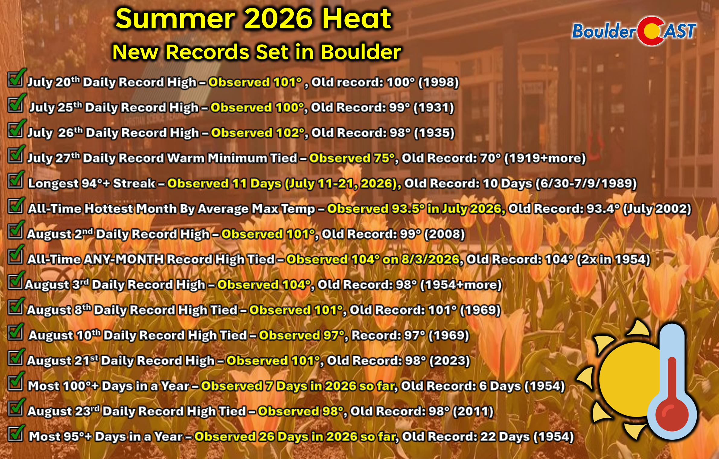
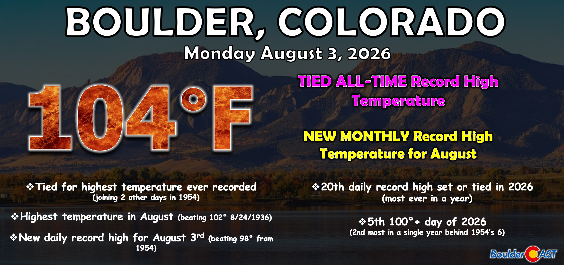
The most notable is reaching 104° on August 3, tying the city’s all-time record high temperature that had not been reached since 1954 (which was measured in a decade with questionable data).
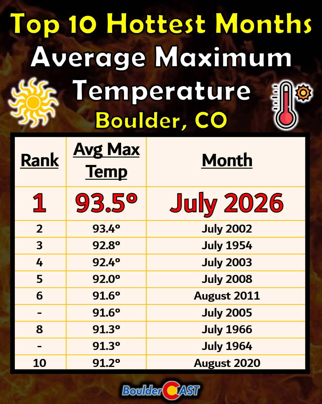
Runner up record goes to a new all-time monthly record for average maximum temperature which was observed in July. The average high temperature during the month was 93.5°, warmer than any month dating back to the late 1800s.
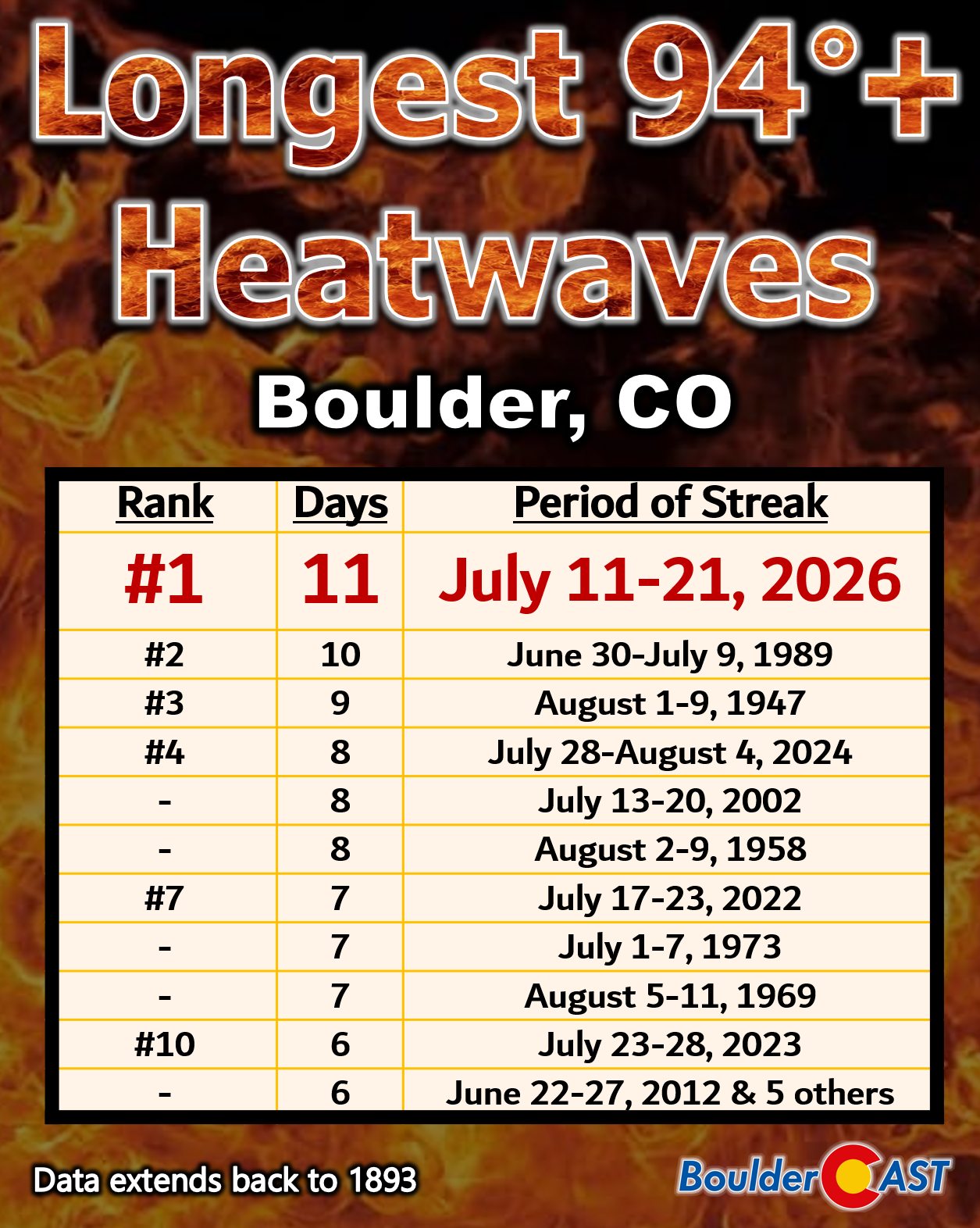
We’ll also give an honorable mention to Boulder’s new longest 94°+ heatwave which spanned from July 11-21, 2026.
Oh and of course we can’t forget to mention that new all-time records were set for the number of 95° and 100° days, with 26 and 7 occurrences respectively. Boulder is also well on-pace for a Top 3 finish of 90° days. If that record also falls, it won’t be until sometime later in September.
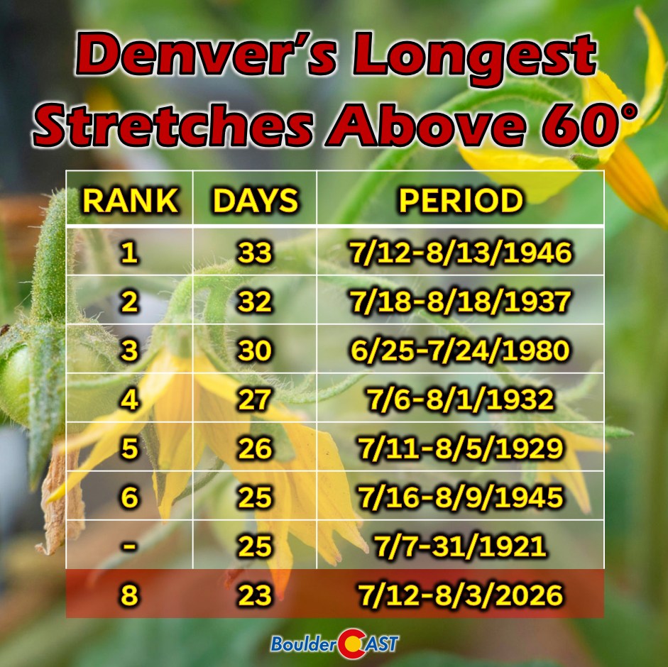
 Denver logged its own brand of persistent warmth this summer. One standout metric was a 23‑day run of overnight lows staying above 60°F — the 8th‑longest streak on record and the longest since 1980. For gardeners, those warm nights should have been prime conditions for tomato flowering and fruit set, even if the extreme daytime heat may have counteracted some of the benefits. If your backyard crop thrived in the balmy nights this summer, let us know in the comments — we’d love to hear how your garden handled this extreme summer.
Year‑to‑Date: The Warmest on Record for Nearly All of Colorado
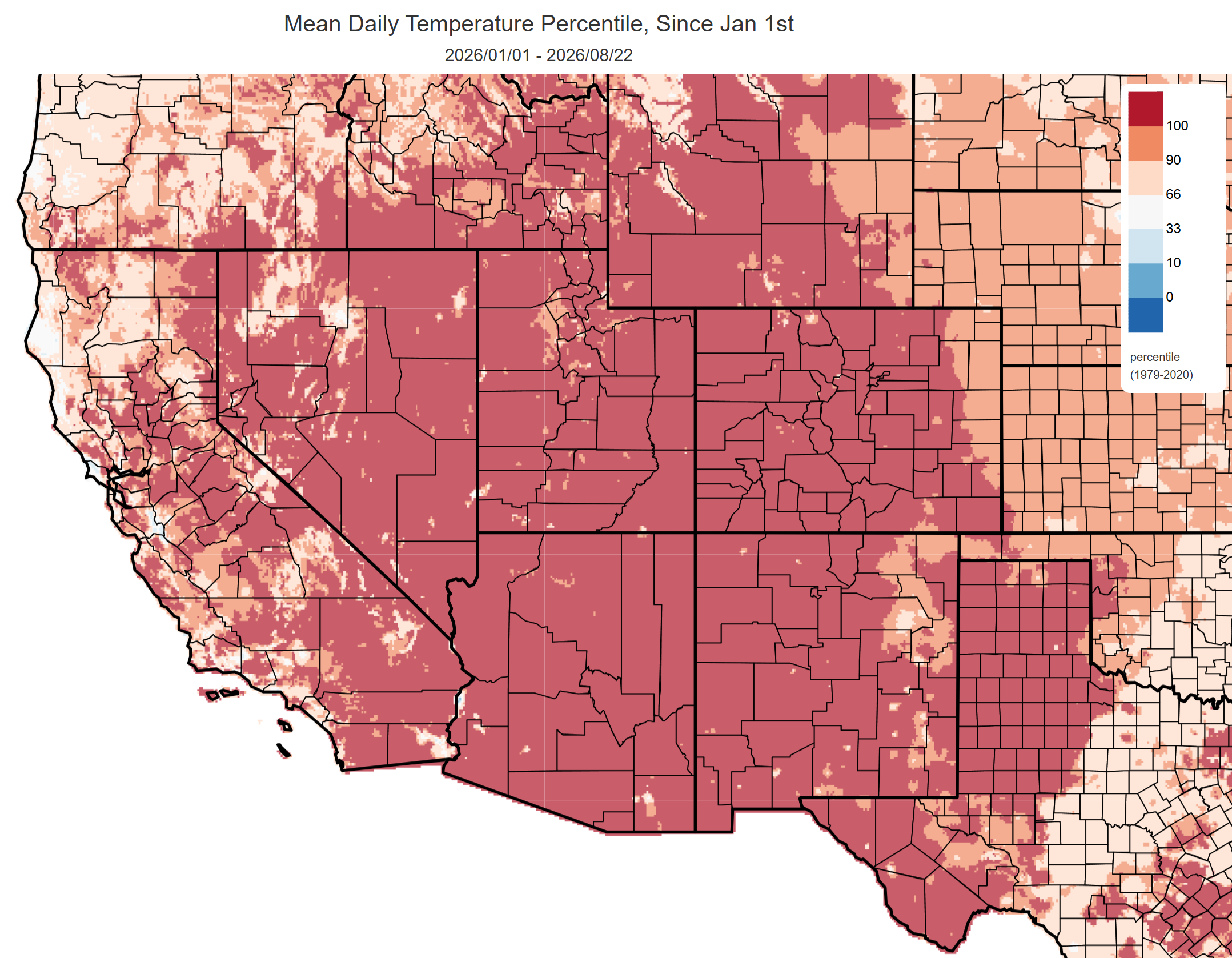
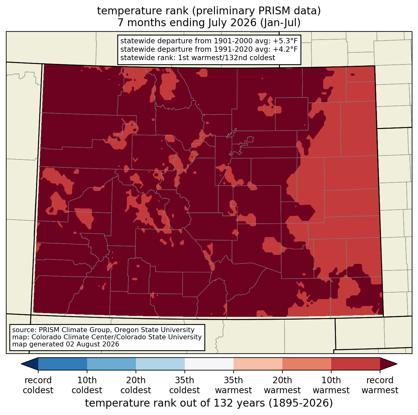
Stack the historically warm winter, the snow‑starved spring, and the sizzling monsoon‑misfire of a summer together, and it’s no surprise: 2026-to-date is the warmest year on record for roughly 90% of Colorado and nearly the entire Four Corners region.
Where Do We Go From Here?
Summer 2026 will conclude as a season defined by a dominant heat dome that suppressed vertical motion, redirected subtropical moisture away from Colorado, and maintained anomalously warm boundary‑layer conditions day and night for weeks on end. The monsoon never established a coherent moisture transport pathway into the Front Range, leaving Boulder and Denver with frequent but feeble storms this summer, the Mountains almost completely dry, and now nearly 50% of the state in Extreme or Exceptional Drought. Record‑warm overnight lows, record‑dry soils, and a stagnant ridge produced a feedback loop that limited convective efficiency, reduced storm longevity, and kept fuels critically dry despite frequent “rainy days” that delivered only a sprinkle of output. This summer, and frankly the last year, have been a preview of the kind of atmospheric volatility Colorado, and all of the Southwest states which depend on our rain and snow, must be ready for moving forward.
We’ll have another long-form update next week covering the impending historically strong El Niño, including what it could mean for Colorado’s autumn pattern — specifically whether enhanced tropical cyclone activity and a reconfigured subtropical jet could prolong the monsoon well into September and how the transition to snow season may unfold.
We’ve been seeing a ton of hype locally for an epic ski season and full-on drought recovery happening this winter, but sadly it’s not that simple. It never is. More to come.
Spread the word, share this critical update on Colorado weather:
Go Premium, get all the perks.
Daily Forecast Updates
Get our daily forecast discussion every morning delivered to your inbox.
All Our Model Data
Access to all our Colorado-centric high-resolution weather model graphics. Seriously — every one!
Ski & Hiking Forecasts
6-day forecasts for all the Colorado ski resorts, plus more than 120 hiking trails, including every 14er.
Smoke Forecasts
Wildfire smoke concentration predictions up to 72 hours into the future.
Exclusive Content
Weekend outlooks every Thursday, bonus storm updates, historical data and much more!
No Advertisements
Enjoy ad-free viewing on the entire site.












Leave a Reply
You must be logged in to post a comment.