Nothing is ever easy in Front Range weather! The incoming spring, or shall we say winter, storm remains a very challenging forecast as models struggle to resolve where the heaviest precipitation will fall Wednesday into Thursday, the precise timing on when rain will change to snow, and exactly where temperatures will bottom out at overnight. All of these factors are coming together to make for a complicated blend of moderate to heavy rain and soupy snow this evening into Thursday. Most models would have us believe a deluge of precipitation is about to unleash on the Denver area, but there are some red flags. We discuss the latest on this evolving storm which is sure to create quite the mess for everyone over the next 36 hours.
We discuss Boulder and Denver weather every single day on BoulderCAST Premium. Sign up today to get access to our daily forecast discussions every morning, complete six-day skiing and hiking forecasts powered by machine learning, access to all our Front Range specific weather models, additional storm updates and much more!

The trend towards “big” precip
Just about every weather model is now predicting 0.75″ or more of precipitation for this event for the entirety of the Boulder and Denver Metro, with a preference for higher amounts in the Foothills and south of Denver across the Palmer Divide (1″+). A storm of this magnitude is significant for our arid climate and would account for roughly 5 to 10% of our annual precipitation!
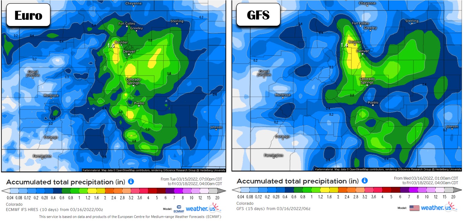
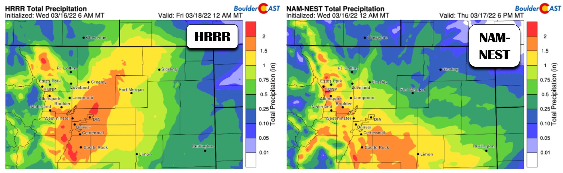
Some of the short-range, convective-allowing models are even more bullish with this storm’s potential with upwards of 1.5 to even 2″ in spots!
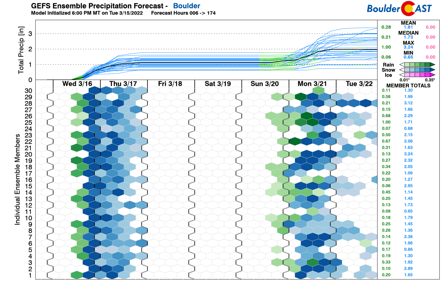
Both the ensemble mean and median precipitation amounts in Boulder and Denver are near or slightly above 1″.
According to just about every weather model out there, it’s all systems go for a big & wet spring storm…
The upslope conundrum
Of course it is great that most models are in agreement for a sizable dumping of moisture on us over the next 36 hours, but is it realistic? The track of the storm remains concerningly far south and the upslope doesn’t really impress. Note the mountain-level northerly flow indicated in the GFS model forecast below for Wednesday night at midnight. Straight out of the north in Boulder and even a hint towards downslope from Longmont to the Wyoming border!
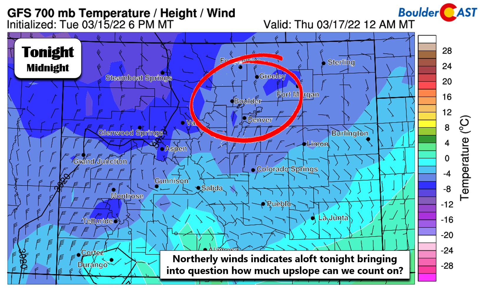
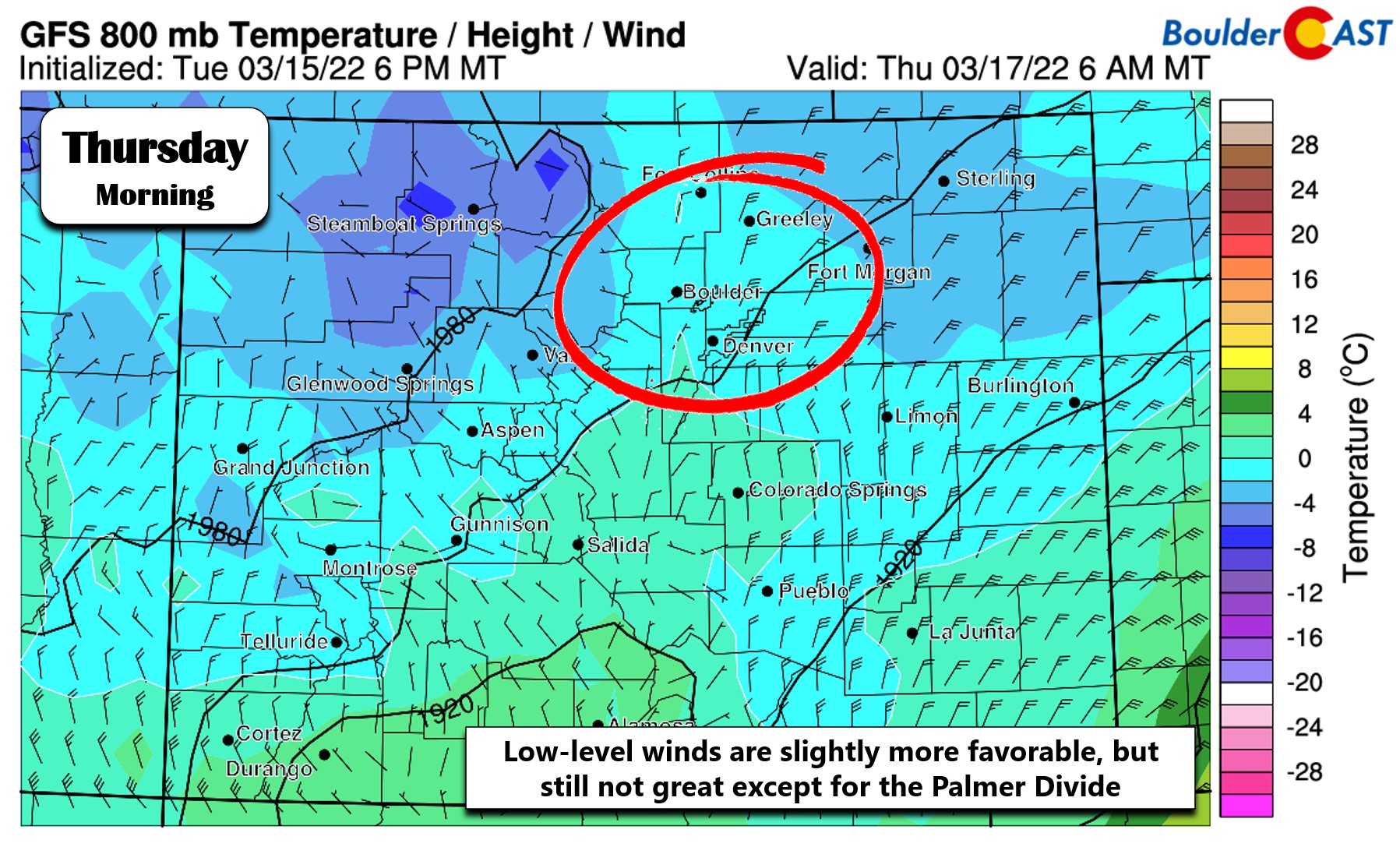
Winds near ground-level are shown to be more favorable out of the north-northeast, but just barely so. Ultimately this directionaly means we can’t really count on upslope to deliver the goods tonight, except in areas favored by primarily northerly flow like the Palmer Divide and the southern outskirts of Denver.
When will we change-over from rain to snow?
Even putting aside our hesitancy surrounding the modeled moisture deluge, the trickiness of the forecast in Boulder and Denver is compounded by a lack of truly cold air. If everything goes as planned, it will just barely get cold enough for the lower elevations to switch over to snow tonight with temperatures dropping to near the freezing mark or just below in most areas. There are still some stubborn model runs that don’t get cold enough for the snow to stick much (bottoming out at ~33-34°F). That does seem more plausible in the presence of northerly winds which will create downslope, compressional warming off the Cheyenne Ridge across the northern Front Range — watch for this in Longmont to Fort Collins to Greeley. This warm air may even spoil some of the party in Boulder. This is TBD.
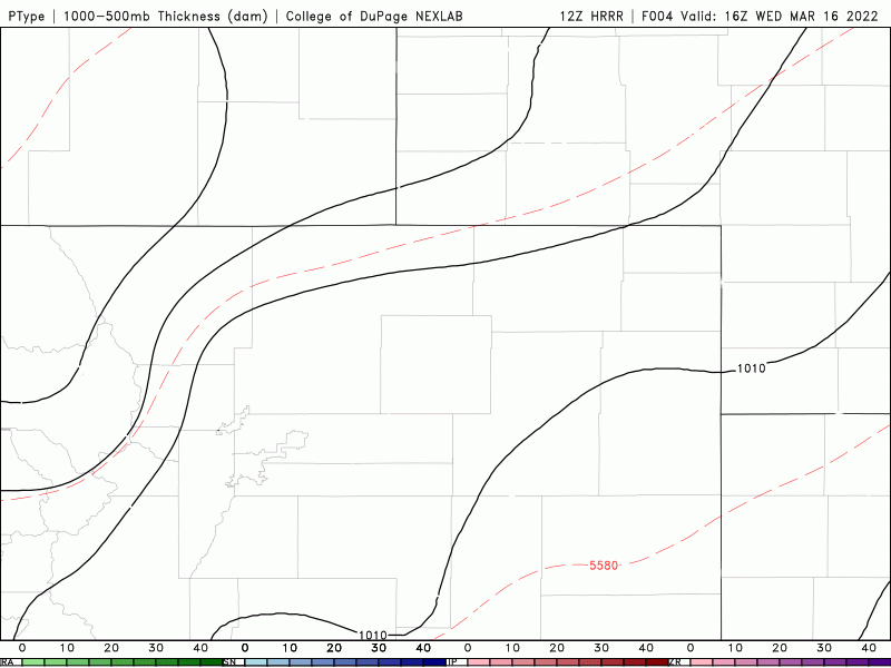
Our latest thinking has the change-over from rain/snow to all snow happening between 8PM and midnight in most locations. It could take longer in the typically warmer, low-lying areas like Longmont and Loveland and maybe even Gunbarrel. After the transition, it will be all snow through the rest of the night into Thursday morning. Lighter precipitation will linger into the second half of Thursday and would likely be a mix of rain and snow across the Metro area with minimal additional accumulation after the morning hours. The simulated radar precipitation type forecast animation below from the HRRR model shows how the transition from rain to wet snow could happen Wednesday evening and night.
Timing & impacts
- Wednesday early afternoon: Cooler temperatures in the 50’s with thick cloud cover but dry. It’s going to be a gloomy day!
- Wednesday afternoon into the evening: Precipitation chances ramp up across the entire area, with rain likely beginning by late afternoon or early evening across the Metro area and with snow in the higher Foothills.
- Wednesday mid to late evening: Colder air will filter in with temperatures falling into the 30’s and snow levels dropping quick. Rain will change to all snow across the entire area between 8PM and midnight.
- Wednesday night into Thursday morning: Snow continues through the overnight, heavy at times. Wet, slushy snow will certainly have an impact on the morning commute, especially in the western and southern suburbs of Denver. Roads will be snow-packed in the Foothills. Most of the accumulation will be over by mid-morning with the March sun and relatively mild temperatures melting the slushy snow quickly through the day.
- Thursday afternoon into the evening: Light, showery snow will linger through the day, likely mixing with rain at times across the lower elevations. Little additional accumulation is expected.
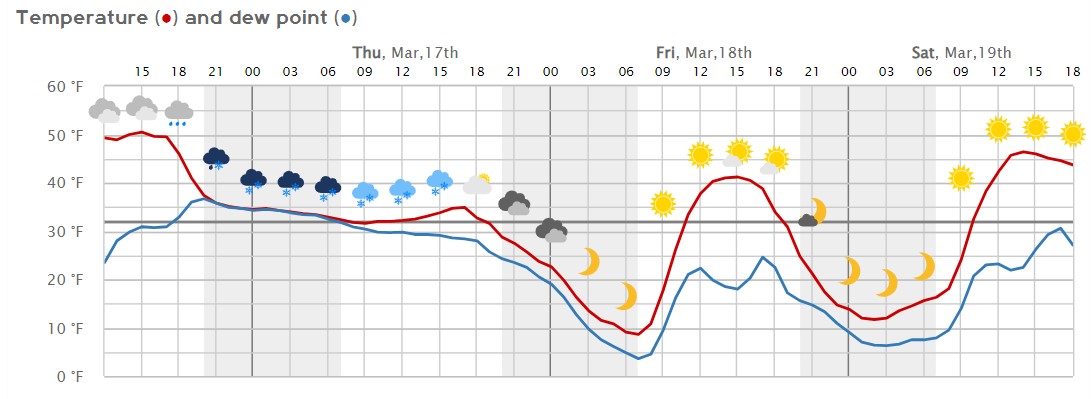
Denver meteogram for the next 72 hours
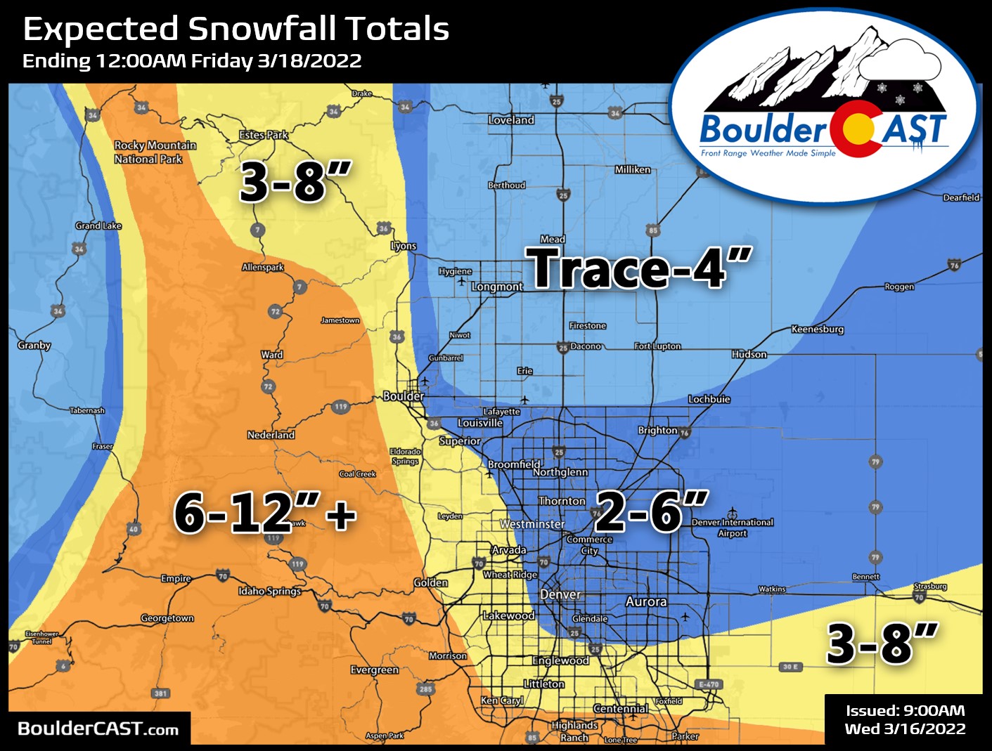
Snowfall amounts
Given all the avenues for boom or bust scenarios to unfold tonight, we are expecting quite a range of snow totals across the Denver Metro area and the higher elevations with this storm. There’s no question about it: melting will be a serious issue with a warm ground following the spring-like temperatures we had on Tuesday and the near-freezing surface air temperatures when the snow is falling tonight. We’re particularly concerned about the northerly flow keeping things above freezing northeast of Boulder and north of Denver where getting much snow to stick could be a challenge. For most of the Denver and Boulder area though, anywhere from 2 to 10″ of sloppy snow can be expected (highest south and southwest). In the higher terrain where snow will begin earlier and melting will be much less of an issue, 6-12″ is our forecast range with locally higher amounts possible (if not likely) in parts of Jefferson County and maybe near the top of the Palmer Divide. Our snowfall forecast map for the event is shown below. The gradient in snow amounts is expected to be most dramatic in eastern Boulder County with uncertainty very high in this region as well!
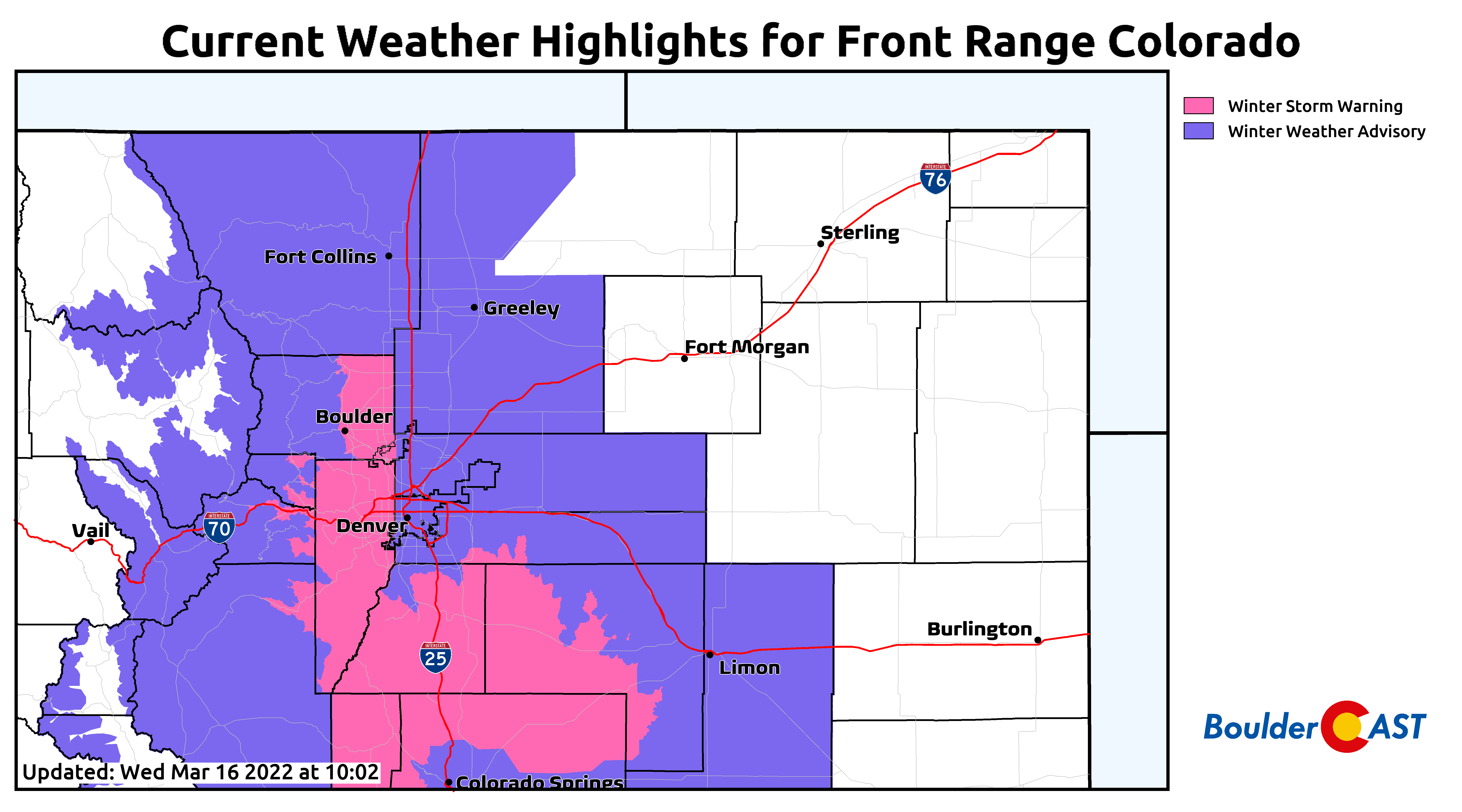
The National Weather Service has issued a Winter Storm Warning for the western Denver Metro area (including Boulder and Golden), the Jefferson County Foothills, and the Palmer Divide. Technically Longmont is also included in the warning, but that’s somewhat laughable. The rest of the Front Range from Denver to the Wyoming Border is under a Winter Weather Advisory for now (but may be upgraded to a Warning at some point). These winter highlights run through 12:00PM on Thursday.
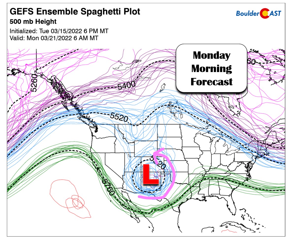
The next big one?
Regardless of how tonight’s mess ultimately pans out, Mother Nature may already have an encore performance in the works for early next week as some models are consistently showing a major Four Corners low pressure slamming the central and southern Rockies Sunday night into Monday. Still five days out, this is obviously quite uncertain for now, but confidence is inching up that something will happen early next week, possibly of the same or even higher caliber than the storm knocking down our door right now.
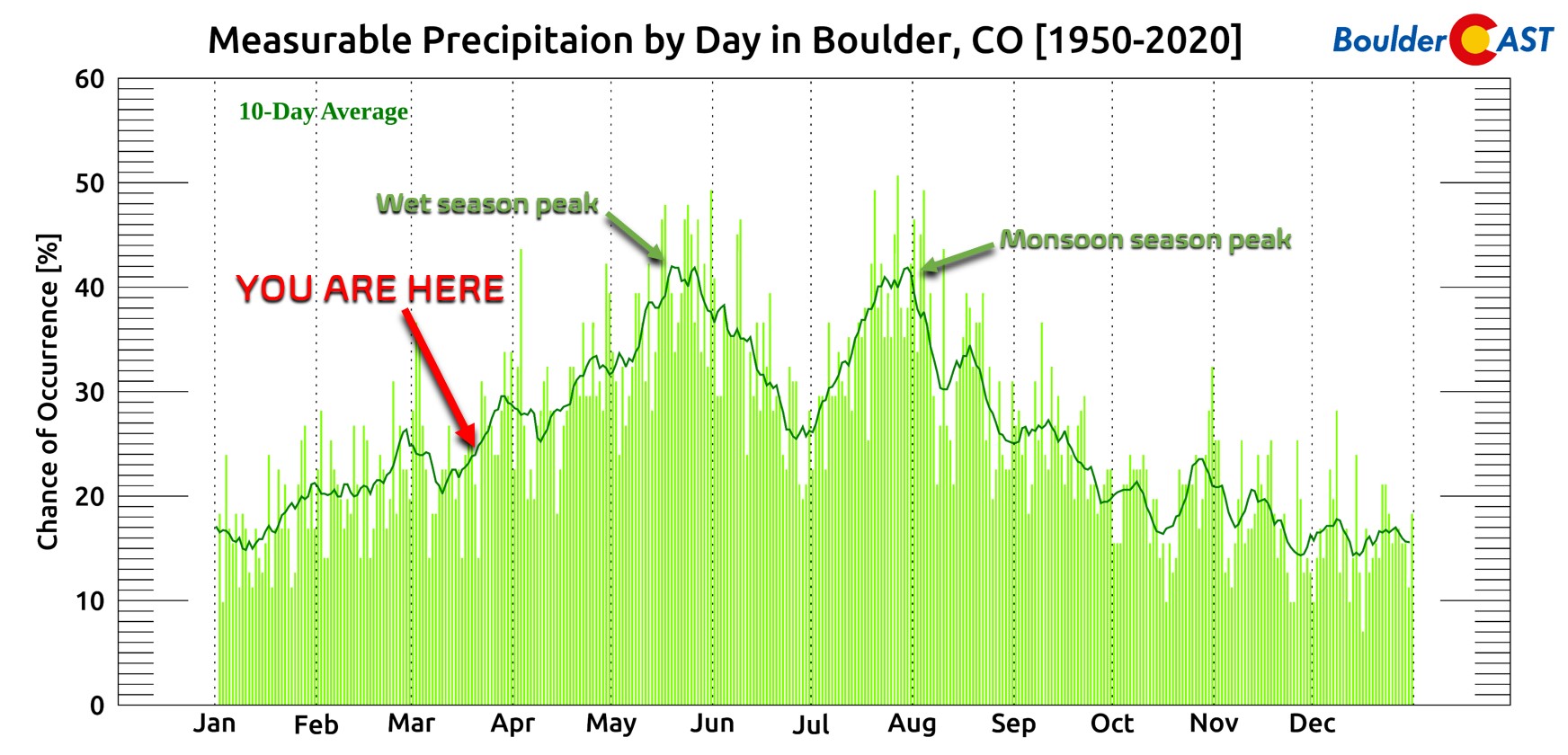
This type of moisture infusion into storms is mostly only possible in the transitional seasons (spring and fall). The pitifully warm and dry excuse of an autumn in 2021 offered up nothing of this magnitude for us in northeast Colorado. We’re excited to be forecasting big, juicy storms again across the Front Range right as we move into the wettest time of the year!
That’s all for now. We expect things will be a lot wetter and slushier by this time tomorrow!
Get BoulderCAST updates delivered to your inbox:
Help support our team of Front Range weather bloggers by joining BoulderCAST Premium. We talk Boulder and Denver weather every single day. Sign up now to get access to our daily forecast discussions each morning, complete six-day skiing and hiking forecasts powered by machine learning, first-class access to all our Colorado-focused high-resolution weather graphics, bonus storm updates and much more! Or not, we just appreciate your readership!

Enjoy our content? Give it a share!


You must be logged in to post a comment.