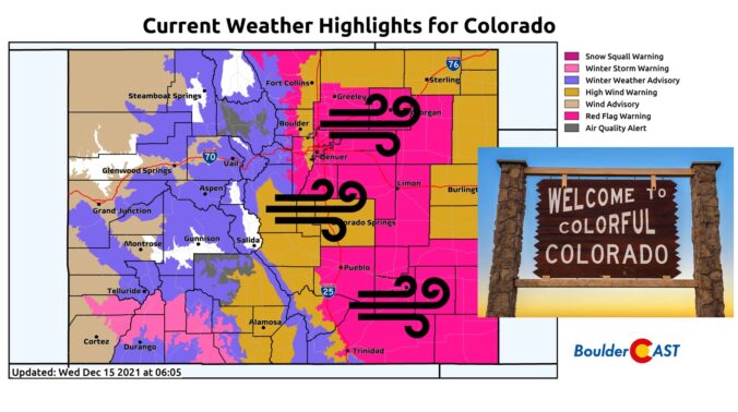
Things are about to start rocking and rolling across the Front Range as a potent storm system rapidly races across Colorado early this morning. Here’s the latest update on the timing of everything, where the snow squall is headed, potential snow amounts, and the all-important wind speed outlook.
We discuss Boulder and Denver weather every single day on BoulderCAST Premium. Sign up today to get access to our daily forecast discussions every morning, complete six-day skiing and hiking forecasts powered by machine learning, access to all our Front Range specific weather models, additional storm updates and much more!

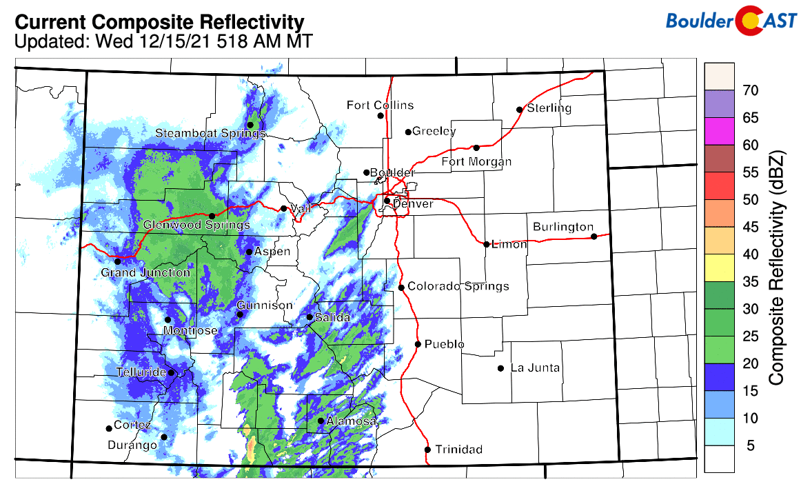
It’s eerily calm early this morning, which is only fitting considering what is about to blow through the area in just a few hours’ time! Our storm system is moving in right on-schedule with a strong cold front and associated snow squall pushing through central Colorado right now. It will reach Boulder and Denver right around sunrise so make any final preparations NOW!
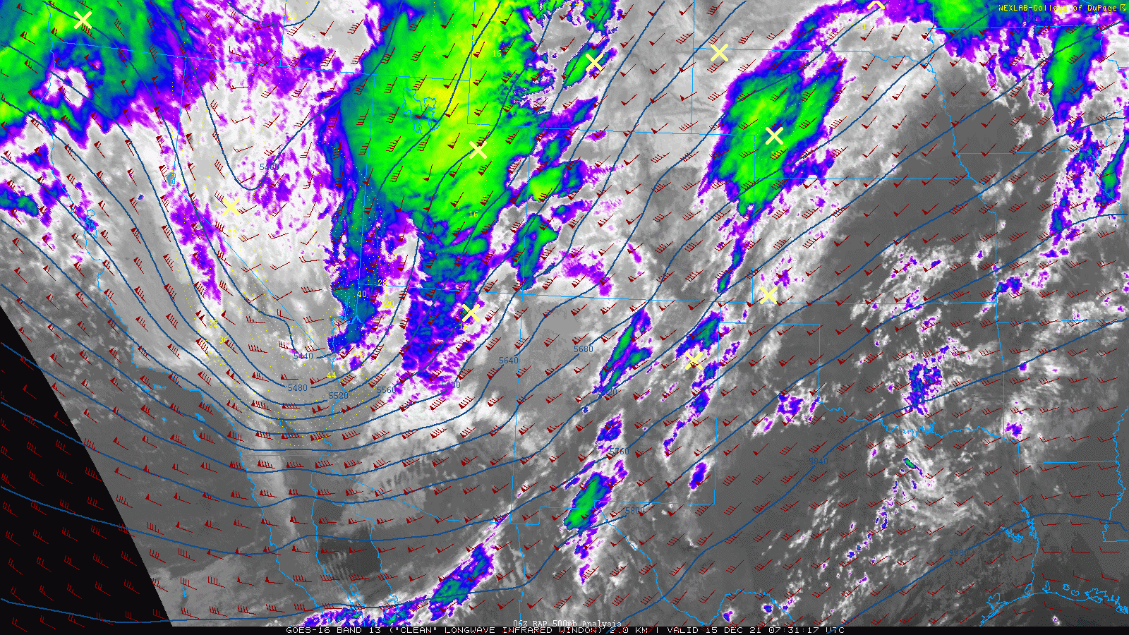
As we have been discussing, the initial impact everyone will feel will be the frontally-forced line of convective showers. This snow band, though moving extremely rapidly, has snowfall rates up to 2″ per hour and wind gusts up to 45 MPH. This will create hazardous travel in the High Country this morning with brief whiteout conditions. The band headed right for Boulder and Denver has prompted a Snow Squall Warning, the winter-time equivalent of a Severe Thunderstorm Warning, along I-70 near Vail and Georgetown as dangerous travel conditions exist.
We’re still not exactly sure what this squall line will do when it starts to descend down from the Continental Divide into the Denver Metro area. It likely will lose some of its punch from the downsloping effects, but may not completely fizzle out. The HRRR model-simulated radar and p-type animation below shows minimal impacts for the lower elevations as the squall line breaks up for the most part.
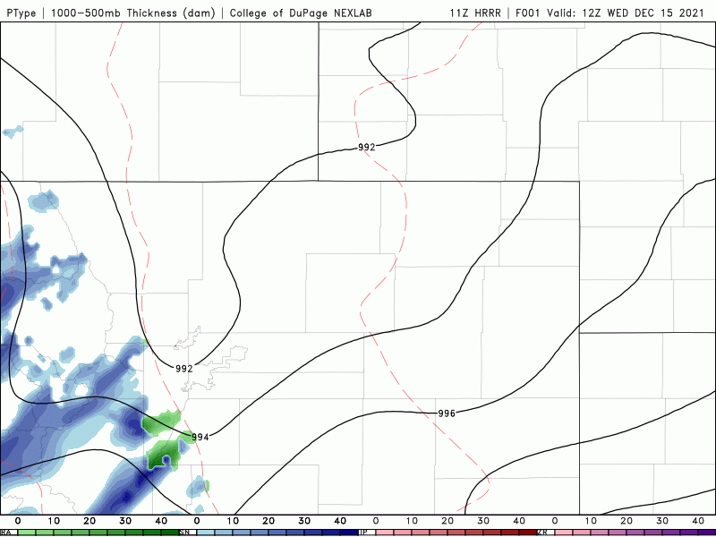
HRRR model-simulated precipitation for early Wednesday morning showing the squall line dissipating as it reaches the Denver area, but that may not happen!
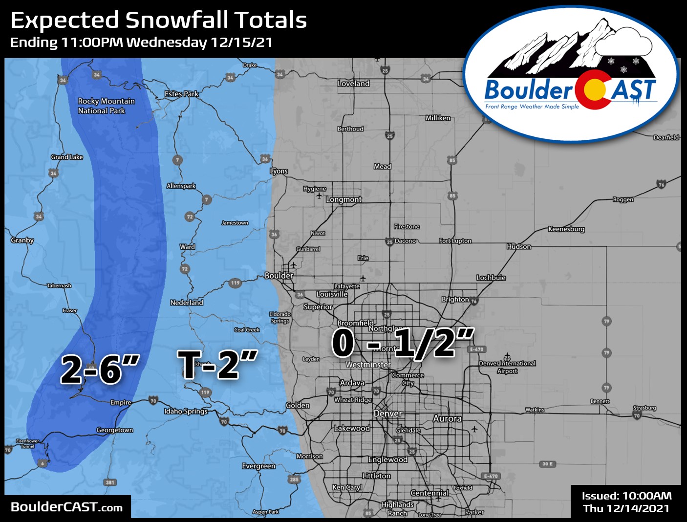
However, confidence is low on this feature. It’s warm enough across the Plains right now that any precipitation would begin as rain. As the front moves in and the higher precipitation rates cause evaporative and dynamic cooling, rain should quickly change to a heavy wet snow in this band if it survives. Nonetheless, snowfall isn’t the main concern today, so we shall not focus on it too much. Look for a brief window this morning for rain and snow showers (6:30AM to 8:30AM) with a dusting or less of snow accumulation and maybe up to 1 to 2″ in the Foothills. Our snowfall forecast map issued yesterday still looks very good.
On to the main course: the wind! Everything remains on-track for a damaging bora wind event for the entire Denver Metro area today. Winds will pick up immediately following the front/precipitation band and will continue through the late afternoon and even the evening in the higher terrain. Models have come in ever-so-slightly lower on wind speeds early this morning, but don’t let your guard down. We’re still expecting many hours of dangerous and damaging winds across the area. The latest run of the HRRR model (below), for example, has Boulder exceeding High Wind Warning criteria (58+ MPH gusts) every single hour from 9AM to 6PM, with peak gusts around 93 MPH!
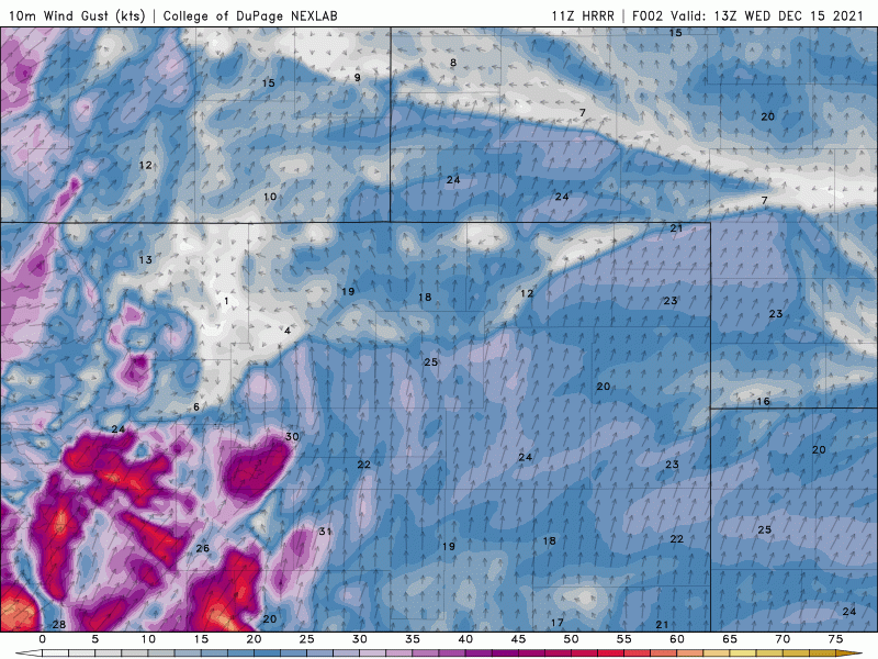
Latest wind gust forecast animation from the HRRR model. Note that these values are in knots, not MPH
The absolute strongest winds will occur from the late-morning through mid-afternoon. The worst of this storm will be in and near the Foothills — Boulder, Rocky Flats, and Golden are all squarely in the bullseye today for the absolute strongest gusts. Locations along and east of Interstate 25 will have lesser winds, but we’re still talking peak gusts of 50 to 70 MPH which can definitely cause damage as well.
The graphic below compares two high-resolution model forecasts during the height of the wind event today around the lunch-hour. Though the model on the left (HRRR) is clearly more intense than the model on the right (NAM-NEST), both have a similar spatial distribution of the winds with a focus west of Interstate 25.
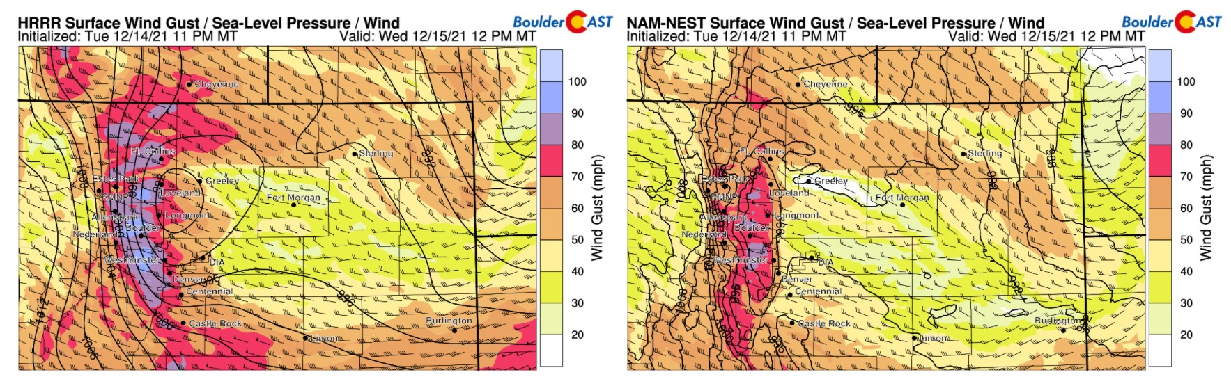
Near-surface wind gust forecast from the HRRR (left) and NAM-NEST (right) models for 12PM today
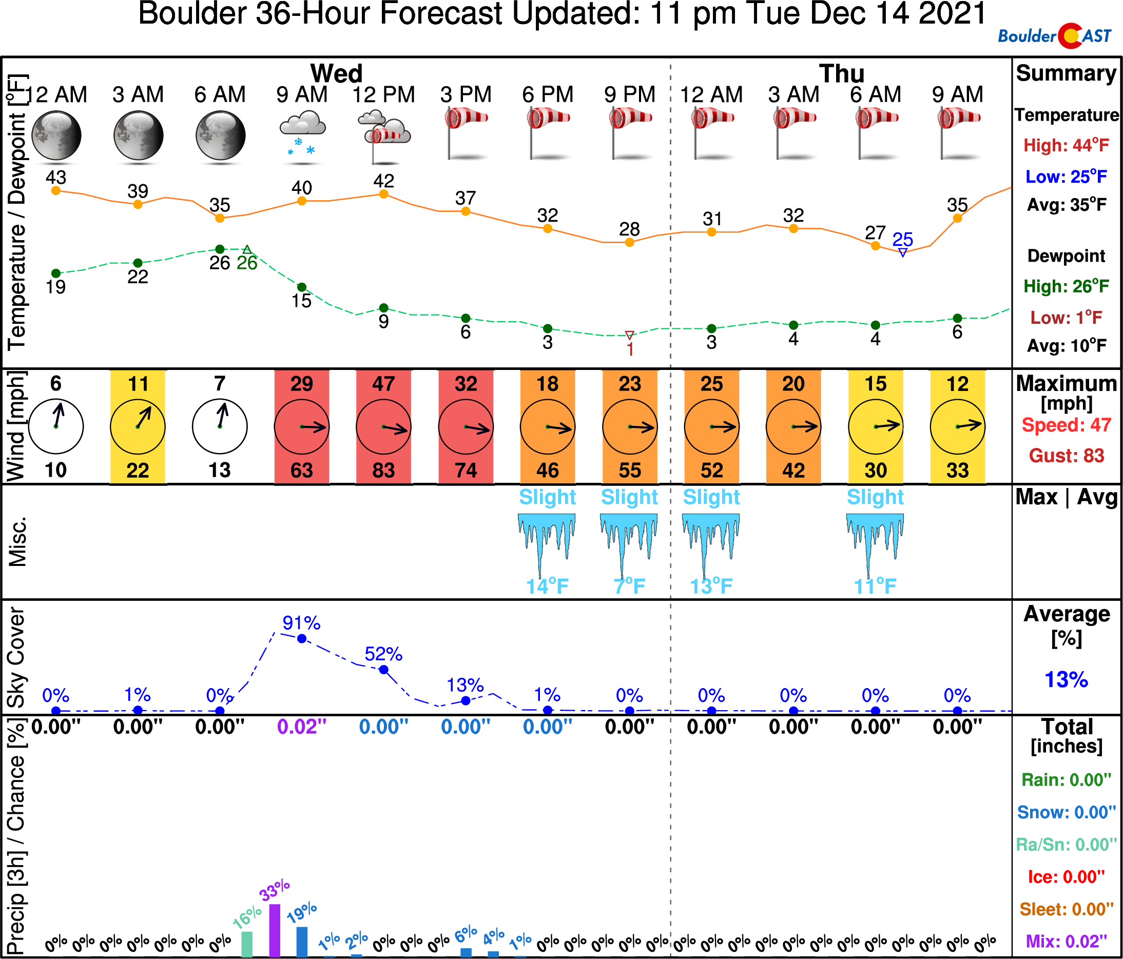
Here’s our latest timeline forecast for Boulder. 65 to 90 MPH gusts are no joke and would be the strongest wind event for the city in years.
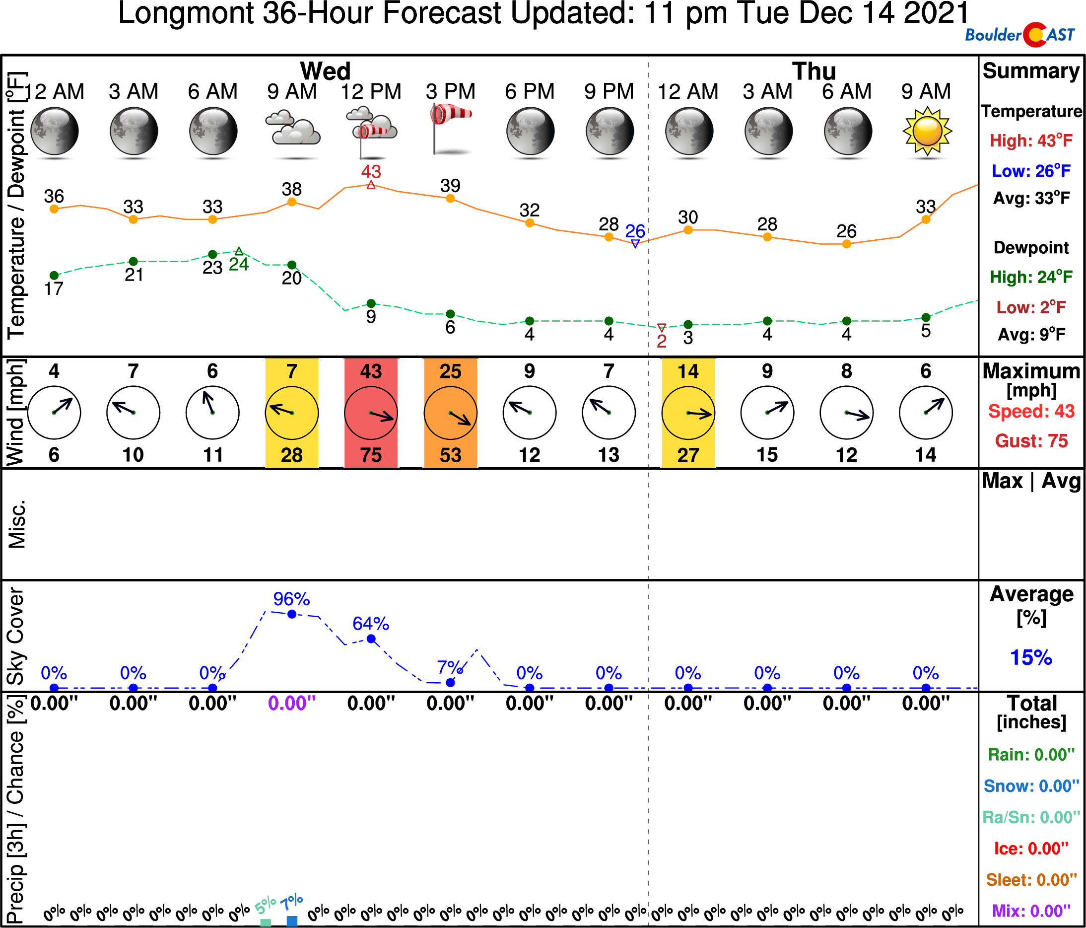
Things will also be very gusty in Longmont today with peak gusts of 60 to 80 MPH expected there.
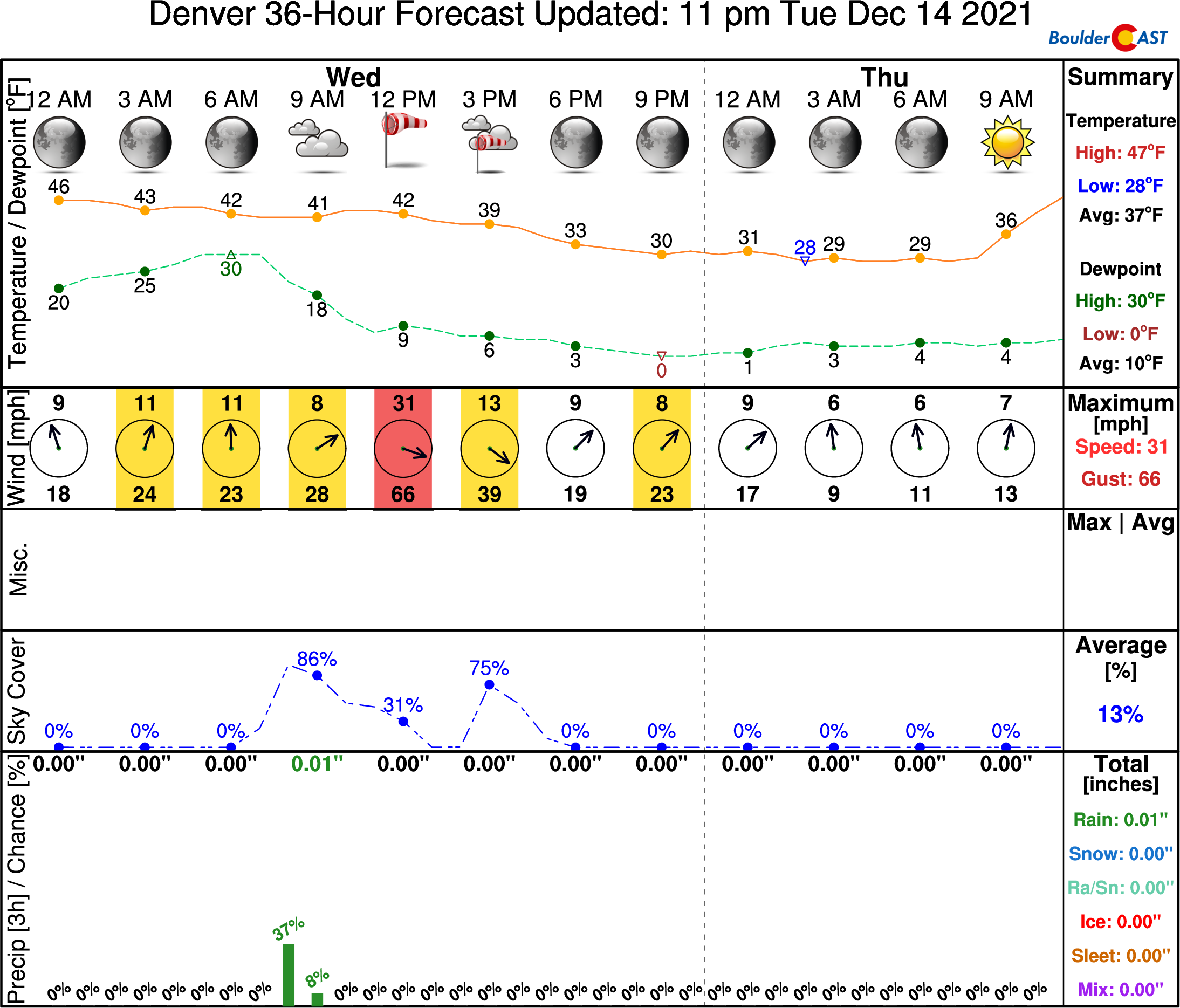
Here is Denver’s timeline where 50 to 70 MPH gusts are expected (lower gusts the further east you go). There is some concern that flights in and out of DIA could get halted today, but we just don’t know the criteria that might go into a decision like that, so make sure to check your flight status closely for potential delays and cancellations.
Finally, here are some subjective probabilities for peak wind gusts occurring today in Boulder and Denver.
Probability of a least one wind gust exceeding various thresholds within 5 miles of BOULDER:
- 60 MPH: 100%
- 70 MPH: 95%
- 80 MPH: 80%
- 90 MPH: 40%
- 100 MPH: 30%
Probability of a least one wind gust exceeding various thresholds within 5 miles of DENVER:
- 60 MPH: 90%
- 70 MPH: 65%
- 80 MPH: 25%
- 90 MPH: 5%
- 100 MPH: <1%
Colorado sure is living up to its “colorful” nickname right about now….
Batten down the hatches and let’s hope this storm blows through on the lower end of model guidance. And please, don’t even think about doing anything that could create a spark outdoors. Fire danger is extreme today. Good luck, everyone!
Share this critical weather information with your friends & family:
Help support our team of Front Range weather bloggers by joining BoulderCAST Premium. We talk Boulder and Denver weather every single day. Sign up now to get access to our daily forecast discussions each morning, complete six-day skiing and hiking forecasts powered by machine learning, first-class access to all our Colorado-centric high-resolution weather graphics, bonus storm updates and much more! Or not, we just appreciate your readership!


You must be logged in to post a comment.