Another boring week of weather is set to unfold across the Front Range as Colorado remains trapped in a dry and stagnant weather pattern. Sunshine and unseasonable warmth will be the story this week across the area as a result. While there was some potential for things to change this upcoming weekend, that no longer appears to be the case. There’s no rain (or snow) anywhere in pipeline — heck there’s barely any clouds! Let’s take a look…
This week’s highlights include:
- A shortwave ridge and a persistent influx of dry air from the southwest will lead to a quiet weather week across the Front Range
- Temperatures climb steadily through the week and eventually encroach upon record levels by Thursday and Friday
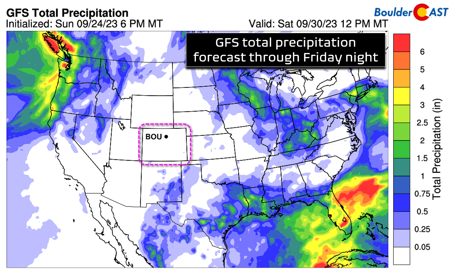
- No chance of any rain or snow in the state over the next five days (or more)
- A Pacific trough will dig into the Great Basin during the upcoming weekend, but the latest model guidance suggests it will not fully reach Colorado
- Southwest flow increases this weekend as the trough nears with warm/dry conditions persisting — an uptick in winds should lead to elevated fire danger
DISCLAIMER: This weekly outlook forecast is created Monday morning and covers the entire upcoming week. Accuracy will decrease as the week progresses as this post is NOT updated. To receive daily updated forecasts from our team, among many other perks, subscribe to BoulderCAST Premium.

Go Premium, get all the perks.
Daily Forecast Updates
Get our daily forecast discussion every morning delivered to your inbox.
All Our Model Data
Access to all our Colorado-centric high-resolution weather model graphics. Seriously — every one!
Ski & Hiking Forecasts
6-day forecasts for all the Colorado ski resorts, plus more than 120 hiking trails, including every 14er.
Smoke Forecasts
Wildfire smoke concentration predictions up to 72 hours into the future.
Exclusive Content
Weekend outlooks every Thursday, bonus storm updates, historical data and much more!
No Advertisements
Enjoy ad-free viewing on the entire site.
Nothing but sun
Late September into mid-October is historically one of the nicest times of year in the Front Range. The intense heat of summer dissipates and overnight temperatures grow chillier as the nights become longer than the days. During this time of transition, lengthy stretches of mild and dry weather are typical across Colorado. As you might have guessed where this is going, that is exactly the weather situation shaping up for the week ahead. ..
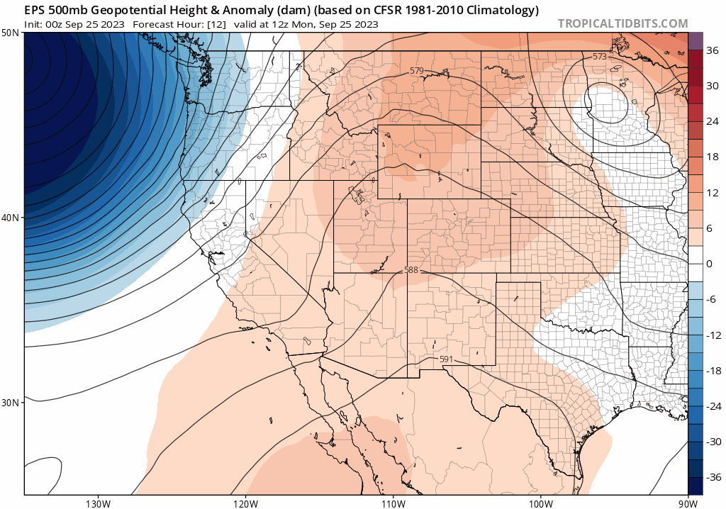
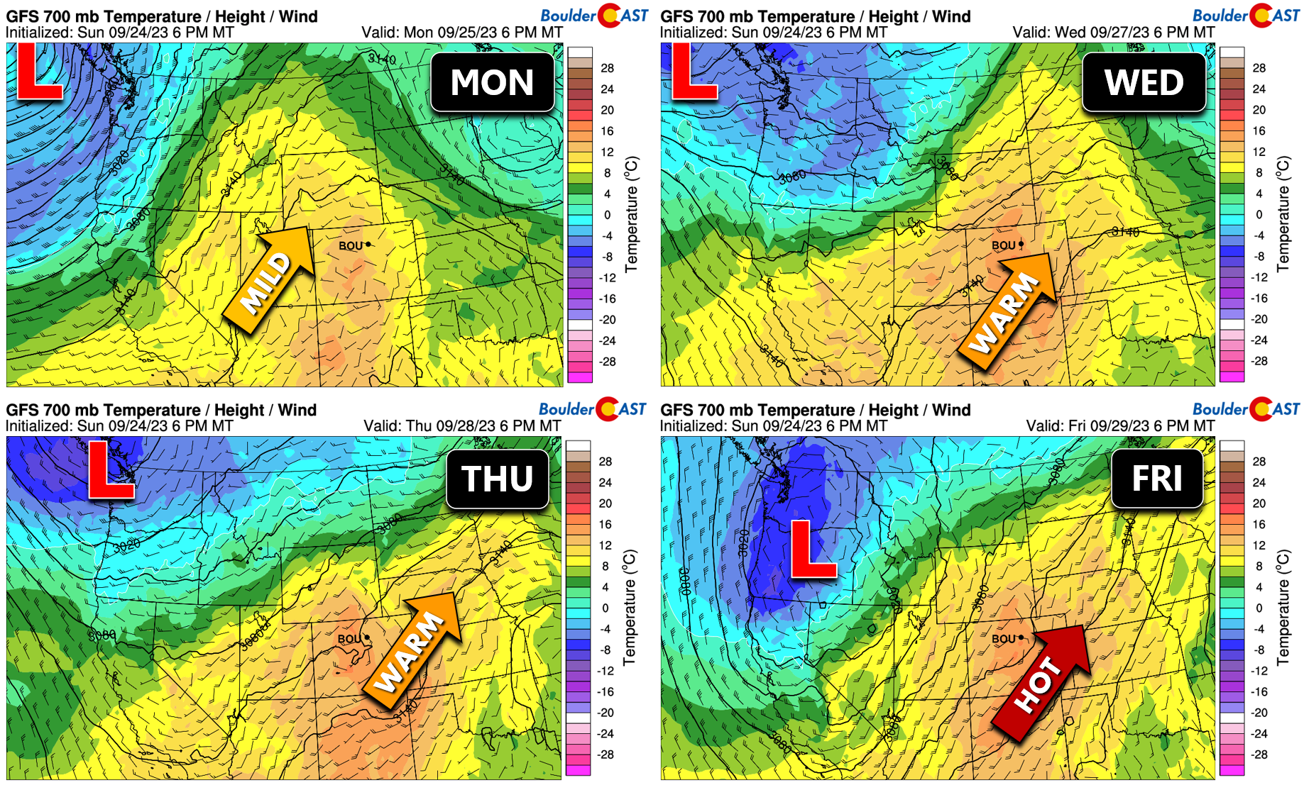
The main reason for the anticipated gorgeous weather this week is a lack of any major weather-makers across the Rockies. Broadly speaking, Colorado will remain parked beneath a slow-moving shortwave ridge axis through Thursday morning, while at the same time a trough stalls out in the Pacific Northwest leading to plentiful unsettled weather up there. Late in the week, our ridge will begin to shift east in the Midwest allowing the trough to move eastward as well. Exactly how far this trough moves east will determine whether or not we see cooler and unsettled weather for the upcoming weekend. More on that in a moment…
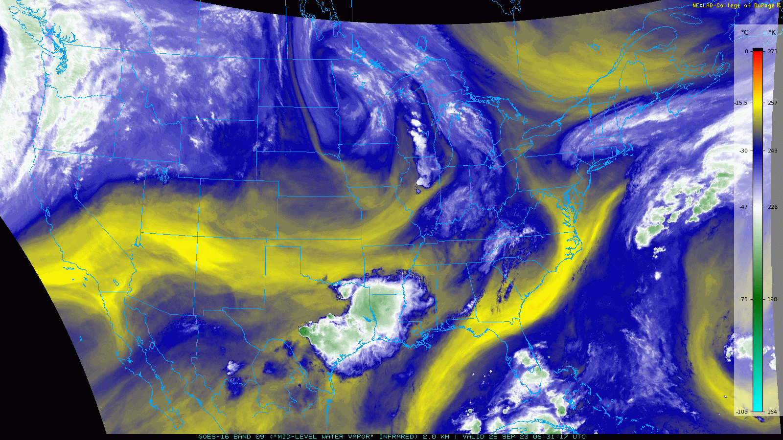
As of early Monday morning, GOES-East water vapor imagery shows bountiful dry air across Colorado, with even drier air sitting upstream across the Desert Southwest and southern California. The pipeline of parchedness will continue to flow into Colorado through the week. This dearth of moisture combined with subsidence from the overhead ridge will lead to almost completely cloud-free conditions across Colorado for the next few days. You will be hard-pressed to find a cloud through Wednesday in our area, though there could be a few fair-weather cumulus spawning over the higher terrain during some of the afternoons.
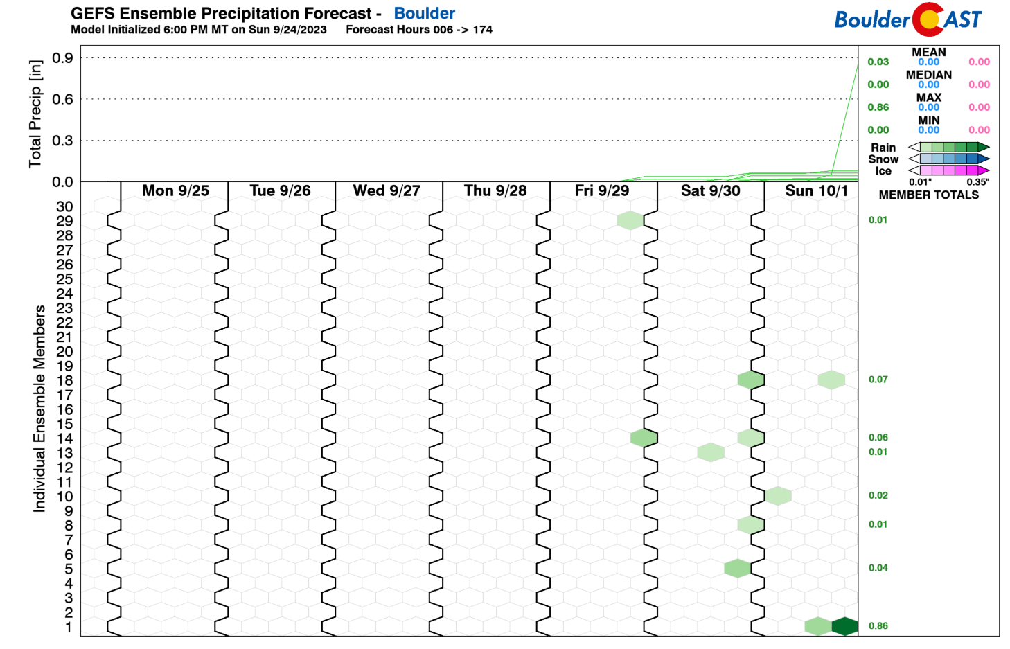
Once we head into Thursday and Friday, the chance of seeing some clouds will increase, but precipitation chances remain essentially non-existent across the Centennial State under continued dry southerly flow. Yes, we will be 100% dry through at least Friday under this quiet weather pattern. Any outdoor plans you have this week will go off without a hitch, at least one related to the weather.
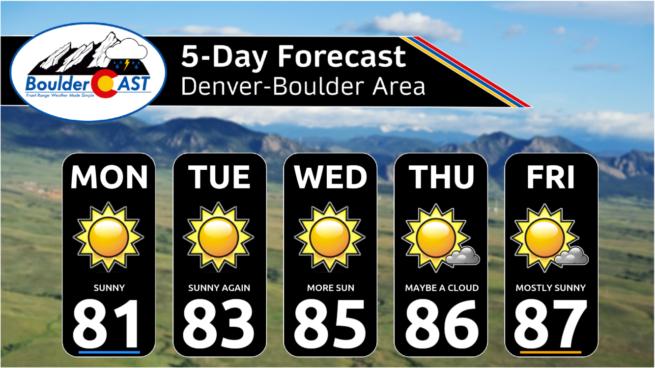
As for temperatures, they will remain above normal through the week and in fact slowly trend upwards with each successive day. At the 700mb level (near 10,000 feet elevation), temperatures increase from around 11°C Monday afternoon to around 14°C by Wednesday, then finally peaking around 16°C on Friday. With completely sunny skies and no cold fronts to speak of, these lofted readings will translate into high temperatures rising from the lower 80s Monday towards the middle to even upper 80s by week’s end.
Our five-day forecast is brimming with sunshine and unseasonable warmth!
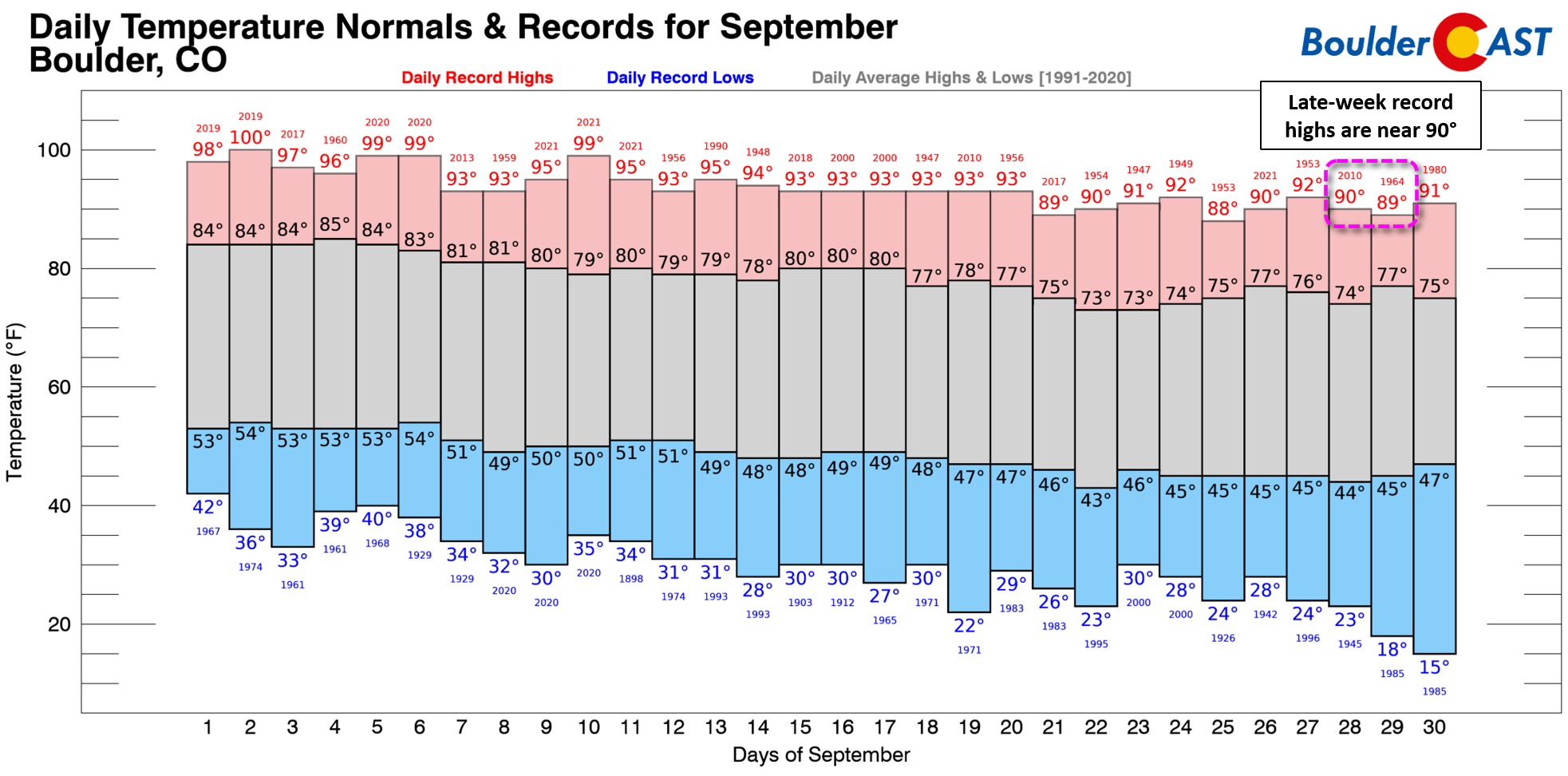
Temperatures will be especially torrid near the tail-end of the week when existing daily record highs will be encroached upon. We’re not currently forecasting any new records, but we will be in the ballpark (or at least the parking lot of said ballpark).
Little to no change for the weekend
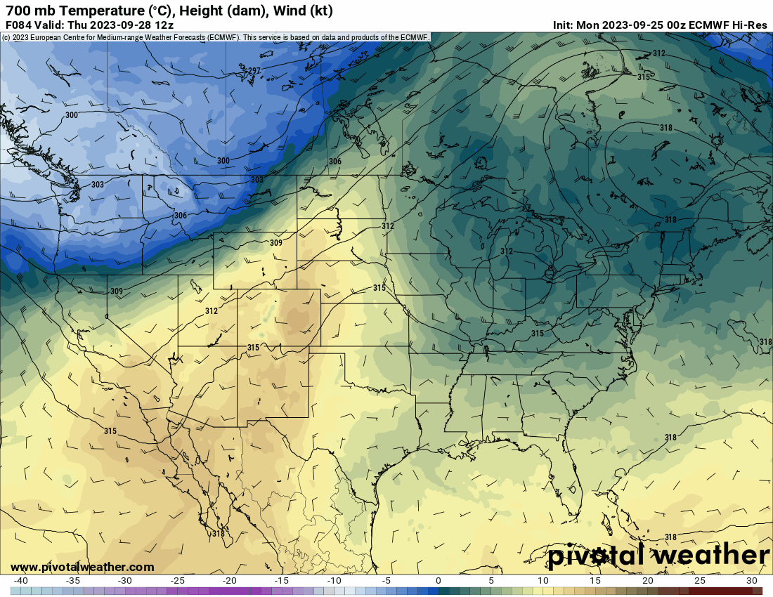
As we move into the weekend, the weather setup across the West becomes more active, but also more uncertain. We know that the Pacific Northwest trough will dig further southward into the United States, but exactly how much progress it makes is still not clear. Previously models were showing a more progressive open trough getting all the way through Colorado during the upcoming weekend which would have brought cooler and unsettled weather to our area. However, this initial projection has changed with most models now forming a broad cut-off low across the Great Basin this weekend. As you can see in the European model forecast animation below, this closed-low is forecast to stall out with eastern Colorado remaining nicely nestled in strong (and of course warm) southwest flow.
With this in mind, we’re not likely to see much change in our weather for the upcoming weekend with temperatures remaining atypically warm in the 82 to 88° range but with stronger winds mixed in as the jet stream nears closer. Winds will be particularly blustery in the Mountains, but some of this wind will make it into the lower elevations as well. Fire danger will be on the increase as a result, especially across southeast Colorado.
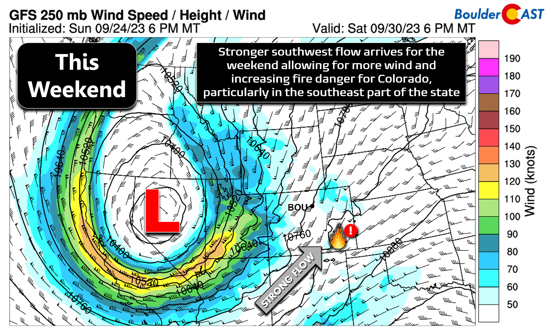
There could be a few thunderstorms over the weekend, even some severe ones, across parts of far eastern Colorado. However, pending any major shifts in the track and evolution of the cut-off system, the Front Range will remain entirely dry. Whether you like it or not, there remains no rain or snow in our medium-range forecast. Heck, there are barely any clouds.
Eventually whatever is left of that Pacific cut-off low will kick east across the Rockies. This looks to happen sometime next week, perhaps around Wednesday or so. At that point we should see temperatures drop back down out of the 80s as well as a meager, yet non-zero, chance of precipitation.
Finally, make sure to get your submission in for our 9th Annual First Snowfall Contest which closes to entries on Monday October 2nd.
Enjoy the sunshine this week! ☀️ ☀️ ☀️
Forecast Specifics:
Monday: Sunny and warm with highs in the lower 80s on the Plains with upper 60s in the Foothills.
Tuesday: Continued sunshine and warmer with highs in the lower to middle 80s on the Plains and in the lower 70s in the Foothills.
Wednesday: Sunshine prevails with highs reaching the middle 80s on the Plains with lower 70s in the Foothills.
Thursday: A weak frontal passage in the morning may come with a few clouds, but otherwise temperatures rebound nicely by afternoon into the middle 80s on the Plains with lower 70s in the Foothills.
Friday: Mostly sunny and borderline hot with temperatures climbing into the middle to upper 80s. Winds may be breezy in the afternoon with elevated fire danger, especially southeast of Denver. Temperatures top out in the middle to upper 80s on the Plains with lower to middle 70s in the Foothills.
Weekend: Continued warm and dry weather is expected with mostly sunny skies and temperatures staying in the 80s. Winds may increase during the daytime hours leading to elevated fire danger, especially for areas southeast of Denver.
DISCLAIMER: This weekly outlook forecast is created Monday morning and covers the entire upcoming week. Accuracy will decrease as the week progresses as this post is NOT updated. To receive daily updated forecasts from our team, among many other perks, subscribe to BoulderCAST Premium.
Go Premium, get all the perks.
Daily Forecast Updates
Get our daily forecast discussion every morning delivered to your inbox.
All Our Model Data
Access to all our Colorado-centric high-resolution weather model graphics. Seriously — every one!
Ski & Hiking Forecasts
6-day forecasts for all the Colorado ski resorts, plus more than 120 hiking trails, including every 14er.
Smoke Forecasts
Wildfire smoke concentration predictions up to 72 hours into the future.
Exclusive Content
Weekend outlooks every Thursday, bonus storm updates, historical data and much more!
No Advertisements
Enjoy ad-free viewing on the entire site.
Get BoulderCAST updates delivered to your inbox:
Enjoy our content? Give it a share!


You must be logged in to post a comment.