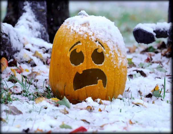
The first potential accumulating snow event of the season is knocking on the door! A quick-moving system will scoot across Colorado late Wednesday night into Thursday bringing a period of precipitation to the area. Temperatures will be just cold enough for rain to change to snow across most of the Front Range and likely will accumulate on grassy surfaces a tad. Weather models remain torn on exactly how much snow will fall with this system as there are signs that some more moderate snow bands may form. We discuss the latest developments on the storm and provide our snowfall forecast map.
At a Glance:
- Dry and quiet Wednesday, but our next storm system is lurking across the Pacific Northwest and it arrives quickly tonight!
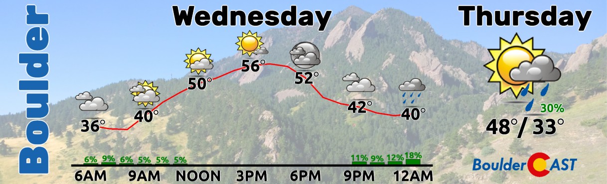
- Rain showers will change to snow in the early morning hours Thursday as temperatures drop into the low to middle 30s behind a cold front
- Snow could be moderate at times, possibly bringing minor impacts to the Thursday AM commute
- Our current forecast calls for a trace to 2″ in the Boulder-Denver area, 1-4″ in the Foothills and 3-8″ in the Mountains
- Any lingering rain/snow showers will clear out Thursday afternoon with highs in the 40s and late-day sunshine
- Watch for a widespread freeze Thursday night into Friday morning — some areas still have not had one!
Be prepared for the winter ahead!
As a special offer to kick off BoulderCAST’s 8th straight year of forecasting Front Range winter weather, use the promo code EARLYBIRD to save 25% on an annual BoulderCAST Premium subscription.
We discuss Boulder and Denver weather every single day on BoulderCAST Premium. Sign up today to get access to our daily forecast discussions every morning, complete six-day skiing and hiking forecasts powered by machine learning, access to all our Front Range specific weather models (including smoke forecasts), additional storm updates and much more!

The first snowfall of the season? Yes. Well, probably!
Avigorous but petite storm system approaches Colorado from the Pacific Northwest — can you feel the winter weather on the way? After a dry day Wednesday, this system will arrive with strong mid-level forcing and a cold front after midnight Wednesday night with the ingredients coming together for a brief, but possibly intense 8 to 12-hour period of precipitation across the Denver Metro area Thursday morning. As you can see in the NAM 500mb vorticity forecast animation below, the storm system will track from Washington into Texas over the next 36 hours, clipping across western Colorado in the process as a rather small closed-low pressure.

After a decent day on Wednesday while we rest between storm systems, there could be a few spotty rain showers around late Wednesday evening to get the action started, but things really don’t get interesting until the cold front arrives after midnight and into the early morning hours Thursday!
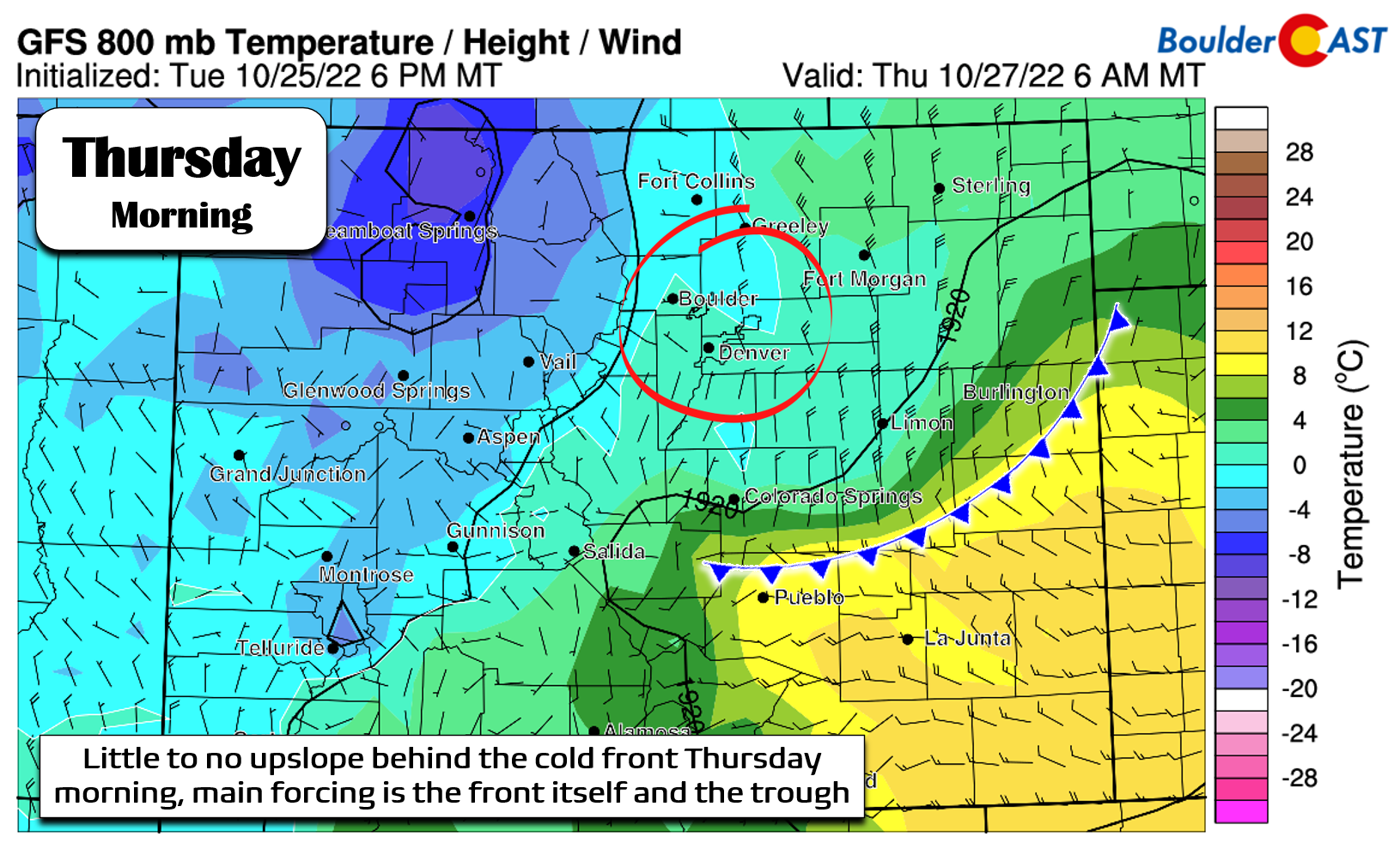
The cold front itself and the converging winds it offers will be the main mechanism for precipitation across the Front Range this time around. There’s not really much upslope to speak of behind the front unfortunately — not at the surface nor at the level of the terrain — just some pesky northerly winds…
On paper, this system should bring many Front Range cities their first accumulating snow of the 2022-23 snow season! However, we have two main concerns about things right now. Let’s briefly touch on both…
Concern #1: Temperatures (both air & ground)
It’s still early in the snow season and that means temperatures are more likely to be a problem for snow — and this event is no exception. It’s not uncommon to get Arctic intrusions from Canada into the Front Range this time of year. In fact, this happened exactly two years ago during a fortunate snow event which gave the firefighters an upper-hand on containing the Cameron Peak, East Troublesome and Lefthand wildfires in October of 2020:
Two years ago today an Arctic airmass engulfed the Front Range shattering early season cold records and dropping a foot of fluffy snow in #Boulder. This snowstorm helped quell the Cameron Peak, East Troublesome and Lefthand wildfires which were active at the time. #COWX pic.twitter.com/8tUiTtYvyd
— BoulderCAST Weather (@BoulderCAST) October 25, 2022
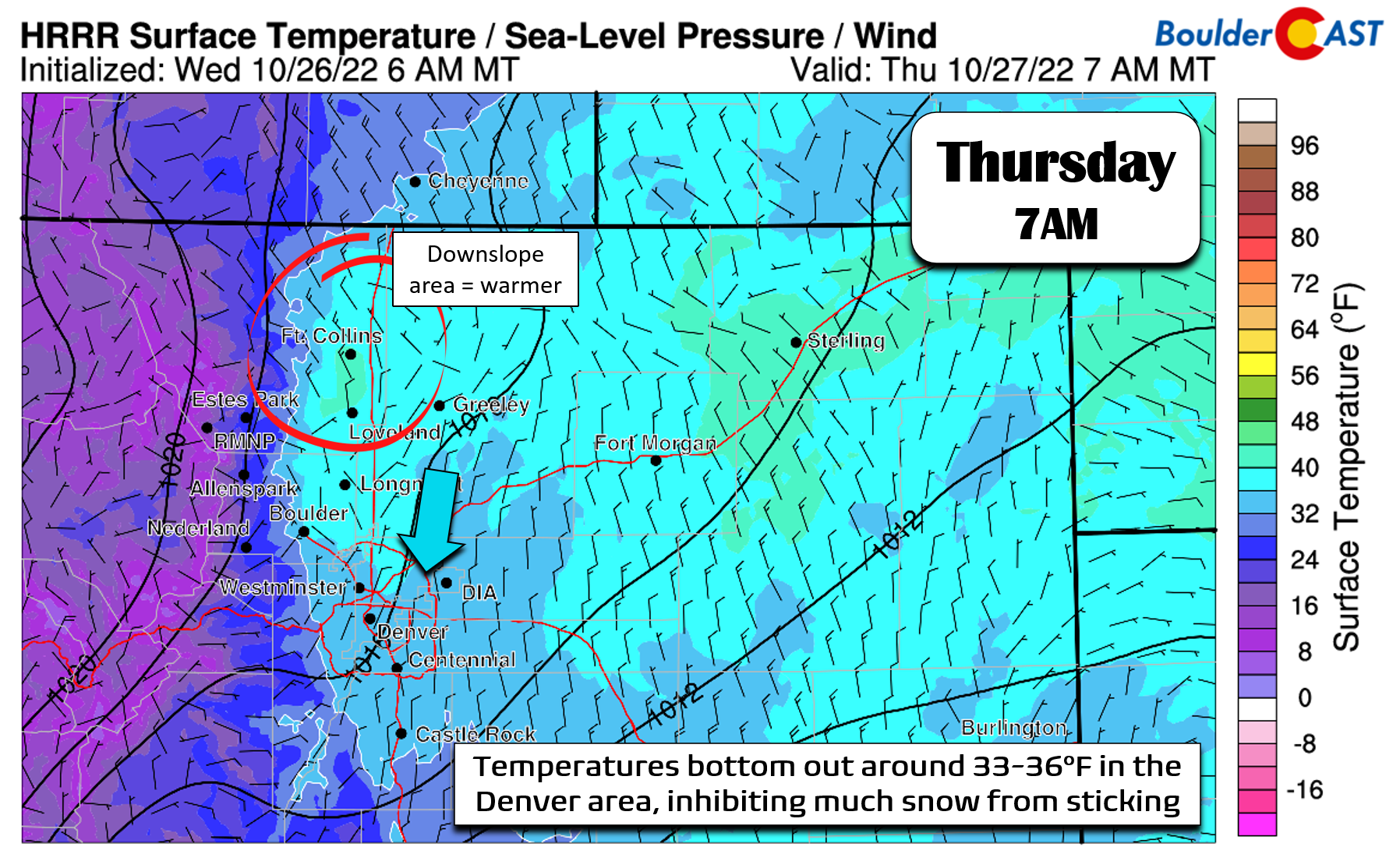
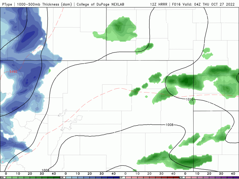
However, this system is not of that breed — it has origins over the comparatively mild Pacific Ocean and is way too small to pull down any truly cold air from central Canada with it. As the front moves past, temperatures will fall quite a bit tonight, eventually bottoming out in the low to middle 30s Thursday morning. High-resolution models show a spread of 33 to 37°F across the Boulder-Denver Metro by sunrise on Thursday. While cold enough to support snow for many of us, these above freezing temperatures will lead to a lot of melting, especially when considering the warm ground present right now. Furthermore, areas from Longmont northward are likely to remain a little warmer than this as downslope comes off the Foothills and Cheyenne Ridge much of the time there. Thus, we’re expecting little to no snow at all up that way.
The lack of sufficiently cold air gives us worry about the potential for snow and snow accumulation with this system. Generally, we do expect a change-over from rain to wet snow to occur between 2AM and 6AM Thursday morning for much of the area as temperatures cool throughout the lower atmosphere. However, what falls versus what sticks will be challenging, and will largely be dependent on our second concern below…
Concern #2: Potential for a burst of heavy precipitation
While most global models are showing a broad and modest brush of 0.1 to 0.25″ of precipitation across the area from this system (half rain, half snow), recent high-resolution model runs are telling a different story — one with potentially double or even triple the amount of precipitation falling in the Denver area Thursday morning due to a slow-moving band of intense precipitation trailing behind the front (see below).
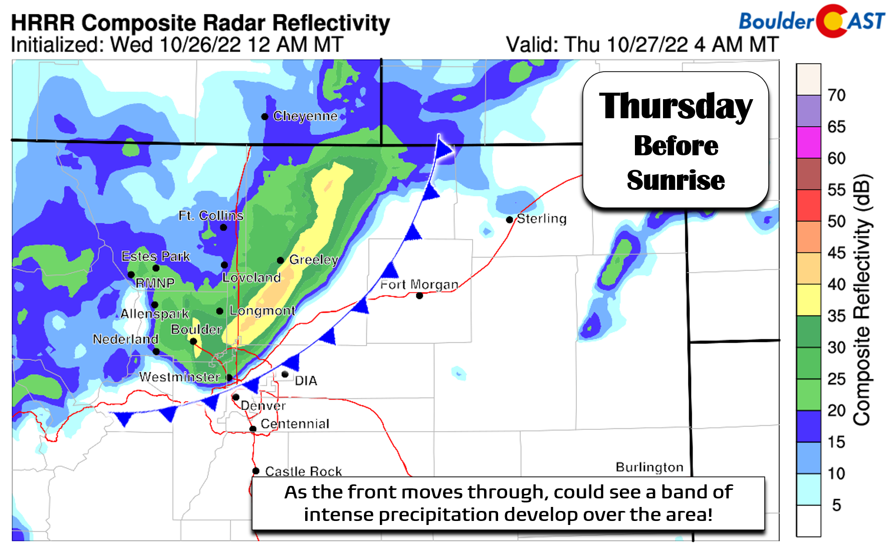
Watch as this potential intense band of rain and snow sits over the Denver Metro area most of Thursday morning in the simulated radar-type forecast animation below:
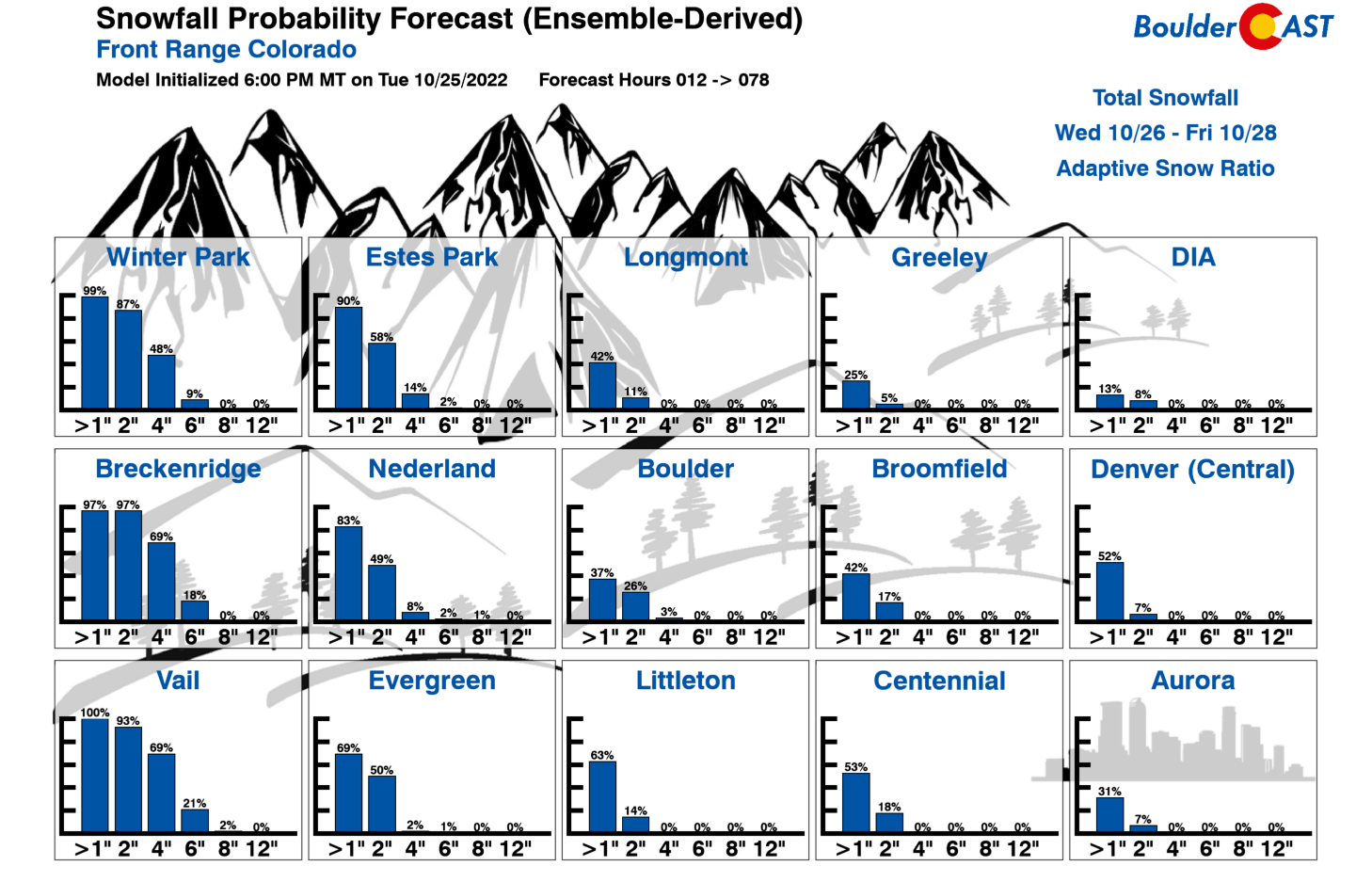
This is indeed a curious prediction from the HRRR model — it’s not exactly clear how this intense band is being generated. There is the front around and some instability, but really nothing which should produce a snow band of this intensity moving this slow. The jet stream is completely removed from the equation making things all the more dubious. As you might expect, with this type of band, the slushy snow could really pile up across the area early Thursday, smack in the middle of the morning commute to boot! Here’s a look a the bullishly high snowfall forecast from the same model. It depicts roughly 2-5″ in Boulder and Denver, but 5-12″ in the Foothills and Mountains.

So how much snow?
The HRRR model’s strong suggestion that something more significant may unfold tonight definitely gives us pause. It’s not always the most accurate model of course, but it’s rarely completely out to lunch in these situations. At the time of writing late Wednesday morning, with such a rift across the models, we’re stuck between a rock and a hard place in terms of giving guidance on forecast snowfall amounts. In our eyes, it’s either going to be a very minor event with most places picking up nothing to 1″, or something larger with booming snow totals in the Foothills and up to a few inches in Denver. At this point, the lack of upslope, warm temperatures and lack of clarity from the models….combined with our past experience, all has us leaning towards the lower end of things, more in-tune with the broad-scale models and ensembles. As an example, our latest Snowfall Probabilities tell the low-end tale for sure — with minimal chances for any lower elevation city to exceed 2″ of snow and just shy of a coin-flip whether 1″ is reached.
Our snowfall forecast map, all uncertainties withstanding, is shown below. This covers all snow falling late Wednesday night into Thursday early afternoon. Plan for possible minor impacts to the morning commute, especially if you’re driving in the higher terrain. Any snow that sticks would mainly accumulate as slush on the grassy surfaces, keeping the roadways just wet. Snow may mix back to rain as Thursday morning progresses, especially north of Denver. Eventually everything will end north to south by early afternoon with even some sunshine possible later in the day. Highs will be chilly, though, with many areas failing to get out of the 40s on Thursday. Keep an eye out for what will likely be the most widespread freeze of the season Friday morning. There are still a few locations that have not dropped to or below freezing yet!

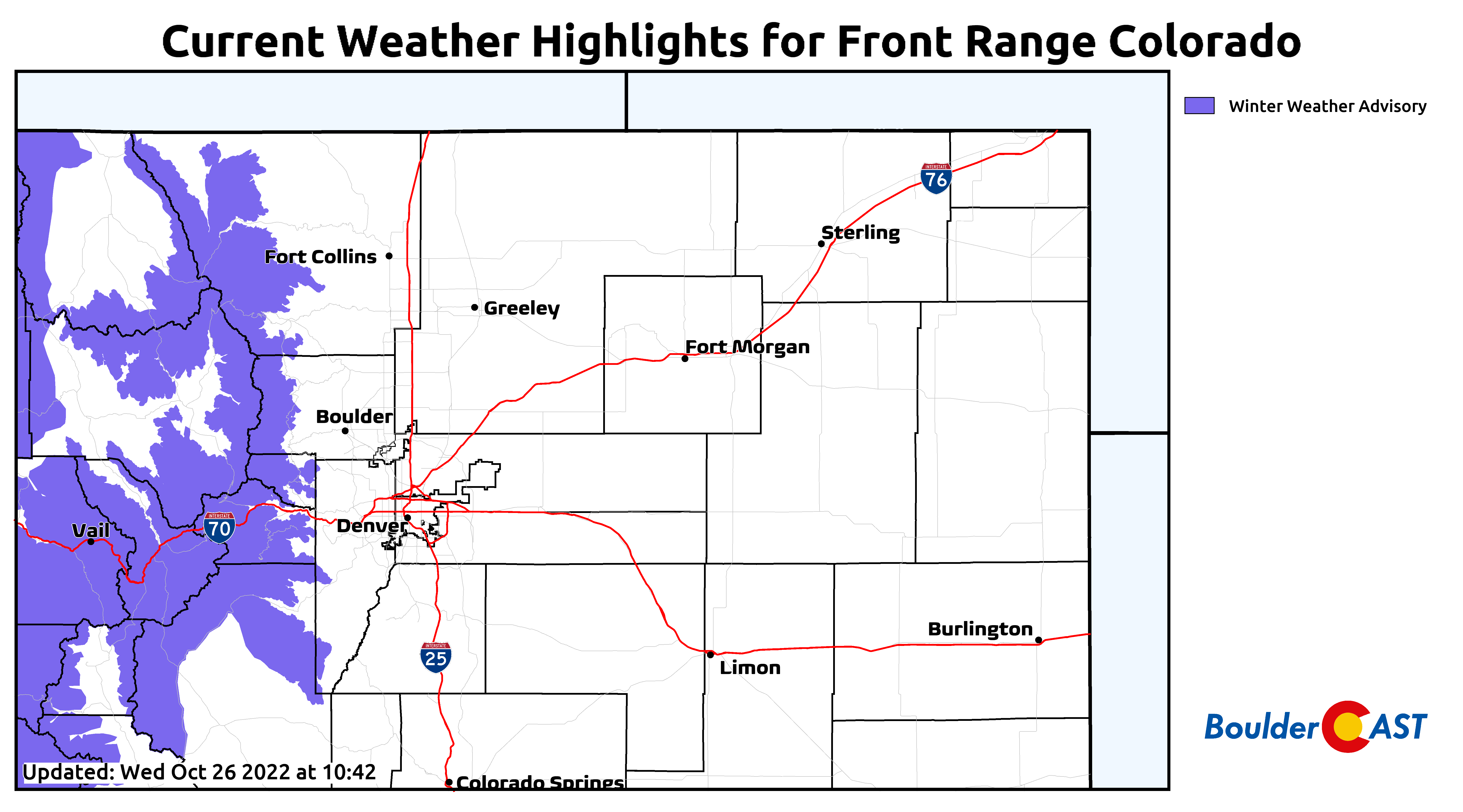
Right now Winter Weather Advisories are in effect but only for the Mountains above 9,000 feet elevation to the west. Depending on how things develop in the models later today and tonight, it’s conceivable that we may see these advisories expanded to cover the Foothills and dare we say the Denver area considering the potential overlap with the Thursday morning commute. That’s not very likely at all, but you never know!
We’ll continue to monitor the situation and provide an updated snowfall forecast map later on Wednesday evening — if there is any more clarity from the models, that is. Otherwise, we’ll just ride this one out as is. Stay tuned, follow us on Facebook and Twitter for live updates and be sure to subscribe:
Get BoulderCAST updates delivered to your inbox:
Enjoy our content? Give it a share!


You must be logged in to post a comment.