Thanks to several occurrences of localized jet-forced banded snow, the month of February saw stark differences in snow amounts across the Metro area. We recap the month and also take a look at the current standings in the 3-Month Snowfall Forecast Contest.
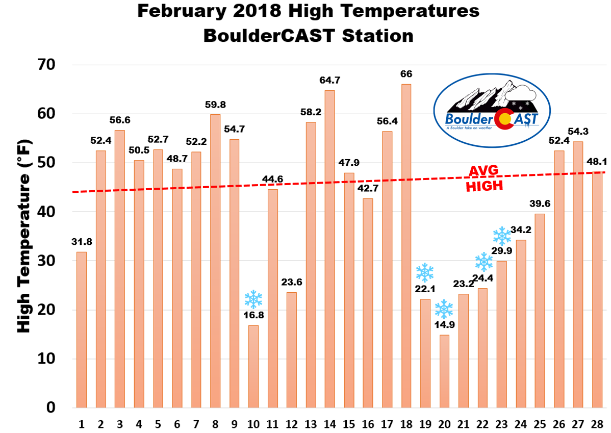
February 2018 began as expected, with a warm and dry weather pattern (ridge) dominating Colorado and the western United States, not unlike what transpired last year. However, frequent northern-track systems broke down the ridge just enough to allow several Arctic air-masses to spill through eastern Colorado’s backdoor. The time-line of high temperatures at BoulderCAST Station below shows that we actually had more warm days than cold ones. However, the cold days were REALLY cold with highs more than 30 degrees below normal. Boulder even set two new record low temperatures on the 20th and 21st (-6 and -4 degrees, respectively). The net result produced an average monthly temperature for February some 2 to 4 degrees below normal across the Front Range.
The monthly departure from normal temperature map below tells the story quite well. The shallow Arctic intrusions that invaded eastern Colorado never made it over the Continental Divide. The higher elevations and Western Slope (including the ski resorts) saw temperatures 2 to 6 degrees above average during the month.
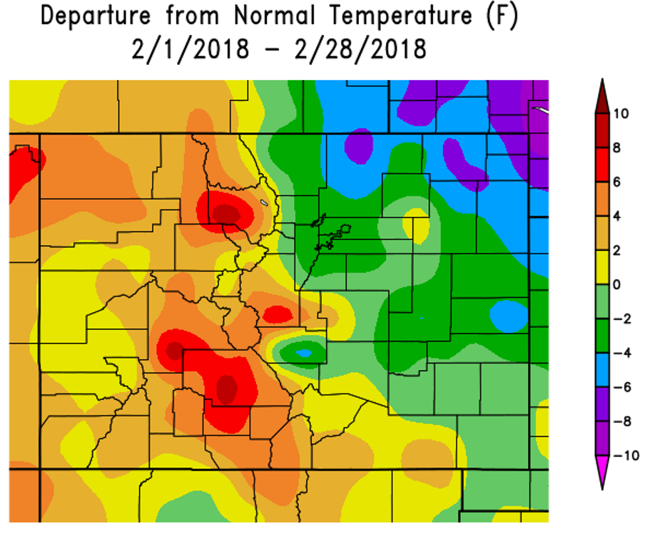
Departure from normal temperature for the month of February.
As far as precipitation, there was quite the disparity in amounts across the Metro area. Two of the three “major” snow events during the month were jet-related and produced fairly localized snowfall for the northwestern Denver area, including Boulder, Longmont, Broomfield, and Loveland. As a result, while Boulder recorded 18.5″ of snow in February (above normal), Denver saw just 6.2″ (below normal). Those shallow Arctic cold fronts, which are a staple of La Niña winters, produced another six days with freezing drizzle for Denver International Airport during the month, bringing the total so far this winter to eleven, which surely is a new record.
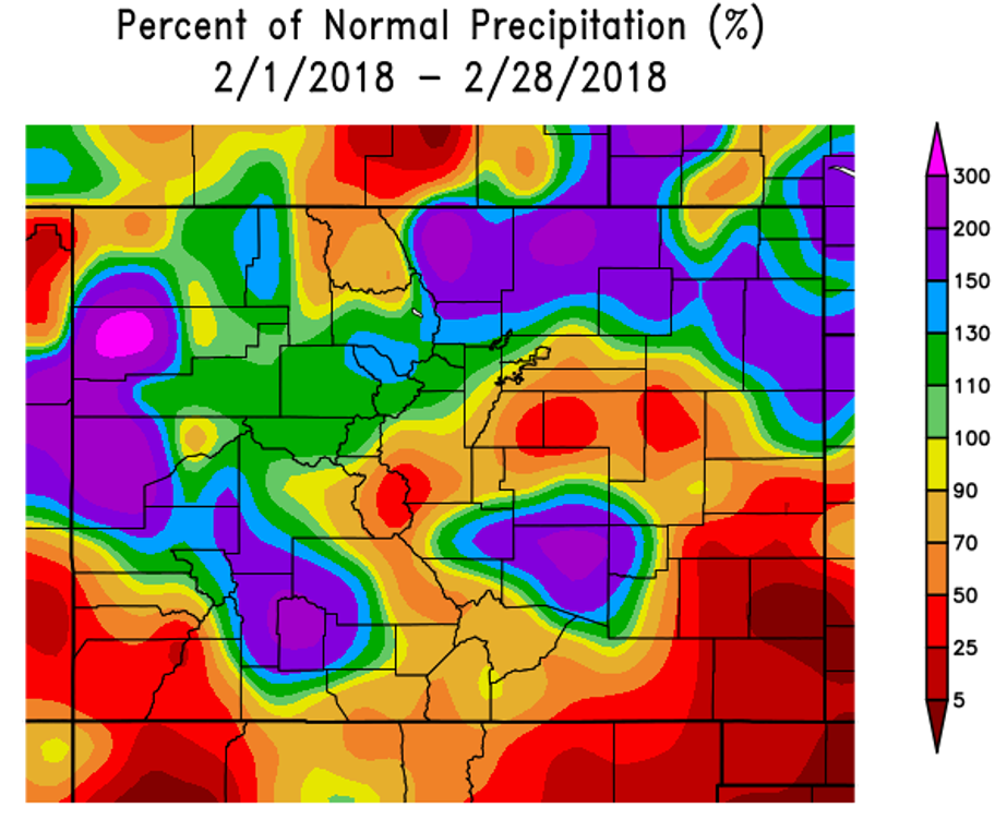
Percent of normal precipitation for the month of February.
FEBRUARY 2018 SUMMARY
| Avg High | Avg Low | Mean T (Departure) | Max T | MinT | Tot Snow (Departure) | |
|---|---|---|---|---|---|---|
| Boulder | 46ºF | 19ºF | 33ºF (-3ºF) | 66ºF | -6ºF | 18.5" (+4.4") |
| Denver | 44ºF | 15ºF | 30ºF (-3ºF) | 69ºF | -7ºF | 6.2" (-1.5") |
.
As you might expect, the lack of moisture in many locations has caused drought to expand across the state. The United States Drought Monitor says 71% of Colorado is now experiencing a drought, up from just 3% five months ago. With the favoritism in snowfall shown by Mother Nature all winter long, Boulder and Larimer Counties are one of the lucky 29% not included in the drought right now. Denver is, however.
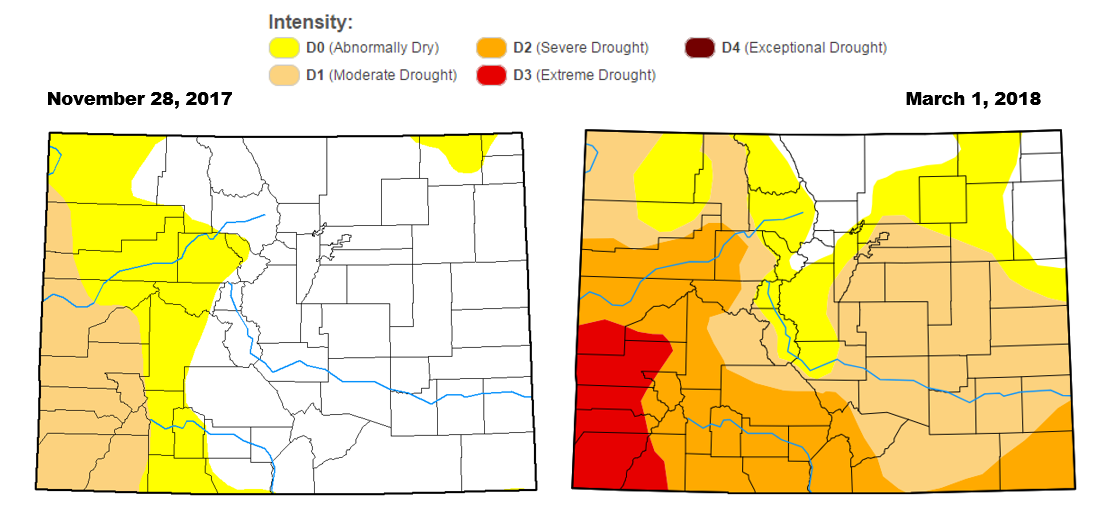
Drought has expanded over the last three to six months across Colorado. Now more than 70% of the state is experiencing drought.
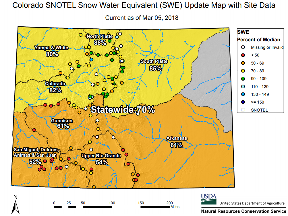
It will come as no surprise to the skiers, but the lack of moisture has caused snowpack to remain below normal statewide. Based on SNOTEL data, we’re sitting at 70% of the climatological median as of yesterday. This is a slight improvement compared to where we were one month ago.
As we discussed in our weekly outlook yesterday, any snowfall in the Mountains over the next five to seven days will be light (see the GFS snowfall forecast map below). We still have another six weeks before snowpack typically reaches its peak and starts to decline. It’s clear the window is now rapidly closing on any chance to make a recovery. As we reiterated six weeks ago, we expect drought to continue to intensify across the state through April. Nothing we are seeing in the mid-to-long range models right now can be classified as “good news” for the farmers, skiers, fire-fighters, or water management folks. The bleak forecast could have tough implications heading into summer….
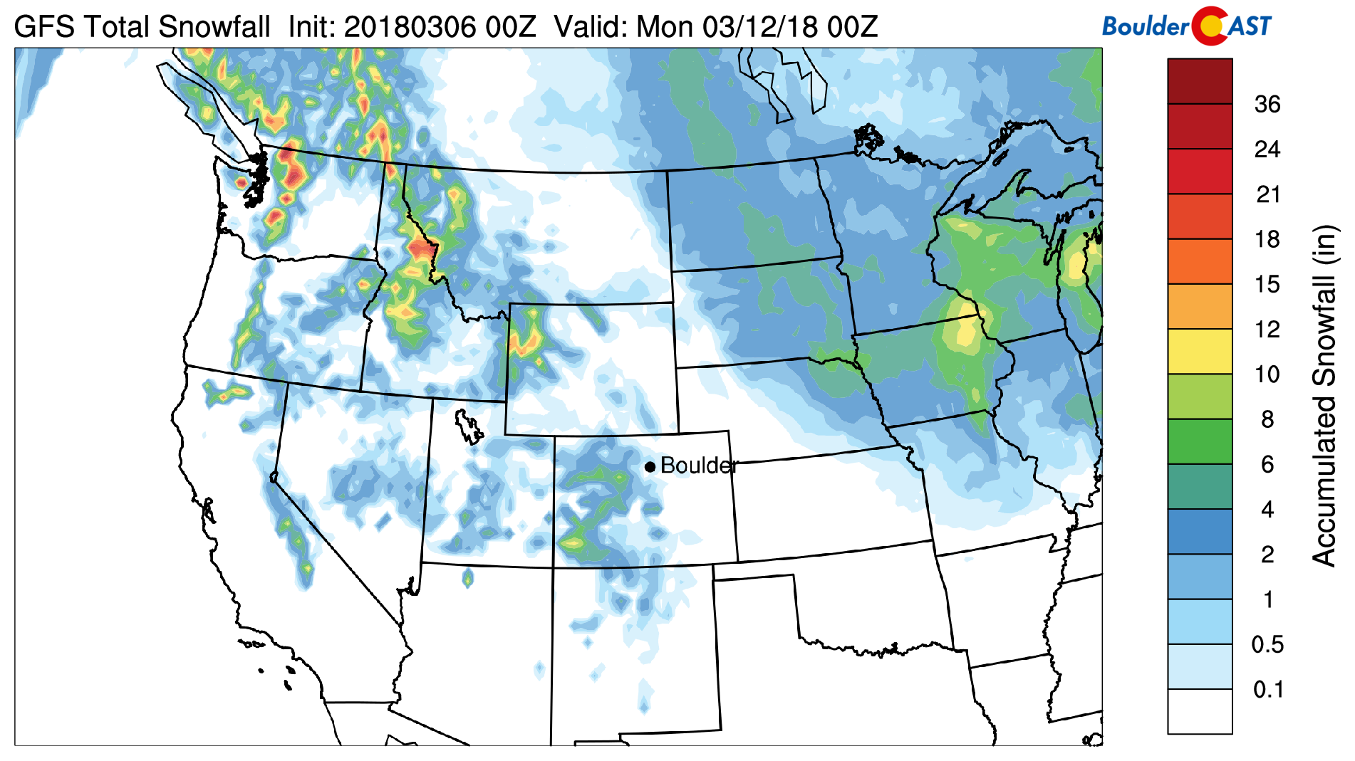
GFS model snowfall forecast through Sunday March 11.
3-Month Snowfall Contest Update
We apologize for the delay in posting any updates to our most recent snowfall contest! It has been a very busy month for our team. There were nearly 100 entries to the contest. The original announcement post will all the information, rules, and scoring details can be found HERE.
The 18.5″ of snow reported in Boulder during the month of February was 4.4″ above the normal value of 14.1″, which was determined as the average of the last 30 years. To the dismay of contest participants, this means February’s snowfall fell into the “Above Normal” category, per below:
SNOWFALL CATEGORIES PER MONTH
- [Much Above Normal] : More than 8″ above normal
- [Above Normal] : 4″ to 8″ above normal
- [Near-Normal] : +/- 4″ from normal
- [Below Normal] : 4 to 8″ below normal
- [Much Below Normal] : More than 8″ below normal
Our biggest snow storm of the month in Boulder, 8.8″, came compliments of February 19th’s jet streak dump.
Locking in the February snow total for scoring, and tentatively accepting the 8.8″ storm as our biggest for the contest, the current score standings are as follows:
- Joan : 10 points
- Five People – 7 points
- Many People – 5 points
Where do you rank? A spreadsheet with all contest entries and current scores can be found HERE.
We’ll continue to provide score updates over the next two months. Contest winners will be announced in early May. As a reminder, we’re giving away a $25 Amazon Gift Card, a T-Shirt, and BoulderCAST Premium subscriptions, dished out as follows:
- Highest Point Scorer: $25 Amazon Gift Card, 6-month subscription to Premium and a BoulderCAST T-Shirt
- Runner-Up: 6-month subscription to Premium
- Anyone Who Scores 14+ Points: 3-month subscription to Premium
- Anyone Who Scores 8-13 Points: 1-month subscription to Premium
- Anyone Who Scores 7 or Less Points: Nothing. Nothing at all…
NOTE: In the event that multiple participants finish with the same point score overall, accuracy of the single-storm snow total will be the tie-breaker. Since there are limited scoring options, this tie-breaker is likely to come into play to determine winners.
.
Share this Colorado weather update:


You must be logged in to post a comment.