The week starts out with a southern track snowstorm for the higher terrain, with only a trace to 1/2″ expected in the Denver Metro. Westerly flow ensues for the remainder of the week, with the potential for gusty winds reappearing around midweek. Outside of a brief period of Chinook warming on Wednesday, highs will remain at or slightly below average through the week ahead and into the upcoming weekend.
Category: Winter Weather (Page 76 of 139)
These posts contain some discussion of the white stuff, whether it be mountain snow pack or a Front Range snowstorm.
The return of winter this past weekend has been well-received by most! Quiet weather starts the week under high pressure with temperatures on the rise and the fresh snow melting. However, expect a gradual trend toward chillier temperatures later in the week. The extended outlook shows signs of an active pattern with snow chances over the weekend and into next week. Let’s take a look!

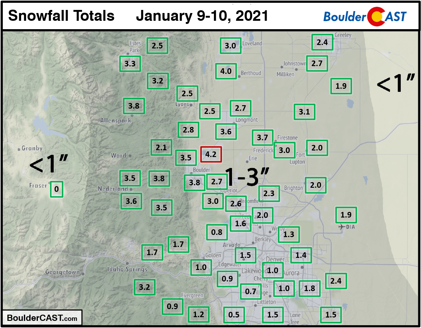
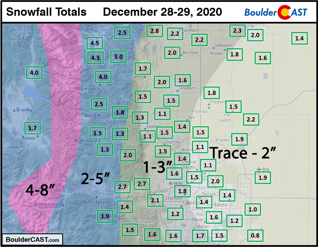
Shown below is our snowfall forecast map with actual storm totals overlaid in boxes. Green boxes indicate that our forecast verified to within one inch of the observed snowfall. Red did not (there are no red).
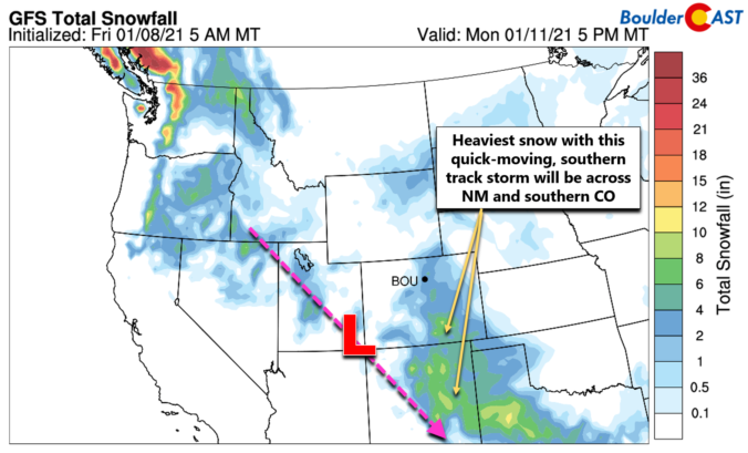
It hasn’t snowed in our area since last year! Well….December 28th to be more precise. However, white stuff is once again in the forecast to begin 2021. A Four Corners low pressure system will spread winter weather back into the Front Range Saturday into Saturday night. Let’s take a look at the timing and potential snowfall amounts in what is sure to be another disappointing snowfall event.
UPDATE (7:00AM Sat 1/9/21): Adjusted snowfall forecast map slightly

The first week of 2021 will not make much of a mark for the Front Range. We’re watching a series of quick-moving but ultimately weak storm systems that will scurry across the Rockies throughout the upcoming week. Mountain snow will be the main story, but we’ve also got a bora wind event in the works for the Plains and possibly some late-week snow as well. Read on for all the details.
December 2020 was marred by a series of weak storm systems that resulted in very little snowfall. This lack of moisture further exacerbated the ongoing drought in Colorado and dashed the hopes of many for a white Christmas in our area. Overall, it was yet another warm and fairly dry month. In fact, this was the sixth month in a row that ended warmer and drier than normal. Here’s a quick and colorful rundown of our weather during December and how it relates to climatology.
Shown below is our snowfall forecast map with actual storm totals overlaid in boxes. Green boxes indicate that our forecast verified to within one inch of the observed snowfall. Red did not (there are no red).
We hope that each and every one of you had a great holiday so far and that it continues into the New Year. This week’s weather will feature light snow accumulations Monday into Tuesday alongside chilly temperatures for much of the week ahead. We’re also watching another system later in the week which could ring in the New Year with more snow. Read on for all the details.

Live View of Boulder

Current Conditions

Live Radar

Recent Premium Posts

This Weekend in Colorado Weather: Early-Season Heat Ramps Up — First 90s of the Year on the Horizon
🌬️ West–northwest flow Thursday supports high‑based convection with gusts to 35 MPH; virga …
BoulderCAST Daily – Wed 06/03/26 | Scattered P.M. storms again as moisture peaks for the week
🌬️ Weak westerly flow aloft today with no major synoptic features nearby; only …
BoulderCAST Daily – Tue 06/02/26 | Storms Reload This Afternoon, But With Noticeably Less Bite
❄️ Monday delivered lots of hail to northeast Colorado, with one supercell tracking …
3-Day Forecast

Trending Content

© 2026 Front Range Weather, LLC
You must be logged in to post a comment.