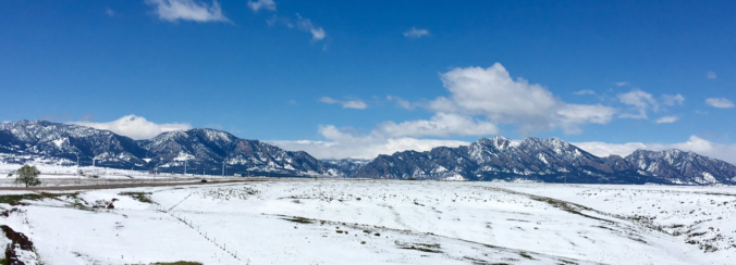
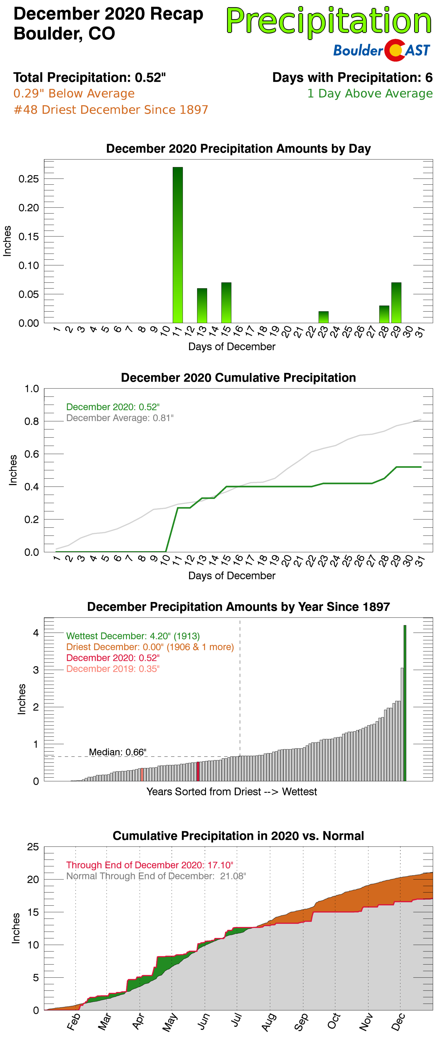
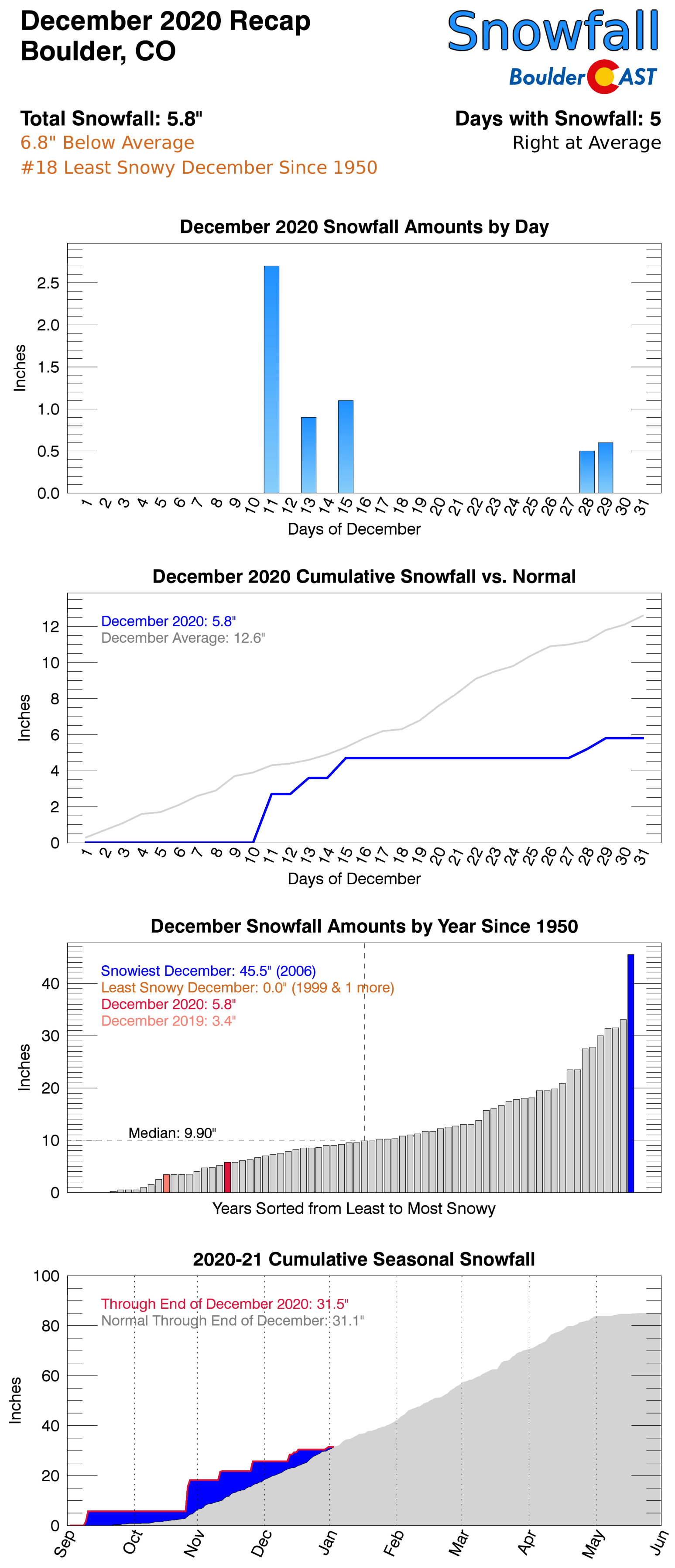
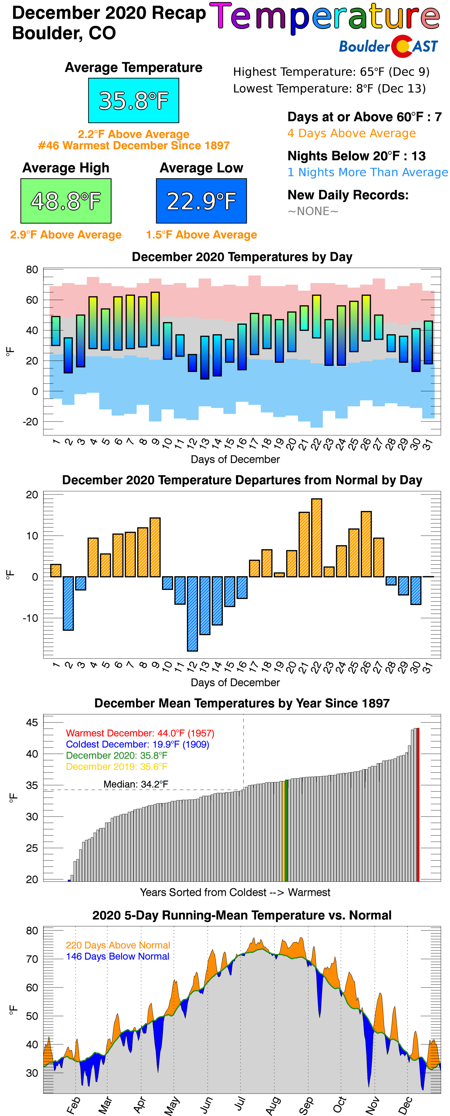
December 2020 was marred by a series of weak storm systems that resulted in very little snowfall. This lack of moisture further exacerbated the ongoing drought in Colorado and dashed the hopes of many for a white Christmas in our area. Overall, it was yet another warm and fairly dry month. In fact, this was the sixth month in a row that ended warmer and drier than normal. Here’s a quick and colorful rundown of our weather during December and how it relates to climatology.
Help support our team of Front Range weather bloggers by joining BoulderCAST Premium. We talk Boulder and Denver weather every single day. Sign up now to get access to our daily forecast discussions each morning, complete six-day skiing and hiking forecasts powered by machine learning, first-class access to all our Colorado-centric high-resolution weather graphics, bonus storm updates and much more! Or not, we just appreciate your readership!

Top Weather Highlights of December 2020:
REX BLOCK PATTERN KICKED OFF THE MONTH: A stagnant pattern known as a “rex block” developed late in November and persisted into early December across the western United States. During this time period (Nov 26-Dec 10), no measurable precipitation occurred across the Denver Metro area exacerbating existing severe drought conditions.
Today will be our 6th consecutive day with sunny skies. This tranquil stretch is the result of a stagnant atmospheric pattern known as a rex block which developed late last week over the western US. Highs Tue & Wed will soar into the 60's in Denver#COwx #RexBlock pic.twitter.com/aBey25z655
— BoulderCAST Weather (@BoulderCAST) December 8, 2020
A TALE OF TINY SNOWSTORMS: The weather gods were not in our favor in December with most if not all storms arriving to the Front Range half-baked. Either the track was unfavorable, the storm was too weak, or the large-scale system was moving too fast. In all cases, though, the amount of snow produced was meager leading to underwhelming snow totals for the month as a whole. Boulder recorded 9 days with snowfall which is above normal. However, those 9 days only amounted to 5.8″ of snow which is less than half of normal. Similarly, Denver reported 10 days with snow falling but only 7.0″ of total accumulation.
Shockingly, @DENAirport led the way in three-day snow totals across the Boulder/Denver area (including the Foothills)! Here's why: https://t.co/1IsTooywBZ#COwx #Snow #Boulderwx pic.twitter.com/NFk4C4FUeM
— BoulderCAST Weather (@BoulderCAST) December 13, 2020
Visit our 2020-2021 Winter Snow Summary
EAST COAST NOR’EASTER: The biggest snowstorm in 10 to 20 years dumped more than 3 FEET of wet snow in several East Coast states from December 16th to 18th.
The biggest snowstorm in YEARS is unfolding along the East Coast today and tonight. A large swath from Pennsylvania to western Massachusetts could see more than 18" of snow. This type of strong coastal low pressure system is called a nor'easter.#PAwx #NYwx #Noreaster #COwx pic.twitter.com/bR6L5Qcyi6
— BoulderCAST Weather (@BoulderCAST) December 16, 2020
Some of the craziest snow totals came out of the Binghamton, NY area at more than 44 inches!
44 inches of snow fell in Binghamton, NY. Wow. ❄️❄️❄️
— #TodayInSports (@TodayInSports3) December 18, 2020
THUNDERSNOW (!) AND STRONG WINDS: On December 22nd a strong Pacific cold front blew from west to east across the entire state of Colorado. Very cold air aloft fueled convective snow showers across the Mountains prompting a handful of Snow Squall Warnings to be issued. The most intense wintry cell near Steamboat Springs produced more than a dozen lightning strikes and a visibly horrifying snow squall line.
At ~5:00PM this evening, a small convective snow shower moved directly over Steamboat Springs producing heavy snow and more than a dozen lightning strikes. THUNDERSNOW!#COwx #Thundersnow @SteamboatCO @skisteamboat pic.twitter.com/Z22UYowRjE
— BoulderCAST Weather (@BoulderCAST) December 23, 2020
Squall at once.
Samantha Tisdall caught this
wild snow squall rolling over Emerald Mountain in Steamboat Springs. #9News #9wx pic.twitter.com/iJuWuGyUdA— Matt Renoux (@MattRenoux) December 23, 2020
Across the lower elevations, the convective snow showers largely dissipated but the winds remained with gusts accompanying the frontal passage blowing in excess of 70 MPH. The highest gust on the Plains was 92 MPH in west Arvada at the normally very gusty intersection of Highway 72 and Highway 93.
Several wind gusts of 70-110 MPH reported last evening as the cold front blew thru accompanied by convective snow showers.
-109 MPH Kenosha Pass
-92 MPH at Hwy 93 & Hwy 72 in west Arvada
-90 MPH Vail Pass
-73 MPH NW Boulder on Olde Stage Rd
-61 MPH at KBDU#COwx #HighWinds pic.twitter.com/3lEnbEojl6— BoulderCAST Weather (@BoulderCAST) December 23, 2020
A BROWN CHRISTMAS: Despite Boulder’s climatology painting Christmas Day as the most likely to have snow on the ground, 2020 failed to deliver notching the warmest Christmas temperature in 15 years. Skies were completely sunny and the ground was largely snow-free.
A disappointingly sunny Christmas Eve & Day, but cooler and more unsettled weather arrives Sunday into next week#COWX #BrownChristmas #NoSnow #Boulderwx pic.twitter.com/G9uibiTOWP
— BoulderCAST Weather (@BoulderCAST) December 24, 2020
December 2020 Recap Graphics:
.
Spread the word, share Colorado’s crazy weather:
We discuss Boulder and Denver weather every single day on BoulderCAST Premium. Sign up today to get access to our daily forecast discussions every morning, complete six-day skiing and hiking forecasts powered by machine learning, access to all our Front Range specific weather models, additional storm updates and much more!


You must be logged in to post a comment.