The return of winter this past weekend has been well-received by most! Quiet weather starts the week under high pressure with temperatures on the rise and the fresh snow melting. However, expect a gradual trend toward chillier temperatures later in the week. The extended outlook shows signs of an active pattern with snow chances over the weekend and into next week. Let’s take a look!
This week’s highlights include:
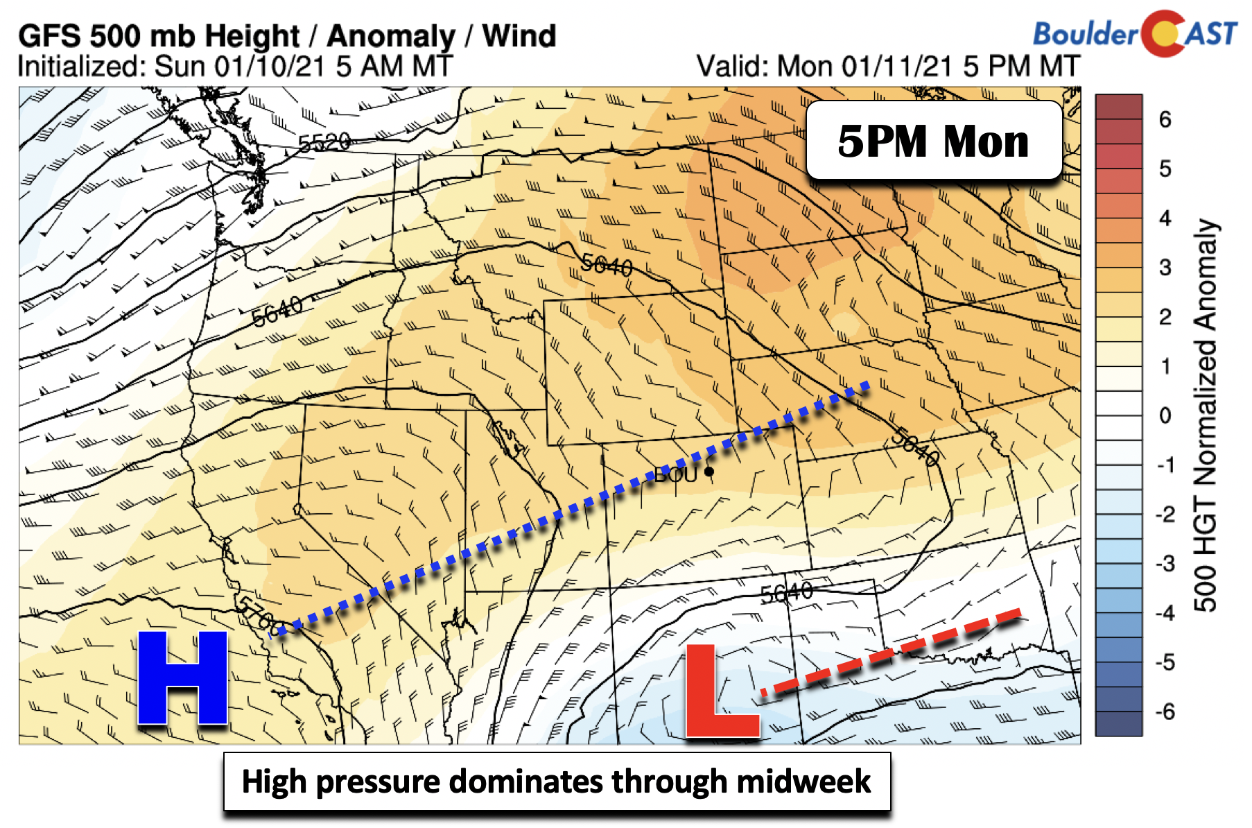
- High pressure dominates through midweek with sunshine and moderating temperatures
- Snow cover keeps temperatures in check initially, but Wednesday could be comfortably warm
- Late-week cold front brings cooler temperatures and snow chances to mountains
- Colder and more active for the weekend ahead with snow?
DISCLAIMER: This weekly outlook forecast is created Monday morning and covers the entire upcoming week. Accuracy will decrease as the week progresses as this post is NOT updated. To receive daily updated forecasts from our team, subscribe to BoulderCAST Premium.

Winter returned over the weekend
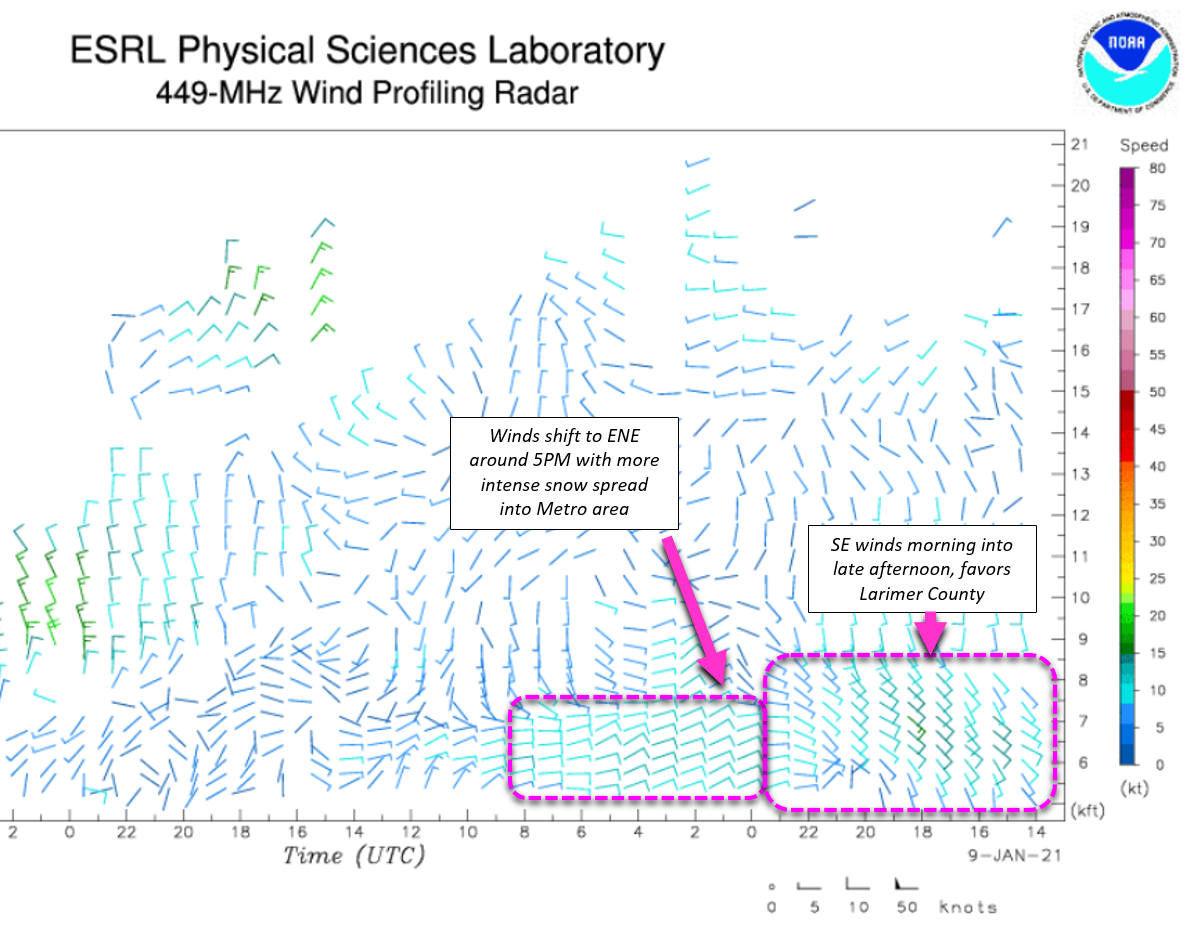
It took a little bit longer than expected for snow to get going in most of the Denver Metro area this past Saturday. We started the day with just a few flurries, with cold overcast conditions persisting through the entire day, but not much actual snow. Finally, by early evening winds turned easterly and brought widespread upslope precipitation to the area. Up until this shift, winds were coming from the southeast most of the day which is downslope for the immediate Denver Metro area off the Palmer Divide. With a lack of any other real forcings, this prevented any snow in our area for the time being. The key shift in wind direction can be seen in the data recorded by NOAA’s wind profiling radar, occurring roughly around 23 UTC (4PM Mountain Time) Saturday evening.
Once the winds shifted, precipitation sagged southward from the Fort Collins area and into the Boulder/Denver area Saturday evening. As you can see in the radar animation below, there were even a few moderate snowfall bands embedded in the larger shield of precipitation. The bands remained somewhat stationary for several hours leading to accumulations of 4 to 5″ in “lucky” spots. There was no jet-forcing for this event, so these bands were purely caused by upslope and/or convergence.
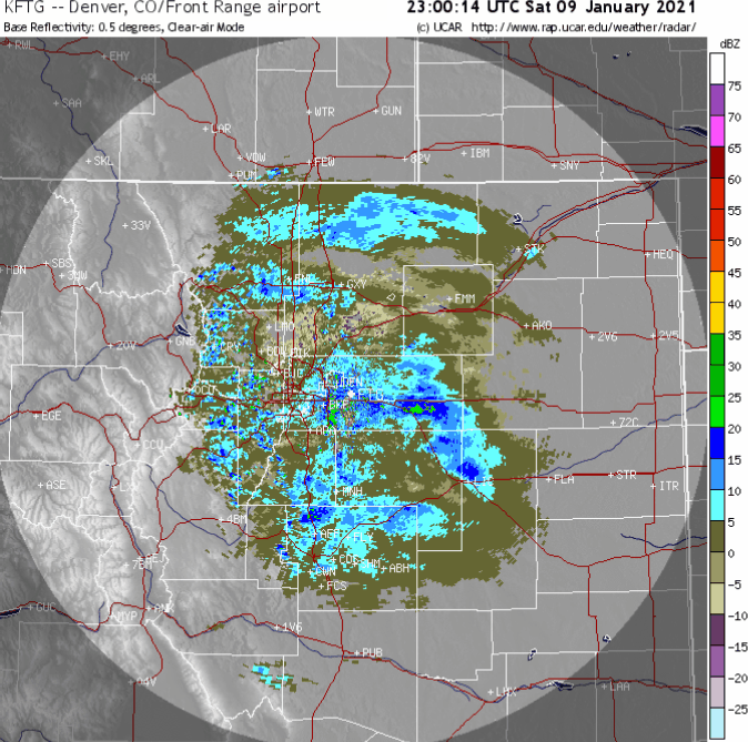
Radar animation from Saturday afternoon and evening, January 9 2021, with widespread snow falling in the area
The Boulder area picked up several hours of moderate snowfall leading to slightly higher totals, while in Denver proper it didn’t snow quite as long or hard with totals more modest. Shown below is our snowfall forecast map issued Saturday morning with actual storm totals overlaid in boxes. Green boxes indicate that our forecast verified to within one inch of the observed snowfall. Red did not.
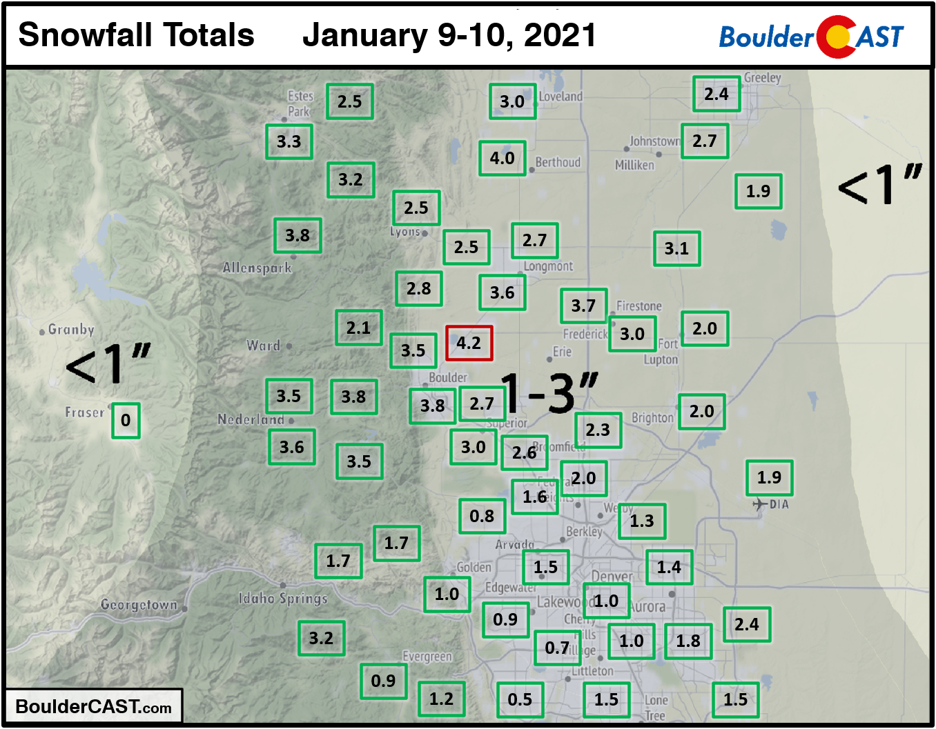
Officially Boulder reported 3.8″ of new snow. There was 1.9″ recorded with this system at DIA, the official observation site of Denver (which in a rare instance, this time did better than downtown Denver). As expected, southern Colorado saw more widespread 2 to 4″ totals compared to our neck of the woods. That’s just the nature of the business with a storm center tracking so far south and west. It’s also worth noting that this particular snow event impacted only areas east of the Continental Divide. The Mountains saw next to no snow since this storm was driven entirely by weak upslope that wasn’t deep enough to get over the first front of peaks.
Visit our 2020-2021 Winter Snow Summary
A quiet start
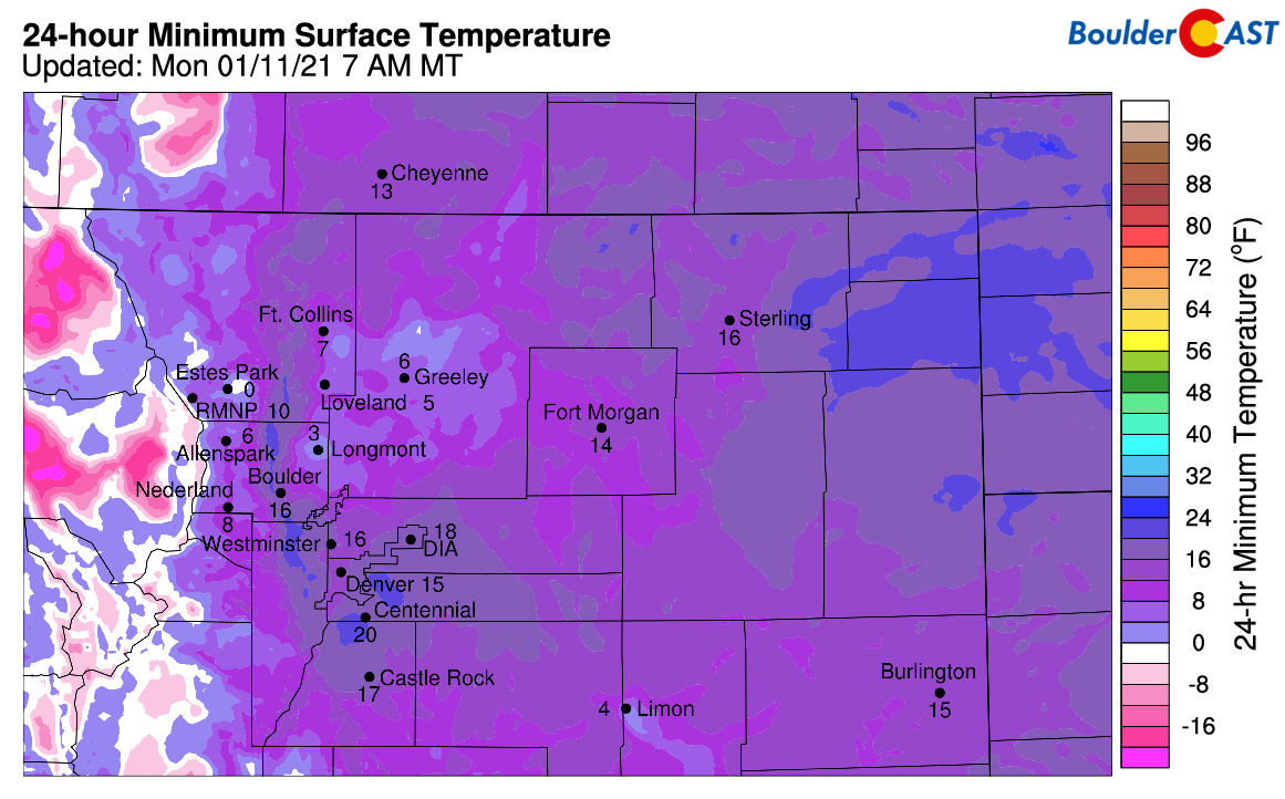
Following the fresh snow this weekend and clear skies overnight, temperatures are very chilly across the region on this Monday morning. We’re talking single digits and lower teens for the Plains, and well below zero in the Mountains. Bundle up if heading out early today!
Quiet weather will start out our week. A ridge of high pressure extends from just southwest of California into Colorado and Nebraska. Rising mid-level heights today will continue to spell out lots of sunshine. With still a good amount of snow cover on the ground, temperatures will only reach the lower 40’s this afternoon under light winds. Areas that received the most snow may actually stay in the 30’s today.
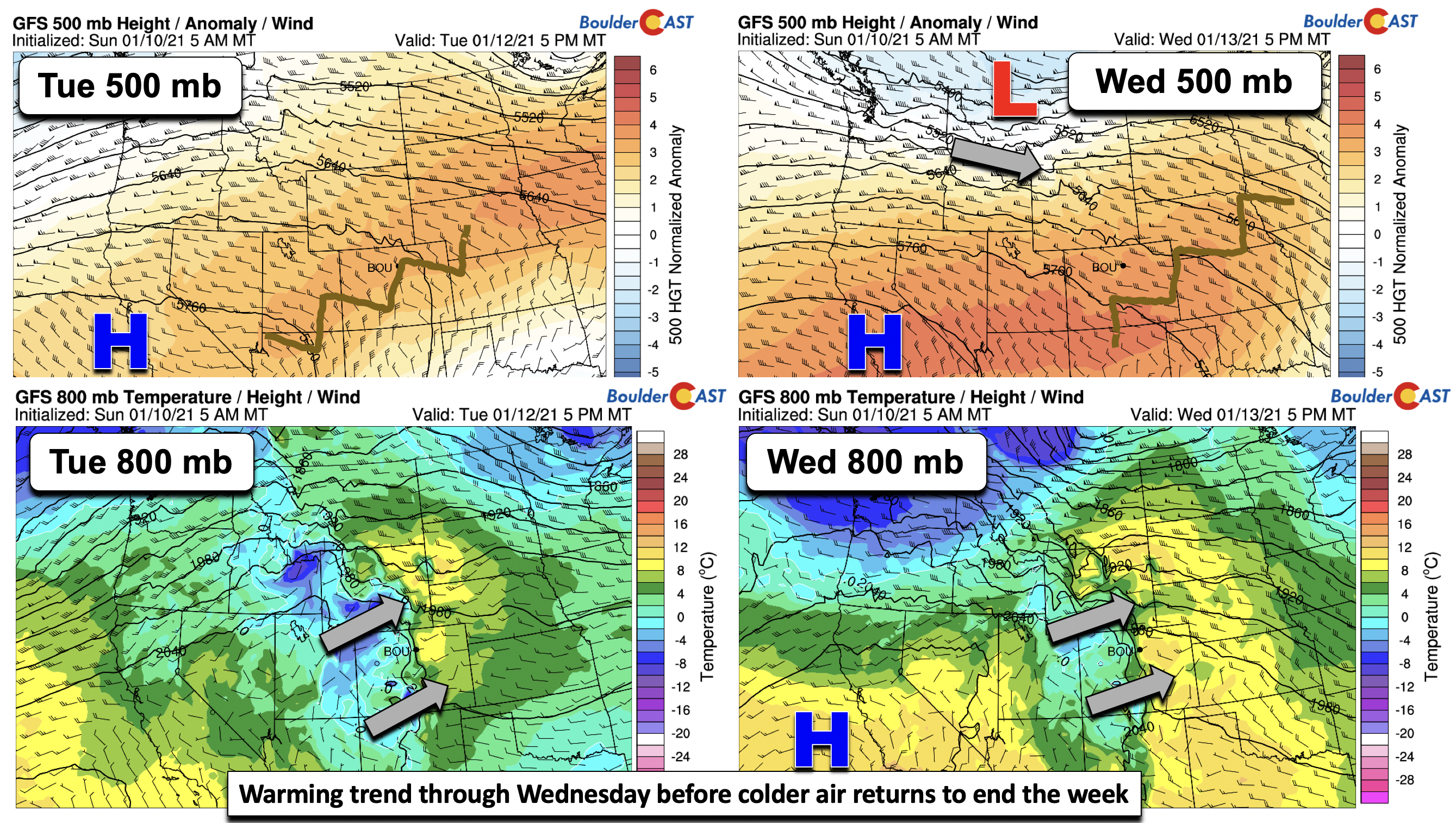
Warmth spreads east Tuesday into Wednesday
The ridge of high pressure situated off the west coast will continue to dominate our weather pattern through Wednesday (below top panel figures). Mid-level heights will further rise the next few days. Coupled with this will be warming in the lower atmosphere (bottom figures below)….mainly downslope warming. Most of the snow cover will likely be gone by late Tuesday, so Wednesday will be our warmest day with temperatures close to 50 degrees Tuesday and middle to upper 50’s Wednesday. Won’t that feel nice?
Transition to colder weather Thursday…snow?
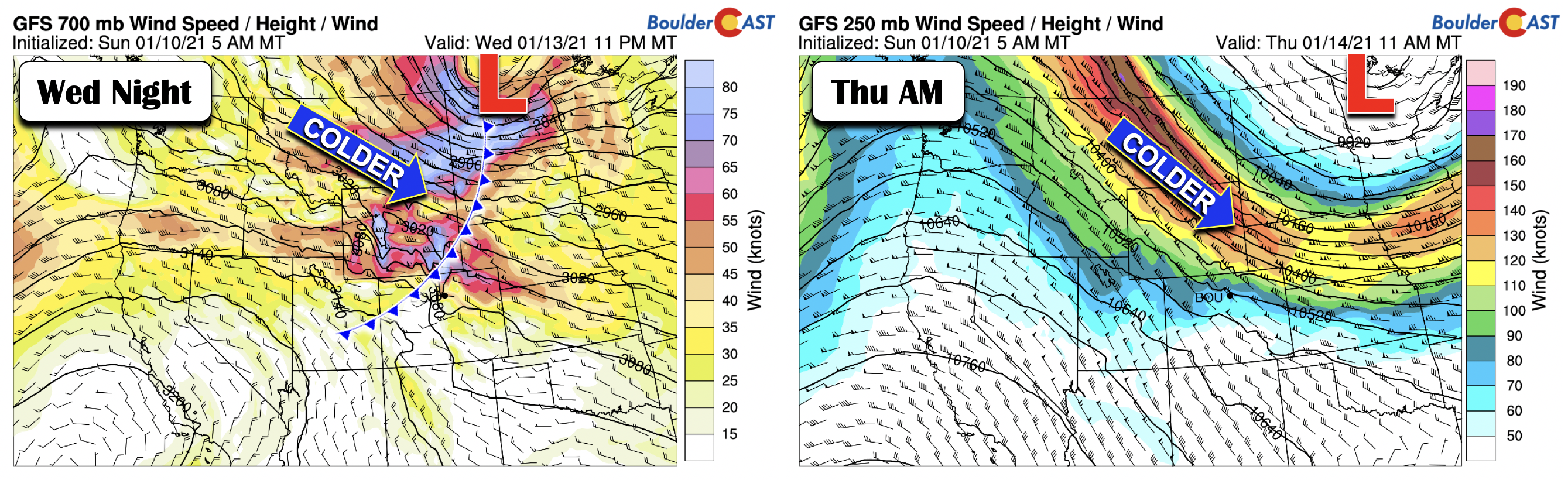
Late Wednesday night, the forecast guidance are in good agreement of a strong cold front slated to track through northeast Colorado as a trough of low pressure sags southward out of Canada into the Midwest (below). Gusty winds will likely accompany the front Wednesday night/early Thursday tied to the upper-level jet stream.
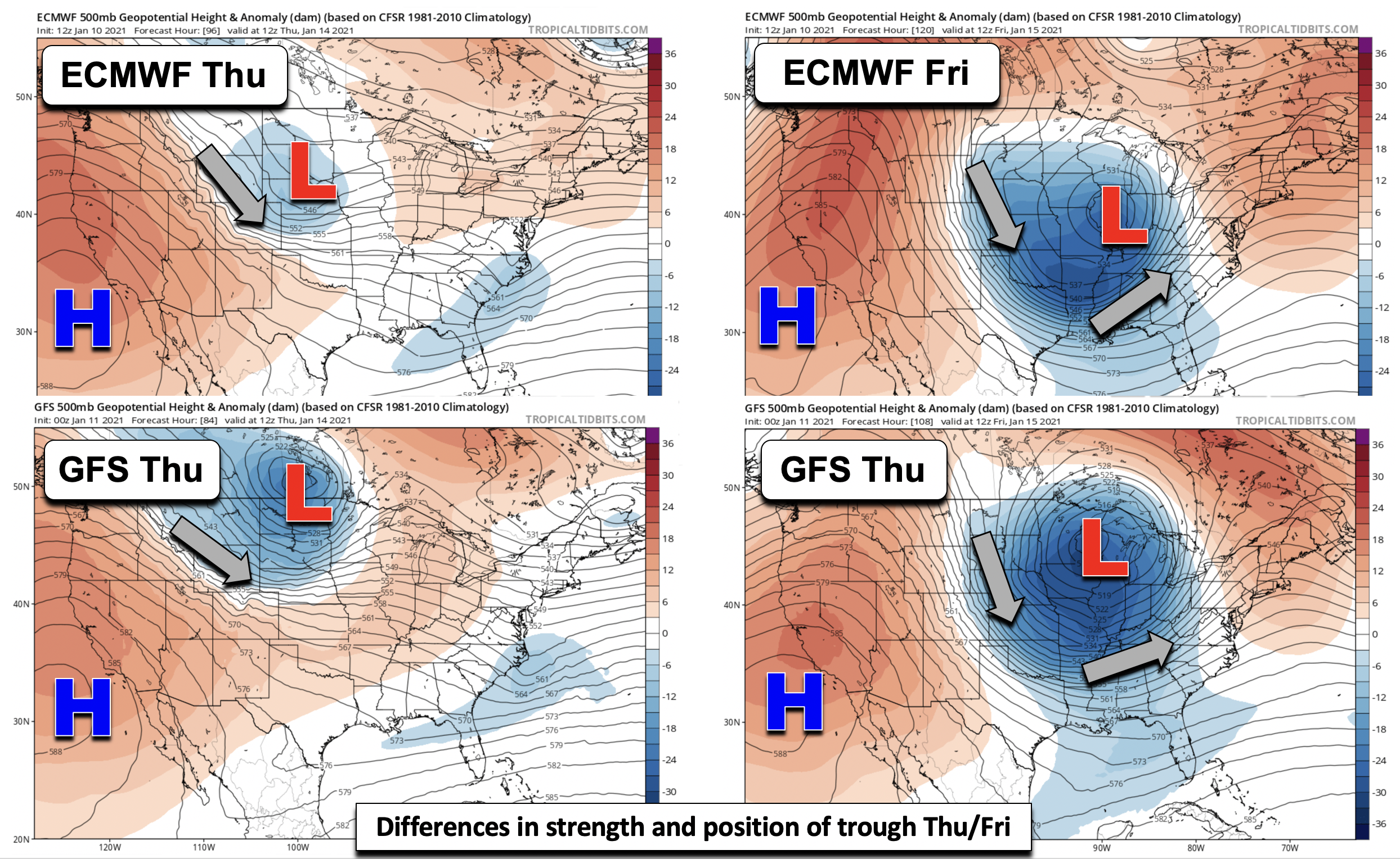
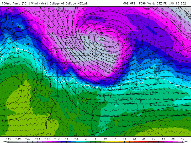
There are differences in the position and strength of the trough late in the week, and, as a result, its corresponding effect on our sensible weather. The Euro model (top panels below) shows the low pressure center on Thursday over Nebraska, moving into Illinois by Friday. The GFS (bottom panels below), however, shows the low pressure center over North Dakota Thursday, tracking into Minnesota by Friday. These are not trivial differences! Thus, there is some uncertainty in the late-week outlook. With all that said, expect a colder trend and gusty winds late Wednesday/Thursday with temperatures likely falling to the upper 30’s for highs on Thursday. The Euro’s low pressure location would favor some light snow for NE Colorado, while the GFS’s track is certainly less favorable. Right now, we are keeping the forecast mostly dry, but this will need to be monitored as things progress through the week. On Friday, temperatures will moderate, but given the uncertainty, we are only bumping up temperatures into the middle 40’s.
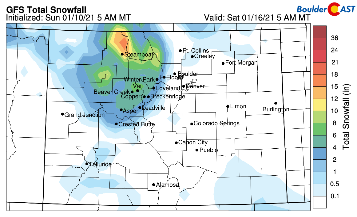
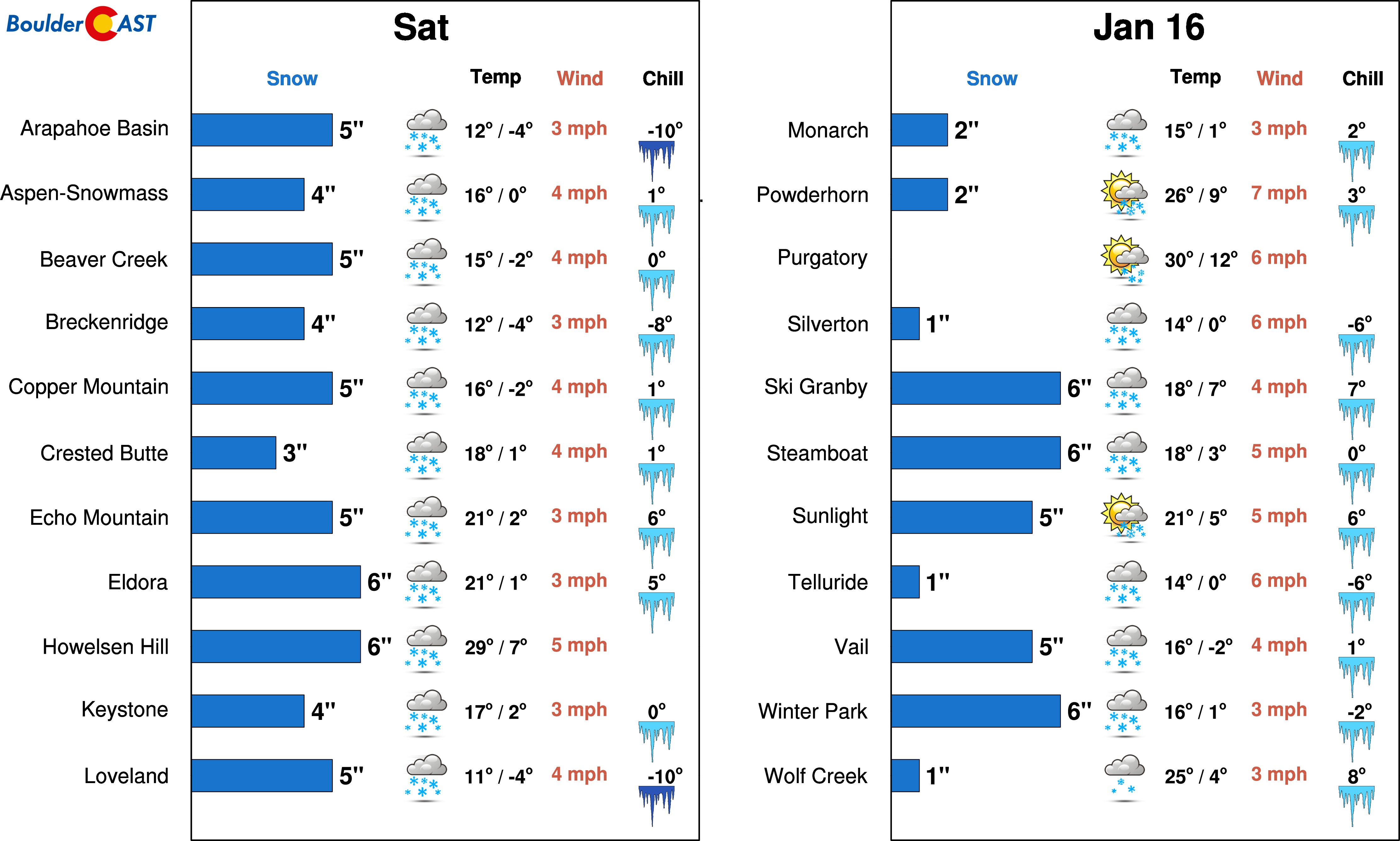
The better chance of Thursday snow will be over the higher terrain, especially in the favored areas under northwest flow, such as Steamboat, Vail, Winter Park, and Copper Mountain (below). A fresh dumping of powder is likely in these areas, so you may want to consider hitting the slopes late in the week.
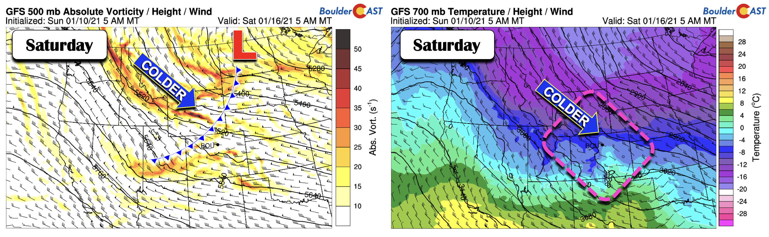
Better chance of snow for upcoming weekend
A better chance of snow is looking possible for the upcoming weekend. There is decent agreement in both the deterministic guidance and ensembles for a more favorable storm track, typical of La Niña. As the late-week cold front moves through with a trough, the amplified pattern should allow for a developing northwest flow to persist for the upcoming weekend, allowing the jet stream to extend further west as early as Saturday (below). Along with cold air and lift, a period of snowfall looks plausible Saturday into Sunday in the Denver Metro area.
As mentioned above, the ensembles (below) show some agreement with the weekend snow potential, with several members indicating measurable snowfall on Saturday. As you can also see below, the pattern looks active with numerous shots of light snow into early next week.
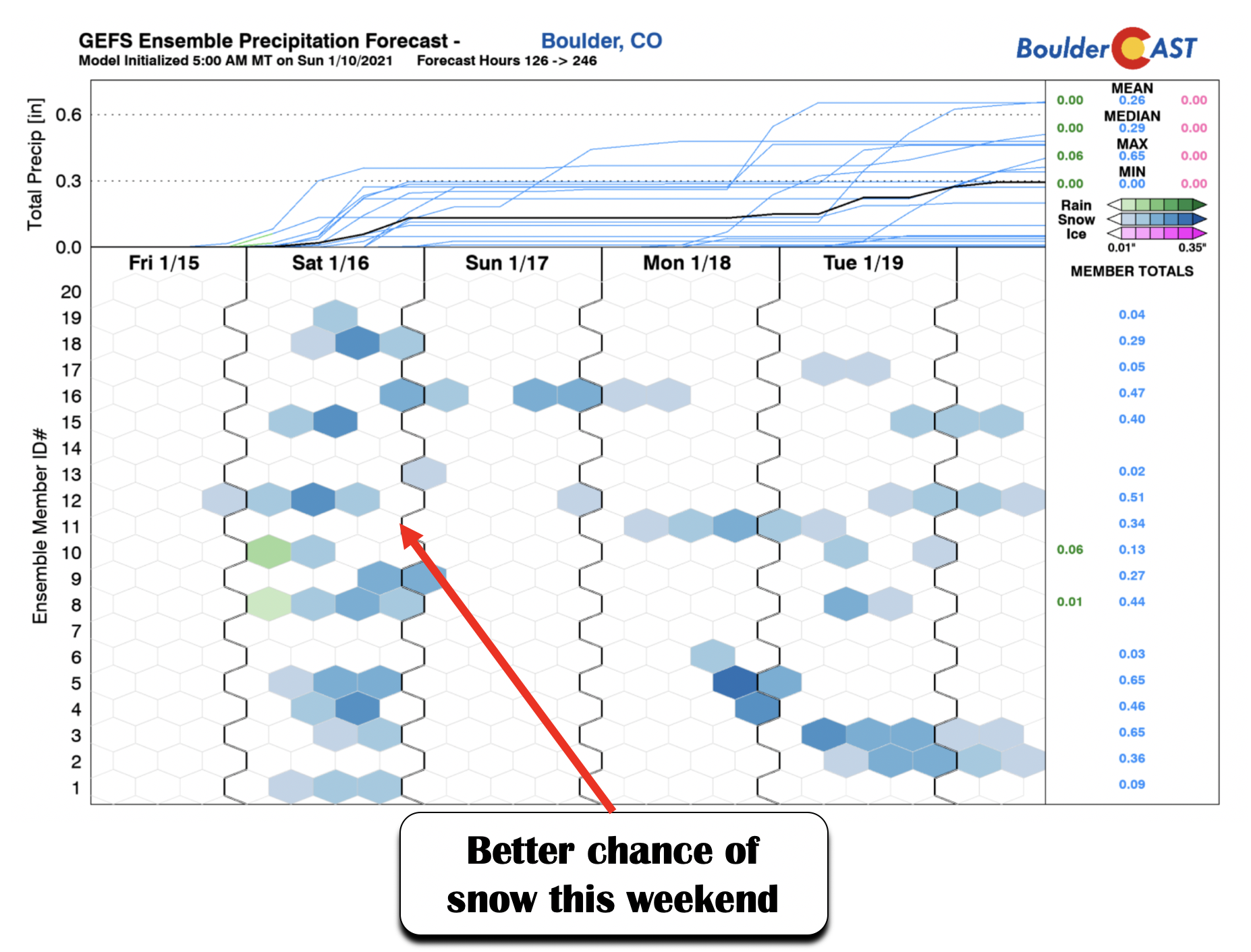
While this next animation is borderline gazing into fantasy land, the ensemble figure above tells us that a more active pattern is probable as we go into next week and beyond. It appears that the ridge of high pressure breaks down, allowing for several troughs of low pressure to dip into Colorado, giving us a favorable La Niña pattern with light snow events. It also looks much colder, with some of the coldest air of the season possibly arriving late next week. It’s certainly something for you cold and snow-lovers to watch out for, but for now, is too far into fantasy land for our comfort.
Forecast Specifics:
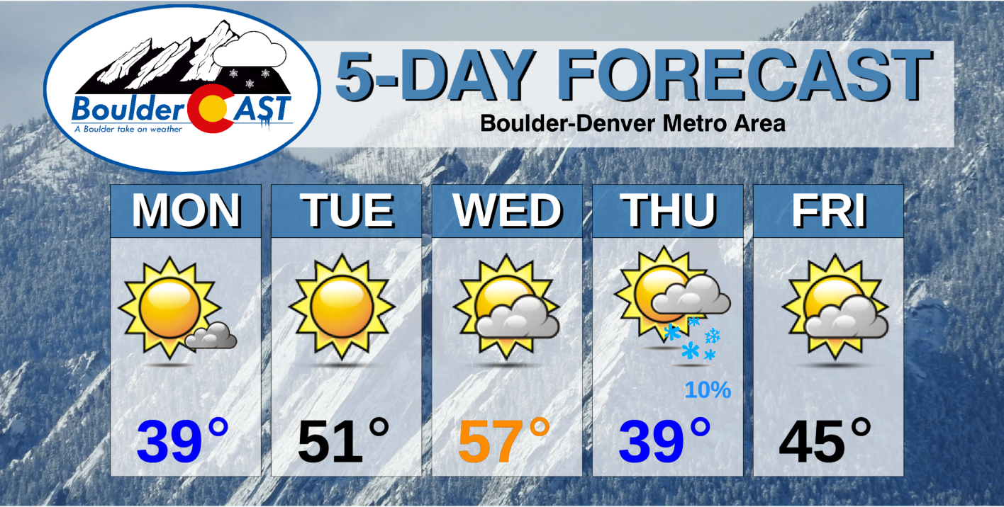
Monday: Mostly sunny and cool. Temperatures in the lower 40’s on the Plains and lower 30’s in the Foothills.
Tuesday: Sunny and pleasant. Highs near 50 on the Plains and upper 30’s in the Foothills.
Wednesday: Increasing clouds. Temperatures in the middle 50’s on the Plains and lower 40’s in the Foothills.
Thursday: Partly sunny with a slight chance of snow in the morning, becoming sunny in the afternoon. Highs in the upper 30’s on the Plains and lower 30’s in the Foothills.
Friday: A mix of clouds and sunshine with temperatures in the middle 40’s on the Plains and middle 30’s in the Foothills.
Weekend: Accumulating snow is possible Saturday into Sunday, along with colder temperatures into early next week.
Mountains: Quiet weather dominates the mountains through midweek. Gusty winds and snowfall are likely late Wednesday and early Thursday. Gusty winds but clearing is expected on Friday, before another chance of snow returns on the weekend.
Help support our team of Front Range weather bloggers by joining BoulderCAST Premium. We talk Boulder and Denver weather every single day. Sign up now to get access to our daily forecast discussions each morning, complete six-day skiing and hiking forecasts powered by machine learning, first-class access to all our Colorado-centric high-resolution weather graphics, bonus storm updates and much more! Or not, we just appreciate your readership!
.
Spread the word, share the BoulderCAST forecast!
.


You must be logged in to post a comment.