
The first week of 2021 will not make much of a mark for the Front Range. We’re watching a series of quick-moving but ultimately weak storm systems that will scurry across the Rockies throughout the upcoming week. Mountain snow will be the main story, but we’ve also got a bora wind event in the works for the Plains and possibly some late-week snow as well. Read on for all the details.
This week’s highlights include:
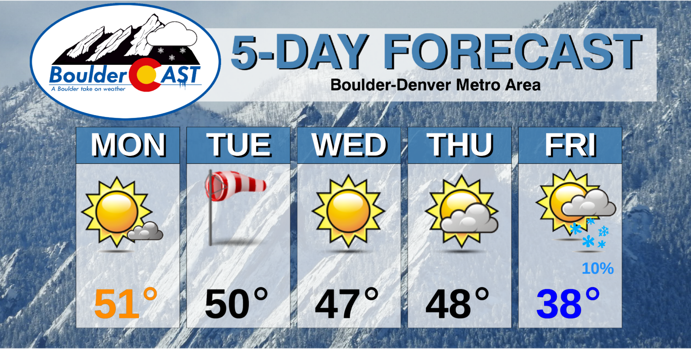
- A ridge on Monday brings quiet weather with highs in the low 50’s
- A bora-type Pacific frontal boundary blows through Tuesday with gusty winds, worst north and east of Denver
- By mid-week, another ridge passes through with sunshine and seasonal temperatures
- The active northwest flow pattern roars onwards Friday into the weekend with several, albeit minor chances at light snow
- Mountain snow expected both on Tuesday and Friday into Saturday with light accumulations only
DISCLAIMER: This weekly outlook forecast is created Monday morning and covers the entire upcoming week. Accuracy will decrease as the week progresses as this post is NOT updated. To receive daily updated forecasts from our team, subscribe to BoulderCAST Premium.

A tame Monday
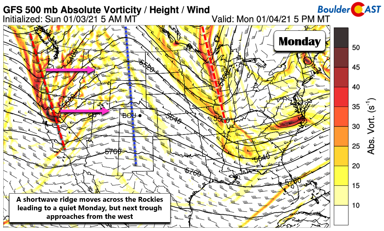
Monday will continue the trend established over the last handful of days with more tame weather across the Front Range. The large-scale atmospheric setup for Monday has a shortwave ridge axis stretching up and down the spine of the Rockies, from New Mexico into Alberta. This ridge axis, while short-lived in our area, will lead to sunny skies and mild temperatures for Monday in the lower 50’s around Denver. However, just to the west, yet another fast-moving Pacific trough is encroaching. It will arrive to northern Colorado early Tuesday so get ready!
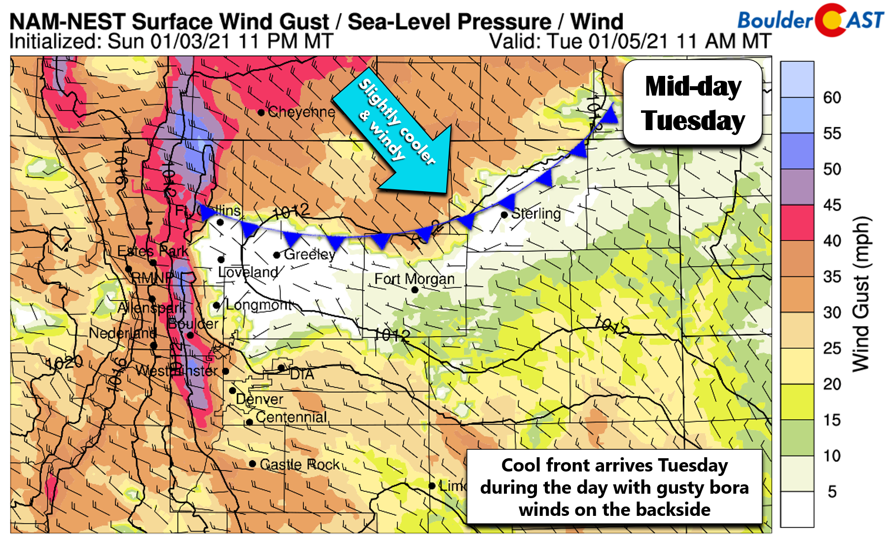
A gusty Tuesday
The aforementioned trough is ticketed to blow across the area quickly on Tuesday bringing together strong winds aloft and subsident motion in the atmosphere. This will produce a period of gusty bora winds across the Front Range Tuesday during the late morning and afternoon hours. The best ingredients for high winds will be across southeast Wyoming and then push into the eastern Plains of Colorado. It won’t be as bad for us, but still we are expecting gusts of 30 to 40 MPH in the Denver Metro area during the day Tuesday. Temperatures again will be mild near 50 degrees, but will fall slightly through the day as the cooler Pacific air surges in from the northwest.
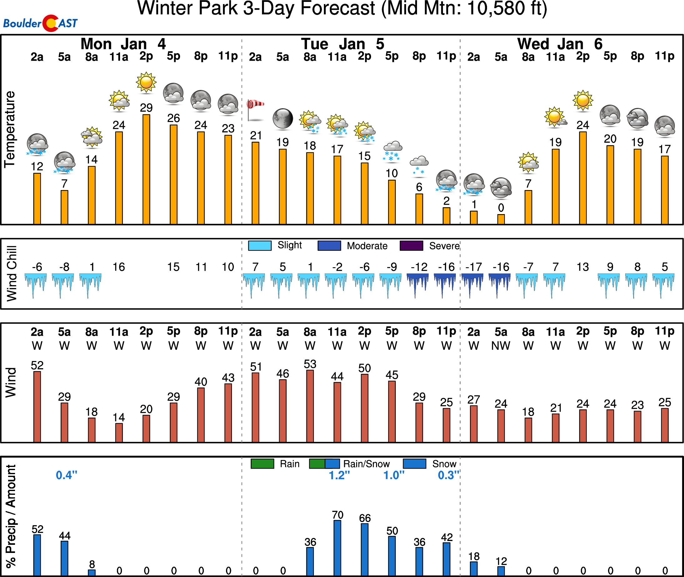
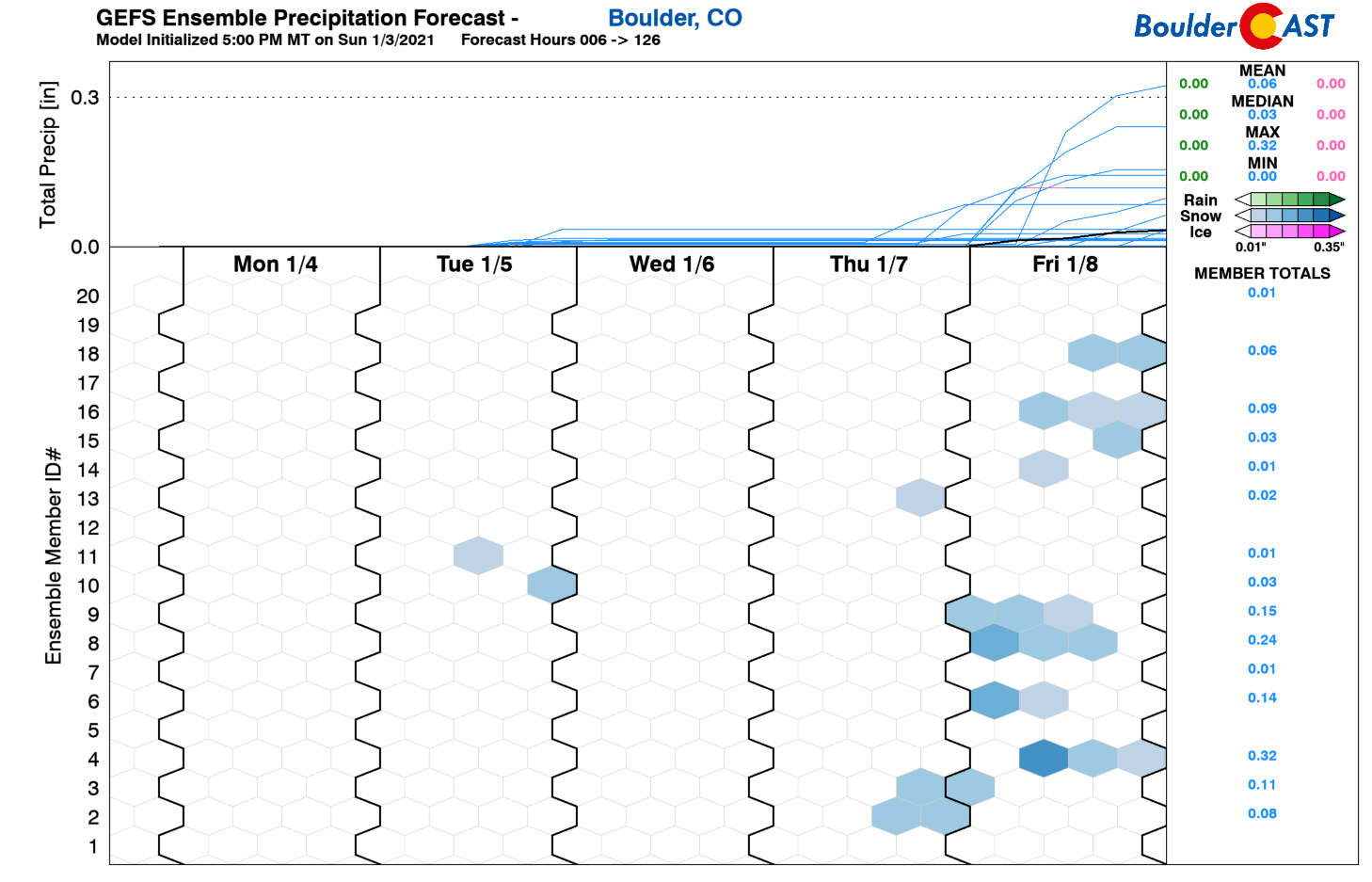
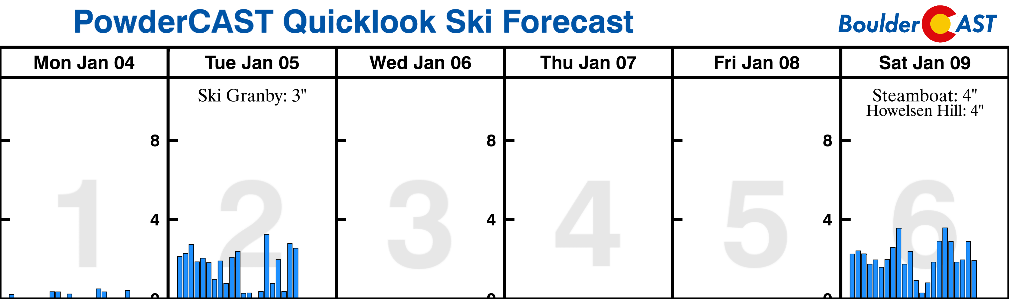
Orographic snow will accompany this trough in the Mountains, but it too will be short-lived producing just 1-4″ of new accumulation early Tuesday morning into Tuesday evening. Not much if any precipitation is expected east of the Continental Divide with downslope reigning king for this system. There could be a few sprinkles or flurries Tuesday afternoon, but chances are this will be along the Wyoming border and east of Interstate 25.
High pressure Wednesday & Thursday
In the wake of Tuesday’s trough, the mid-week period will be quiet for most of Colorado as another shortwave ridge moves through. After cool northwest flow on Wednesday, the ridge axis will actually pass Wednesday night with flow thereafter turning southwesterly. This will facilitate slight warming, but temperatures will still be just a tad above normal. Both days will be dry with lots of sun Wednesday and more cloud cover Thursday.

Late-week snow?
By the end of this rather boring week, we’ll have a chance for light snow as another shortwave system sweeps across the area from the northwest (well, two systems actually). There’s nothing to get excited for yet as models are still quite varied on potential solutions. Regardless, both will be quick-movers with limited moisture so at best we’d likely be looking at a few tiny rounds of snow (0 to 3″). The Mountains stand a better chance, as usual, to see appreciable accumulating snow late in the week heading into the weekend. For now, we’ll keep the chance of snow Friday only at 10% for the Boulder/Denver area with highs dipping back into the 30’s behind a cold front. There will be another chance of snow on Saturday as well, though details are murky at best right now. The upcoming weekend will be colder and less pleasant than this past weekend…that’s for sure!
We wish you all a great first week to this New Year!
Forecast Specifics:
Monday: Mostly sunny, mild and quiet. Temperatures in the lower 50’s across the Plains and upper 30’s in the Foothills.
Tuesday: Partly cloudy and windy with gusts up to 35 MPH in the afternoon and evening. Highs near 50 on the Plains and in the upper 30’s in the Foothills. There could be a few sprinkles or flurries east of Interstate 25 from late afternoon into evening.
Wednesday: Sunny and seasonal with highs in the middle 40’s on the Plains and lower 30’s in the Foothills.
Thursday: Some morning sunshine, then increasing clouds. Highs in the upper 40’s on the Plains and middle 30’s in the Foothills.
Friday: Colder with a slight chance of snow showers. Little to no accumulation expected. Highs in the upper 30’s on the Plains and upper 20’s in the Foothills.
Weekend: Unsettled but ultimately uncertain conditions will remain through the upcoming weekend. Temperatures should remain cold in the 30’s for the area with a chance for more light snow Saturday. Accumulation potential is TBD.
Mountains: After a mostly quiet Monday with relaxing winds, snow and strong winds will spread in the Mountains late Monday night and continue into Tuesday evening. 1-4″ of accumulation is expected. Travel could be hazardous at times Tuesday into Tuesday night mainly due to blowing snow. A lull in the action is expected Wednesday through Friday morning with lighter winds and partly to mostly sunny conditions. Snow returns to the High Country late Friday into Saturday with another round of accumulations possible for most ski resorts.
Help support our team of Front Range weather bloggers by joining BoulderCAST Premium. We talk Boulder and Denver weather every single day. Sign up now to get access to our daily forecast discussions each morning, complete six-day skiing and hiking forecasts powered by machine learning, first-class access to all our Colorado-centric high-resolution weather graphics, bonus storm updates and much more! Or not, we just appreciate your readership!
.
Spread the word, share the BoulderCAST forecast!
.


You must be logged in to post a comment.