The pesky trough that produced cold and gloomy weather all week long for us will finally push across Colorado Thursday night into Friday. This passage will produce widespread showers from late afternoon Thursday into the overnight. It will begin as rain, but quickly change to snow with several inches of accumulation likely for the Denver Metro area. Let’s take a closer look at this storm and where the most snow will fall. Continue reading
Category: Forecast (Page 80 of 169)

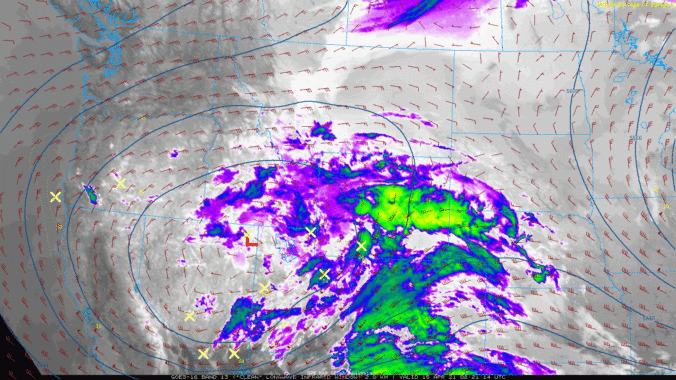
The light and patchy snow that fell Tuesday morning was just a taste of what’s to come the rest of the week with daily chances for winter weather lasting all the way into the weekend. Of immediate concern is our next chance of snow Tuesday evening into Wednesday morning which will be more fruitful in most locations. We discuss the timing and amounts of this next wave of snow and also look ahead to what may come later on in the week.
Continue reading

This week will be gloomy and unsettled with several chances of snow through Friday, though some rain will mix in at times. Temperatures are forecast to remain below seasonal normals under persistent upslope flow and overcast skies. Overall, it should be an active weather week for much of Colorado. Let’s take a look.

April has been an incredibly warm month so far in the Front Range, but that will change next week as a major pattern shift takes hold. Gloomy and unsettled conditions will spread in Tuesday and beyond with daily chances for rain and snow. Due to marginal temperatures, the highest probably of significant snow accumulations will be in the Foothills, but just about everywhere will see snow at times. Let’s take a quick look at the still evolving forecast for next week.

The week begins right where the weekend left off with record warm temperatures on-tap for Monday. However, change will come quickly Tuesday with much colder temperatures, rain changing to snow, and even a little thunder thrown into the mix. The back-half of the week will be quiet, mild and sunny with this trend flowing right into the upcoming weekend. Read on for our complete outlook of the week ahead.

Our weather will be incredible over the next few days with the warmest stretch thus far in 2021 persisting across the Front Range. After the multi-day threat of record high temperatures, we will see a cooldown next week.
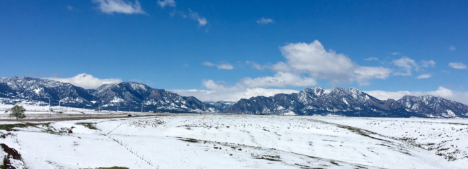
From 70’s to falling snow in only eight hours! That’s the weather that unfolded Monday afternoon into the overnight hours across the Front Range, with most of us waking up to a layer of wet snow Tuesday morning. Let’s take a look how we got here, review the storm totals, and take a peek ahead to the beautiful weather in the extended forecast.

The last few days of March will bring a series of temperature swings from above to below average and back again, along with a chance of snow. However, as we enter into April, spring-like conditions will firmly take charge with dry weather and temperatures in the 70’s likely for an extended period lasting through the upcoming weekend.

Live View of Boulder

Current Conditions

Live Radar

Latest Smoke Forecast

Recent Premium Posts

BoulderCAST Daily – Wed 07/15/26 | The Ridge Rules the Rockies as Hot, Dry Pattern Holds Firm
🔥 Heat dome setup continues — A strong, stationary 500 mb ridge keeps …
BoulderCAST Daily – Tue 07/14/26 | The Front Range Continues to Bake Under Expansive Ridge
🔥 Heat streak continues — Boulder hit 97°F for the third time in …
BoulderCAST Daily – Sun 07/12/26 | Hot weather for a good chunk of the coming week
🥵 🔥 Heat for a good chunk of the week: Upper 90s through …
3-Day Forecast

Trending Content

© 2026 Front Range Weather, LLC