
This week will be gloomy and unsettled with several chances of snow through Friday, though some rain will mix in at times. Temperatures are forecast to remain below seasonal normals under persistent upslope flow and overcast skies. Overall, it should be an active weather week for much of Colorado. Let’s take a look.
This week’s highlights include:
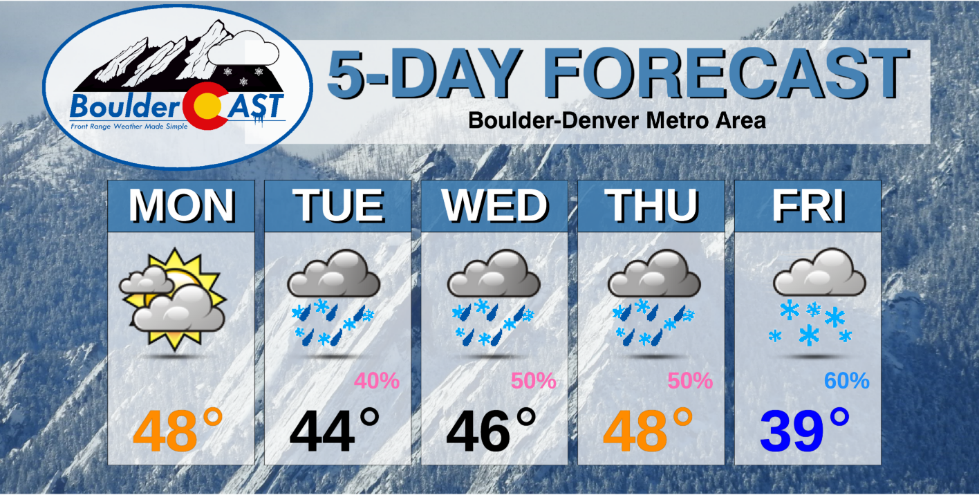
- Temperatures will remain well below average through the week, mostly in the 40’s
- Chances of rain and snow throughout the entire week, although certain periods are favored more than others
- The best chance for heavier accumulating snow comes late in the week
- Lots of uncertainty overall this week, especially in regards to the broader storm system’s track, timing of the best precipitation chances, and the resulting snow amounts
DISCLAIMER: This weekly outlook forecast is created Monday morning and covers the entire upcoming week. Accuracy will decrease as the week progresses as this post is NOT updated. To receive daily updated forecasts from our team, subscribe to BoulderCAST Premium.

A very active and snowy pattern
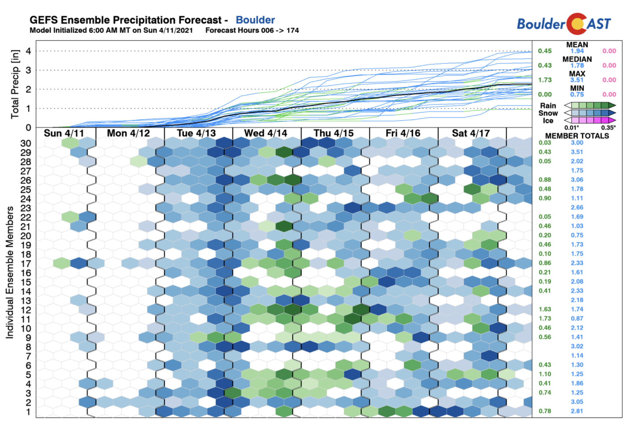
An active and snowy pattern is taking shape this week. To give you a sense of what we might be in store for, below shows the GEFS model precipitation forecast for Boulder through Saturday. You’ll notice rain and snow every single day coming from every model run. Thus there is good agreement that it’s going to be rather unsettled week overall. The question will be how much snow actually accumulates by the end of the week and when the best chances for precipitation will be. It certainly won’t be raining or snowing the entire time, so let’s break it down for you.
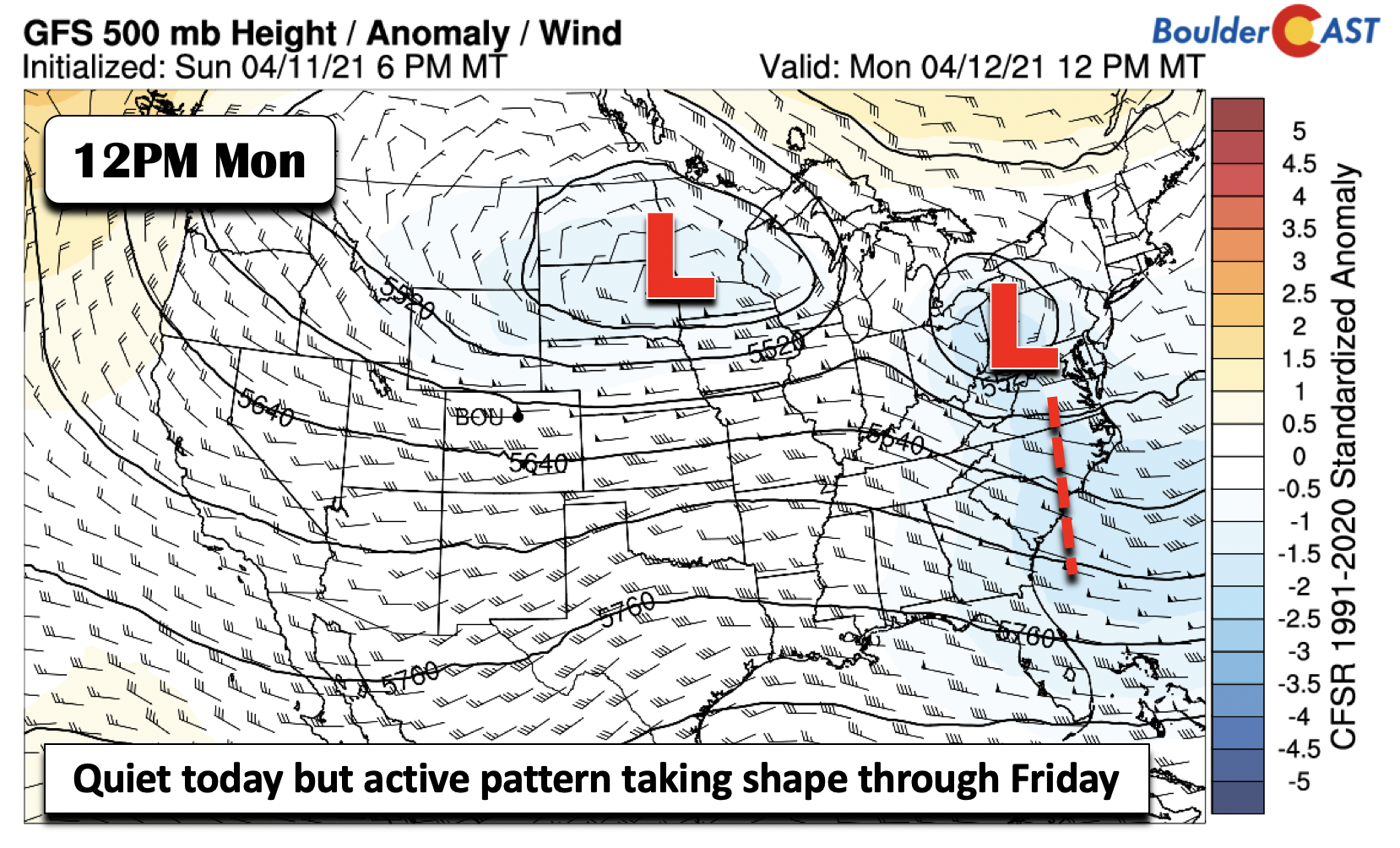
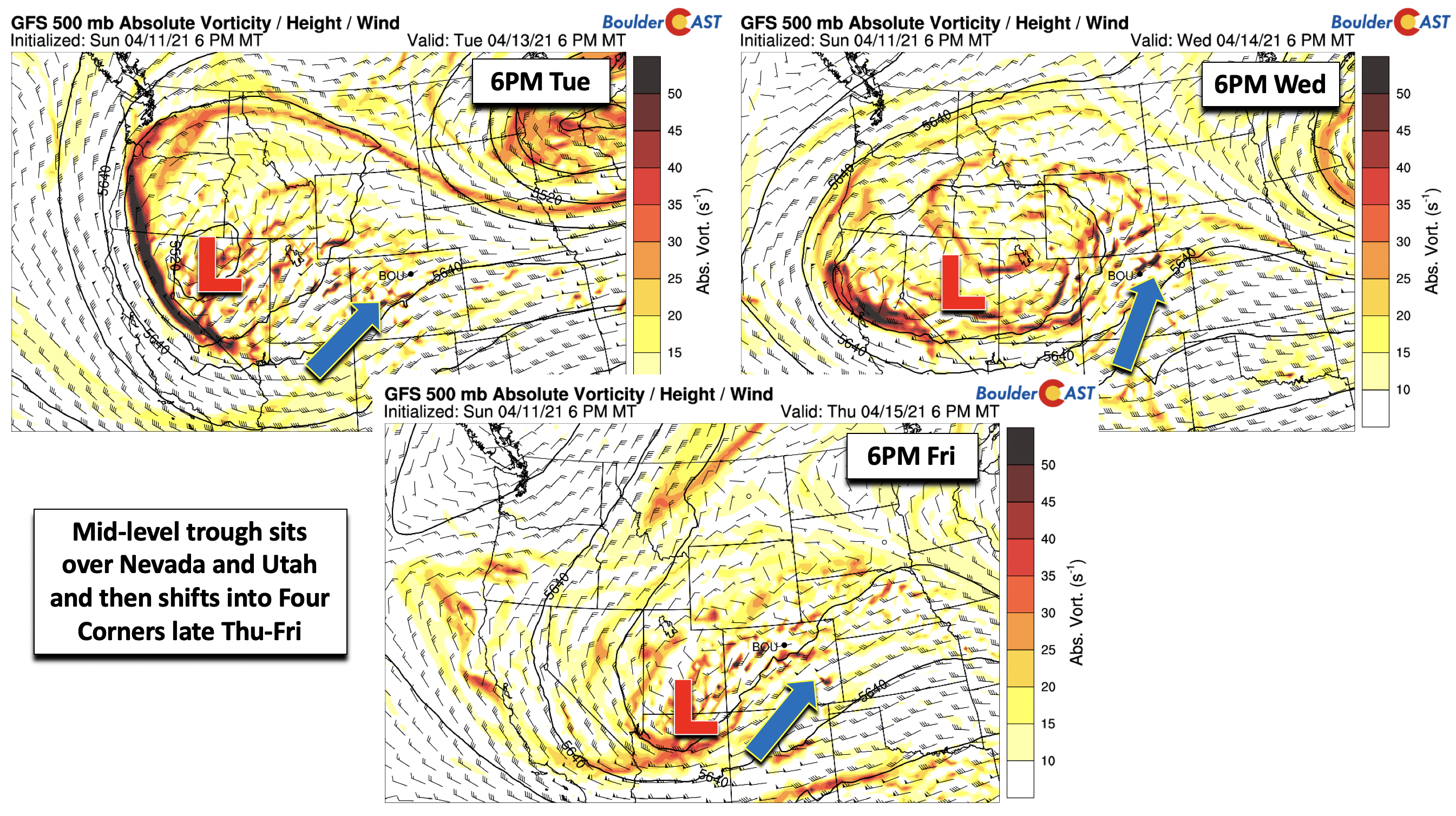
Monday will be the only quiet day of the week for the Metro area. Over the nation, we have a trough hanging out in the eastern United States, as well as one over the Dakotas, with a trough axis starting to develop over Nevada.
After brief morning sunshine, we will be under increasing clouds through the day. There will be a reinforcing shot of cooler air tonight into Tuesday, but before that happens we will still be under a northeasterly surface flow, with temperatures remaining chilly in the upper 40’s, a few degrees cooler than Sunday.
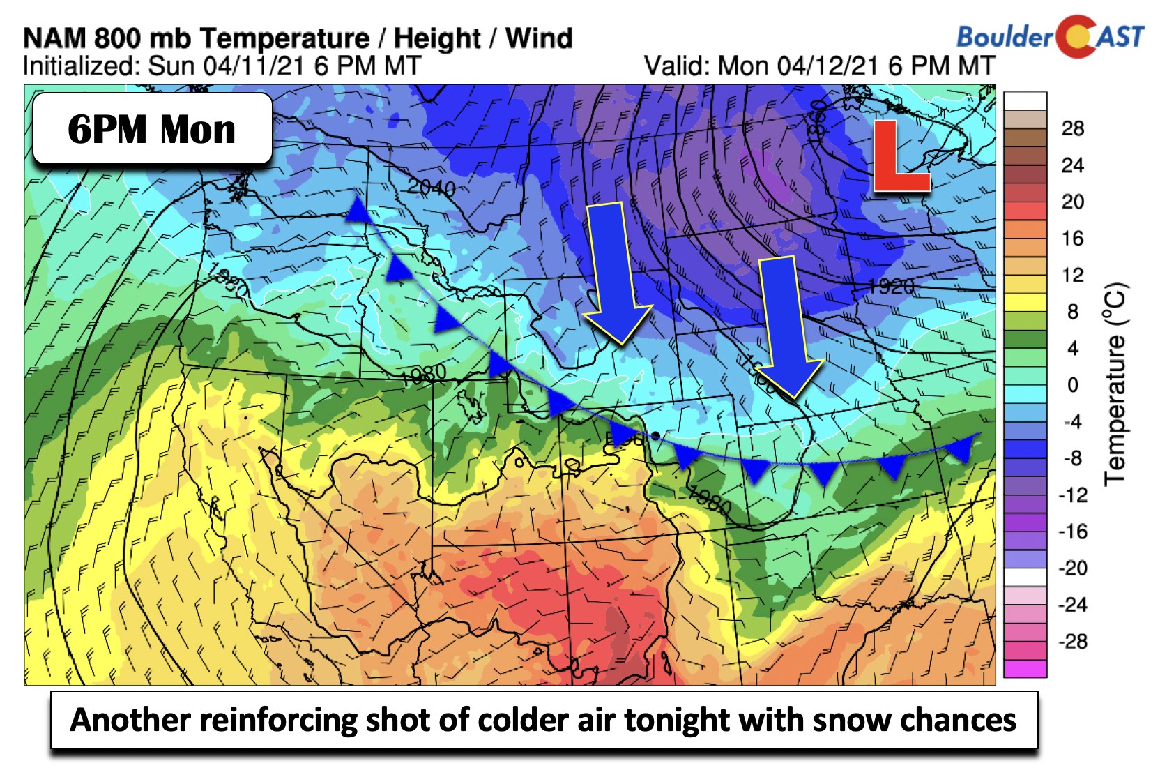
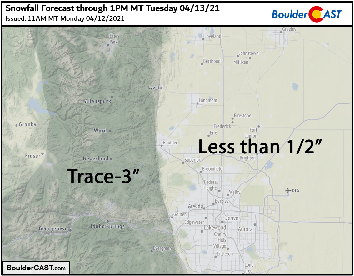
As the cold front shifts southward tonight and early Tuesday, upper-level energy with a developing mid-level low pressure over Nevada will fuel snow showers across the Denver Metro and Boulder areas into midday Tuesday. A few inches of snow are possible with this first wave in the Foothills, with mainly just a dusting or less on grassy surfaces expected across the lower elevations through Tuesday morning.
Three main waves of rain/snow the rest of the week
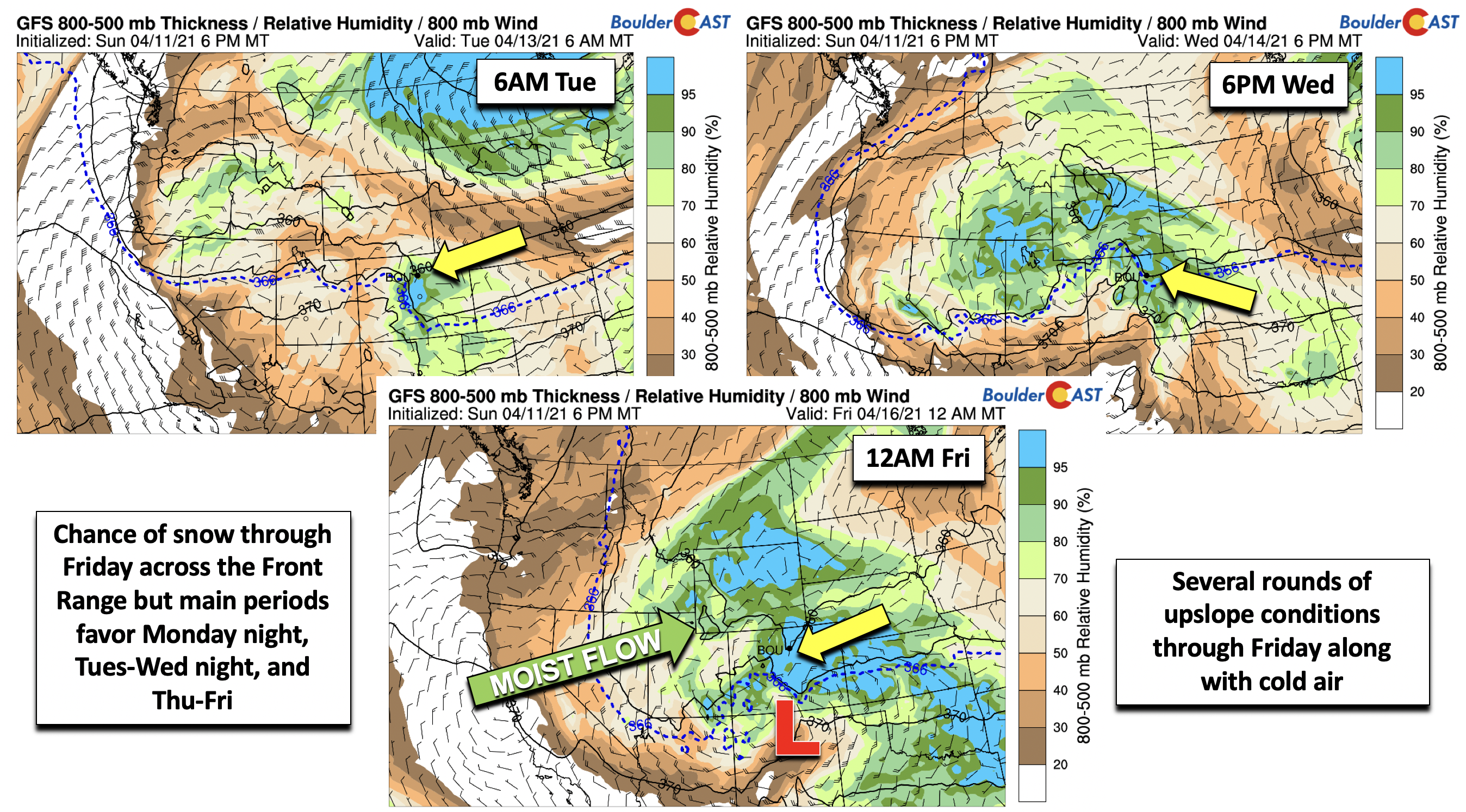
As mentioned earlier, this week won’t be an all-out period of continuous snow or rain showers. We think our chances will favor roughly three distinct periods. As shown below, mid-level low pressure over Nevada on Tuesday evening will rotate and remain there through Wednesday. By late in the week, this trough makes it way into the Four Corners. We think there are three main waves. The first wave (not counting what transpires Monday night) arrives Tuesday night with a batch of energy from the southwest, coupled to surface upslope and possibly jet forcing. A second wave arrives Wednesday night to early Thursday with mid-level energy and a surface warm front. Finally, a third wave arrives late Thursday through Friday as the system pulls to our south and east coupled to deeper upslope and colder air. Of course, any slight deviation in the storm track will make these waves even harder to pick out.
The waves show up well in the thickness and mean relative humidity plots below. Note the dashed blue line, which is a rough estimate for the rain/snow line in eastern Colorado. The wave tonight into early Tuesday is cold enough for snow, along with good upslope, but forcing is not as strong. The second wave Wednesday night to early Thursday shows the rain/snow line shifting a tad north as a surface warm front. Thus, this period we expect a mix of rain and snow given borderline temperatures. The third wave late in the week is more favorable for heavier snow than any other day with colder air, deeper upslope, upper-level forcing, and possible jet-forced snow bands, but that is quite a ways out and for now just bears watching.
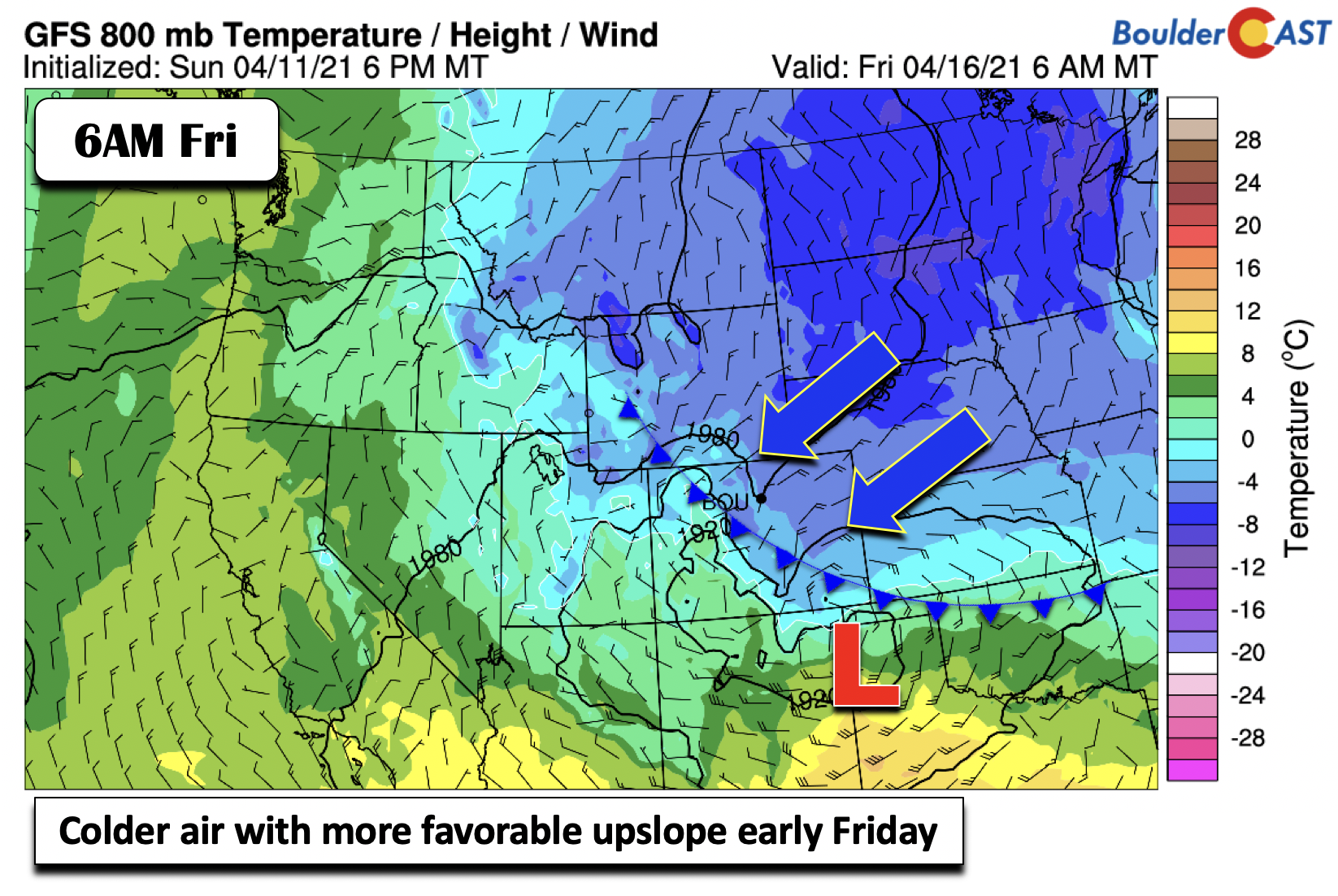
This is the deterministic GFS forecast at 800 mb (near surface) for temperature and wind early Friday. Note the colder air in place and stronger northeasterly upslope flow. Of course, this is just one model solution but is interesting and worth keeping an eye on. The snow potential Thursday night into Friday should be the main event of the week, but due to the lead time is still uncertain.
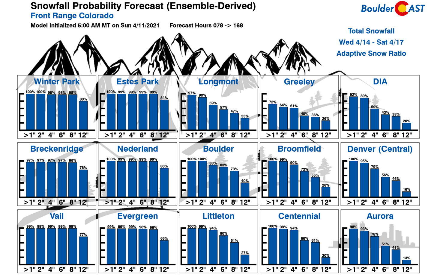
So how much snow can we expect in total this week? As mentioned earlier, we’re looking at a dusting or so Monday night. Then maybe dusting up to 3″ Tuesday evening into Wednesday morning. After that, uncertainty is much higher mid-week through Friday. Our snowfall probabilities hint that more substantial snow may be on the table during this timeframe, as shown below. These ensemble-derived probabilities indicate good chances of seeing an additional 6+” in Boulder and 4+” in Denver by Saturday. Of course, these probabilities do not take into account fully the ground temperatures or near-surface air temperatures. We will be in the 40’s most of the week, which will limit accumulations. Anything that sticks during the overnight periods will surely melt quickly over the course the following day, so the final amount of snow on the ground will likely be underwhelming. Overall, it’s a difficult forecast indeed this week specifically for snow amounts. The persistent clouds, cooler temperatures, and shot of beneficial moisture are a given, however!
Stay tuned as we begin to better nail-down the timing and impacts from each specific wave of precipitation this week.
Stay up to date with Colorado weather and get notified of our latest forecasts and storm updates:
We respect your privacy. You can unsubscribe at any time.
Forecast Specifics:
Monday: Increasing clouds with highs in the upper 40’s on the Plains and upper 30’s in the Foothills. Light snow develops overnight into early Tuesday, with a dusting of snow possible on the Plains and up to 2″ in the Foothills.
Tuesday: Spotty light snow in the morning, then mostly cloudy before another round of snow is likely Tuesday night. Highs in the middle 40’s on the Plains and middle 30’s in the Foothills.
Wednesday: Mostly cloudy with snow showers in the morning. Then a mix of rain and snow in the afternoon/evening and overnight periods. Highs in the middle 40’s on the Plains and middle 30’s in the Foothills.
Thursday: Partly to mostly cloudy with rain/snow, then snow possible in the evening and overnight. Highs in the 40’s on the Plains and 30’s in the Foothills.
Friday: Snow possible under cloudy skies. Highs in the upper 30’s on the Plains and upper 20’s in the Foothills.
Mountains: Snow showers will be present over the high country all but Monday (below). But main periods will be overnight tonight into Tuesday, Tuesday night through Wednesday, and late Thursday through Friday. However, snow showers will likely persist into the weekend as well.
Help support our team of Front Range weather bloggers by joining BoulderCAST Premium. We talk Boulder and Denver weather every single day. Sign up now to get access to our daily forecast discussions each morning, complete six-day skiing and hiking forecasts powered by machine learning, first-class access to all our Colorado-centric high-resolution weather graphics, bonus storm updates and much more! Or not, we just appreciate your readership!
.
Spread the word, share the BoulderCAST forecast!
.


You must be logged in to post a comment.