
April has been an incredibly warm month so far in the Front Range, but that will change next week as a major pattern shift takes hold. Gloomy and unsettled conditions will spread in Tuesday and beyond with daily chances for rain and snow. Due to marginal temperatures, the highest probably of significant snow accumulations will be in the Foothills, but just about everywhere will see snow at times. Let’s take a quick look at the still evolving forecast for next week.
At a Glance:
- The start of April has been extremely warm for us, but that’s about to change!
- A stalled low pressure system to our northwest will bring unsettled weather for an extended period beginning Monday night
- Snow is fairly likely across the area, but amounts will be highly dependent on temperatures, timing and elevation
- Snow amounts are uncertain across the Plains, but the higher Foothills could see more than a foot of snow
DISCLAIMER: This outlook forecast was created Saturday morning and covers the next few days. Accuracy will decrease as time progresses as this post is NOT updated. To receive daily updated forecasts from our team, subscribe to BoulderCAST Premium.

I
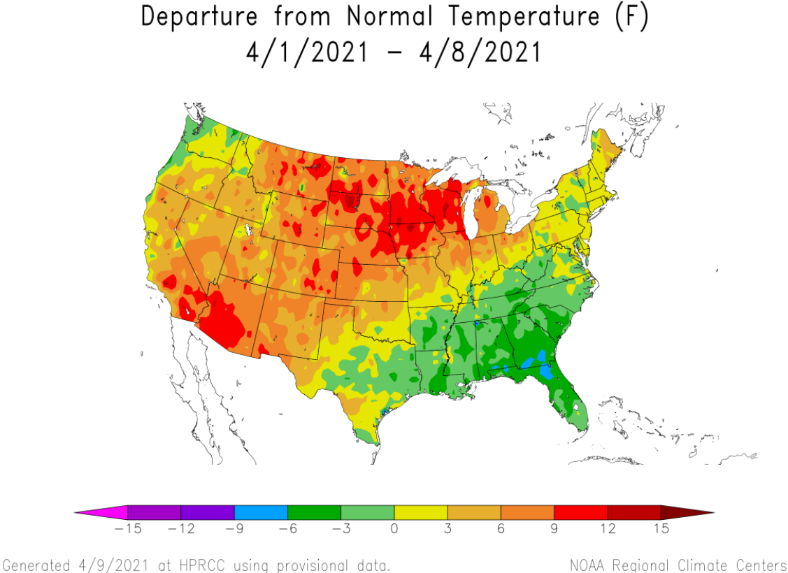
t has been a very warm start to April so far with temperatures running well above normal across the Front Range thanks to a persistent ridge of high pressure. Through April 9th, Boulder’s mean monthly temperature has been 8°F above normal, while Denver is 10°F above normal! Looking more broadly, nearly the entire western and northern three-fourths of the country have also been warmer than normal under this atmospheric setup.
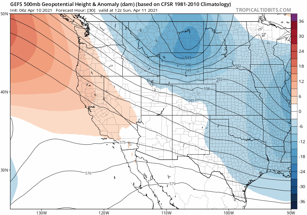
This warm pattern is finally set to crack during the upcoming week, at least for the western United States including Colorado. A slow-moving cut-off low pressure system will enter the picture on Tuesday from the Pacific Northwest and may not fully exit the region until Saturday.
We’ve seen a lot of buzz developing around this pattern shift and the associated potential for snowfall in the Front Range. And while it may be warranted, right now we should take any details with a grain of salt. These stalled cut-off lows are always a challenging forecast, especially this late in the snow season! Do you remember the lead up to and result of Snowmaggedon last month? It was caused by a similar cut-off system, but that one was much bigger, much stronger and much colder, and thus a comparatively easier forecast!
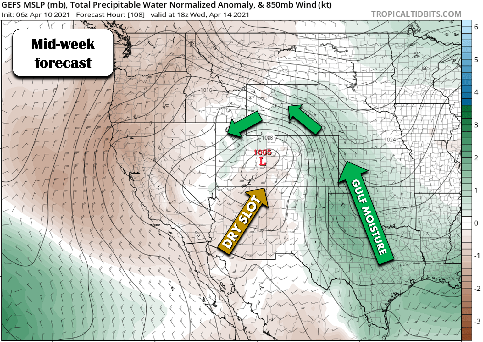
As this week’s low pressure stalls well to our north and west in Utah and Idaho through the week, a persistent influx of Gulf of Mexico moisture will get wrapped into this broad storm and inundate eastern Colorado in the process. This jump in moisture combined with frequent shortwaves rotating around the base of the trough will produce off and on unsettled conditions through much of the week ahead. This will translate into well below normal temperatures and daily chances for precipitation in Denver and Boulder.
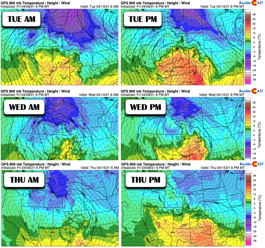
The most challenging and critical part of the forecast will lie in the precipitation type. With the storm projected to stall out to our northwest, this leaves a broad area of southwesterly flow aloft across Colorado, wrapping around the base of the system. In some cases, flow aloft will be directly out of the south. Not only is this a downslope direction; it’s also a warm one.
Furthermore, at the surface, the picture isn’t any better for snow. Best case scenario, we’d be looking at cool (but not cold) southeasterly flow near ground-level for much of the week. While this upslope direction is generally favorable for precipitation in the Denver Metro area, this time of year it’s often just a shade too warm for snow. Also, there is some indication that portions of the Front Range could shift entirely into the warm sector which would definitely be a “no-go” for snow. You can see hints of this warm air working in at the surface in the Wednesday PM panel below.
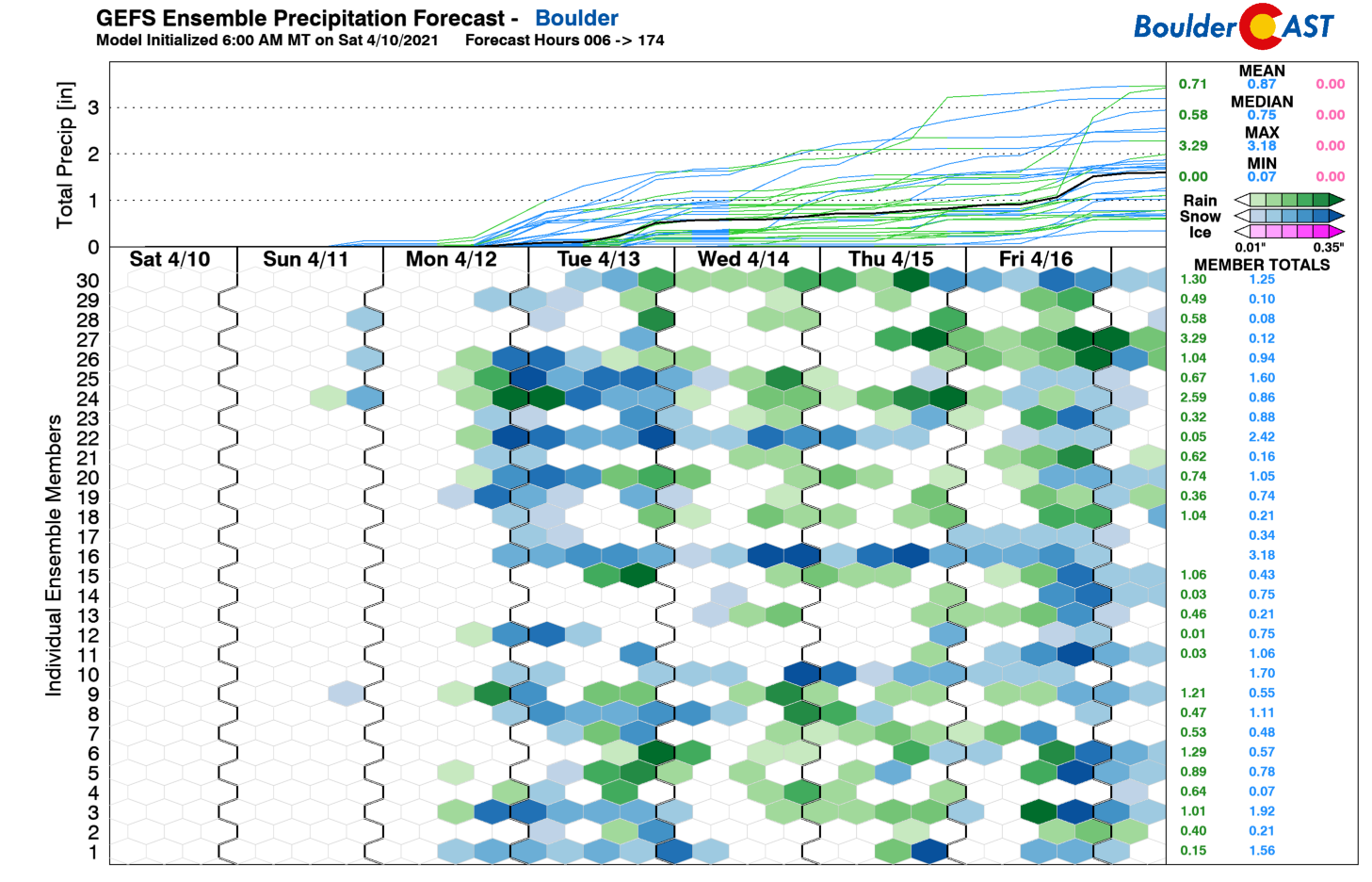
The vast majority of weather models are trying very hard right now to convince us that much of the precipitation that falls over the next week will be in the form of snow (see the GFS ensembles below), but we know better. More than likely, this setup will be too warm for the lower elevations, with daytime precipitation falling in the form of rain or a rain/snow mix through the week. In the rare situations where it turns to all snow during the day, it will be a very wet snow with accumulation being limited by above freezing temperatures at the surface and a very warm ground.
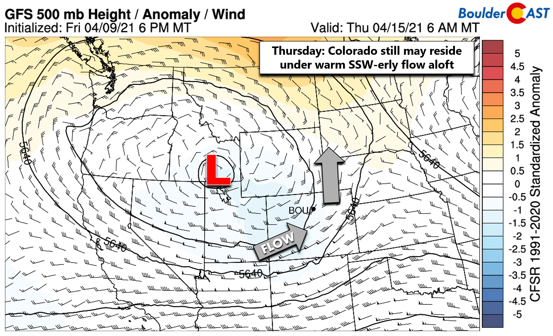
However, during the nighttime hours it will be a different story as temperatures cool close to the freezing mark and snow levels drop. The problem is, with this type of cut-off setup and the long duration of the expected unsettled conditions, we just don’t know yet the timeline of the storm and when exactly to expect any flare-ups in precipitation. The position of the storm is particularly uncertain after Wednesday when it could still be over Idaho, might eject into the Midwest, or could even split into two separate cut-off lows causing an even more chaotic situation. Uncertainty is very high right now from mid-week onwards in regards to this storm so the forecast is still in limbo.
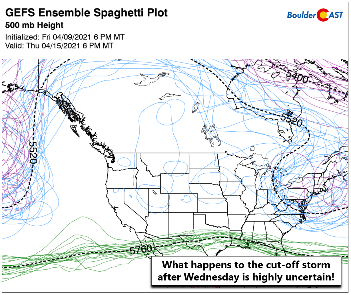
Each blue circle over the western United States represents a ensemble forecast position for the storm on Thursday evening. VERY poor agreement is noted.
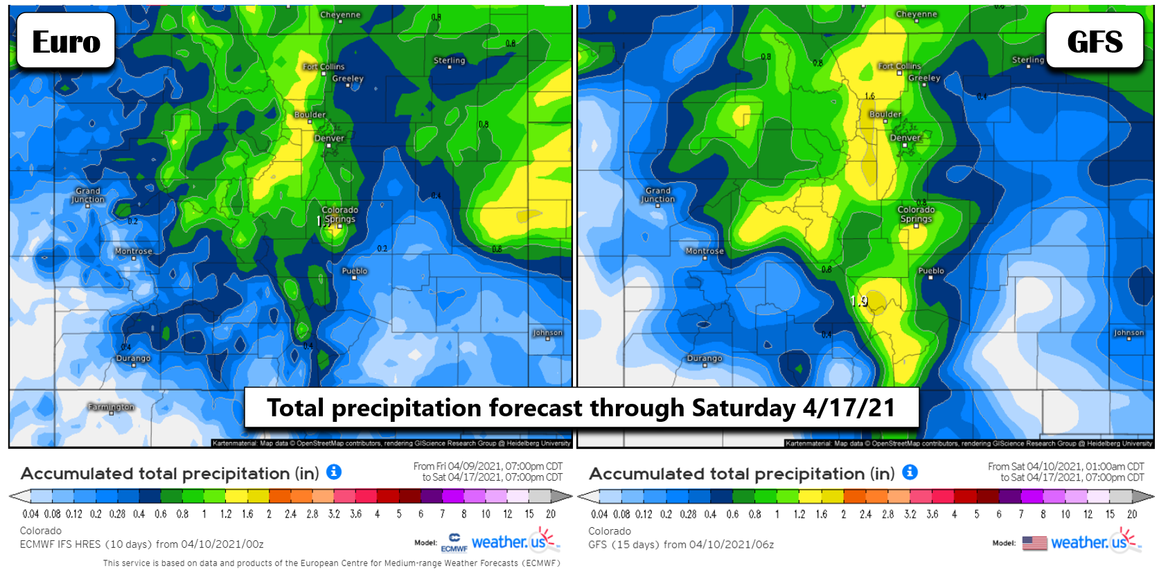
Despite this late-week uncertainty, the GFS and Euro models show surprisingly good agreement in the precipitation outlook for the week, with anywhere from 0.75″ to 1.5″ falling across the Denver Metro area through next Saturday April 17th (highest in the Foothills).
So how much snow should we expect from all this? It’s very hard to say this early in the game with so much uncertainty in the timing, temperatures, and storm positioning. Our “best guess” snow forecast right now can be gleaned by taking those model precipitation forecasts above at face value and assume that half of that liquid will fall in the form of rain or rain/snow mix during the daytime. This leaves around 0.4 to 0.8″ of liquid for nighttime snowfall, which would roughly equate to 3 to 10″ of snow for the lower elevations (spread over a handful of days). Given the colder temperatures in the Foothills, double this amount may be possible with even daytime precipitation falling as snow above 7000 feet. Under southeasterly surface flow, the Foothills of Larimer County, more so than Boulder County, could do very well this week with heavy snow totals.
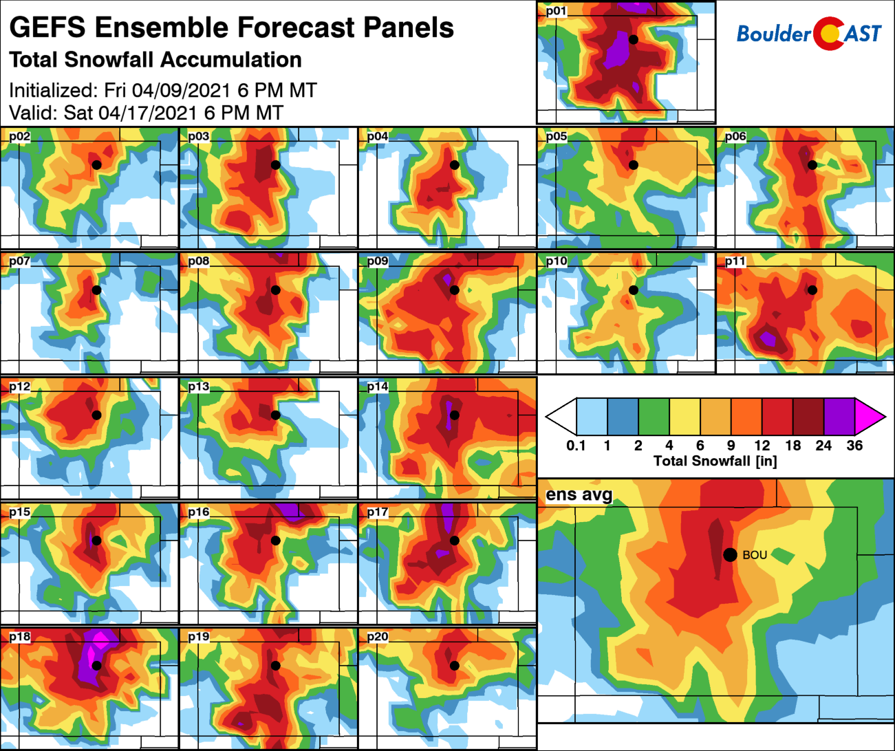
All of the GFS ensemble members show snow in the Denver area this week, but amounts vary greatly based on timing and temperatures. The ensemble average predicts between 6 and 12″ for the Metro area, with 12+” in the Foothills.
Ultimately, the main take-away right now is that it will be a much cooler and unsettled week ahead, with lots of cloud cover and daily chances for rain and snow. Be prepared for periods of accumulating snow as well, mainly during the overnight and morning stretches on the Plains. Given the milder temperatures, travel impacts will be limited across the lower elevations, though things could get ugly in the Foothills. Snow or not, this moisture will be great for our state which is still plagued with drought. We’ll post an update to the forecast Monday morning. Enjoy the rest of this very sunny weekend. You won’t be seeing much sun next week!
.
Stay up to date with Colorado weather and get notified of our latest forecasts and storm updates:
We respect your privacy. You can unsubscribe at any time.
Help support our team of Front Range weather bloggers by joining BoulderCAST Premium. We talk Boulder and Denver weather every single day. Sign up now to get access to our daily forecast discussions each morning, complete six-day skiing and hiking forecasts powered by machine learning, first-class access to all our Colorado-centric high-resolution weather graphics, bonus storm updates and much more! Or not, we just appreciate your readership!
.
Spread the word, share the BoulderCAST forecast!


You must be logged in to post a comment.