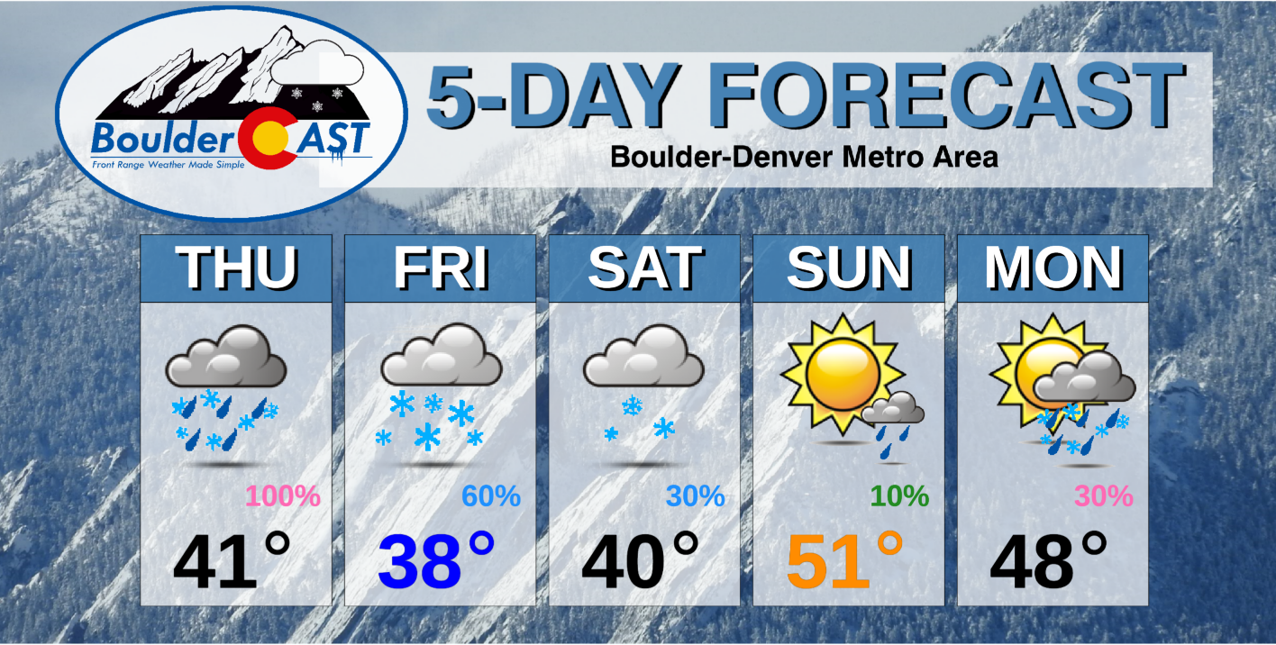
The pesky trough that produced cold and gloomy weather all week long for us will finally push across Colorado Thursday night into Friday. This passage will produce widespread showers from late afternoon Thursday into the overnight. It will begin as rain, but quickly change to snow with several inches of accumulation likely for the Denver Metro area. Let’s take a closer look at this storm and where the most snow will fall.
At a Glance:
- The pesky trough that brought gloomy weather all week will finally push across Colorado Thursday night into Friday
- Widespread showers will push off the terrain this afternoon through the evening, with rain quickly changing to moderate snow for the Metro area
- Light snow will linger well into Friday, with total accumulations of 2 to 6″ expected
- Unseasonably cold and somewhat unsettled weather will linger through the weekend and likely much of next week as well
DISCLAIMER: This outlook forecast was created Saturday morning and covers the next few days. Accuracy will decrease as time progresses as this post is NOT updated. To receive daily updated forecasts from our team, subscribe to BoulderCAST Premium.

D
espite being a largely unsettled week so far, we’ve had little to show for it. Boulder has reported just 0.21″ of precipitation and 1.4″ of snow through Thursday morning. Denver International Airport has reported nothing yet…not a single raindrop or snowflake all week long! Just to the west in the Foothills, 5 to 10″ of snow has fallen this week already from Nederland to Estes Park!
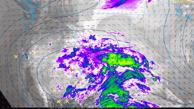
The overall lack of apprecipitable precipitation across the lower elevations is mainly due to a persistent dry layer clinging to the surface over Boulder and Denver which ate up much of the precipitation before it was able to reach the ground through the week. This will change later today, however. As we discussed with you all the way back on Monday, tonight was expected to be the “main event” of the week, and that will indeed be the case. The broad and vigorous area of low pressure which has made for a cool and gloomy week in Colorado is still situated to our west. As of Thursday morning, the low pressure is spinning just to the west of the Great Salt Lake. Ahead of the storm, southwest flow is spreading in elevated moisture and cloud cover to all of Colorado.

GOES-East infrared satellite animation from Thursday morning. 500mb height and winds are overlaid.
As we move through the day into tonight, the southern lobe of this low pressure will push directly across northern Colorado.
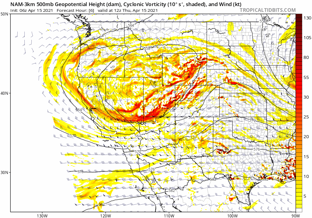
NAM 500mb height and vorticity forecast animation from Thursday morning into Friday morning
This fairly northern storm track will position the best upslope across Wyoming with this event, with more northerly flow overall around Boulder and Denver. Thus, the heaviest snowfall totals will unfortunately be well to our north around Cheyenne and in western Nebraska.
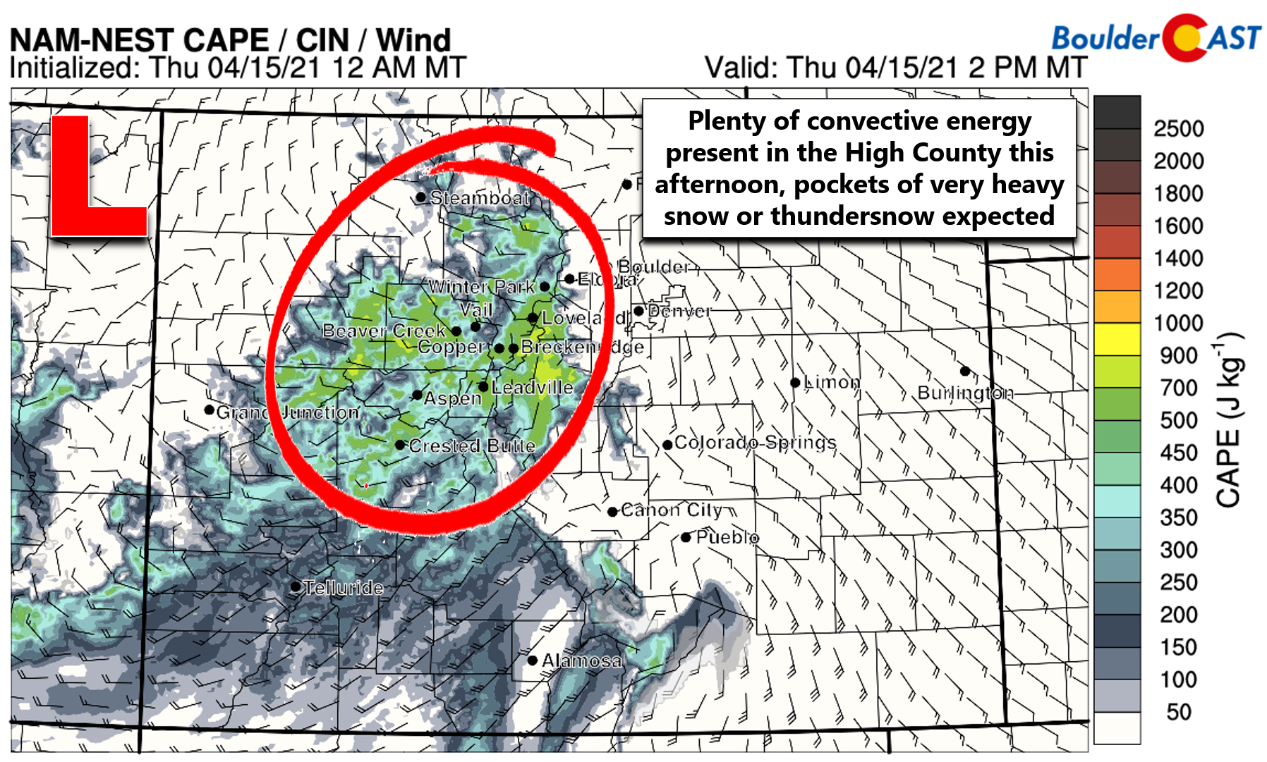
Don’t worry, though. We’ve got other mechanisms to force snowfall today. The colder core of the low itself will be spreading into the area through the afternoon. This cold air aloft combined with April sunshine in the Mountains will spawn showers and thunderstorms this afternoon.
These widespread showers are expected to advect eastward across the Denver Metro area by late afternoon into early evening. The result will be a period of rain/thunder changing to moderate snow rather quickly near or before rush hour this evening. Roadways will initially be just wet, but may become a little slushy as the evening progresses and temperatures cool. Rush hour should be mostly okay, but do watch out for pockets of heavier snow causing some slick spots. The dashed blue line below is a rough approximation for the rain/snow line at 6PM this evening. It will continue to push south and east through the nighttime hours.
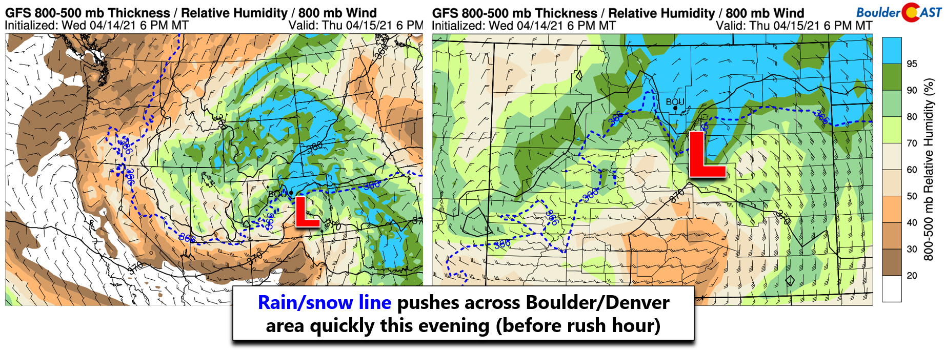
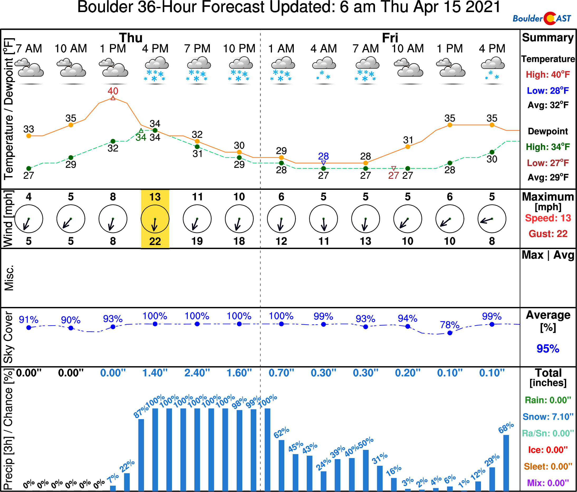
The threat of moderate to heavy snow will be possible through about 9PM in the Denver Metro area, after which that concern will exit east and impact portions of far northeastern Colorado. Lighter snow will linger through the overnight and well into Friday morning under weak upslope and large-scale lift from the passing low pressure. A rough timeline of the storm is shown below in Boulder. Note the timing on the precipitation, the swift change-over from rain to snow (if it even rains at all) and the temperatures which quickly fall below freezing this evening and then into the 20’s overnight which will make for a slick morning rush hour on Friday.
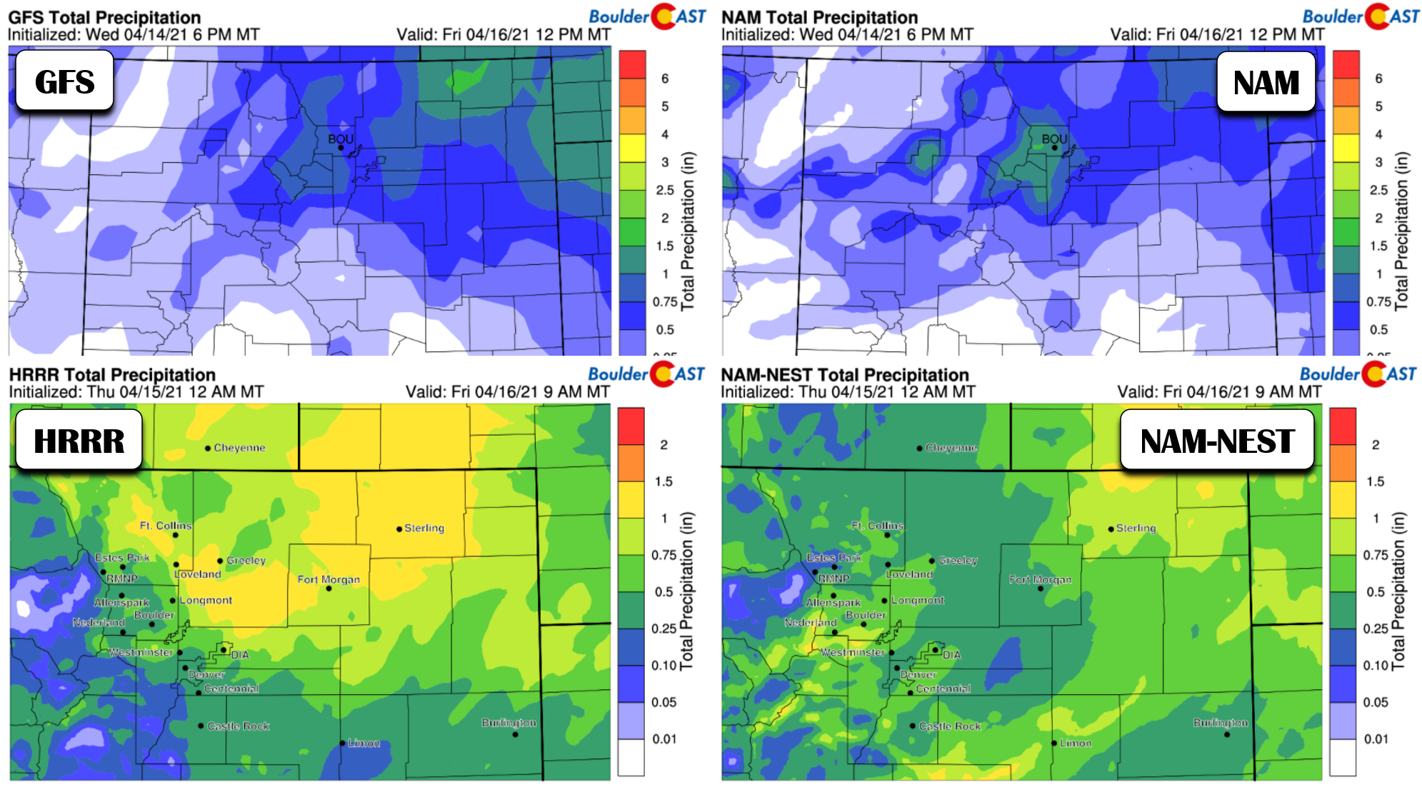
The weather models are in fair agreement for precipitation amounts from this event. However, there are some differences, likely due to the positioning and amount of convective showers this evening which can be difficult for models to pinpoint in a colder storm such as this. We’re generally expecting around 0.5″ of moisture from this system in the Denver Metro area, though a little more or less is also possible.
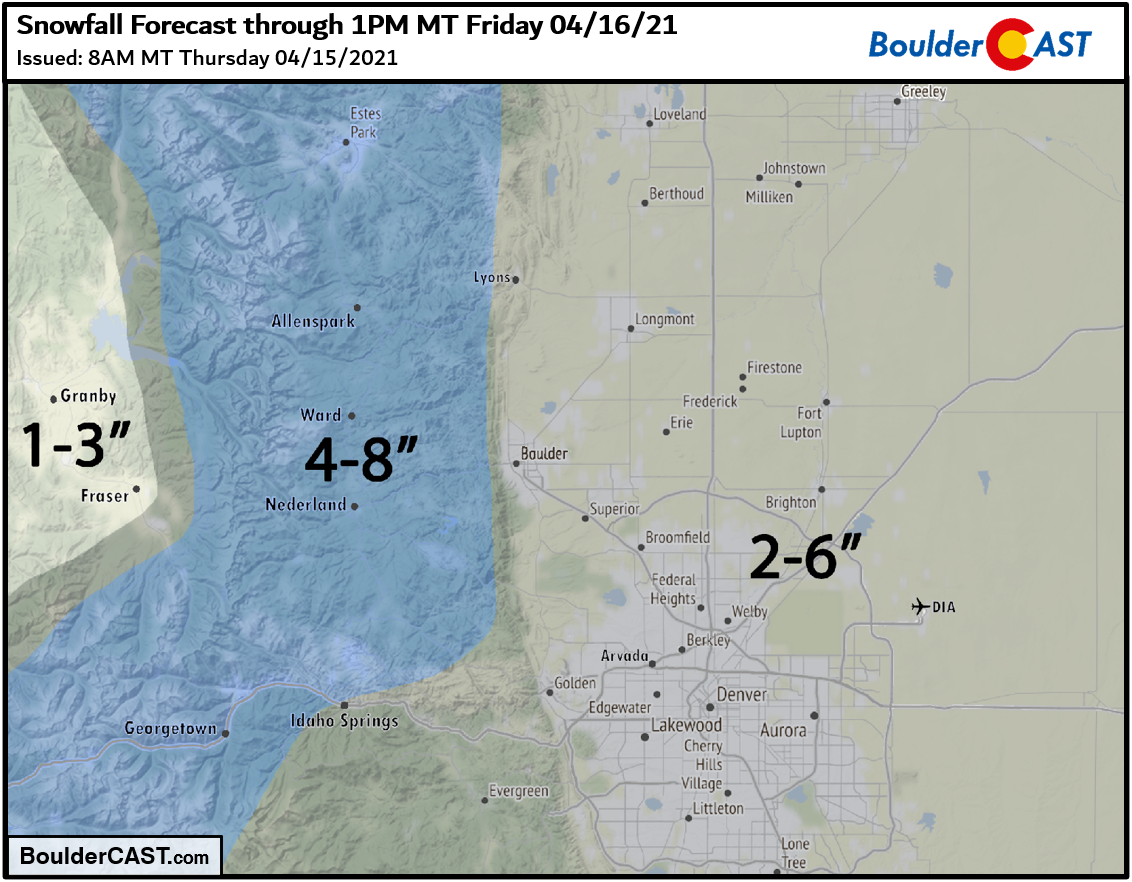
We’re anticipating snow ratios to remain at or slightly below 10:1 from this event, which is completely normal for mid-April winter weather. It’s the sloppy snow time of year! Considering the chance for a brief period of rain at the onset and how wet the snow will be thereafter, most of the Denver Metro area should pick up several slushy inches of snow this evening and overnight, generally 2-6″but with some 8″ totals not out of the question depending on how the heavier showers materialize this evening. Going up in elevation, look for a solid 4-8″ in the Foothills where it will be colder. Our snowfall forecast map for the event is shown below.
Despite light falling snow lingering through the day Friday, we’re not expecting any additional accumulation during the day as warm temperatures will cause melting of the falling snow and of the snow already on the ground. The April sun, even through thick clouds, will be more than enough to melt away most or all of the snow during the day. What you wake up to on Friday will generally be what you get. As mentioned, the morning rush hour on Friday could be slippery so do use caution. Winter Weather Advisories have been issues for all of northeast Colorado, Plains and Foothills alike. Temperatures will top out in the upper 30’s Friday with on-and-off light snow through the day.
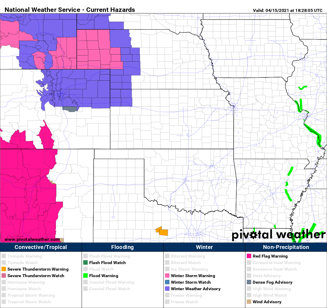
Current highlights as of Thursday afternoon
The cool and unsettled pattern will hold through Saturday with light snow lingering. We may see some brief sunshine Sunday before rain and snow return again early next week.
Looking longer term, the cool and troughy pattern is predicted to hold over the center of the country, including eastern Colorado. Our average high temperature this time of year is in the middle 60’s. We won’t be anywhere near that for the next seven to ten days…
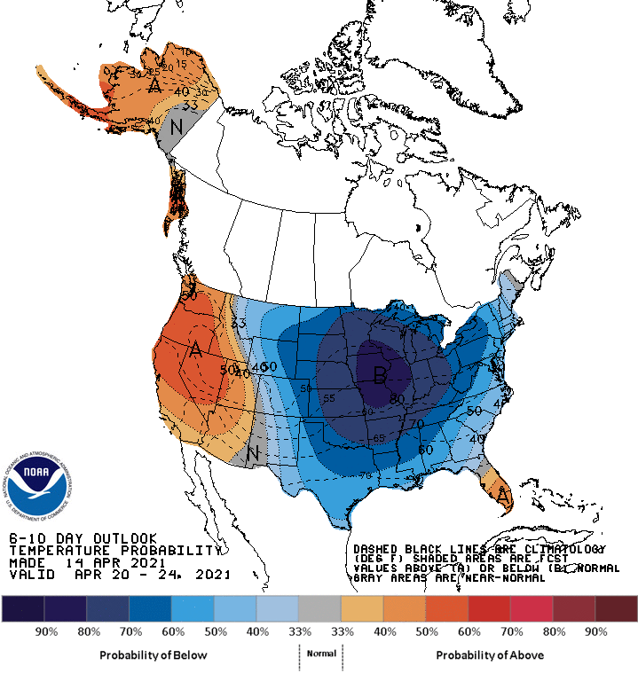
CPC temperature outlook for April 20 – 24 (next week). Colder than normal temperatures are likely over our area.
Stay up to date with Colorado weather and get notified of our latest forecasts and storm updates:
We respect your privacy. You can unsubscribe at any time.
Help support our team of Front Range weather bloggers by joining BoulderCAST Premium. We talk Boulder and Denver weather every single day. Sign up now to get access to our daily forecast discussions each morning, complete six-day skiing and hiking forecasts powered by machine learning, first-class access to all our Colorado-centric high-resolution weather graphics, bonus storm updates and much more! Or not, we just appreciate your readership!
.
Spread the word, share the BoulderCAST forecast!


You must be logged in to post a comment.