
For the third time in less than two weeks a significant spring storm will spread a hefty helping of precipitation to the Front Range in the coming days. Initially it will be all rain across the Plains Sunday and during the day Monday, but we are concerned about a change-over to snow Monday night into early Tuesday for the lower elevations. Let’s take a look at the storm timeline and how much May snow everyone can expect!
Category: Forecast (Page 79 of 169)

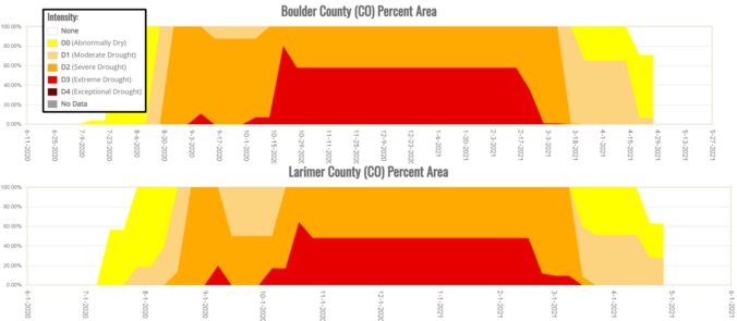
We begin very cold, rainy and snowy for some, but things will improve through the week slowly with a chance at hitting 80 degrees again by week’s end. Overall, though, the week remains fairly unsettled which is typical for this time of year and is welcomed considering the lingering drought. Let’s take a look at the forecast.
After our first real taste of summer the last few days, the weather will revert to more seasonal conditions Sunday into Monday. For Front Range Colorado in early May, that means severe weather, soaking rainfall and snow in the higher terrain. Let’s take a look at the latest on the stormy, soggy and snowy weather about to unfold!
Change is happening NOW! After a few days close to 80 degrees in Boulder and Denver, temperatures will tumble today into the 50’s with widespread precipitation developing through the day Tuesday and lingering well into Wednesday. The initial threat will be thunderstorms Tuesday afternoon, but that concern will shift to heavy snow in the Foothills Tuesday evening and night. Let’s take a quick look at the forecast for this spring storm!

The week begins right where it left off from the weekend with highs near 80 degrees on Monday. A deep trough approaches Tuesday into Wednesday with widespread rain showers and chilly temperatures expected. Don’t worry though, by the end of the week a large dome of high pressure will return sending highs back into the 80’s just in time for the weekend.
A late-season Arctic cold front ushered in bitter cold temperatures on Monday morning and eventually a dumping of fluffy snow for the entire Front Range Monday evening. We review the snow totals and record cold temperatures. We also give our preliminary snowfall forecast for the next system in the pipeline set to arrive during the day Wednesday.
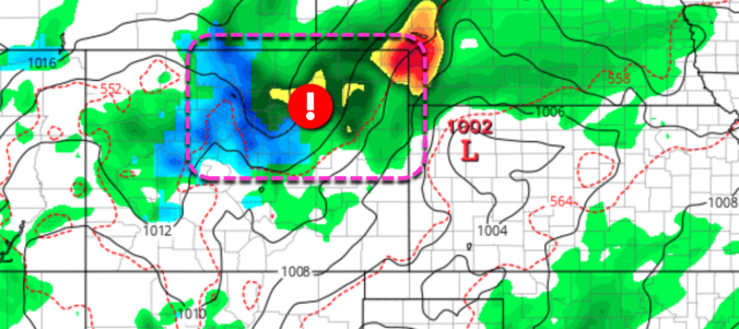
Updated Wednesday 4/21/21 7:00AM: Amended snowfall forecast map. For more details and additional discussion, check our latest Premium forecast from Wednesday morning HERE.

This week kicks off with a bang as widespread moderate to heavy snow will develop Monday afternoon and evening across the Front Range as an impressive but ultimately quick-moving Arctic cold front impacts the region. Watch out for deteriorating travel conditions Monday afternoon into Monday night. Another storm will arrive around mid-week with additional snowfall accumulations likely. Our weather will remain unsettled heading into the weekend, but with more rain than snow expected. Read on for our complete forecast of the week ahead.

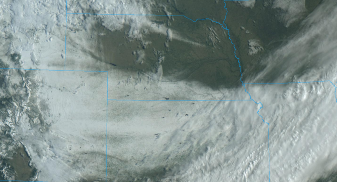
Heavy wet snow fell across the entire Front Range Thursday evening and lingered into early Friday with widespread tree damage being reported. How much snow fell and why was the tree damage so extensive? When is the next snowstorm taking shape? Let’s take a look.

Live View of Boulder

Current Conditions

Live Radar

Latest Smoke Forecast

Recent Premium Posts

BoulderCAST Daily – Wed 07/15/26 | The Ridge Rules the Rockies as Hot, Dry Pattern Holds Firm
🔥 Heat dome setup continues — A strong, stationary 500 mb ridge keeps …
BoulderCAST Daily – Tue 07/14/26 | The Front Range Continues to Bake Under Expansive Ridge
🔥 Heat streak continues — Boulder hit 97°F for the third time in …
BoulderCAST Daily – Sun 07/12/26 | Hot weather for a good chunk of the coming week
🥵 🔥 Heat for a good chunk of the week: Upper 90s through …
3-Day Forecast

Trending Content

© 2026 Front Range Weather, LLC