

Adding in the few inches that fell on Thursday, Boulder has now notched nearly two feet of snowfall in the month of January, the most since 2014. This recent snow event was just one of many small winter storms to impact the Front Range in the weeks following the devastating Marshall Fire. Colorado has seen slight drought improvement, but there is definitely much more needed. In this update we discuss the recent snow totals, how January as a whole is shaping up, the locations that are seeing drought conditions improve, why La Niña will make further recovery more challenging and much more.
At a Glance:
- 1 to 6″ of snow fell across the area on Thursday, the second bout of heavy accumulating snow to bump into the morning commute this past week
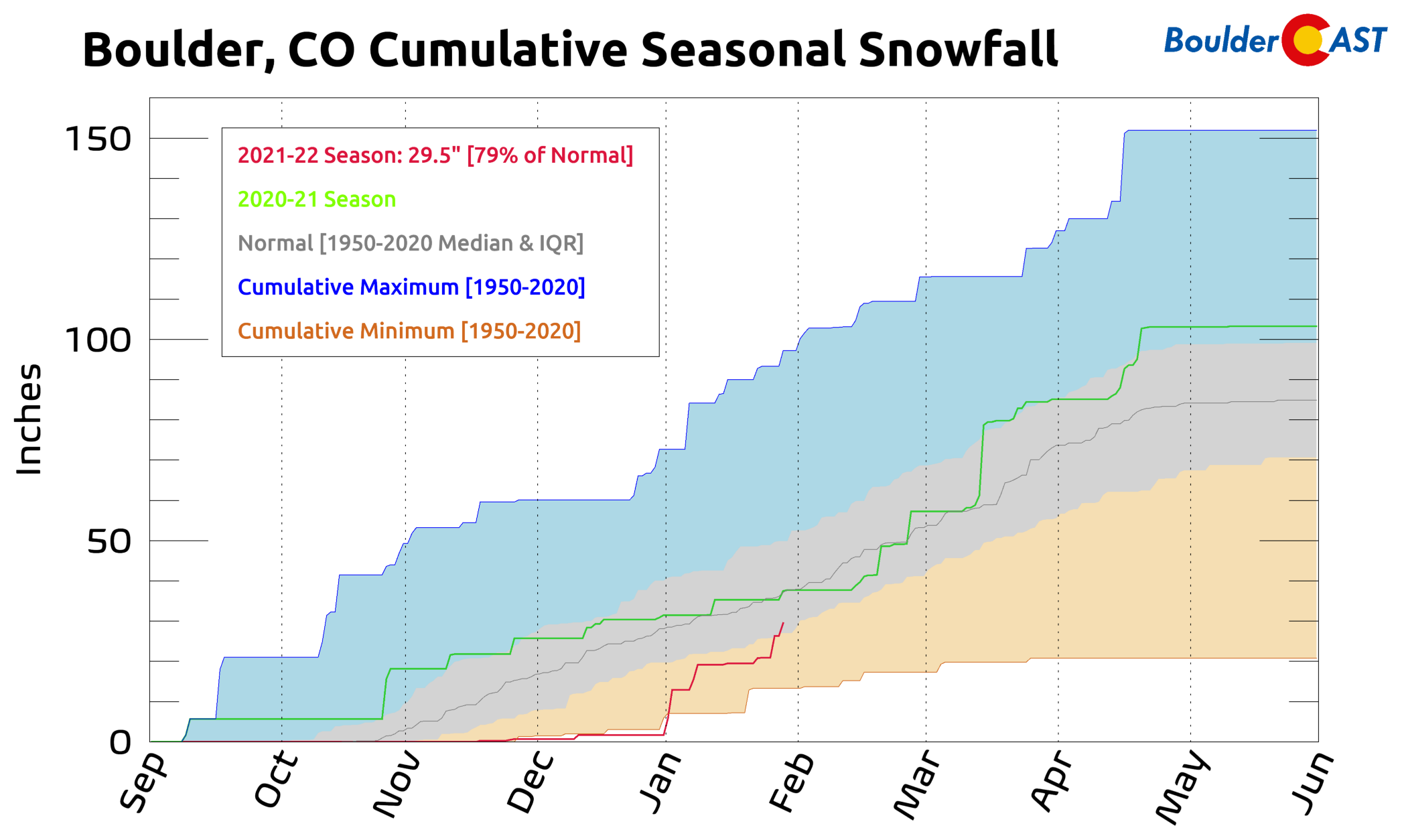
- With so many frequent light snow events of late, Boulder now has 79% of normal snowfall for the season
- Drought has improved slightly in both the Mountains and Denver Metro area in 2022
- We have a chance at seeing “normal” snow this season, but it will be an uphill battle with the ongoing La Niña
Thursday’s snow totals
For the second time in three days, the morning commute was interrupted by a burst of moderate to heavy snowfall in the Denver area. Thursday’s snow began a little later than Tuesday’s which spared most of the early-bird commuters this second time around. However, if you were late to the game you likely ran into big fluffy snowflakes restricting visibility and covering the roadways in spots.
It took awhile for the lower atmosphere to moisten up Thursday morning, but when it did, the snow really started to come down. One of our followers was surprised by one aspect of snowfall we brought up on social media. That is, snowflakes that are detected by the radar beam 2000+ feet up in the atmosphere can take 10 or more minutes to reach the ground since big flakes only fall at a rate of a couple vertical feet per second. Thursday morning allowed us to see this in action as extremely high radar returns were indicated over Boulder (heavy snow and/or giant flakes), but basically nothing was happening at ground-level!
And now it's dumping!
Big snowflakes fall at approx 3 vertical feet per second. What is shown on radar 2000+ feet up will take 10+ minutes to fall to the surface.
— BoulderCAST Weather (@BoulderCAST) January 27, 2022
Several minutes later, however, madness ensued as giant clusters of dendrites started raining down — some of them as big as quarters! Below was the view from CU Boulder campus during this time. Look at the size of those flakes! The burst of moderate to heavy snow lasted just a couple of hours from mid to late morning before everything came to a close in the afternoon and the sun quickly came out — Colorado weather at its absolute finest!
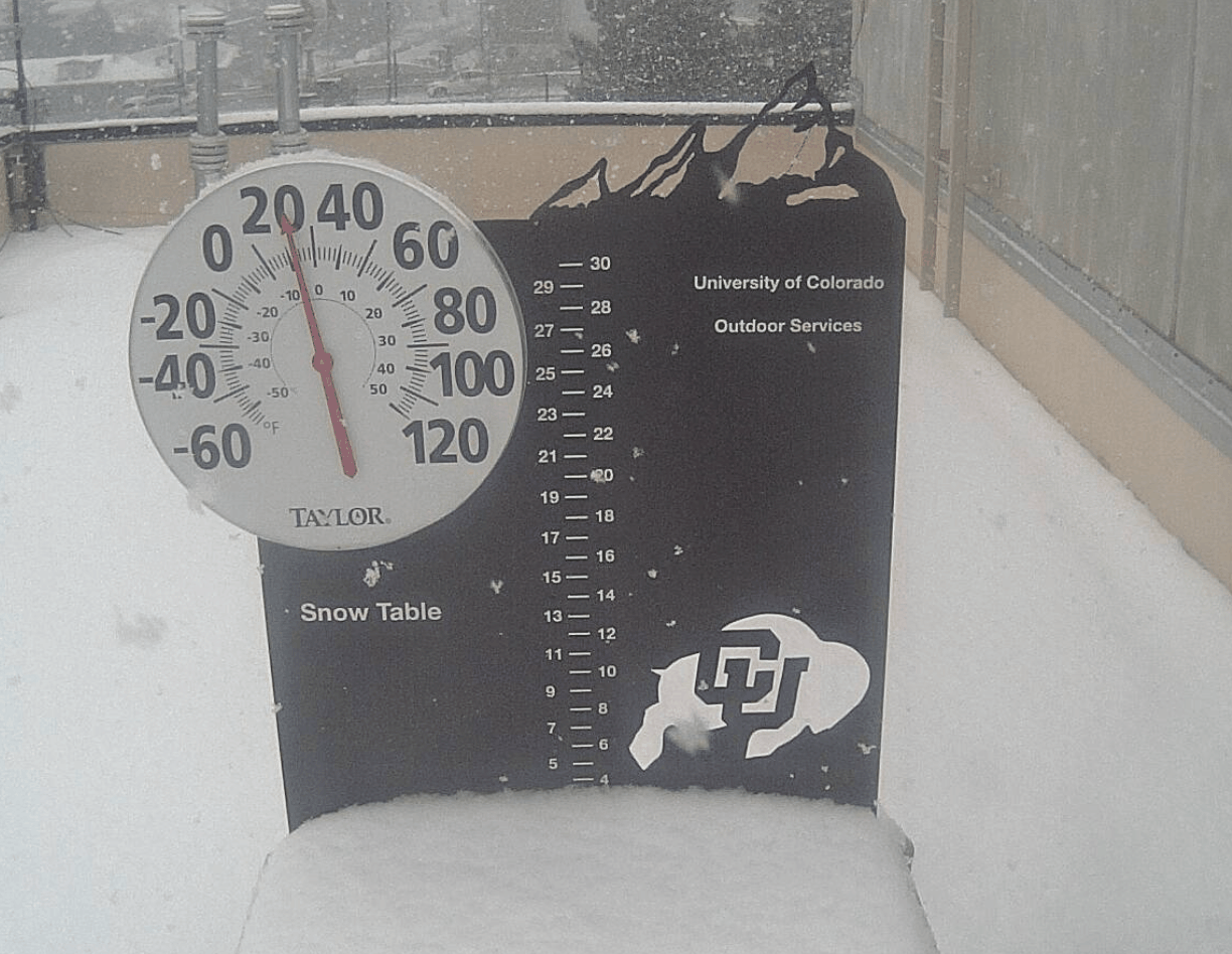
View from Boulder around 9AM Thursday (1/27/22) as heavy snow fell
Our snowfall forecast map for this event is shown below with snow totals overlaid. Green values are where our forecast verified correctly to within one inch. Red totals were a bust (or in this case, a boom!). Storm totals generally ranged from 2 to 4″ across the Denver Metro area, with 2 to 6″ in the Foothills — most spots ended up within our forecast ranges. Officially Boulder reported 3.2″ of snow, while Denver received just a tad less at 2.8″.
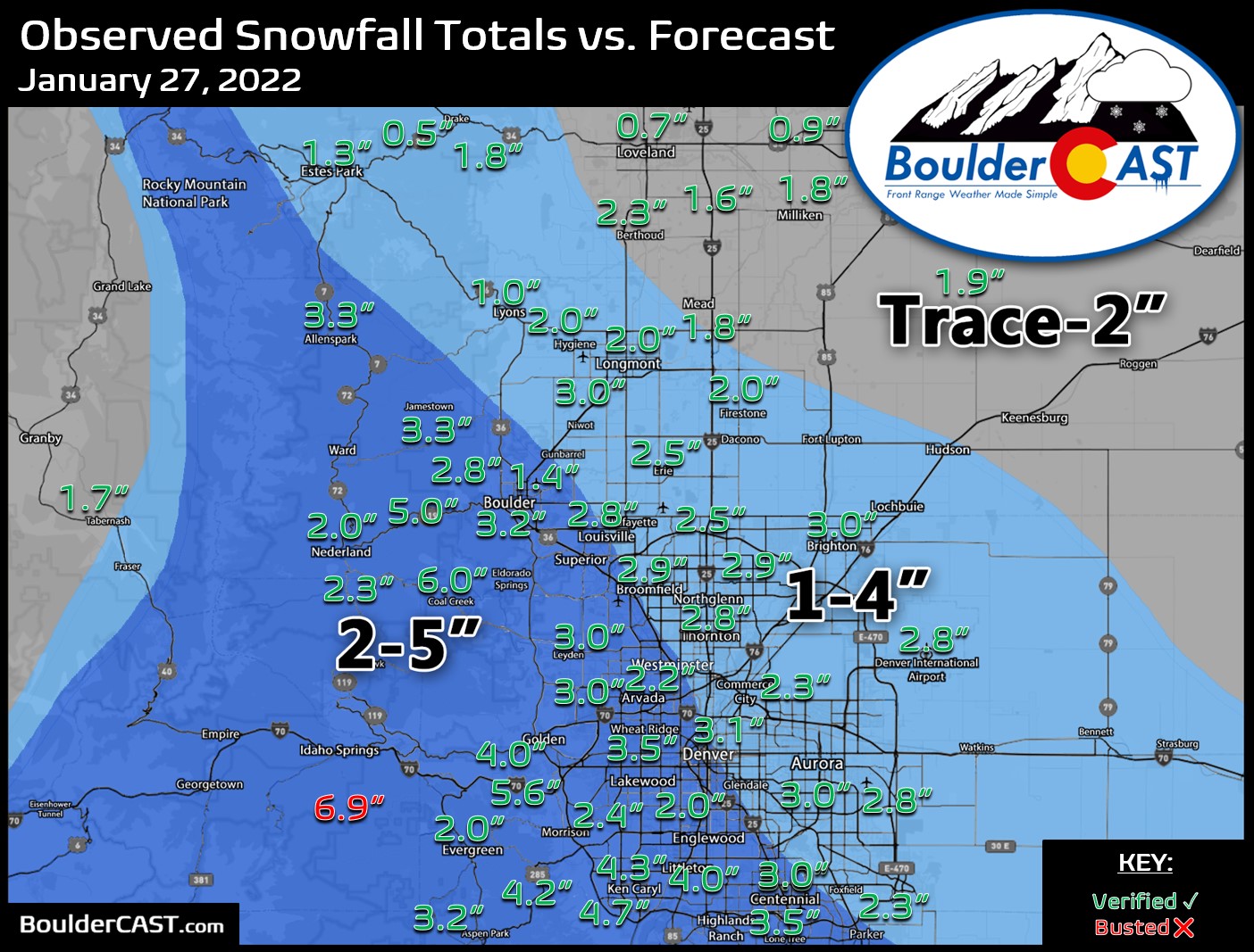
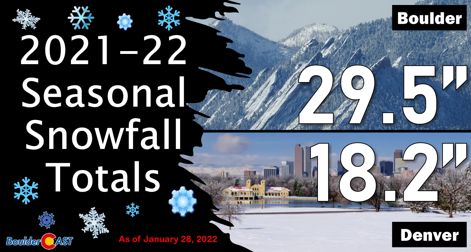
Seasonal snowfall so far for Boulder and Denver is up to 30″ and 18″, respectively.
The fast and furious start to 2022 snowfall
After the incredibly dry and warm autumn which culminated with the devastating Marshall Fire in late December, 2022 has changed tune and thus far has brought much improved conditions with a slew of winter weather systems impacting the area during the month of January — generally one or two a week.
Up until the New Year’s Eve snowstorm, Boulder and Denver were rocking their all-time lowest cumulative snowfall for any season. Since then, however, things have really started to turn a corner with just shy of two feet of snow falling in January. This is the most since 2014 for Boulder — a rebound we desperately needed.
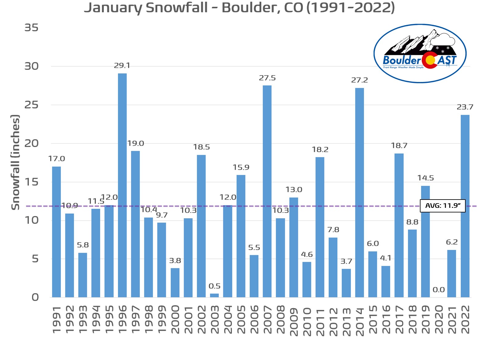
Here’s a look at the timeline of Boulder’s 2021-22 snowfall so far. At 29.5″ through January 28th, we’re at 79% of the long-term median. Not bad considering we were dangerously close to 0% just a month ago!
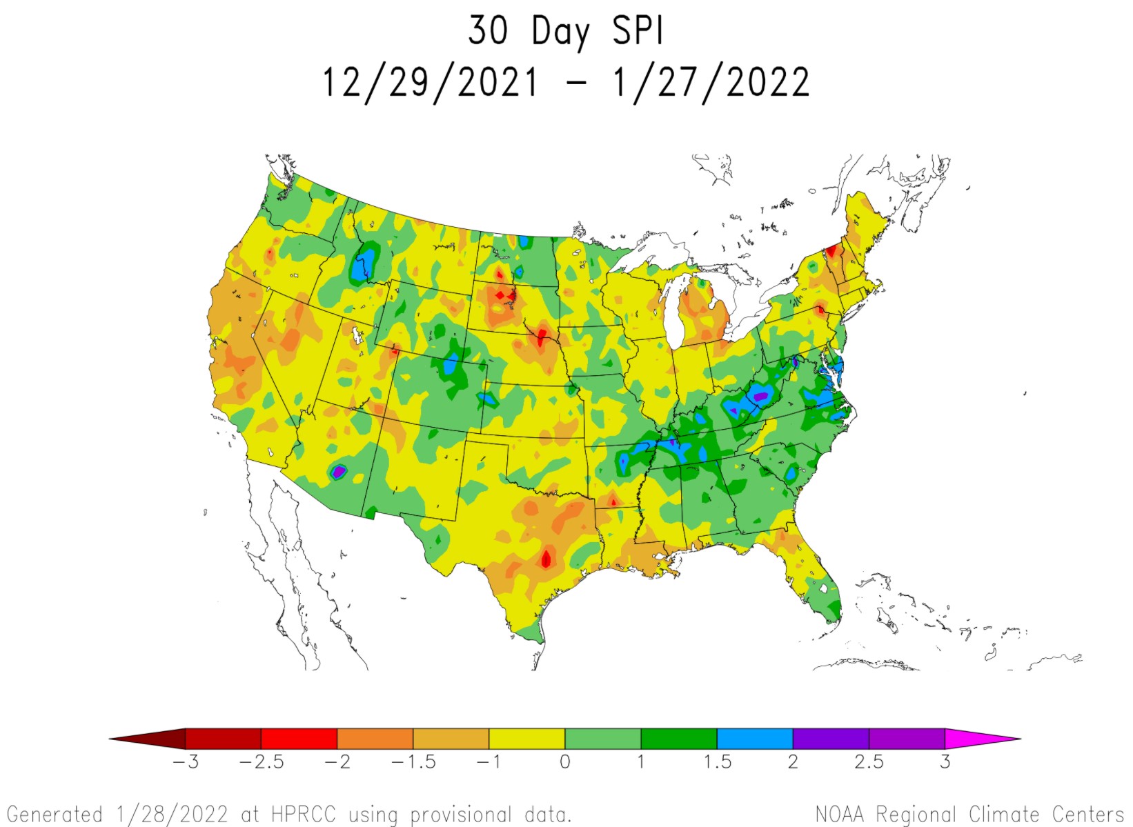
While the snow is great and all, it’s the melted water that truly matters for helping to turn the tide on the drought that has been raging across the area since late summer. Boulder has received 1.56″ of precipitation so far in January which is more than three-quarters of an inch above normal. The map below shows the Standardized Precipitation Index (SPI) for the last 30 days. SPI is used to compare precipitation as it relates to “average” over regions with vastly different climates. North-central Colorado is one of the few “bright” spots across the West to start 2022.
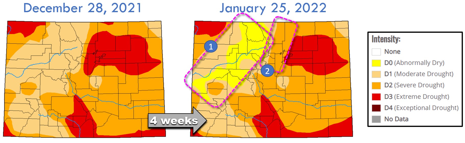
Just over the last month or so we’ve seen subtle improvements to the drought situation across the state in response to the uptick in winter weather events. There were two clear areas of improvement:
- The Mountains saw several waves of heavy snow from mid-December into mid-January, including a plethora of snow associated with a major atmospheric river event around the Holidays
- The Front Range, particularly the western Denver Metro area and Foothills, have been on the receiving end of as many as 8 minor precipitation events in the New Year
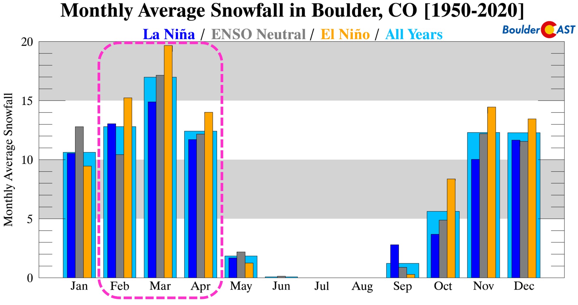
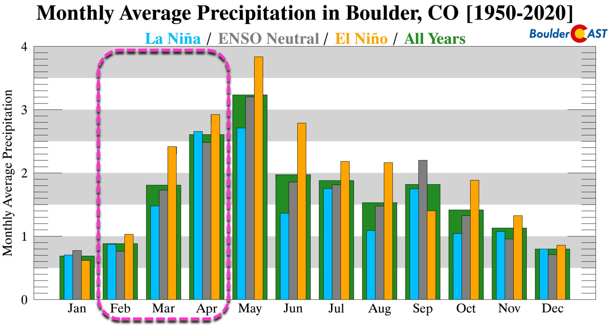
We can’t stress this enough: our region is heading in the right direction, but we’re not there yet. The snowy January is just the start. With La Niña ongoing, we’ve got an uphill battle ahead of us as our area tends to see less snow (and less moisture) during the late winter and spring under La Niña. For example, in the February to April period during La Niña, Boulder averages ~9″ less snowfall and ~1.3″ less precipitation than during El Niño.
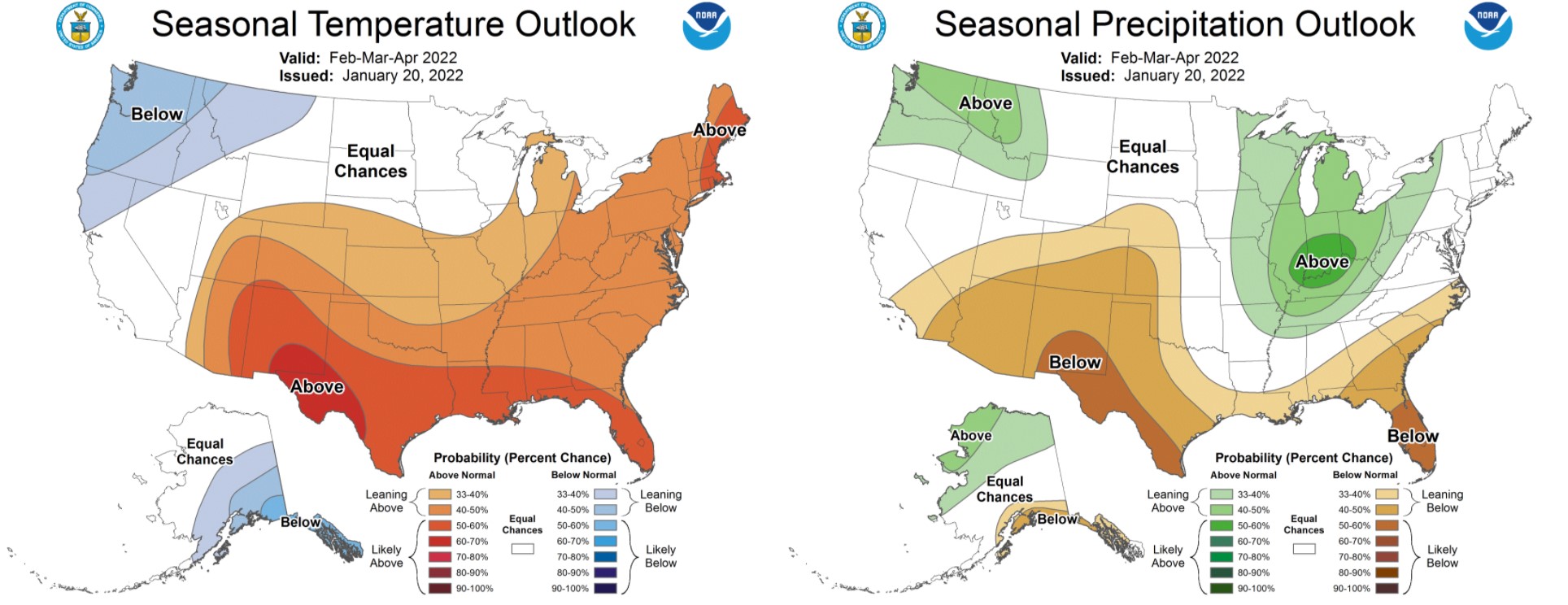
The Climate Prediction Center is leaning towards a drier (and warmer) next three months for almost all of Colorado.
The good news is that we have our three snowiest months ahead which should offer at least a chance at redemption.
La Niña or not, epic drought-busting snowstorms can and do happen over the next few months. You aren’t forgetting what transpired just last March are you? It’s only the end of January and thus time is still on our side to bounce back towards a “normal” snow season — something that seemed damn near impossible just a few short weeks ago. Mother Nature has thankfully given us a fighting chance…
Get BoulderCAST updates delivered to your inbox:
We discuss Boulder and Denver weather every single day on BoulderCAST Premium. Sign up today to get access to our daily forecast discussions every morning, complete six-day skiing and hiking forecasts powered by machine learning, access to all our Front Range specific weather models, additional storm updates and much more!

Enjoy our content? Give it a share!


You must be logged in to post a comment.