The Arctic air has arrived in the Front Range and it’s here to stay for several more days. We take a quick look at the overnight snow totals, the record low temperatures set already Saturday morning, and update you on the forecast for the rest of the weekend. More accumulating snow and even colder temperatures are on the way!
Welcome to the Arctic!
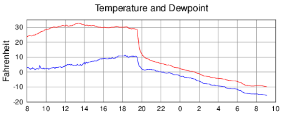
The Arctic cold front blew through Friday evening right on schedule around 7:45PM in Boulder and shortly thereafter in Denver. It was actually one of the slower moving and overall less impressive Arctic fronts in recent memory, but the temperature change with the front was certainly no slouch!
7:20PM: Longmont, Erie, Brighton have gone cold. DIA, Broomfield and Boulder up next.
Side note: Perhaps one of the slower moving Arctic fronts in recent memory… #COwx pic.twitter.com/ElDnbniOVT
— BoulderCAST Weather 🏔️❄️ (@BoulderCAST) January 13, 2024
At our station, we reported a temperature drop of 23°F (31° -> 8°F) in the first hour, with temperatures continuing to nosedive throughout the rest of the night, bottoming out at -11°F at around sunrise Saturday. This frontal passage was far less impressive than the record-obliterating, dust-storm inducing major Arctic blast we had back in December 2022.
A very fine, light snow began within minutes following the front in Boulder, with a few bands of more moderate snowfall passing through during the wee morning hours as expected.
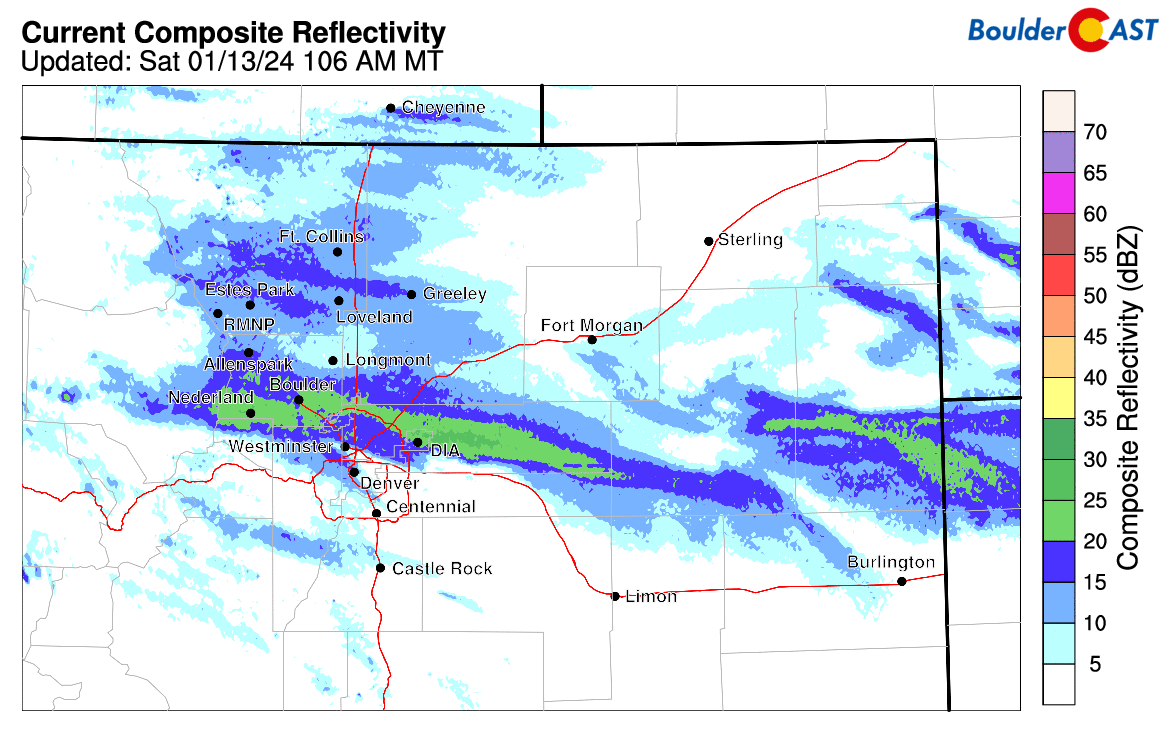
Radar loop from the early morning hours on Saturday when a few embedded moderate bands of snow were around
Overall, a broad brush of a dusting to 4″ of snow fell across the entire Denver Metro area, roughly in-line with forecast expectations. Up to 19″ of snow fell just a handful of miles west in the Mountains above 10,000 feet! Shown below is our snowfall forecast map issued Thursday evening with actual storm totals overlaid. Green values indicate that our forecast verified to within one inch of the observed snowfall total. Red numbers did not.
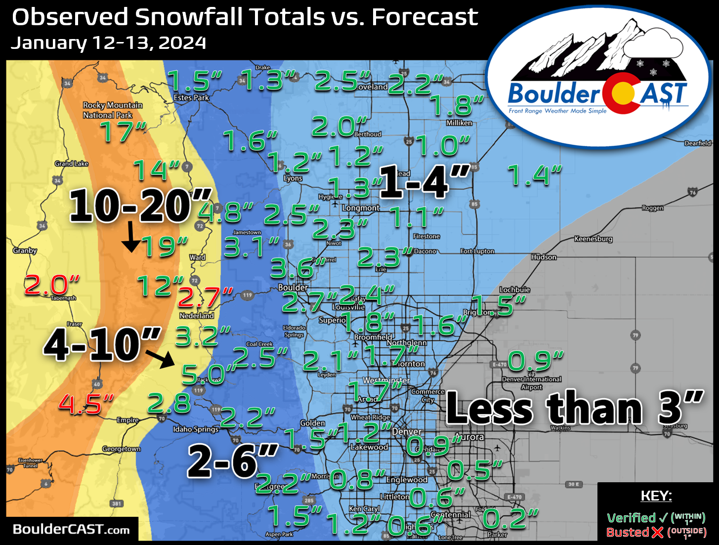
Outside of the big peaks, snow totals were highest around the Boulder area with 2-4″ here. Officially 2.7″ of snow fell in Boulder (final amount may increase slightly) with 0.9″ in Denver.
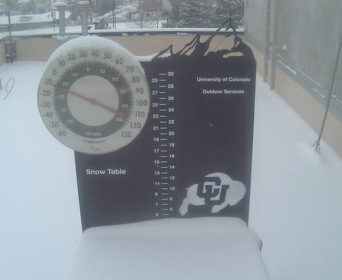
CU Boulder snow table at 8AM Saturday, about 3.5″ of snow
The snow might look like fun to play in this morning, but the brutally cold wind chills say otherwise. Just about everyone will be walking out into dangerous wind chills in the -20s! Bundle up if you plan to head out and about for any reason today!
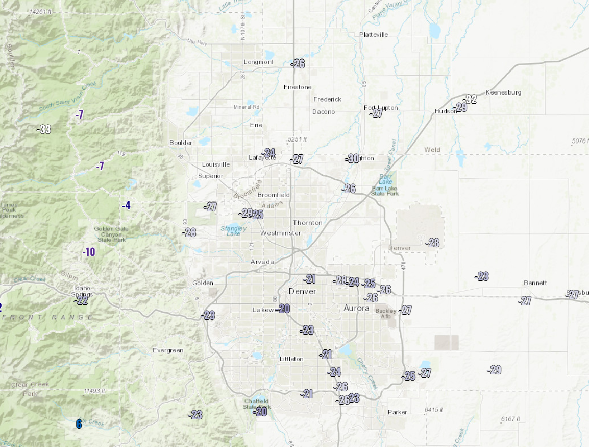
Bone-chilling wind chill readings from around 8AM Saturday
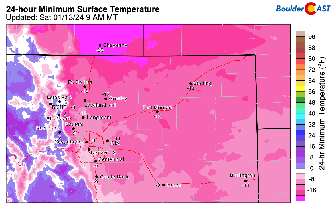
Not even factoring in the wind, our actual temperatures Saturday morning bottomed out mostly in the negative teens across northeast Colorado. We’ve already confirmed that a new record low temperature was set in Denver which hit -12°F — the prior record was -11°F from 1875. Boulder likely also at least tied its record (-12°F from 1997), but we haven’t received an official report as of yet.
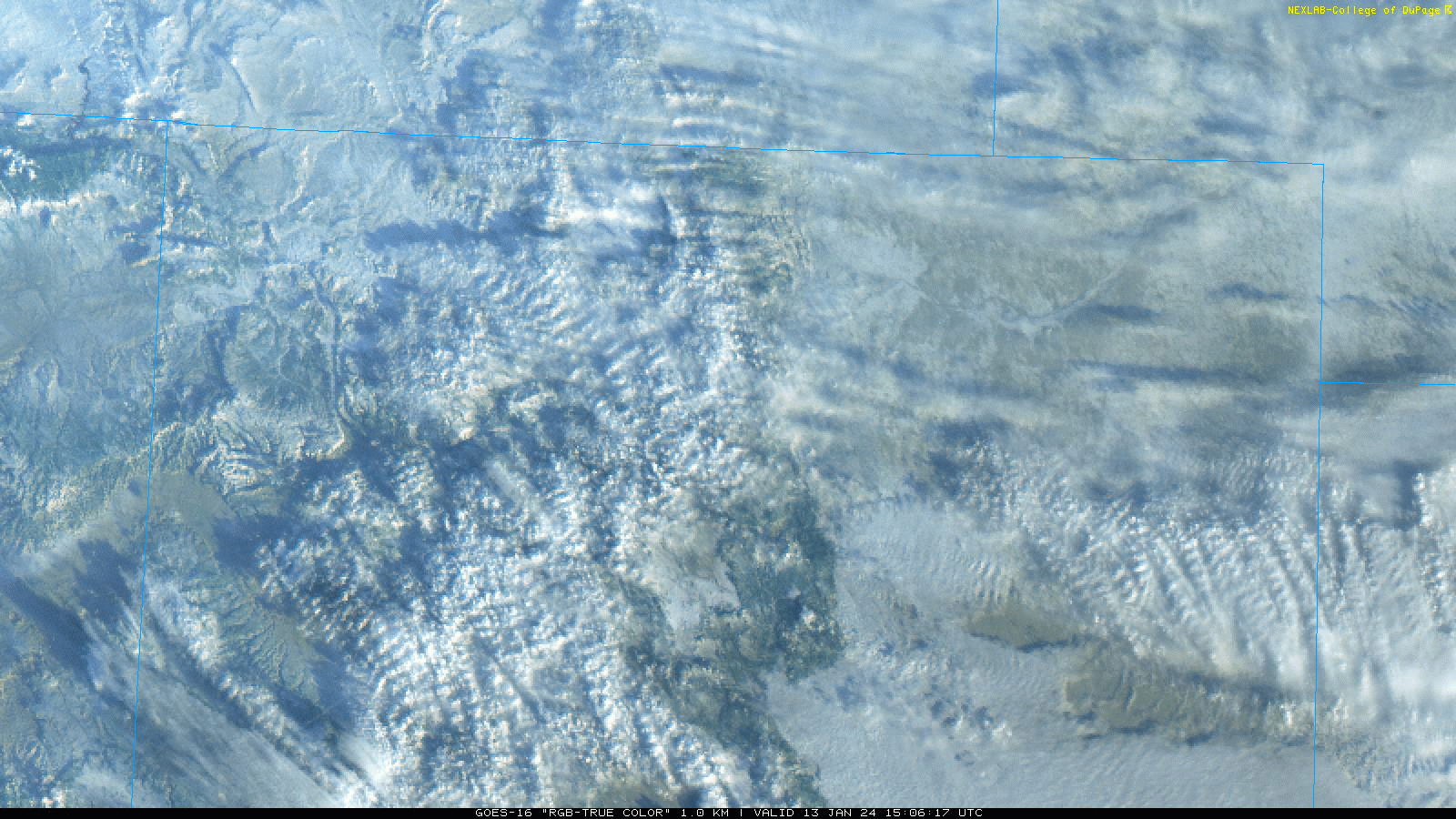
Skies are already clearing out across the region as seen from GOES-East. We can tell from the satellite imagery that just about everyone got snowed on overnight, though it appears mostly light across eastern Colorado with the dormant prairie vegetation still largely in view.
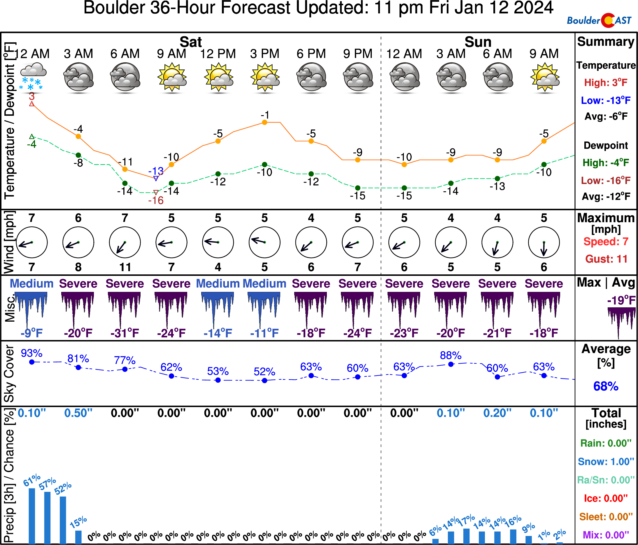
There will be a mix of clouds and sunshine through the day, but temperatures won’t be warming up much. In fact, our NowCAST blended product is showing a high of only -1°F today in Boulder with wind chills never getting above -10°F!
Not surprisingly, it will be much nicer in Boulder than on top of Longs Peak, where wind chills will be colder than -50°F on Saturday! Of course, even -50°F wind chills are nothing compared to the -110°F wind chills felt in my time spent in Greenland during polar winter!
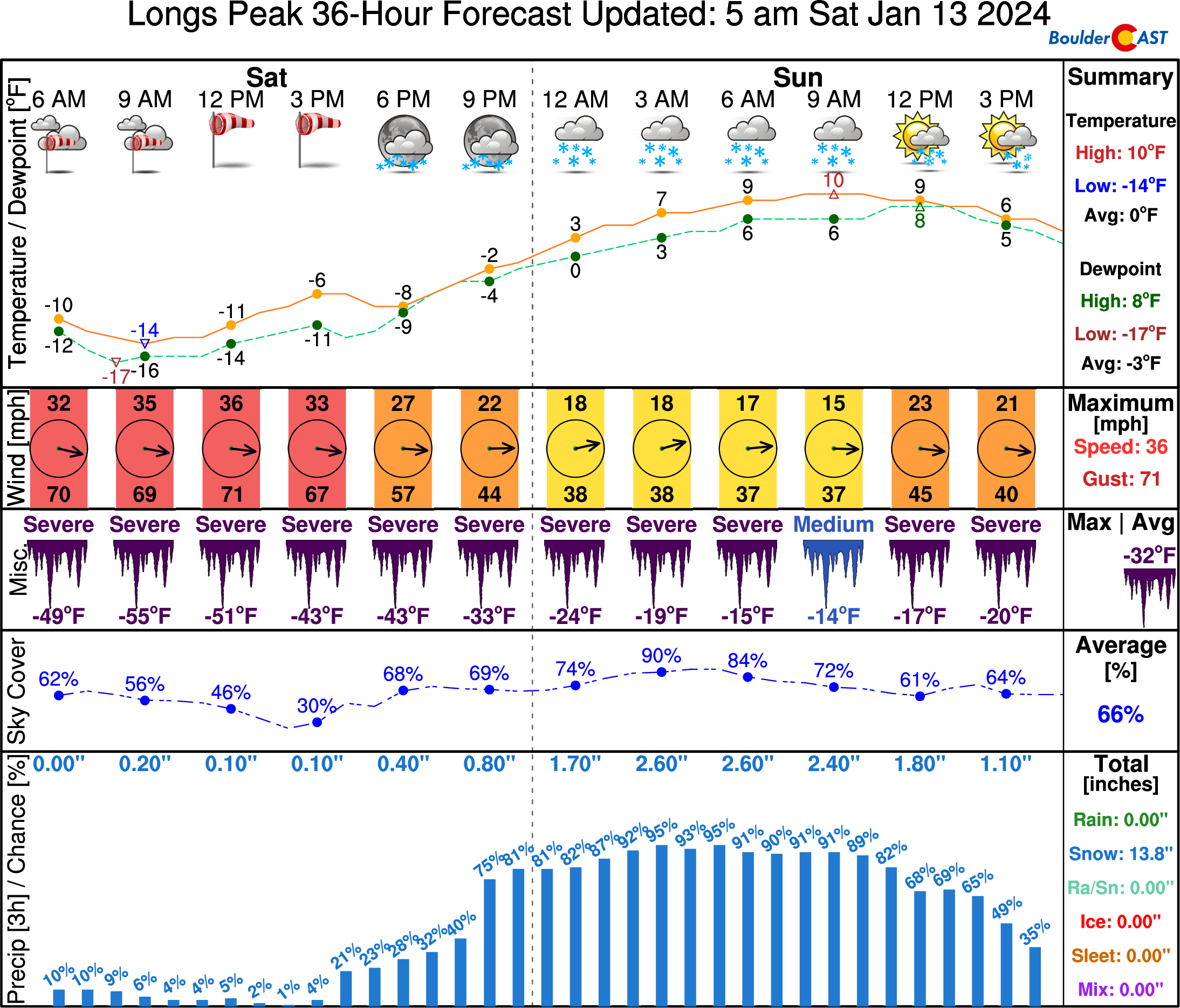
Fun Fact: The 14,000-foot summit of Longs Peak will actually be about 20 degrees warmer than Boulder tonight into Sunday as warm and moist flow from the Pacific Ocean races into Colorado from the west! However, this flow will create heavy snow in the Mountains with 1 to 2 feet of new powder expected up on top of Longs Peak by Sunday evening. Because of this, we don’t recommend climbing your way up there to escape the bitter cold in the Metro area!
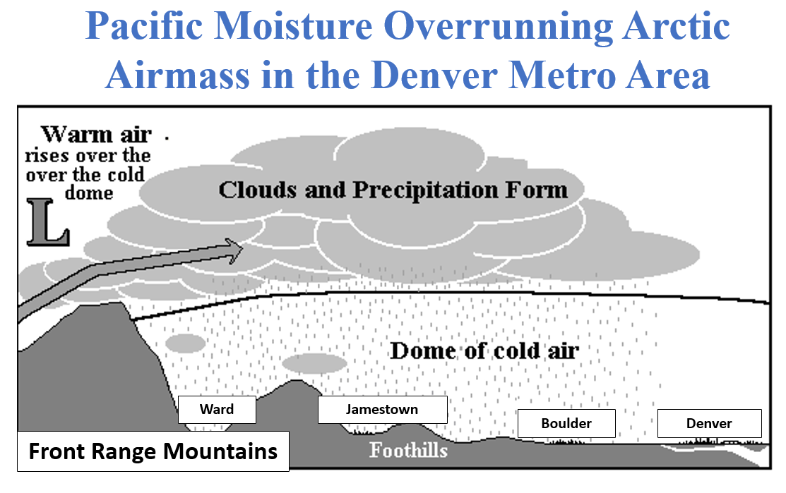
This influx of moisture from the west will lead to another overrunning snowfall event Saturday night through Sunday with heavy snow widespread across much of the Mountains with snow amounts measured in feet, not inches. Light to moderate snowfall will then continue in the Mountains through Monday and into Tuesday. The dome of Arctic air east of the Mountains will help extend some of this snowfall into the Foothills and adjacent Plains at times as well.
Shown below is our snowfall forecast map covering all snow through the rest of this Arctic outbreak, basically between Saturday afternoon and Tuesday evening.
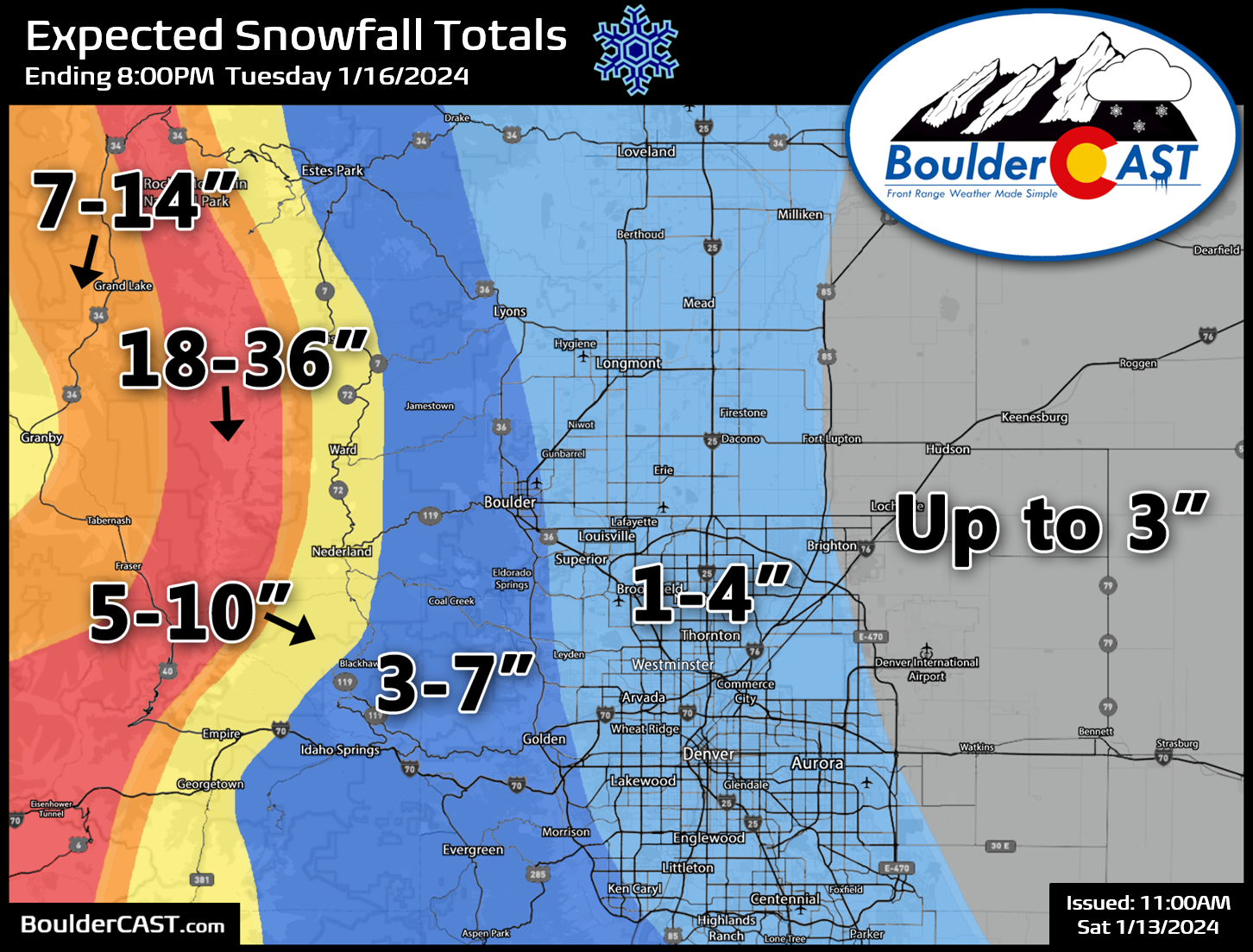
While snowfall will be fairly continuous in the Mountains the next few days, there will be two specific waves across the lower elevations to watch out for:
- Light overrunning will be possible late Saturday night into Sunday with up to 1″ of accumulation around Boulder, and just a dusting or less in Denver. 3-6″ may fall in the highest Foothills along Peak-to-Peak Highway.
- A second more widespread wave of snow will spread into the Metro area during the day Monday, perturbed by a combination of upslope and jet-forcing. This wave will produce a broad area of light snow in Boulder and Denver, but with the risk of embedded heavier bands. This should produce 1-4″ in the Denver area and another 2-5″ around Boulder.
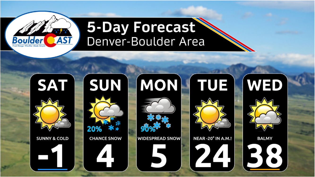
For now, here’s our current expectations for the rest of the Arctic outbreak below. Pay very close attention to Monday night!
- Saturday: Light morning snow will quickly taper off. Partly sunny and bitter cold with highs around 0 degrees.
- Saturday night: Temperatures drop to -10 to -15° in the Metro area, again setting record low temperatures.
- Sunday: A heatwave ensues with temperatures pushing into the positive single digits for highs.
- Sunday night: Temperatures may actually increase overnight ahead of a secondary cold front. Lows within a few degrees of zero either way.
- Monday: As secondary surge of even colder Arctic air pushes in from the north during the day with temperatures falling from the single digits to below zero as the day progresses. Widespread snow is expected during the morning and afternoon, heavy at times. 1-3″ in Denver, 2-5″ in Boulder.
- Monday night: Snow ends quickly in the evening with skies clearing out overnight. Temperatures will drop like a rock to their coldest levels of the entire event, maybe even the coldest since 1990! Right now we are expecting overnight lows to range from -12°F to -22°F. Some outlying areas may drop as low as -30°F!
- Tuesday: After the record-obliterating morning low, we should warm up into the 20s during the day with lots of sunshine. The warming trend will continue the rest of the week!
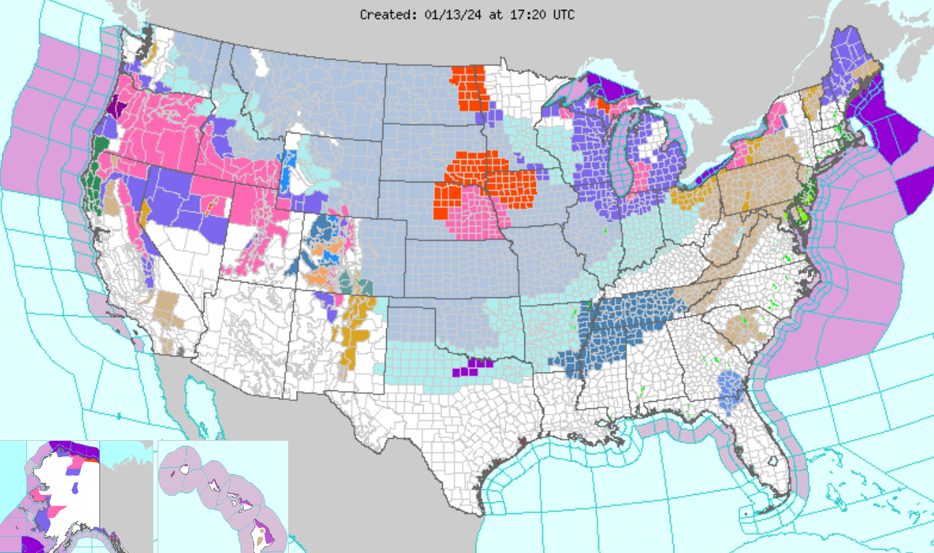
This ongoing Arctic blast is not just a Colorado problem this weekend. It is literally impacting the entire nation right now. We’ve got blizzard conditions in seven states, dangerous wind chills all the way south into Dallas, accumulating snow expected in the Gulf Coast states, and freezing temperatures in parts of Florida. Several NFL playoff games are being impacted as well, including extremely dangerous wind chills in Kansas City for the Chiefs vs. Dolphins game, and the Steelers vs. Bills game in Buffalo which already got postponed due to feet of lake effect snow. Only Arizona is dodging the outlandish weather this week it seems, at least according to the National Weather Service’s active highlights map:
Well, now it’s time for me to head out and do some shoveling while the sun is shining. Check back late Sunday or Monday morning for our usual weekly outlook. We’ll provide some final details on the widespread snow expected Monday and an update on just how badly we will shatter the existing record low Monday night! Also, be sure to follow us on Twitter, Threads, or Facebook for real-time updates in the days ahead, or join us on BoulderCAST Premium for in-depth daily updates every morning. Have a great rest of the holiday weekend, stay warm, and enjoy the snow!
Get BoulderCAST updates delivered to your inbox:

Go Premium, get all the perks.
Daily Forecast Updates
Get our daily forecast discussion every morning delivered to your inbox.
All Our Model Data
Access to all our Colorado-centric high-resolution weather model graphics. Seriously — every one!
Ski & Hiking Forecasts
6-day forecasts for all the Colorado ski resorts, plus more than 120 hiking trails, including every 14er.
Smoke Forecasts
Wildfire smoke concentration predictions up to 72 hours into the future.
Exclusive Content
Weekend outlooks every Thursday, bonus storm updates, historical data and much more!
No Advertisements
Enjoy ad-free viewing on the entire site.
Enjoy our content? Help us out and give it a share:


You must be logged in to post a comment.