


A broad, slow‑moving heat dome has settled over the West, delivering a run of persistent October warmth to the Front Range — but this quiet, summerlike stretch won’t hold forever. This week will be defined by record‑challenging heat aided by downslope flow, and only the faintest chances for a few stray rain showers before a major pattern shake‑up arrives early next week. Ensemble guidance hints at everything from long‑awaited rainfall to the season’s first frost, with even a few early‑season snow scenarios lurking in the spread. Read on for all the details.
This week’s highlights include:
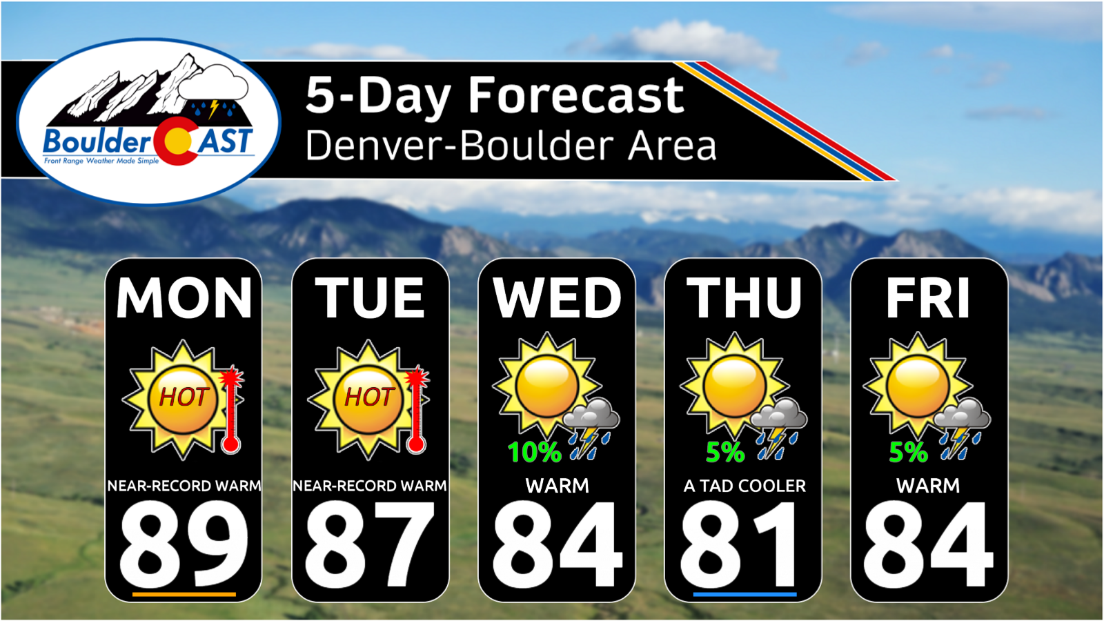
- 🔥 Stubborn Western ridge keeps the Front Range warm all week, locking in 80-degree temperatures with little day to day change in the weather expected.
- 🌡️ Heat dome longevity is the headline, with another week of above‑normal temps before a trough finally breaks it down next week.
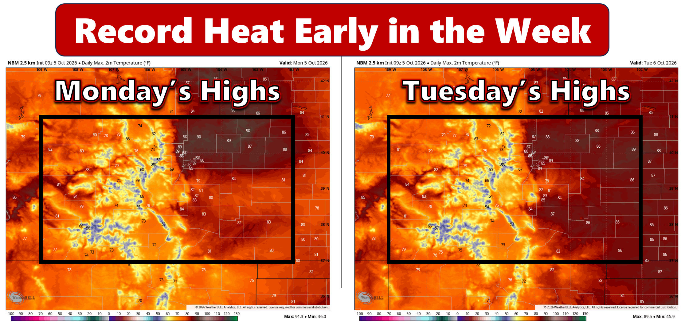
- 🌬️ Downslope warming will help push Denver and Boulder toward record territory Monday and Tuesday.
- 📈 Record highs in play, as Boulder approaches its all-time October record high and latest 90° day. Denver could break two daily records.
- ☁️ Weak Tuesday disturbance brings slight cooling, but still leaves both cities within reach of daily record highs.
- 🌄 Low‑end shower chances midweek and beyond, mainly in the Mountains/Foothills; only 5-10% odds of anything drifting into the Metro area.
- ❄️ Major pattern shift possible next week, with ensemble outcomes ranging from continued warmth to measurable rain or even snow.
- 🥶 First frost becomes increasingly plausible early next week, depending on cold air depth and cloud cover; El Niño often delays our first frost, but the growing season is nearing its end regardless.
DISCLAIMER: This weekly outlook forecast is created Monday morning and covers the entire upcoming week. Accuracy will decrease as the week progresses as this post is NOT updated. To receive daily updated forecasts from our team, among many other perks, subscribe to BoulderCAST Premium.

Go Premium, get all the perks.
Daily Forecast Updates
Get our daily forecast discussion every morning delivered to your inbox.
All Our Model Data
Access to all our Colorado-centric high-resolution weather model graphics. Seriously — every one!
Ski & Hiking Forecasts
6-day forecasts for all the Colorado ski resorts, plus more than 120 hiking trails, including every 14er.
Smoke Forecasts
Wildfire smoke concentration predictions up to 72 hours into the future.
Exclusive Content
Weekend outlooks every Thursday, bonus storm updates, historical data and much more!
No Advertisements
Enjoy ad-free viewing on the entire site.
October Heatwave Continues Across the West
After missing out on the major rain event that skirted the Denver Metro late last week, the Front Range has slipped into an exceptionally quiet pattern since Thursday afternoon as broad high pressure settled across the western United States. Temperatures have been locked in the 80s for several days now, and that theme will carry straight through the upcoming week and weekend with very little change expected in the larger‑scale Westwide pattern.
At the heart of this ongoing warm spell is a persistent mid‑level ridge — a heat dome — that has taken up residence across the West. Early Monday, the ridge axis is centered near the Four Corners, but guidance shows it gradually reorganizing farther west toward California as the week progresses.
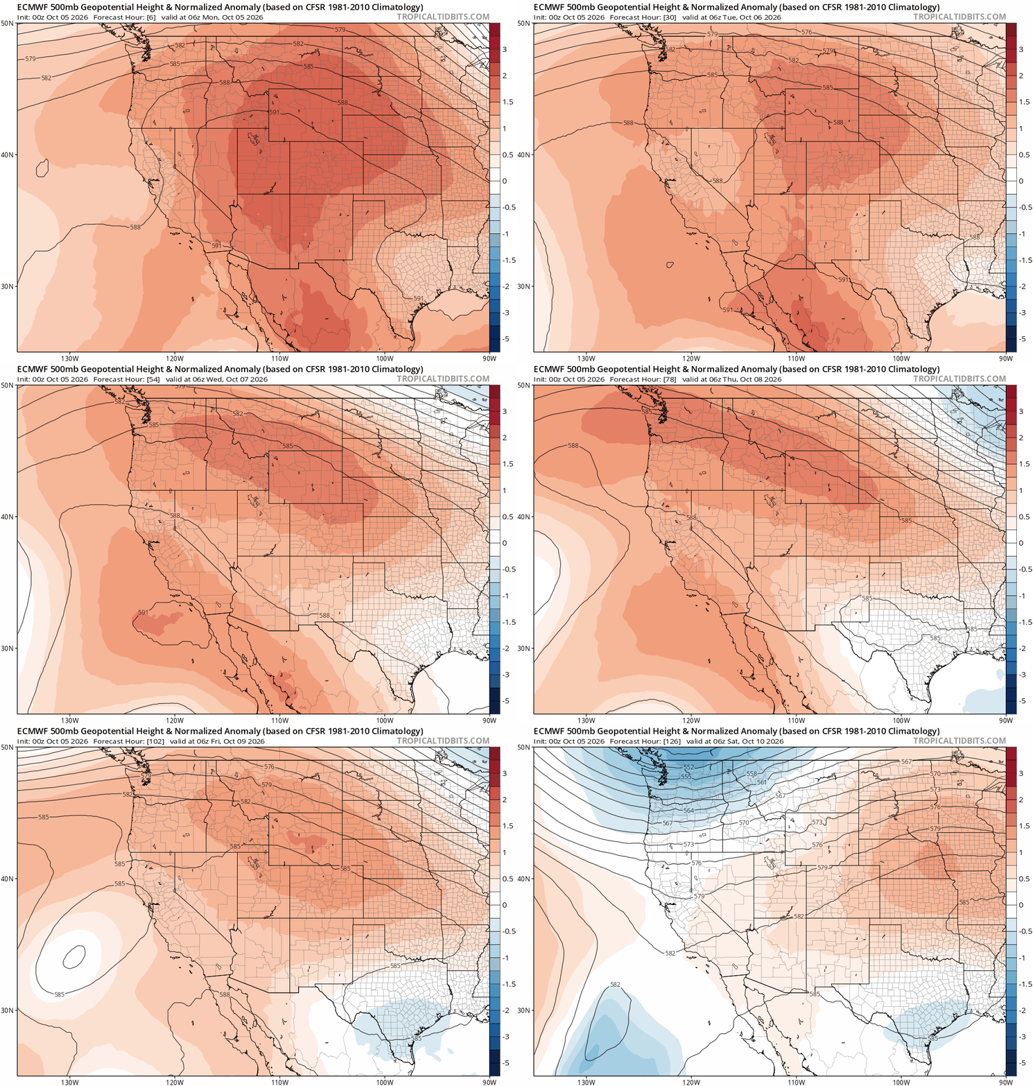
Euro 500mb height anomaly forecast animation through the week showing the persistent Western ridge that will dominate Colorado’s weather.
The ridge isn’t historically strong, but its longevity is the noteworthy part. We’re already four days into this regime, and most ensemble guidance keeps Colorado under its influence for another ~7 days before a meaningful pattern shift arrives sometime early next week.
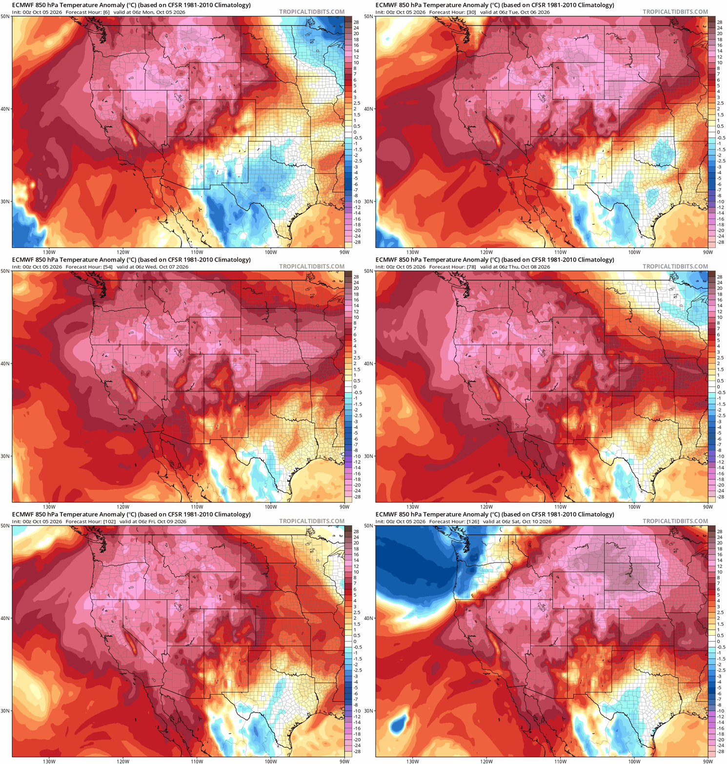
Euro 850mb temperature anomaly forecast animation through the week. The greatest warm anomalies will stay north and west of Colorado, keeping record-obliterating heat largely off the table for us.
While the most anomalous heat will remain displaced to our north and west — focused over the northern Rockies, Great Basin, and California — the Front Range won’t escape unscathed. Temperatures will remain in the 80s throughout the week, with record highs possible Monday and Tuesday as the ridge’s core sits close to Colorado and downslope flow becomes more pronounced.
Downslope Already Showing Its Hand
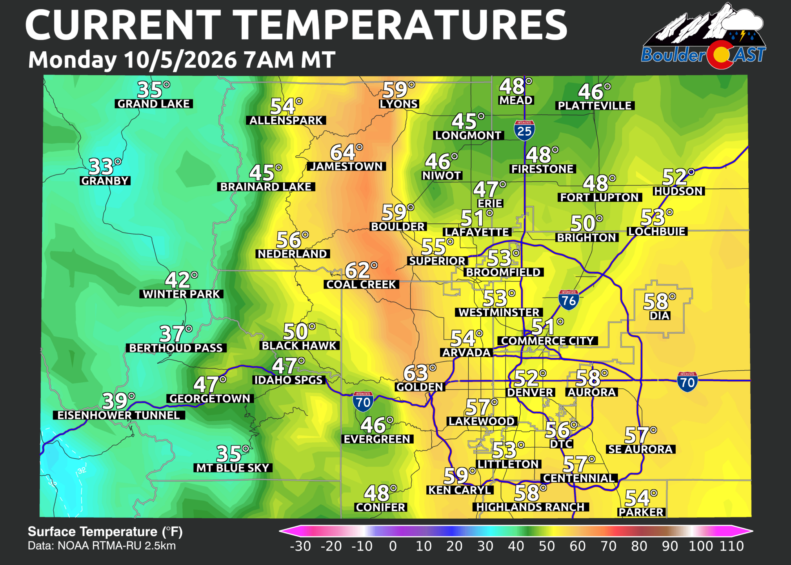
We’re already seeing the classic downslope signature early Monday morning: Foothills‑adjacent neighborhoods are starting the day noticeably warmer than locations farther east. This is a hallmark of weak westerly flow riding over the ridge and descending into the Front Range, warming and drying as it sinks. This downslope flow will be a key player in pushing us to the brink of daily and all-time October record highs the next couple days.
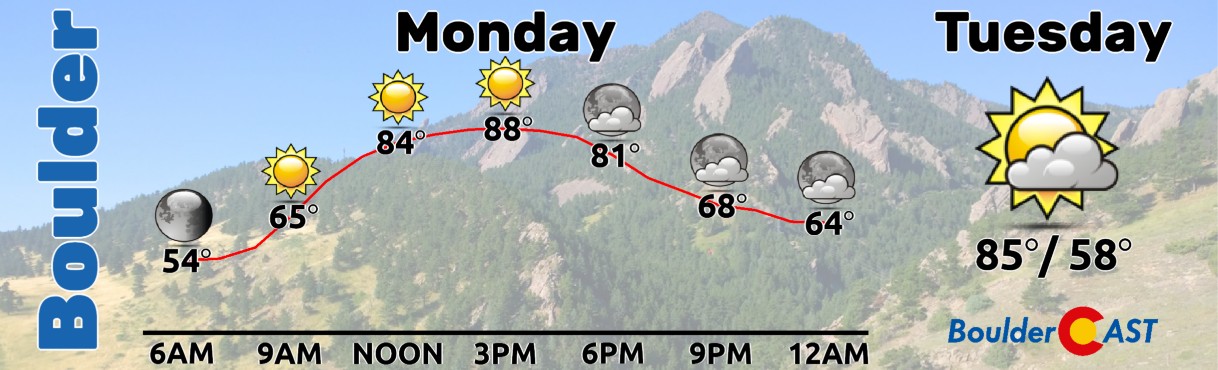
Monday will be mostly sunny with highs surging into the upper 80s. Boulder’s record high for October 5th is 90°F (1947) — which is also the city’s latest 90° day on record and all-time monthly October record high. We’re forecasting just shy of that mark, but it’s close enough to keep an eye on for sure. Denver’s daily record of 87°F (2024) is more attainable and could be tied or broken.
Slight Cooling Tuesday, but Still Near Records
A weak mid‑level disturbance embedded within the ridge will slide across Colorado on Tuesday. This feature brings subtle cooling aloft and a bit more cloud cover, and should trim our temperatures by 1 to 4 degrees compared to Monday. Even so, record highs remain within reach: Boulder’s October 6th record is 86°F (2020) and Denver’s is 87°F (2020). Both are in play.
Mid to Late Week: Small Shower Chances, Still Very Warm
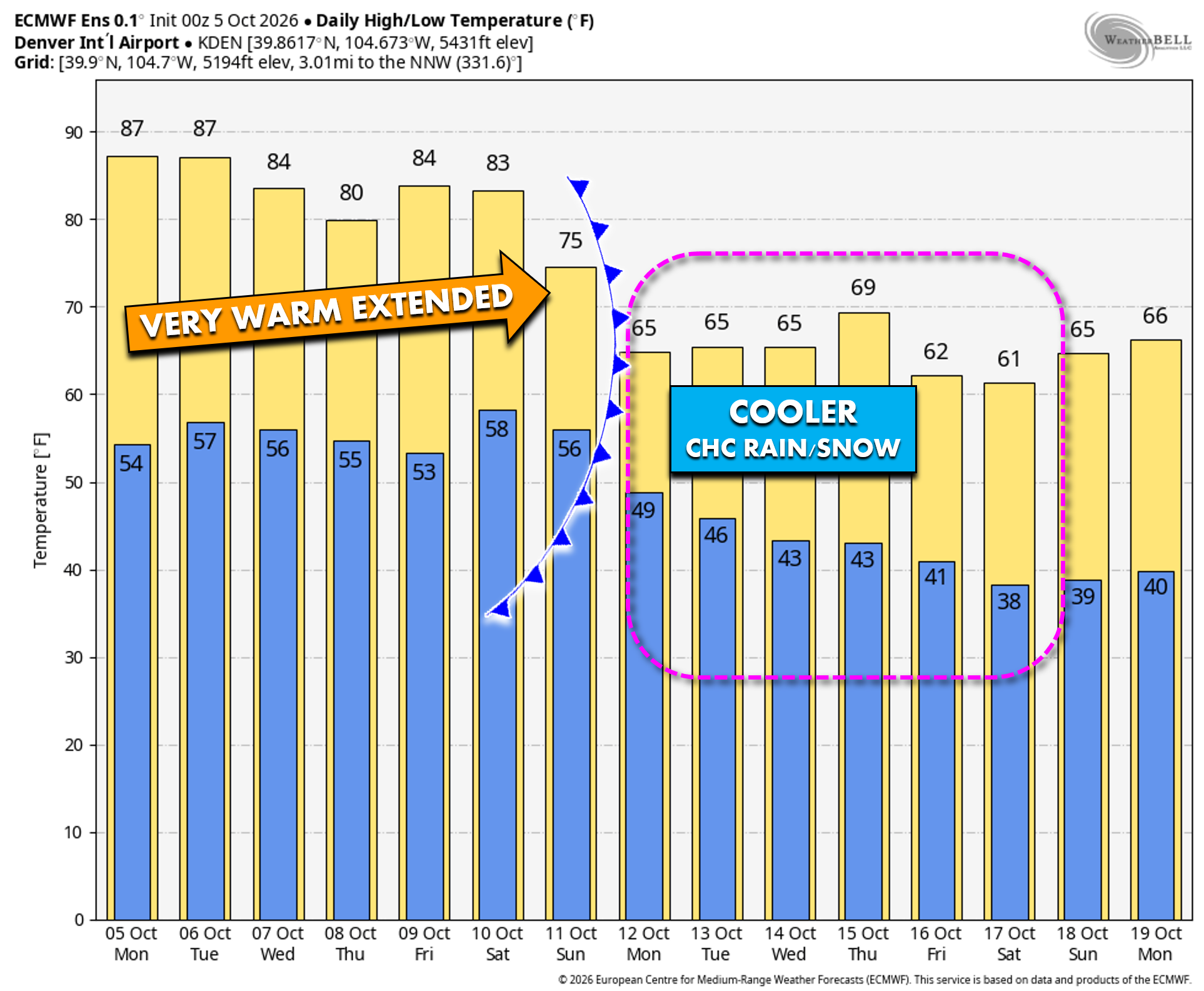
As the ridge’s core shifts westward away from the Four Corners, temperatures Wednesday through Friday should ease slightly into the low and mid‑80s. Each afternoon will feature a small chance (5-10%) of a gusty, terrain‑driven shower or weak thunderstorm in the Mountains and Foothills. A stray shower could drift east into the lower elevations, with Wednesday currently looking like the most favorable day — though still a very low‑end setup. Most of us will remain bone‑dry through the week as the heatwave continues.
When Does the Heatwave End?
The pattern across the West begins to shift this weekend into early next week as the ridge finally breaks down and is replaced by a developing trough. Being a week out, ensemble guidance varies considerably on how this trough evolves and how quickly its impacts reach the Front Range.
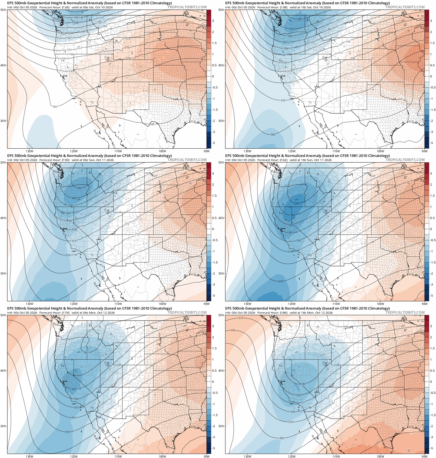
European ensemble mean forecast for 500mb height anomaly during the weekend into early next week showing the expected trough that will develop over the West.
Saturday still looks warm — highs in the 80s under mostly sunny skies. Cooler air tied to the trough could arrive as early as Sunday, though several ensemble clusters delay the push until Monday or Tuesday as the trough digs south and potentially stalls over the Great Basin. That slower scenario currently appears more likely, but confidence is low.
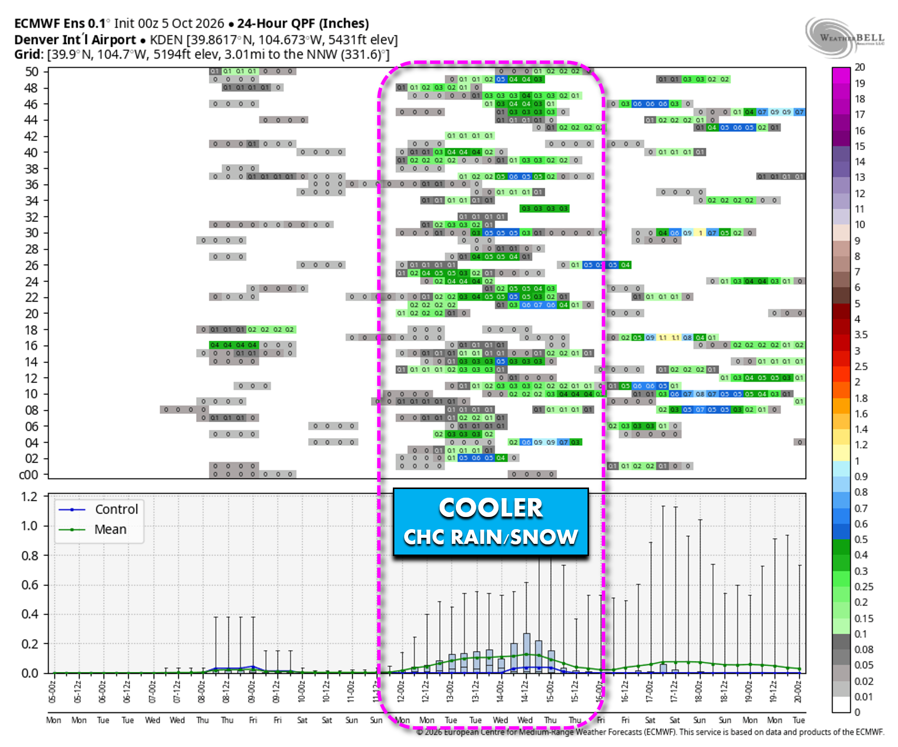
From Sunday onward, ensemble spread ramps up dramatically. Solutions range from continued summerlike warmth to accumulating snow and/or frost in the Denver area. Some members — including the latest ECMWF run — even pull the remnants of Hurricane Rachel towards Colorado early next week.
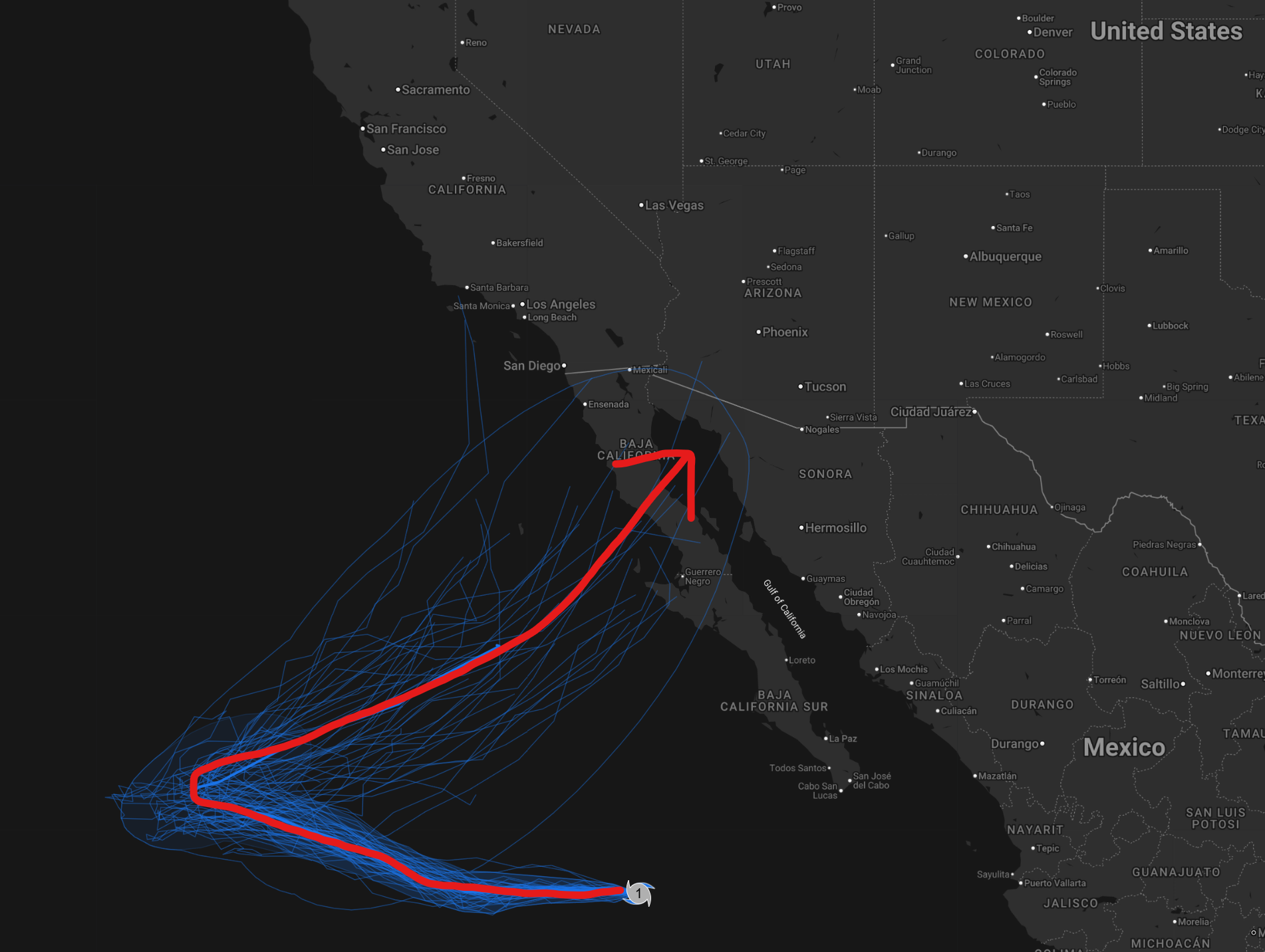
Hurricane Rachel ensemble track forecast over the next 7 days. A sharp recurve of the remnants is expected to bring it back towards the Baja this weekend.
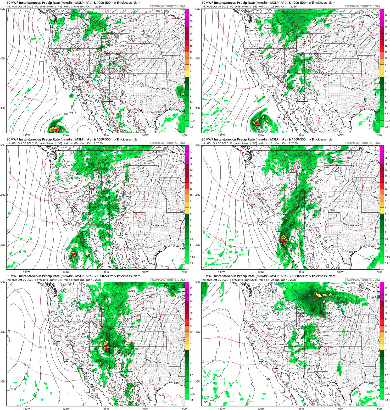
Latest Euro model showing Rachel’s remnants becoming a major player in the West early next week as it gets absorbed into the trough. This outcome remains HIGHLY uncertain and this is just an example.
While the potential for precipitation, and especially snow, remains highly uncertain here, at minimum we will see the end of the heatwave, with temperatures falling back towards or, more likely, below normal by Monday or Tuesday.
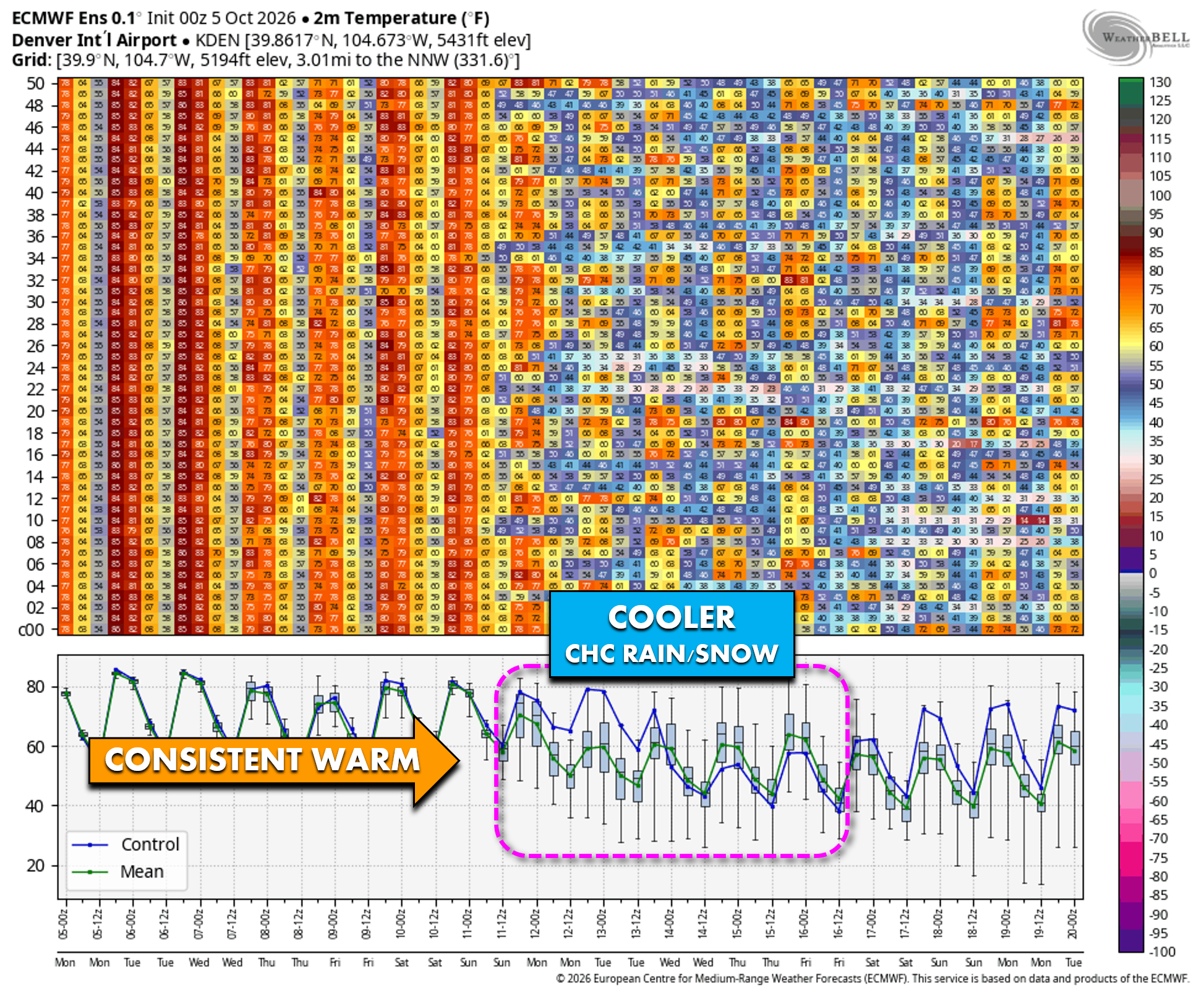
About 80% of European ensemble members show measurable precipitation in the Boulder–Denver corridor early next week, while ~15% depict measurable snow. That’s a wide spread, but it’s enough to at least pique our interest heading into the middle of the month.
First Frost? Not Guaranteed, But Increasingly Plausible
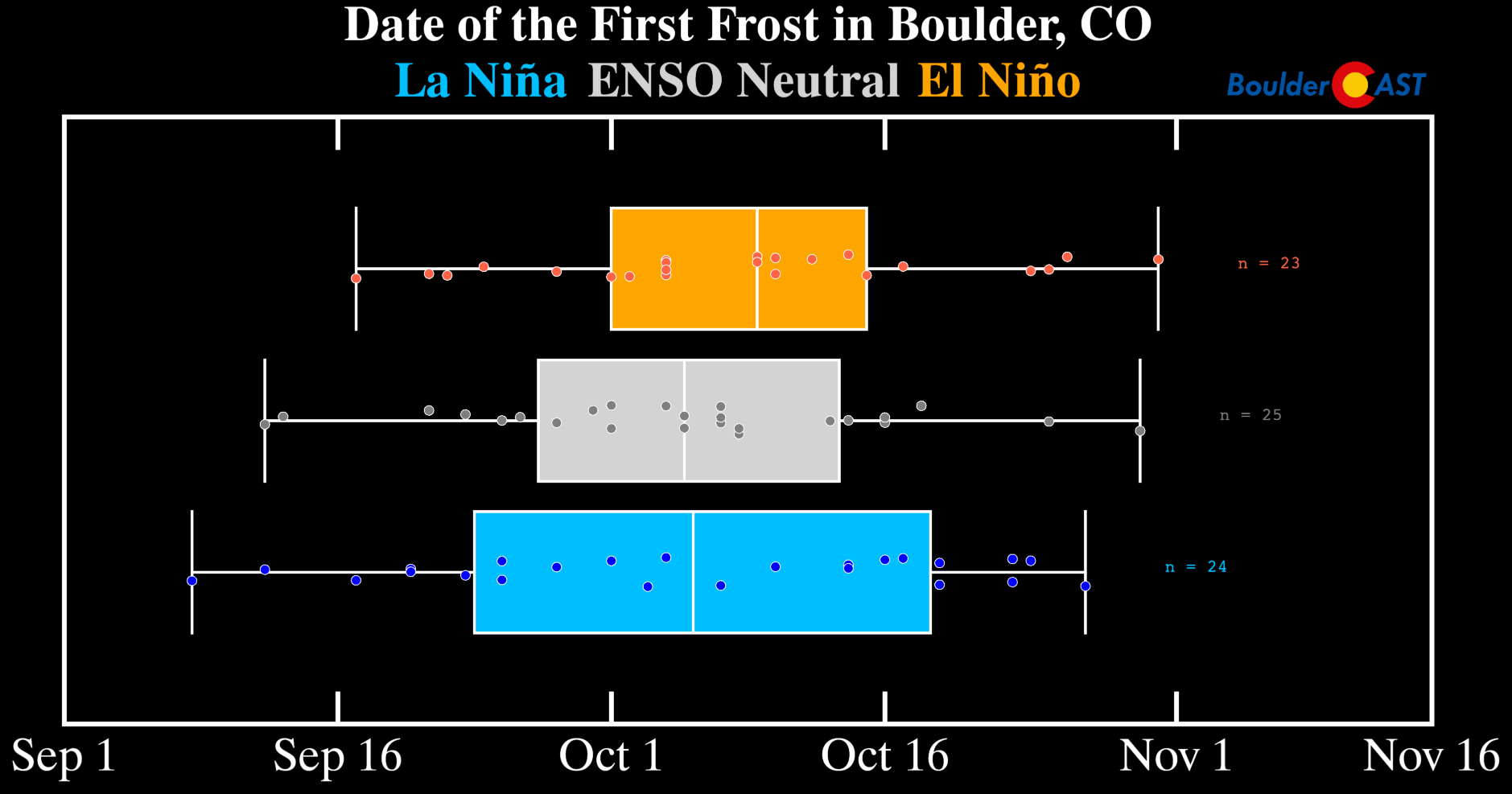
The first frost of the season could occur next week depending on the magnitude of the cold air, cloud cover, and precipitation. It’s far from a sure thing — but this time of year, it doesn’t take much. Given the longer nights, even slightly cooler‑than‑normal patterns can produce frost under clear skies. El Niño autumns, like the one we’re in now, tend to delay the first frost by about a week, but the end of the growing season for sensitive plants is approaching rapidly regardless.
That’s all for now. Try to take advantage of this week’s beautiful weather as it won’t last forever. Have a glorious week!
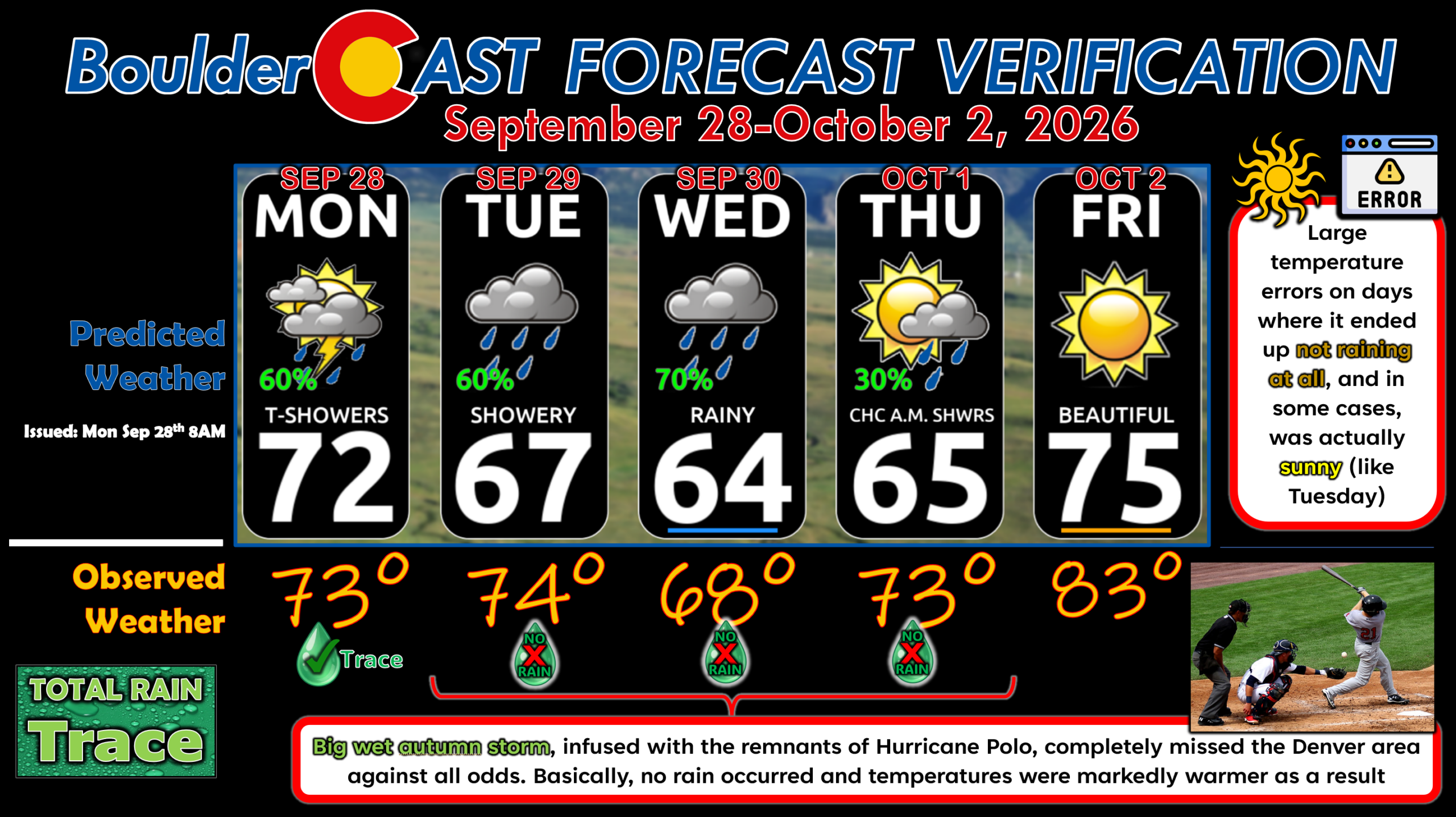
Forecast Verification: September 28-October 2, 2026 (Last Week)
- 😑 Wet storm totally whiffed the Denver area, but supplied most of southern Colorado with beneficial rains (up to 6″ in some cases).
- 🌵 Trace of precip only in Boulder, 0.01″ in Denver.
- 👎 Large 7°+ temperature errors on 3 days
DISCLAIMER: This weekly outlook forecast is created Monday morning and covers the entire upcoming week. Accuracy will decrease as the week progresses as this post is NOT updated. To receive daily updated forecasts from our team, among many other perks, subscribe to BoulderCAST Premium.
Go Premium, get all the perks.
Daily Forecast Updates
Get our daily forecast discussion every morning delivered to your inbox.
All Our Model Data
Access to all our Colorado-centric high-resolution weather model graphics. Seriously — every one!
Ski & Hiking Forecasts
6-day forecasts for all the Colorado ski resorts, plus more than 120 hiking trails, including every 14er.
Smoke Forecasts
Wildfire smoke concentration predictions up to 84 hours into the future.
Exclusive Content
Weekend outlooks every Thursday, bonus storm updates, historical data and much more!
No Advertisements
Enjoy ad-free viewing on the entire site.
Enjoy our content? Give it a share!











Leave a Reply
You must be logged in to post a comment.