
A ridge of high pressure will remain in control of Colorado through the extended and even intensifies this weekend keeping us mostly dry and hot. The best chance of rain in the pipeline comes on Friday, but only limited rainfall is expected from storms due to a lack of moisture. Additionally, the remnants of major Hurricane Hilary in the Eastern Pacific will arrive to the USA this weekend but stay well to the west of Colorado unfortunately (boo!). Things dry out further this weekend into early next week as temperatures once again make a run towards triple digits in the Denver Metro area.
H
ot and mostly dry weather will continue across the Front Range for the foreseeable future as high pressure stays the course over the area. A ridge initially is spread across the entire Rockies today but quickly it consolidates towards Texas by tomorrow becoming a very potent ridge by Sunday. This transition is shown in the GFS 500mb height anomaly forecast animation below. During this time moisture will remain limited for eastern Colorado, though it will be higher than those purely sunny days we had earlier this week.
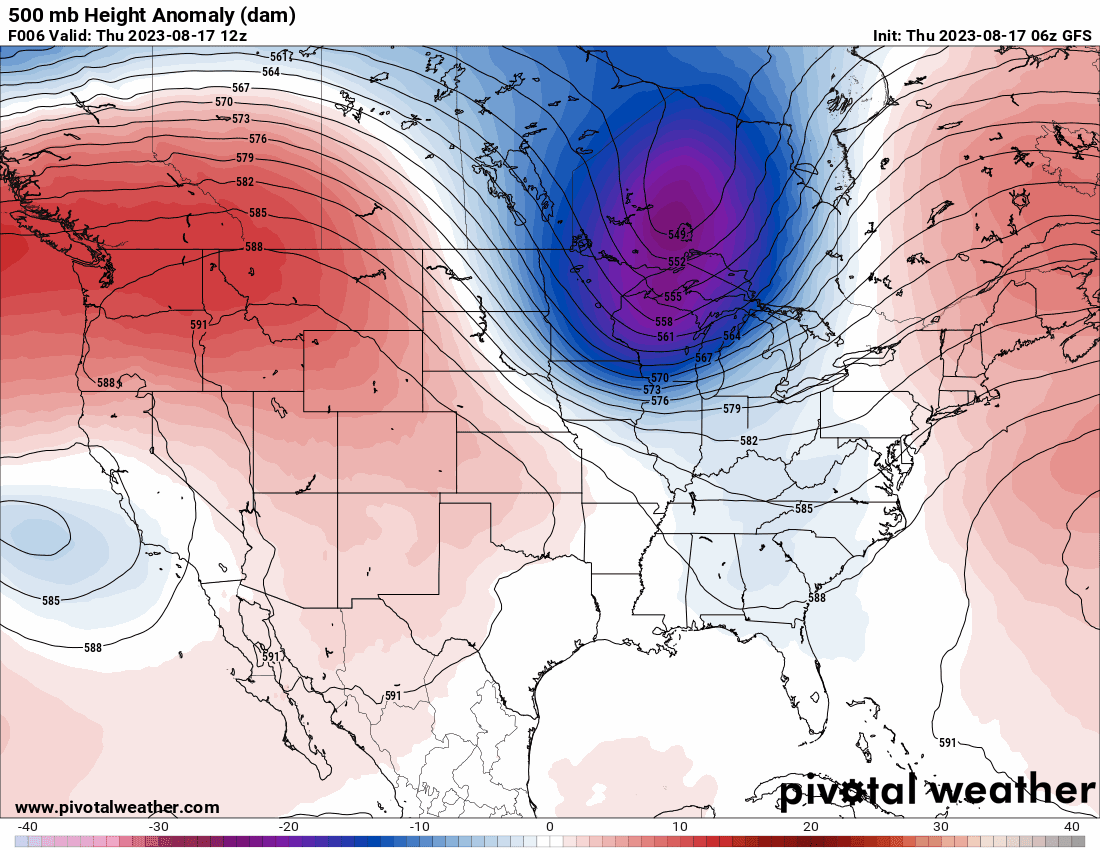
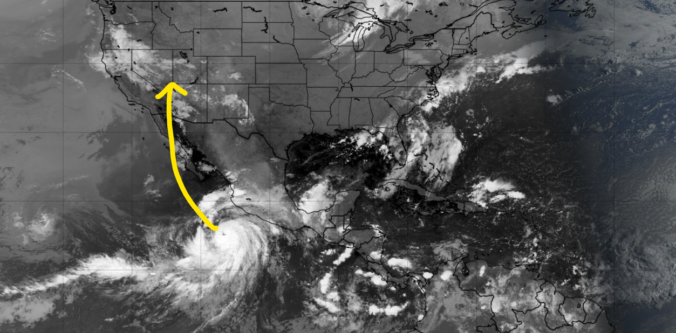
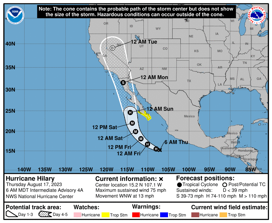
Notice towards the end of the animation the arrival of Hurricane Hilary which is currently forecast to make landfall in Baja California as a weak hurricane or tropical storm Sunday or Monday. It could even make a rare landfall in southern California if the track is just right! The active tropical eastern Pacific is something we warned to keep an eye on earlier in this week’s outlook!
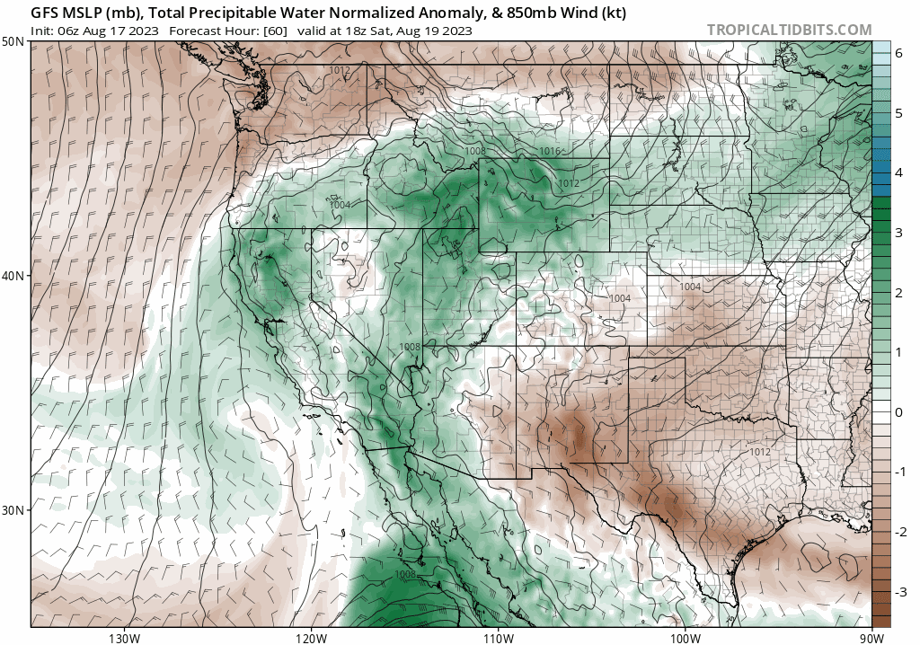
Hirary’s intensity and shear size will draw deep tropical moisture northward into the United States early next week, but with the huge ridge over Texas, all of it will miss Colorado to the west. The GFS moisture anomaly forecast animation below shows Hilary’s soggy impacts. A huge slug of moisture surges northward through California, Nevada and into the Pacific Northwest bringing beneficial rains to areas that have been seeing recent drought.
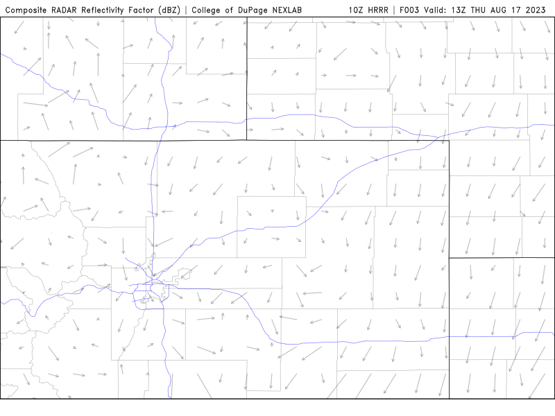
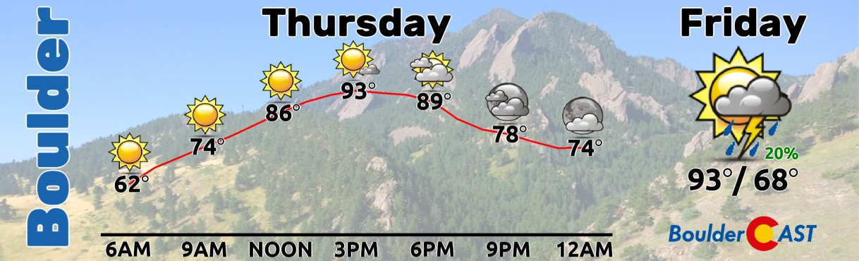
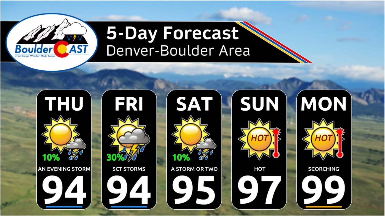
With the tropical discourse now out of the way, things remain quiet here over Colorado today with continued hot temperatures and just a slight chance of a late-day sprinkle or shower coming off the higher terrain for our Thursday. The HRRR model, which has nailed the last few days, shows a slight chance of rain in Boulder from 5 to 8PM this evening with cells entering from the southwest.
The overnight weak cold front did pass as expected just after midnight, so our warm-up will be slower today as a result. However, with mostly sunny skies we will get back into the low to middle 90s by late afternoon, which is eerily similar to yesterday — it’s just a slower jog there. We’re predicting a high of around 93 to 95°F across the Boulder-Denver Metro area today.
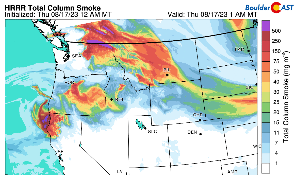
The cold front clipping northeast Colorado this morning also came with a bit of smoke. Did you notice the suspiciously brown sunrise this morning?
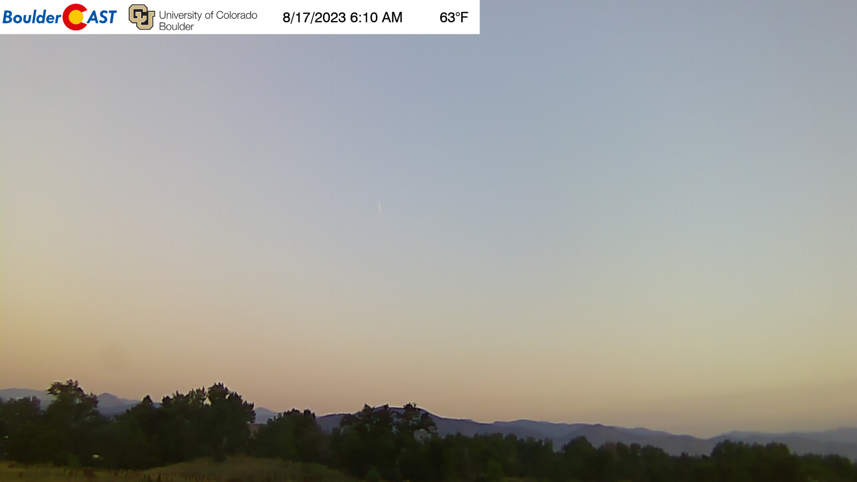
The smoke isn’t too bad at all and it will wash out through the day and head eastward. If you’re curious, this smoke is mostly sourced from large fires burning in the Pacific Northwest, including Montana, Washington, northern California and British Columbia.
A weak pulse of energy and more moisture moves across the Front Range on Friday from the southwest and will produce our best chance of actually seeing rainfall in the extended. Friday will once again rise in the low to middle 90s with more widespread fruitful clouds and storms coming off the terrain. Right now we are expecting about a 20-30% chance of storms on Friday during the afternoon and evening, though rainfall amounts should be light given the limited moisture availability. The ominous storm clouds and subsequent outflows they produce will help to take the edge off the heat at least! Friday was originally planned to be the hottest day of the week, and that still may be true, but it shouldn’t be too much different than the days prior.
As we head into the weekend, the ridge over Texas begins to greatly intensify putting Colorado in a sector of strong warm air advection from the south and southwest. This will lead to significant drying and warming in our extended forecast. You’re not going to like what we have for you in the weather pipeline! Yes Sunday and beyond will dry out completely with temperatures sizzling into the upper 90s!
Monsoon season typically wraps up in the last week or two of August which is rapidly approaching indeed. We’re not going to call the 2023 Monsoon Season dead just yet, but it’s certainly on life support!
Enjoy the weather and stay cool if you can. If it helps, remember that our earliest snowfall on record, which occurred a few years ago in 2020, is just three weeks away! Is it autumn yet?
This weekend outlook is usually only available only to BoulderCAST Premium subscribers. Today’s outlook is available to everyone. Sign up now to gain access to posts like this in the future, our daily weather discussion every morning and much more!

Go Premium, get all the perks.
Daily Forecast Updates
Get our daily forecast discussion every morning delivered to your inbox.
All Our Model Data
Access to all our Colorado-centric high-resolution weather model graphics. Seriously — every one!
Ski & Hiking Forecasts
6-day forecasts for all the Colorado ski resorts, plus more than 120 hiking trails, including every 14er.
Smoke Forecasts
Wildfire smoke concentration predictions up to 72 hours into the future.
Exclusive Content
Weekend outlooks every Thursday, bonus storm updates, historical data and much more!
No Advertisements
Enjoy ad-free viewing on the entire site.


You must be logged in to post a comment.