The week begins on the cooler side, but don’t be fooled! Hot weather, including potential record-breaking heat, is lurking right around the corner as temperatures return to the 90s by Tuesday and stay there the rest of the week. Rainfall will also be hard to come by during this toasty stretch. Let’s take a look at the hot and dry weather week ahead…
This week’s highlights include:
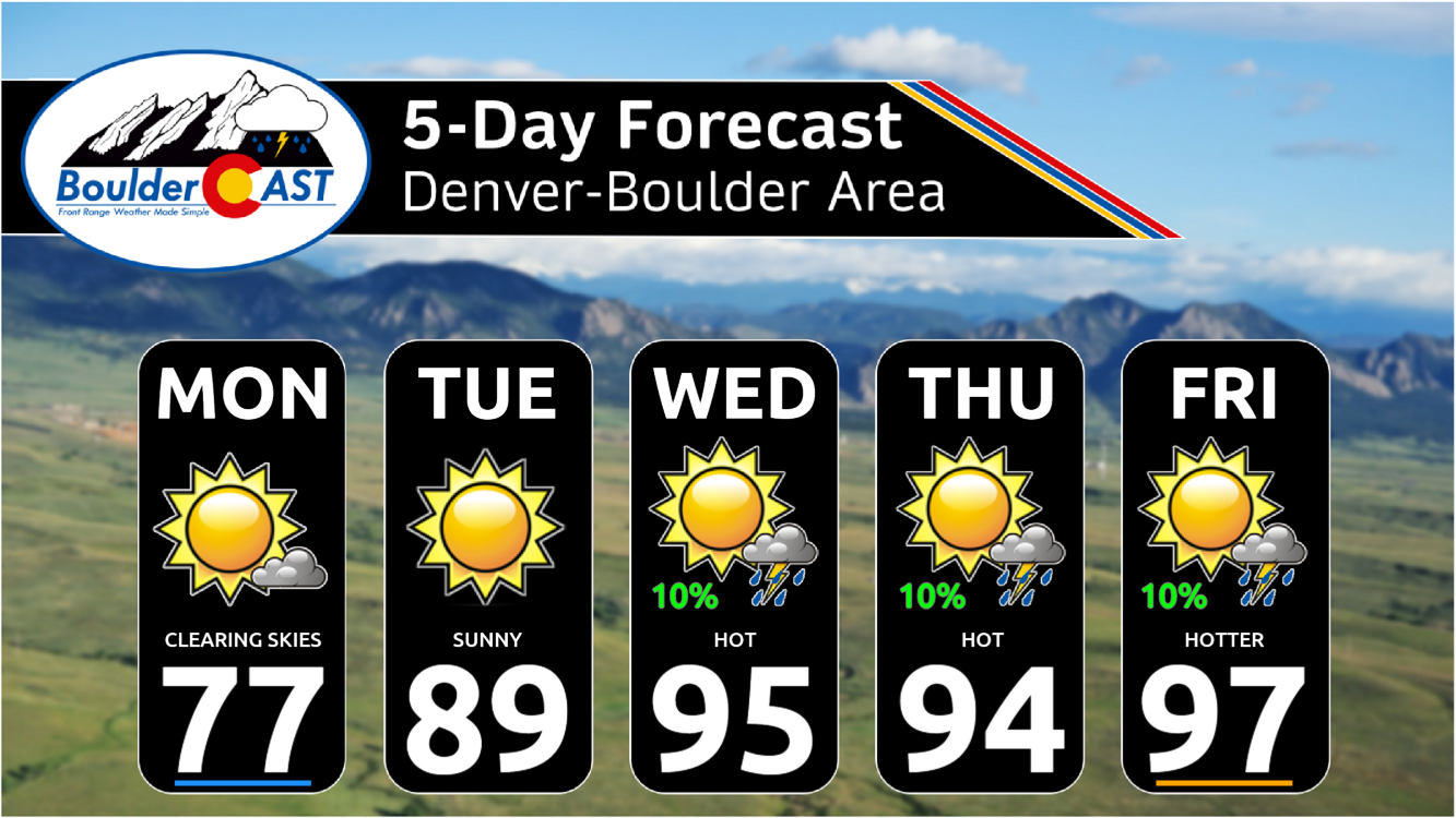
- Cool weather continues on Monday in the 70s as sunshine returns to northeast Colorado
- Heat quickly builds back in on Tuesday with highs getting back to near 90 degrees
- Temperatures stay hot the rest of the week with middle to upper 90s possible — a slight chance to break record highs
- Precipitation remains scant this week across the lower elevations — a better chance exists in the Mountains and Foothills
DISCLAIMER: This weekly outlook forecast is created Monday morning and covers the entire upcoming week. Accuracy will decrease as the week progresses as this post is NOT updated. To receive daily updated forecasts from our team, among many other perks, subscribe to BoulderCAST Premium.

Go Premium, get all the perks.
Daily Forecast Updates
Get our daily forecast discussion every morning delivered to your inbox.
All Our Model Data
Access to all our Colorado-centric high-resolution weather model graphics. Seriously — every one!
Ski & Hiking Forecasts
6-day forecasts for all the Colorado ski resorts, plus more than 120 hiking trails, including every 14er.
Smoke Forecasts
Wildfire smoke concentration predictions up to 72 hours into the future.
Exclusive Content
Weekend outlooks every Thursday, bonus storm updates, historical data and much more!
No Advertisements
Enjoy ad-free viewing on the entire site.
Cool beginnings
Monday will continue the trend of cooler temperatures that got established across the Front Range behind the cold frontal passage early Sunday morning. Sunday was an overall amazing day with overcast skies and temperatures barely reaching 70 degrees during the afternoon. Did you get outside to enjoy the break from the summer heat?
Happy Sunday! The stratus clouds are now solidly locked in until sometime Monday! #cowx #Boulder pic.twitter.com/6IQGml4d5X
— BoulderCAST Weather (@BoulderCAST) August 13, 2023
It won’t be quite as chilly on Monday, mostly because the thick cloud deck will quickly dissipate revealing heaps of sunshine. High temperatures will climb into the upper 70s across the area — still several degrees below normal for mid-August.

No rain is expected on Monday either. Enjoy the pleasant day!

Heat returns Tuesday & beyond
Be sure to take advantage of Monday’s cooler weather as the rest of the week will be a scorcher! The unseasonably cool weather gets ousted quickly by the development of a broad mid-level ridge of high pressure over the Rockies through the week ahead. This is shown in the European ensemble 500mb height anomaly animation below. The residual warmth from a heatwave currently impacting the Pacific Northwest will slide into Colorado come Tuesday with highs returning to near or even slightly above normal around 90 degrees.

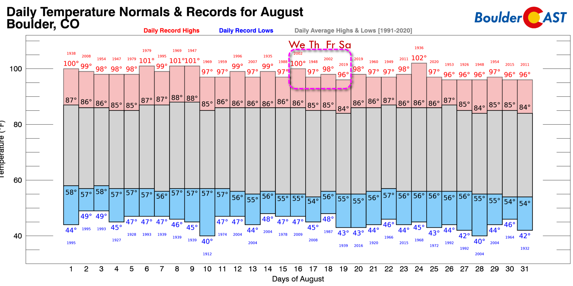
Tuesday will be just the tip of the iceberg (heat-berg?) though as temperatures will be even hotter the rest of the week for us. Wednesday and Thursday will top out in the middle 90s, with Friday looking to be even more oven-like in the upper 90s to near 100. These temperatures will be within a few degrees of record highs for many Front Range cities. In Boulder, the best chance of setting a daily record will be on Friday, but Thursday is a close second. Neither day looks like a guaranteed record-buster though, which is of course good news.
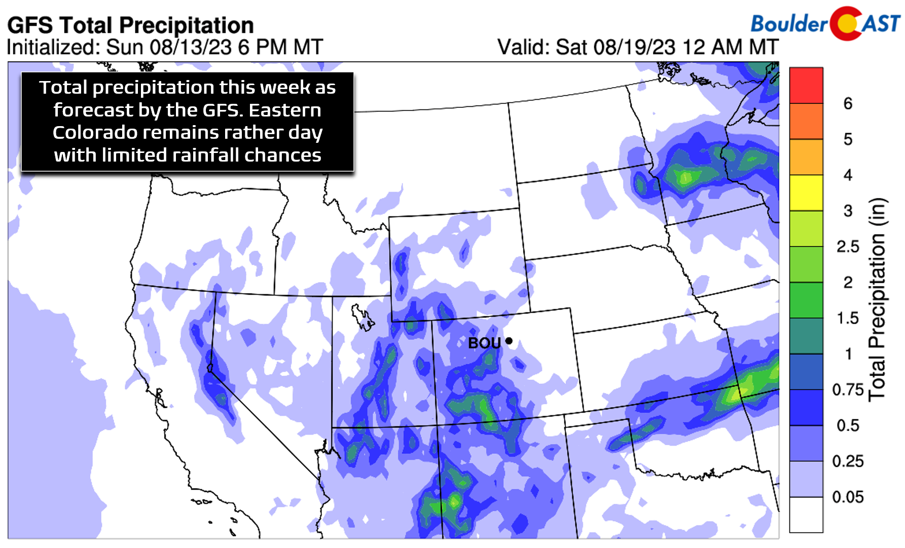
Rainfall chances, while not zero, will be minimal this week as relatively dry air and the strong ridge of high pressure help to keep things stable and mostly storm-free across the Front Range. Monday and Tuesday will definitely be dry with sunshine dominating. Storms return to our forecast Wednesday and thereafter, but things don’t look particularly favorable for much to go down outside of the terrain under downslope flow and with such warm air aloft.

Isolated to widely scattered storms enter the forecast beginning Wednesday as broad flow into Colorado begins to transition from northwesterly to southwesterly, a shift that will allow moisture levels to gradually increase over the area. By the weekend, true monsoonal flow may return to Colorado, though not all models agree on this facet just yet. It may end up being focused too far west.

Don’t get your hopes up though for rain. The primary headline is for a hot and mostly dry week ahead with very limited precipitation chances across the lower elevations. Western Colorado, particularly towards the San Juans, will see beneficial rains return by mid- to late-week. Unfortunately, many of us will be completely dry through Friday in the Denver-Boulder Metro area.
Here’s a look at our forecast for the week. We can already hear the collective “Ugh!” resounding from across the Front Range…
Finally, we wanted to mention that unlike the Atlantic Basin which is dead as a doornail, the Eastern Pacific Basin has really kicked into gear right now. Tropical Storm Dora, Tropical Storm Greg, and category 3 Hurricane Fernanda (animated below) are all active storms, with another new named storm likely to form in the coming days.

The Eastern Pacific tends to be most active in late August so things may continue to intensify. Right now the prevailing winds across the eastern tropical Pacific are not favorable for any cyclones to deflect northeastward and potentially impact the southwestern United States, but we continue to keep a close eye on things down that way.

Have a great week!
Forecast Specifics:
Monday: Morning clouds clear quickly giving way to sunshine. Temperatures remain very pleasant topping out in the upper 70s across the Plains with lower 70s in the Foothills.
Tuesday: Sunny skies and quiet, but the heat returns. Highs reach near 90 degrees on the Plains and into the upper 70s in the Foothills.
Wednesday: Mostly sunny and hot with isolated late-day thunderstorms, mainly in and near the higher terrain west and southwest of Denver. Temperatures in the middle 90s across the Plains with lower 80s in the Foothills.
Thursday: Sunny and hot with isolated late-day thunderstorms, mainly in and near the higher terrain west and southwest of Denver. Temperatures in the middle 90s across the Plains with lower 80s in the Foothills.
Friday: Mostly sunny and very hot with high temperatures near record values in the upper 90s on the Plains and in the middle 80s in the Foothills. A slight chance of a late-day storm, mainly west and northwest of the Denver Metro area.
DISCLAIMER: This weekly outlook forecast is created Monday morning and covers the entire upcoming week. Accuracy will decrease as the week progresses as this post is NOT updated. To receive daily updated forecasts from our team, among many other perks, subscribe to BoulderCAST Premium.
Go Premium, get all the perks.
Daily Forecast Updates
Get our daily forecast discussion every morning delivered to your inbox.
All Our Model Data
Access to all our Colorado-centric high-resolution weather model graphics. Seriously — every one!
Ski & Hiking Forecasts
6-day forecasts for all the Colorado ski resorts, plus more than 120 hiking trails, including every 14er.
Smoke Forecasts
Wildfire smoke concentration predictions up to 72 hours into the future.
Exclusive Content
Weekend outlooks every Thursday, bonus storm updates, historical data and much more!
No Advertisements
Enjoy ad-free viewing on the entire site.
Get BoulderCAST updates delivered to your inbox:
Enjoy our content? Give it a share!


You must be logged in to post a comment.