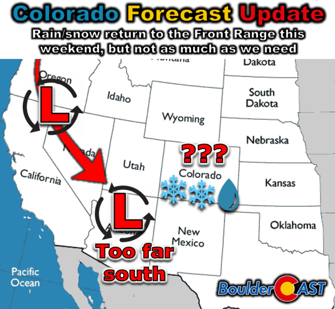
It’s been quite a long time since our last measurable precipitation in the Front Range, but that will change abruptly this weekend with the arrival of our next autumn storm system. Unfortunately the slow-moving low pressure will dive too far south into Arizona, largely fizzling out before ever reaching northeast Colorado. Nonetheless, it will bring a bit of rain, snow and much colder temperatures to our area for a few days. Read on for our latest thoughts on how the unsettled weekend ahead will play out. We also briefly review the entries to our 2024 First Snowfall Contest with predictions actually trending towards a later date than Boulder’s climatology would suggest (color us shocked!). There will indeed be some snowflakes in our forecast domain this weekend, but Boulder is not expected to see accumulating snow.
At a Glance:
- Incoming Autumn Storm: A strong storm system will bring rain and snow to the Front Range this weekend, but not as much as needed as it is tracking too far south. The storm will mostly affect southern Colorado and New Mexico with the heaviest rain and snow totals.
- Drought Conditions: Most of the Metro area is now experiencing some form of drought, with Boulder just being downgraded to Extreme Drought today, that worst it’s been in the county since the Marshall Fire.
- Weekend Forecast: Thursday will be warm with a few showers, Friday will see rain and mountain snow develop, and Saturday will have lingering light rain. We turn sunny and warm again by Monday.
- Snow Potential: Accumulating snow is expected, but mostly above 7000 feet elevation. Up to a trace could occur across portions of the lower elevations, but that is unlikely. On the opposite end of the spectrum, one lucky ski resort could see over 3 feet of snow by Sunday night!
- Watching Further Southward Trends: Recent model trends continue to take things further south. We’re really right on the edge of things now. Any further south and this may become a near non-event for us.
- First Snowfall Contest: We review the entries for our 2024 First Snowfall Contest, with predictions ranging from October 3rd to December 28th. Nearly 1/8th of contestants have already been eliminated in this warm and dry autumn so far!

Go Premium, get all the perks.
Daily Forecast Updates
Get our daily forecast discussion every morning delivered to your inbox.
All Our Model Data
Access to all our Colorado-centric high-resolution weather model graphics. Seriously — every one!
Ski & Hiking Forecasts
6-day forecasts for all the Colorado ski resorts, plus more than 120 hiking trails, including every 14er.
Smoke Forecasts
Wildfire smoke concentration predictions up to 72 hours into the future.
Exclusive Content
Weekend outlooks every Thursday, bonus storm updates, historical data and much more!
No Advertisements
Enjoy ad-free viewing on the entire site.
Precipitation finally returns, but not nearly as much as we need
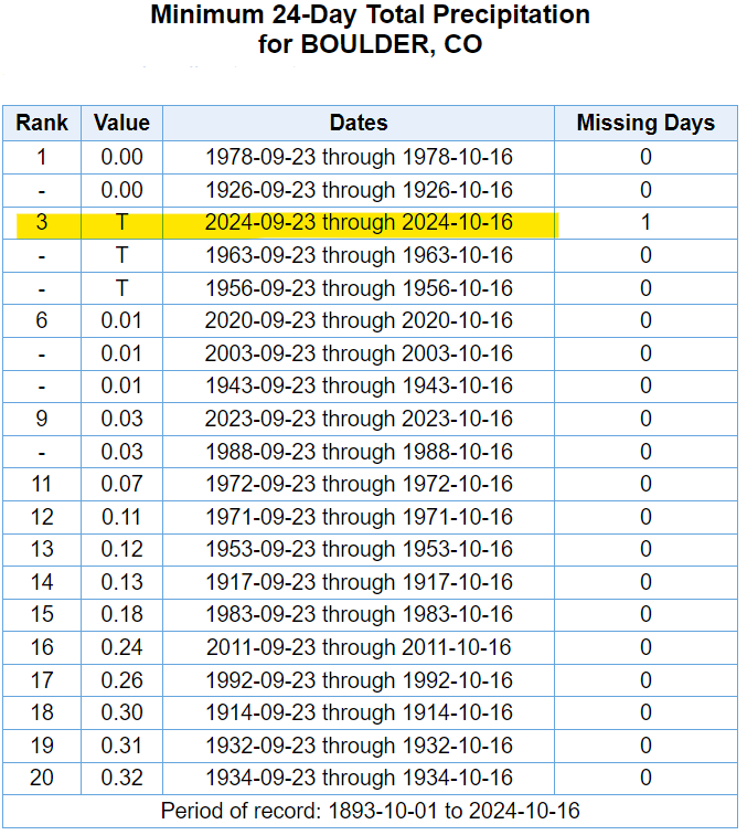
Thursday will likely be the 25th straight day in Boulder without measurable precipitation. Our last raindrops that were more than a spit occurred way back on September 22nd when nearly an inch of rain dumped from a classic upslope rainstorm. This recent parched stretch is tied for the third driest such period on record in Boulder — only bested (worsted?) by 1926 and 1978.
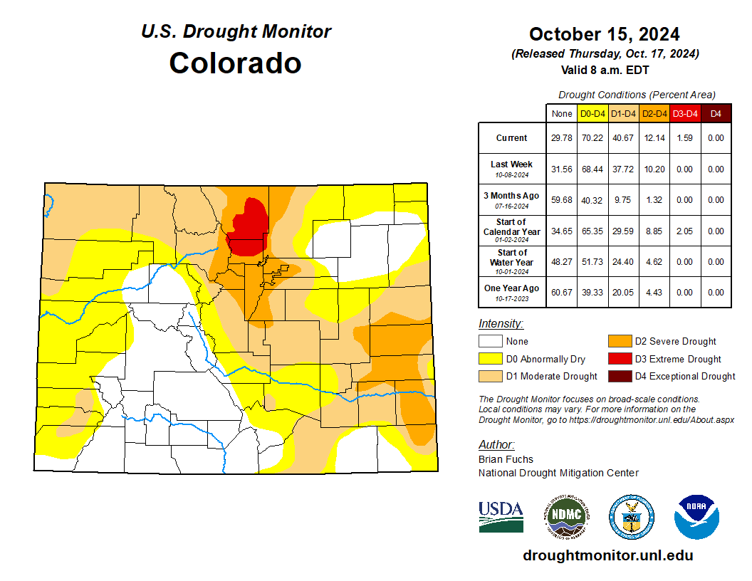
The latest Drought Monitor map released today downgraded parts of Boulder and Larimer Counties to Extreme Drought status — not a shocker given the complete lack of any precipitation the last several weeks. More than 50% of Boulder County is included in this worsened status, the largest such percentage since the lead-up to the Marshall Fire at the tail-end of 2021.
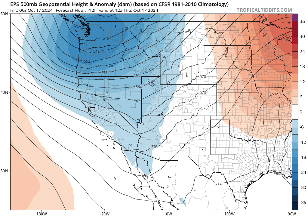
Fortunately we are here today to discuss the arrival of our next major autumn storm system, one which will finally seed to a return of widespread rain (and snow!) to the Front Range for the first time in nearly a month. We’ve been following this storm system all week long and uncertainty in the storm’s track and evolution has mostly been shored up now. The parent storm system is expected to drop like a rock, straight southward from the Pacific Northwest Thursday morning into northern Arizona by Friday night. The closed-low pressure will remain over the Grand Canyon area through most of the weekend while it slowly fills (i.e. weakens) before ejecting northeastward across Colorado late Sunday into Monday. This certainly isn’t the track we would draw up to maximize precipitation in the Front Range, it’s far too south and west when the storm will be at its strongest, but beggars can’t be choosers when we’re this dry. Every drop of rain or flake of snow counts!
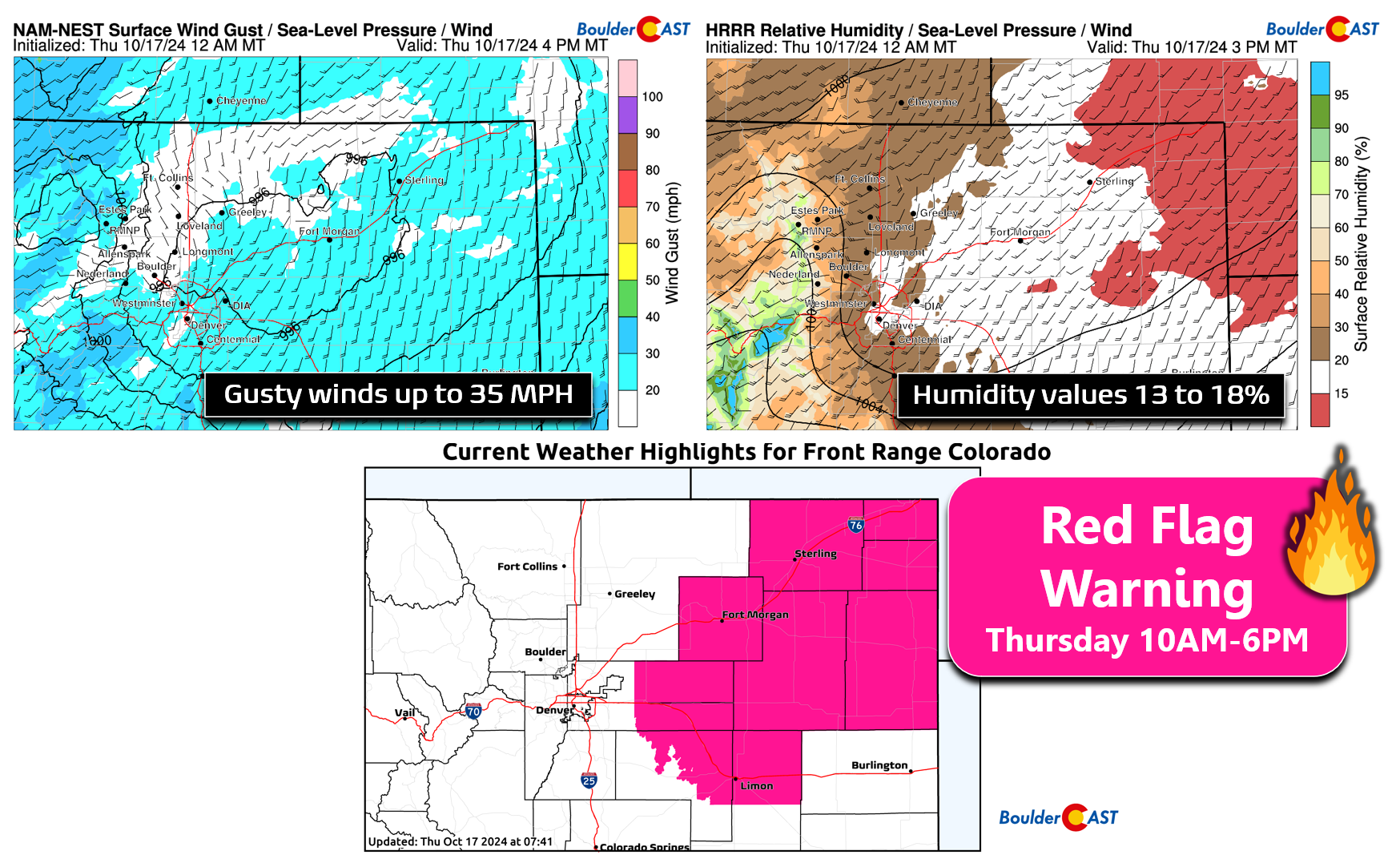
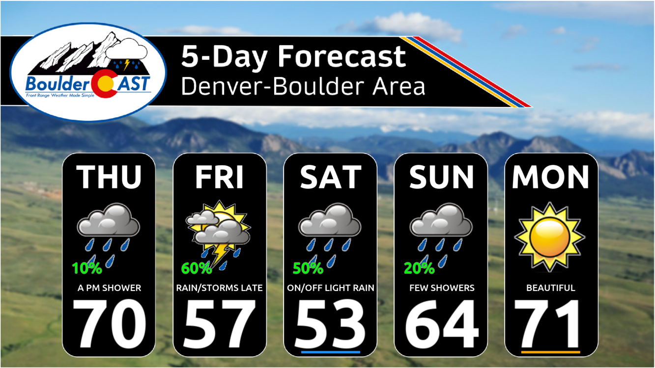
Thursday will be the classic “warm before the storm” with high temperatures remaining above normal for one last day, despite thick cloud cover. We should reach a high somewhere in the 70s Thursday afternoon with a few gusty showers developing across the region. These would produce just sprinkles at best but with gusty winds up to 30 MPH. Critical fire danger will exist Thursday as well, but only for areas east of Denver. Here is where Red Flag Warnings are in effect for the eastern Plains. It won’t be as warm, as dry or as gusty in the Metro area, but fire danger is still elevated here too so do use caution!
As the storm system drops southward across Utah on Friday morning, rain and Mountain snow will spread into western Colorado. It’s not until Friday afternoon/evening when we expect precipitation to being to bubble into the Front Range. Initially there will be some instability to support isolated thunderstorms across the Denver Metro area Friday afternoon and early evening, but as chillier upslope filters in Friday night, this will switch to a stratiform precipitation event. High temperatures on Friday will only be in the 50s with overcast skies.
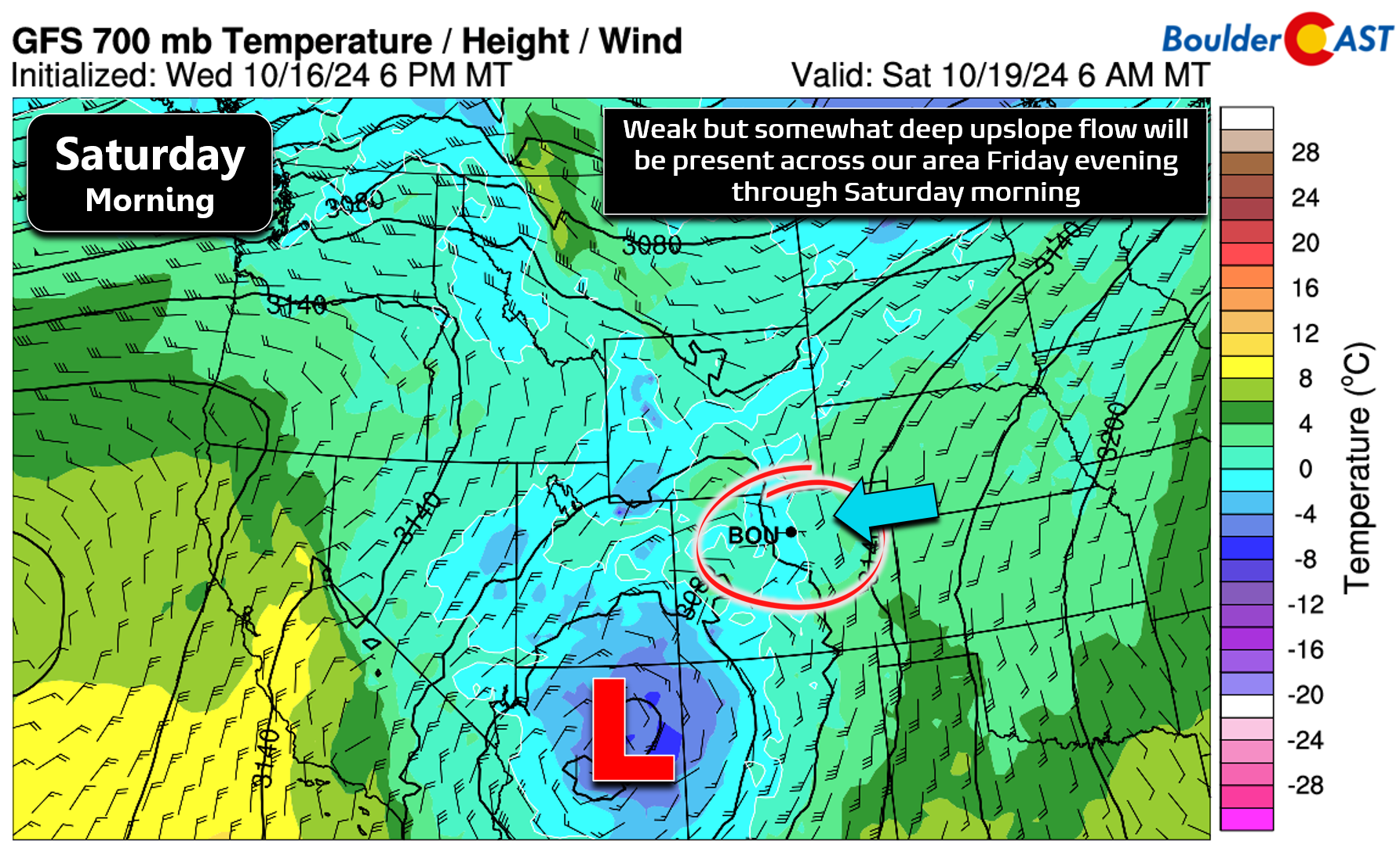
Upslope flow, while not particularly potent, will linger across our area from Friday evening until about midday Saturday. This is the timeframe when we expect most of our precipitation to fall this weekend.
Things won’t dramatically dry out on Saturday though. There’s still a chance that light rain showers or drizzle will be around during the day into Saturday evening. A look at the latest ensemble plumes below helps show the timing of potential precipitation in our area. The main window for rain is Friday PM to Saturday PM, with on-and-off mostly light showers possible during this timeframe. A secondary, though somewhat uncertain round of light rain may occur on Sunday as the low pressure finally ejects towards Colorado.
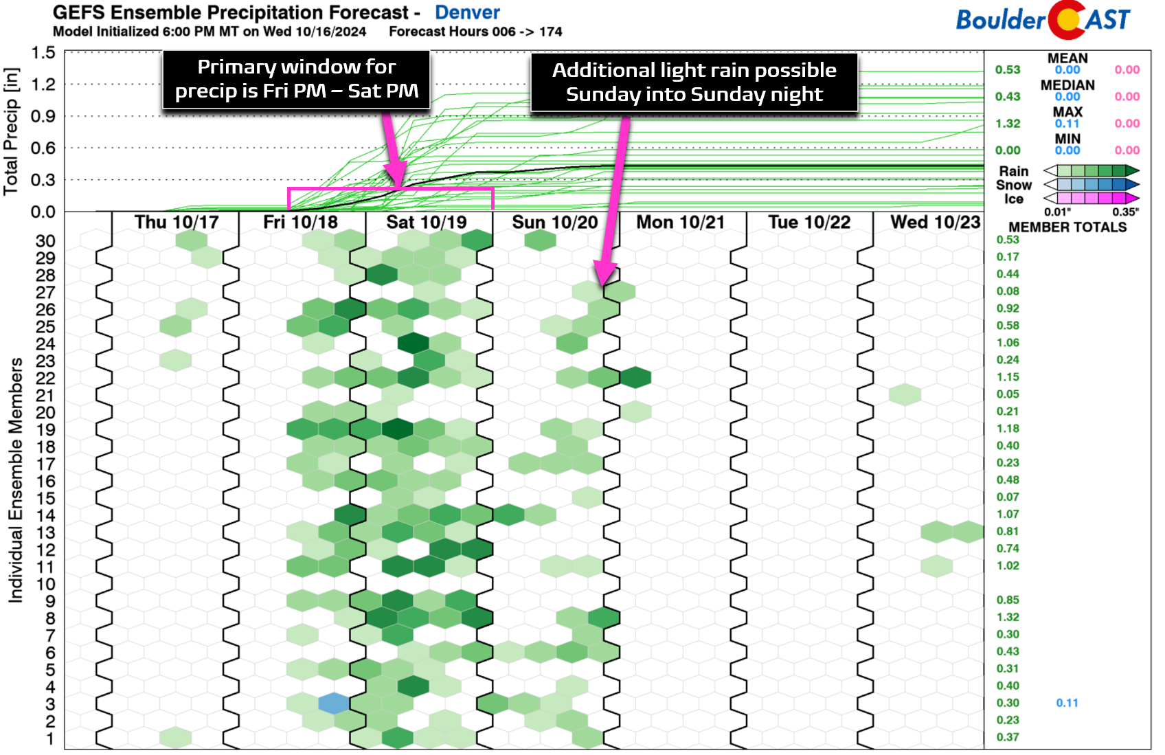
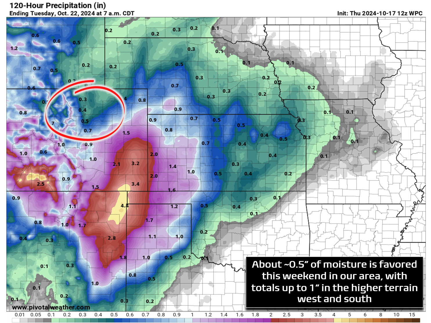
As noted via the green lines in the graphic above, the ensemble spread in rainfall totals for the Boulder-Denver area is still rather large, with no clear consensus on how much rain we will actually stumble into this weekend. The ensemble median and mean are around 0.4-0.5″ in Denver, though the recent trends have these values tumbling further. As we already mentioned, the track of this particular low pressure is unfortunately too far southwest when the storm will be at peak intensity. By the time it moves across our area Sunday, it will be just a ghost of its former self. Southern Colorado and New Mexico will benefit much more this weekend, with 1-2″+ of rain possible down there. In our neck of the woods, we’ll be lucky to pick up a half inch of liquid, with even lower totals north of Denver. Our best forecast right now is for 0.1 to 0.5″ of rain in the Metro area — not a ton but enough to wet the parched vegetation and soils.
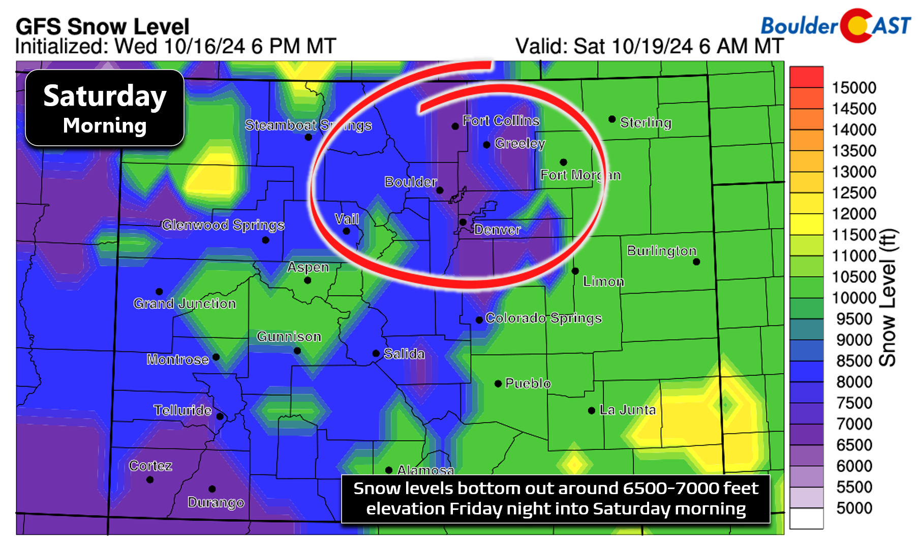
One big question remains — the one we’ve been asked so many times the last few days — will it snow this weekend across the lower elevations? While earlier model runs this week did hint at a low-end chance of minor snow accumulations in Denver and Boulder, those solutions have all but vaporized given the final track of the low pressure — it’s too far away to provide enough “oomph” to pull down the truly cold air. During the coldest period of the storm, which will conveniently overlap with our best precipitation chances this time around, snow levels only come down to around 6500 feet Friday night into Saturday morning. Temperatures across the Plains will be in the mid to upper 30s at this time, but there’s almost no model support for any freezing precipitation reaching the ground. There will be plenty of chilly rain to go around across the lower elevations, but unfortunately it doesn’t look like there’ll be any snow. We can’t fully rule out a couple snowflakes mixing in across some of the higher neighborhoods of the Metro area (5800+ feet), but this event will almost exclusively be light rain for the bulk of the Metro area.
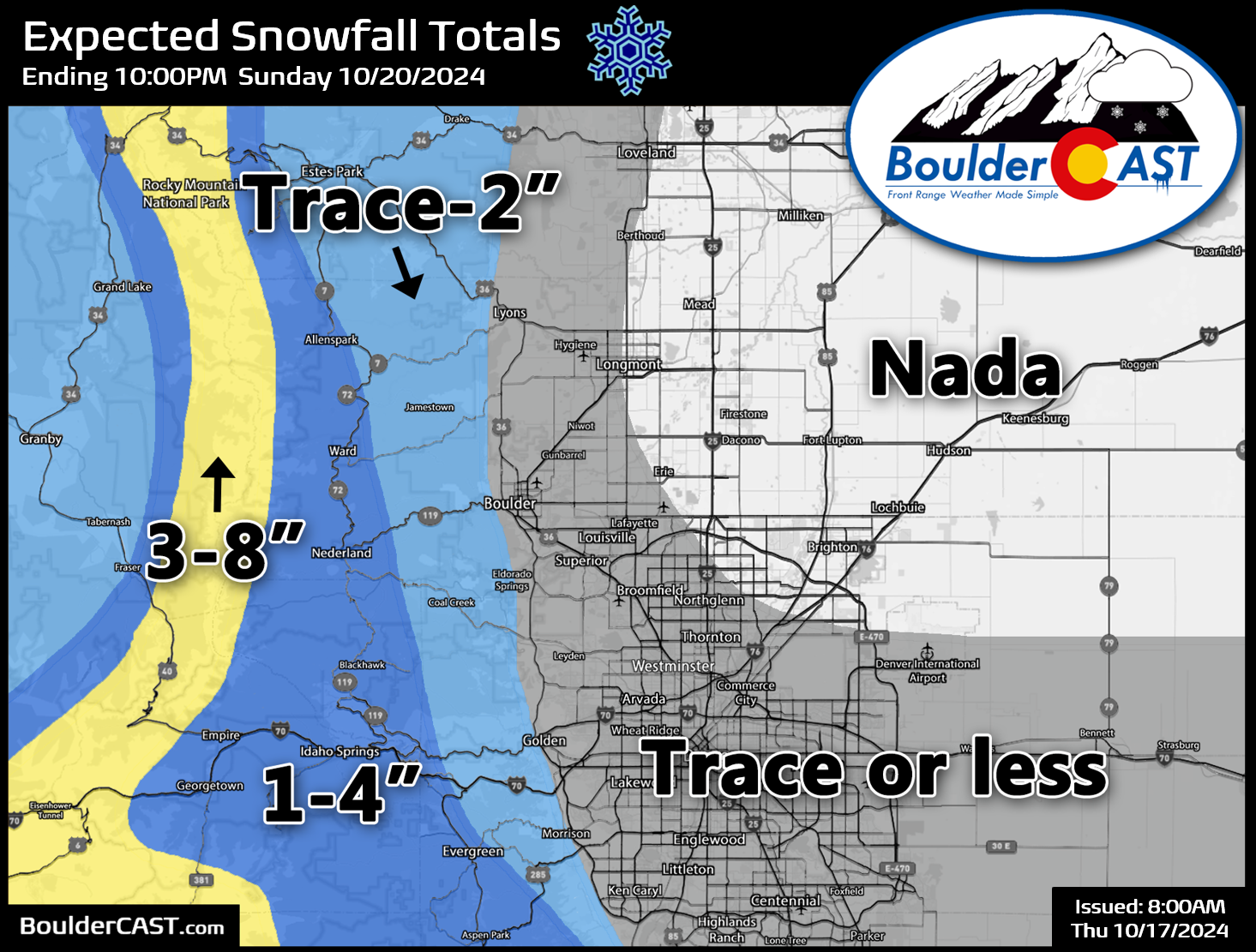
Our snowfall forecast map for the event is shown below covering all snow through Sunday night. It’s good to get our first official snow map for the 2024-2025 snow season out of the way, even if expected amounts are on the miniscule side. The best chance to see actual snow accumulation late Friday into Saturday will be above 7000 feet in the Foothills where up to 4″ may fall. Up to 8″ is possible above 10,000 feet, including high mountain passes like Eisenhower Tunnel and Trail Ridge Road (which may fully close for the season this weekend). Minor snow accumulation could occur as low as 6000-6500 feet, maybe up to 1″ in spots, but temperatures will be marginal here as well. Most accumulating snow in the High Country will be over and done with by late Saturday morning, after which precipitation chances will decline and snow levels will rise up once again.
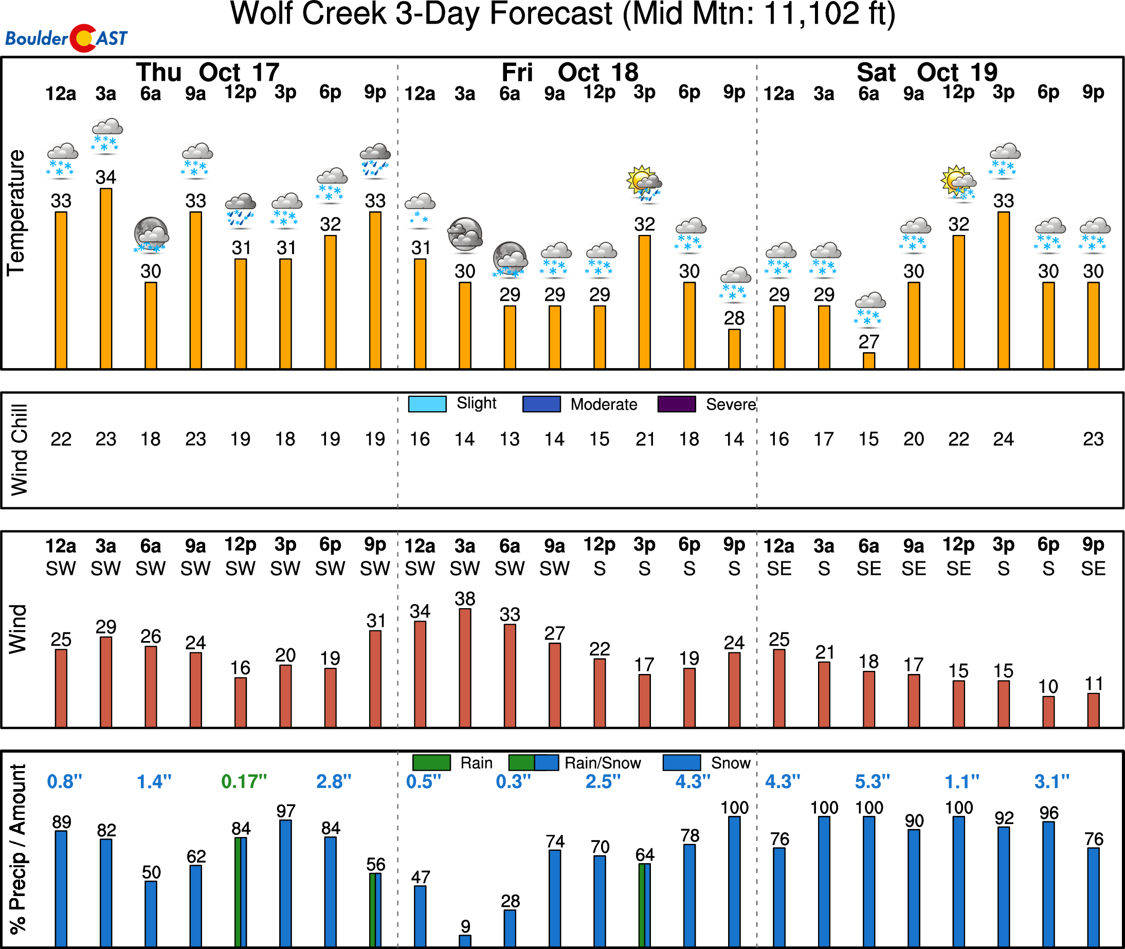
Much (much!) more snow is expected across the San Juan Mountains of southwest Colorado this weekend, which will be closer to the stalled-out Arizona low pressure the next several days and directly in line for a huge plume of moisture surging northward east of the low.
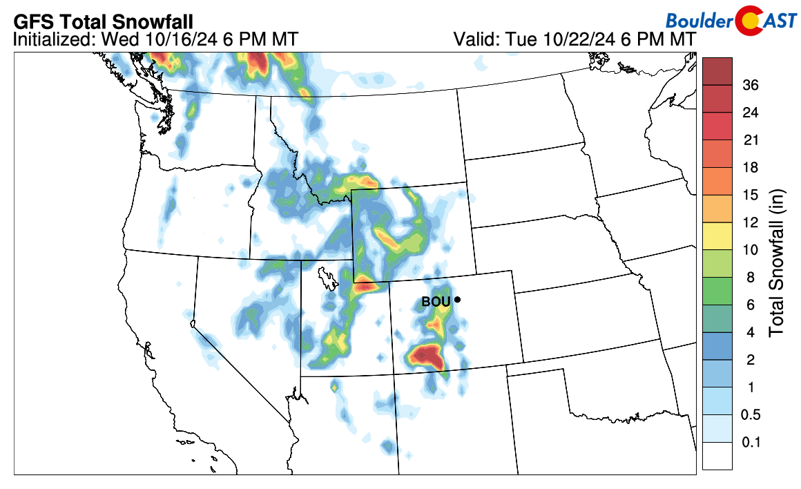
PowderCAST shows the heaps of snow expected across the ski resorts of southwest Colorado — some places like Wolf Creek could receive more than 3 feet of white stuff when all said and done!
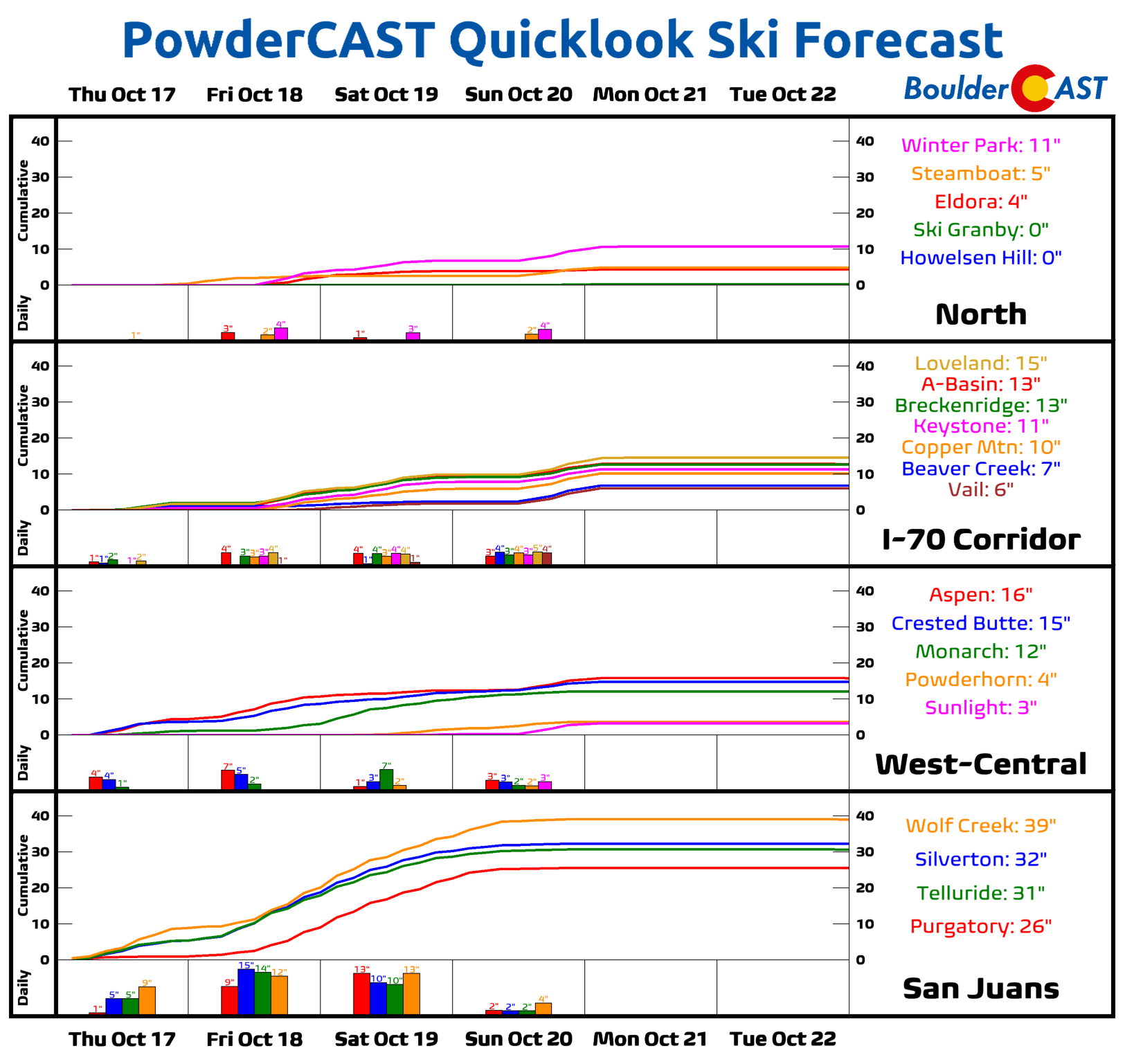
Look at all that snow! With temperatures in the upper 20s to lower 30s most of the time, it won’t exactly by powder there either!
Overall, this potent storm will unfortunately not paint the Front Range with as much moisture as we need, but it is a step in the right direction. We’ll need to keep a close eye on model trends over the next 24 hours as recent runs have started to take thing even further southward, possibly pushing this towards a near non-event for us. We do have one final nugget of good news for the gardeners, farmers and pumpkin-patch enthusiasts out there — there’s not likely to be frost this weekend given there will be extensive cloud cover locked in across the area and the lack of sufficiently cold air. It’s possible that we could see patchy frost develop Sunday night with skies clearing, so do keep a watchful eye on how that aspect on the backend of the forecast evolves. Things will clear out nicely by Monday for us with sunny and fairly warm weather returning heading into early next week.
While our first accumulating snow of the season will hold off a little while longer, read on into the section below for a review of all the entries to our 10th Annual First Snowfall Contest below. Enjoy the cooler, wetter and more seasonal weekend ahead!
A review of the 2024 First Snowfall Contest entries
n the announcement post for this contest, we offered a little insight by providing a few of Boulder’s “first snow” statistics. More than 270 of you came up with “educated” guesses for the timing and amount of Boulder’s first snow of the 2024-25 winter season. All of the entries are contained in the calendar view below. Click to enlarge or head over to the official Google Sheet for a clearer look at things.
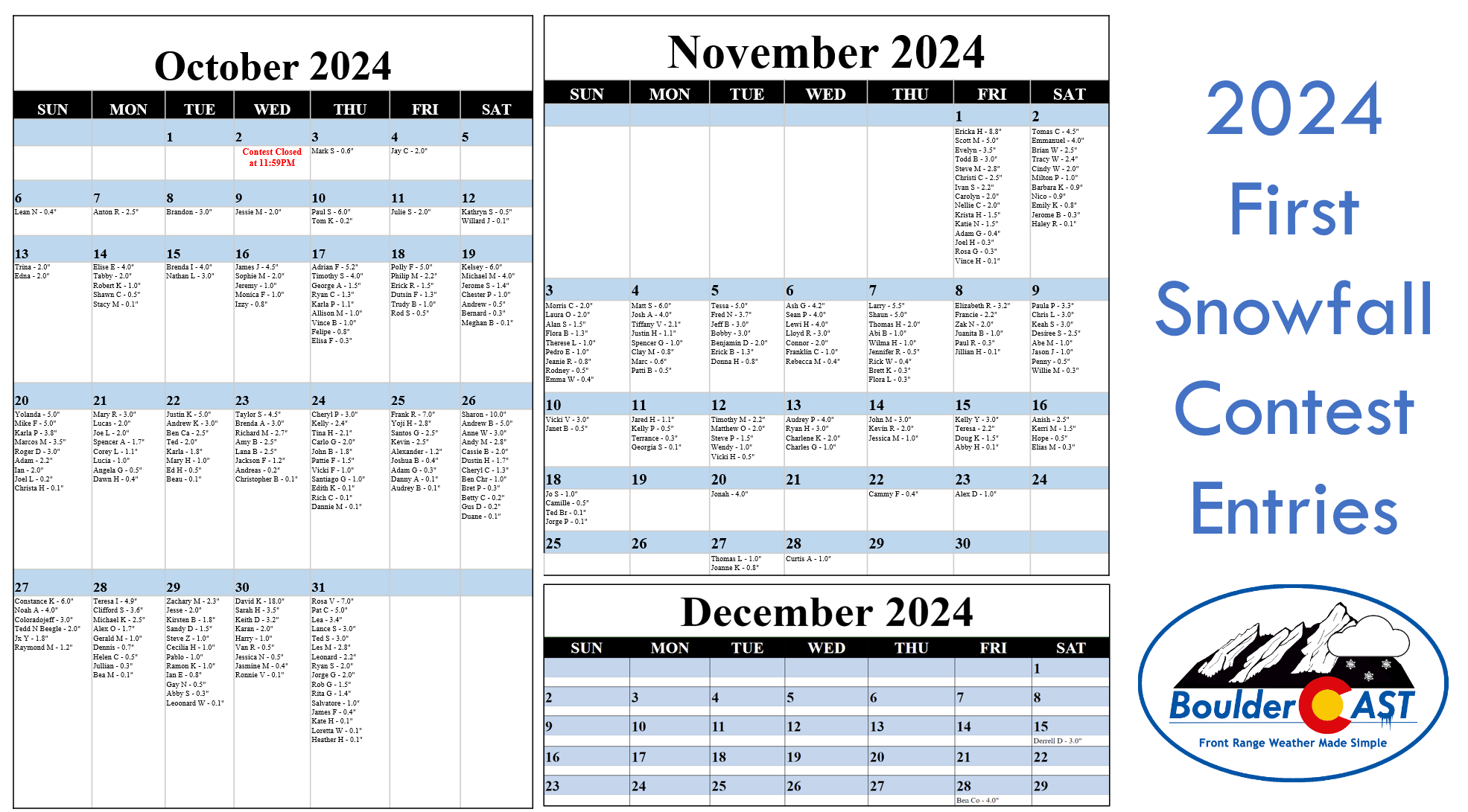
A few notes about the predictions:
- Dates range from October 3rd to December 28th, the latter being nearly six weeks later than the existing latest first snow on record for Boulder! Our readers are really pessimistic aren’t they?
- Amounts range from 0.1 to 18.0 inches. Keep in mind there’s only been one first snow in the last 75 years that was greater than a foot!
- The median date of the guesses is October 29th. This is nine days later than climatology, perhaps a sign of public sentiment being marred by the recent prolonged warm pattern
- The most popular date chosen was October 31st with sixteen picks — no doubt influenced by the long-standing Denver area urban legend that our first snow is always on Halloween!
- 90% of entries predict a first snow of 4.0 inches or less. Bravo, climatology strongly agrees with these folks!
- Due to our procrastination in ingesting the entries, about 12% of contestants have already been eliminated thanks to the warm month of October weather so far. Better luck next year!
SUMMARY OF SCORING:
Those who come closest to the actual date of Boulder’s first MEASURABLE SNOW (defined as snowfall at or above 0.1″) win! For verification, we’ll go off the official Boulder climate station located at the NIST building in south Boulder. Only the first calendar date of snow will be used (i.e. if the first snow event spans two days, only the amount of the first day will count). In the event that multiple participants select the same date, the tie-breaker of snowfall amount will be used.
SUMMARY OF PRIZES:
The prizes for the contest are as follows:
- 1st place: 12-month Premium subscription + $35 Amazon Gift Card
- 2nd place: 6-month Premium subscription + $15 Amazon Gift Card
- Anyone who guesses within 1 day OR 0.1″ correct: 2-month Premium subscription
- All other entries: Virtual “pat on the back”
WRAP UP AND GOOD LUCK!
2024 First Snowfall Contest prizes and recognition will be awarded in the days following our first dump of snow. See below for a summary of the scoring and prizes. Though our first snow likely won’t be this weekend, let’s hope it comes sooner rather than later. Good luck, all!
Get BoulderCAST updates delivered to your inbox:
Go Premium, get all the perks.
Daily Forecast Updates
Get our daily forecast discussion every morning delivered to your inbox.
All Our Model Data
Access to all our Colorado-centric high-resolution weather model graphics. Seriously — every one!
Ski & Hiking Forecasts
6-day forecasts for all the Colorado ski resorts, plus more than 120 hiking trails, including every 14er.
Smoke Forecasts
Wildfire smoke concentration predictions up to 72 hours into the future.
Exclusive Content
Weekend outlooks every Thursday, bonus storm updates, historical data and much more!
No Advertisements
Enjoy ad-free viewing on the entire site.
Enjoy our content? Help us out and give it a share:


You must be logged in to post a comment.