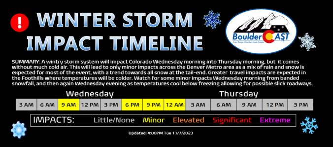
A wintry storm system will impact Colorado Wednesday morning into Thursday morning, but it’s not bringing much cold air to the party! This will lead to only minor impacts across the Denver Metro area as a mix of rain and snow is expected for most of the event, with a trend towards all snow at the tail-end as precipitation will be wrapping up. Greater travel impacts are expected in the Foothills where temperatures will be colder and up to 8 inches of snow may accumulate. We discuss the timing of the rain and snow, the expected snowfall totals for everyone and when travel may be most impacted.

Go Premium, get all the perks.
Daily Forecast Updates
Get our daily forecast discussion every morning delivered to your inbox.
All Our Model Data
Access to all our Colorado-centric high-resolution weather model graphics. Seriously — every one!
Ski & Hiking Forecasts
6-day forecasts for all the Colorado ski resorts, plus more than 120 hiking trails, including every 14er.
Smoke Forecasts
Wildfire smoke concentration predictions up to 72 hours into the future.
Exclusive Content
Weekend outlooks every Thursday, bonus storm updates, historical data and much more!
No Advertisements
Enjoy ad-free viewing on the entire site.
Snowflakes return Wednesday
This beautiful Tuesday has been our fifth 70°+ outing already in November, just seven days into the month. This includes the record high temperature we tied on Sunday reaching 78°F in Boulder and Denver alike. For reference, the all-time maximum number of 70-degree days in a given November is 10 which occurred in 2021, 2017, and 1999.
It was warm Sunday. That is all. #COwx #Boulder #Boulderwx pic.twitter.com/wPPRJG0FwP
— BoulderCAST Weather (@BoulderCAST) November 6, 2023
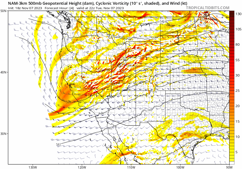
This unseasonable warmth is about to conclude across the Front Range with our next storm system, a well-advertised one, approaching from the Pacific Northwest. The vorticity forecast animation below shows how this trough axis will evolve between now and Thursday night. Basically the trough will shear out and weaken as it enters our area, with some energy from the trough getting stuck across southern Colorado into Friday. Most of the energy will pull south of the Front Range by sunrise on Thursday. However, between now and then, we have some interesting weather to discuss!
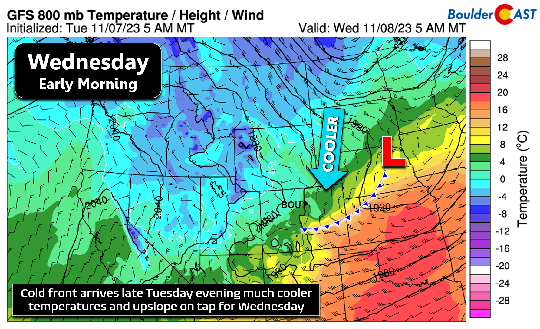
First and foremost, the initial surface cold front will precede the arrival of the trough by many hours — the front is currently slated to move into the Denver Metro area late Tuesday evening. By early Wednesday morning, the surface front will be well south of our area. One important thing to note is that the air behind the front isn’t all that cold. They way the trough shears out prevents the coldest air from getting drawn into Colorado, instead sweeping it eastward into the Dakotas and northern Plains. This is one reason the forecast for this event is tricky — temperatures won’t be cold enough for accumulating snow the entire time. We may even see some rain mix in. For now, just be aware this system is lacking cold air!
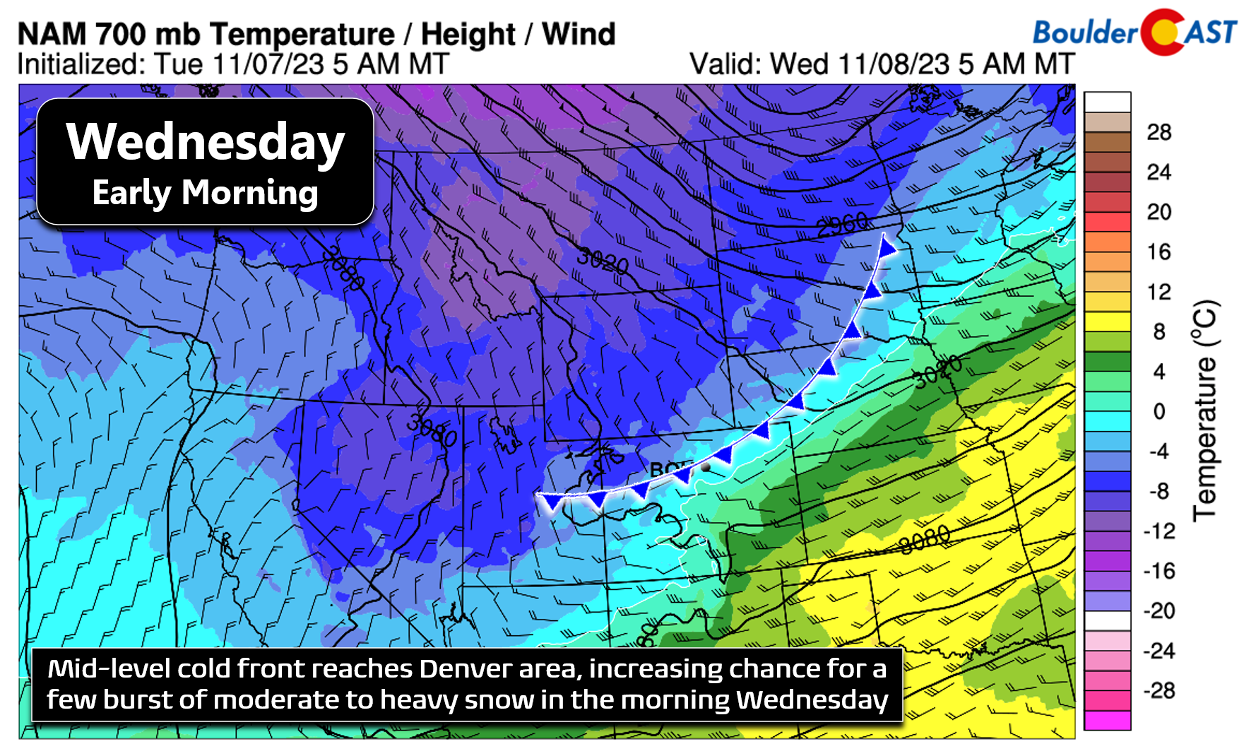
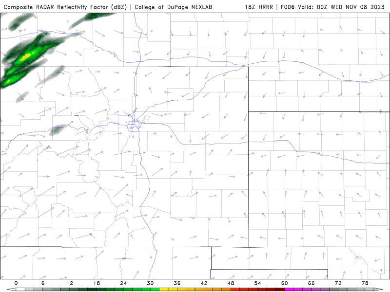
Precipitation should commence sometime Wednesday morning in our area, likely around the commute window, when the mid-level cold front shows up from the northwest. Between this frontal forcing and the passage of a jet-streak aloft, we expecting to see some banded precipitation with embedded bursts of moderate to heavy snow. Unlike our last snowstorm, the window for this banding will be brief — just a couple of hours Wednesday morning.
The HRRR simulated radar animation below shows us how things may go down on Wednesday. The banded precipitation sags southward early Wednesday morning. Keep in mind that sub-freezing temperatures will be tough to come by Wednesday morning, with models showing heavy snow in the Foothills but a mix of rain/snow across the lower elevations with temperatures in the middle to upper 30s or so. The timing on this banded precipitation isn’t great — it could land smack in the middle of the commute window. However, we do expect most of the snow that may be falling to melt off roadways with ease — despite there being potentially some big snowflakes pounding in spots. A quick inch or so on the grassy surfaces may be possible with this initial wave of precipitation Wednesday morning. It really depends on the exact temperatures and snowfall rates. It won’t be much, though.
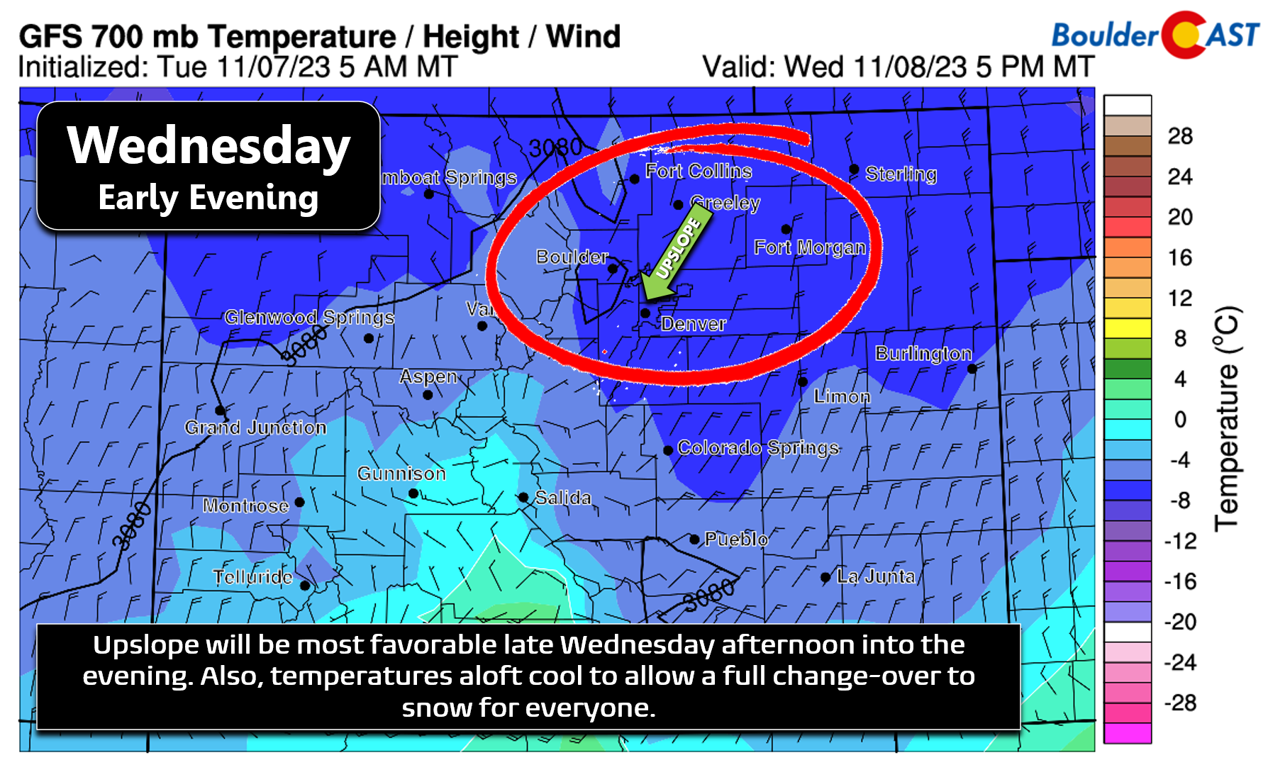
As the jet and frontal forcing head off to the south around midday Wednesday, upslope will begin to set in across the Front Range reinvigorating the precipitation towards the terrain. Upslope efficiency has been decreasing in recent model runs, but it will have a northeasterly direction and reach ~20 MPH at the 10,000-foot elevation level. This direction would most favor Jefferson County in the Metro area, but Boulder County should still do okay, too. Larimer will not benefit much from this upslope.
Temperatures will remain above freezing in Boulder and Denver during the day Wednesday with a mix of rain and snow at times — so whatever happens won’t be accumulating much. Higher up in the Foothills, it will be an all-snow event with pockets of moderate to heavy snow expected throughout Wednesday. By afternoon and early evening, especially after sunset, temperatures will cool enough in the Metro area to allow for the snow to accumulate better — and for areas that were seeing rain to switch over to snow. Still, locations away from the terrain likely won’t see much accumulation from this storm at all. Boulder, Golden, Roxborough, and Littleton have the best chance to see an inch or two of slushy accumulation on the grass. But even still, less than 1″ is the most likely outcome in these western suburbs.
Our snowfall forecast map for this event is shown below. This covers all snow falling through Thursday morning when we expect things to quickly clear out from north to south, possibly even before sunrise. The most accumulation with this storm, 4 to 8 inches worth, will be in the Foothills above 7500 feet elevation where temperatures will be cold enough for snow to stick the entire time. The lower Foothills between 6000 feet and 7500 feet can expect 1-4″. Down on the lower elevations, temperatures will be too warm and generally less than 2″ is expected on grassy and elevated surfaces.
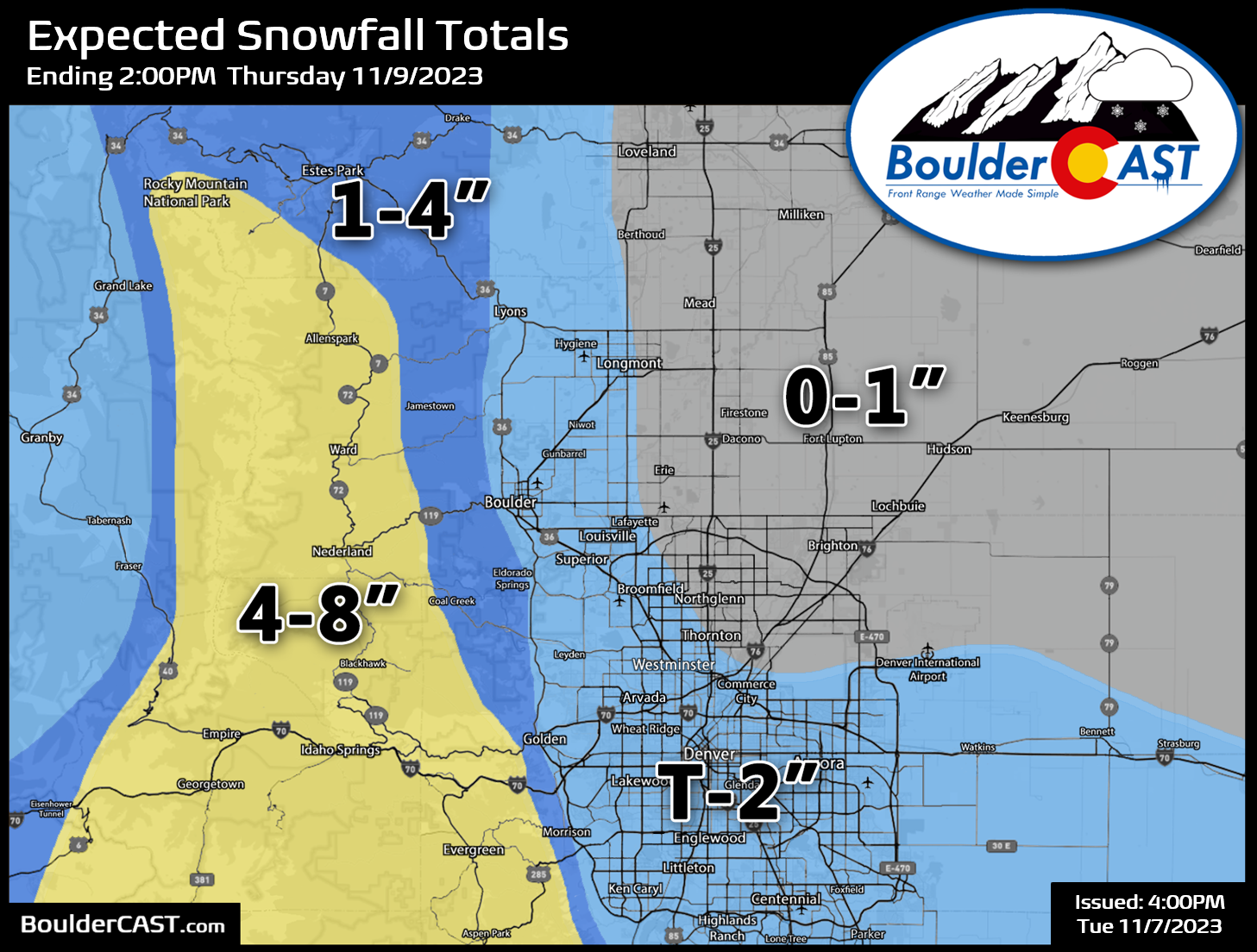
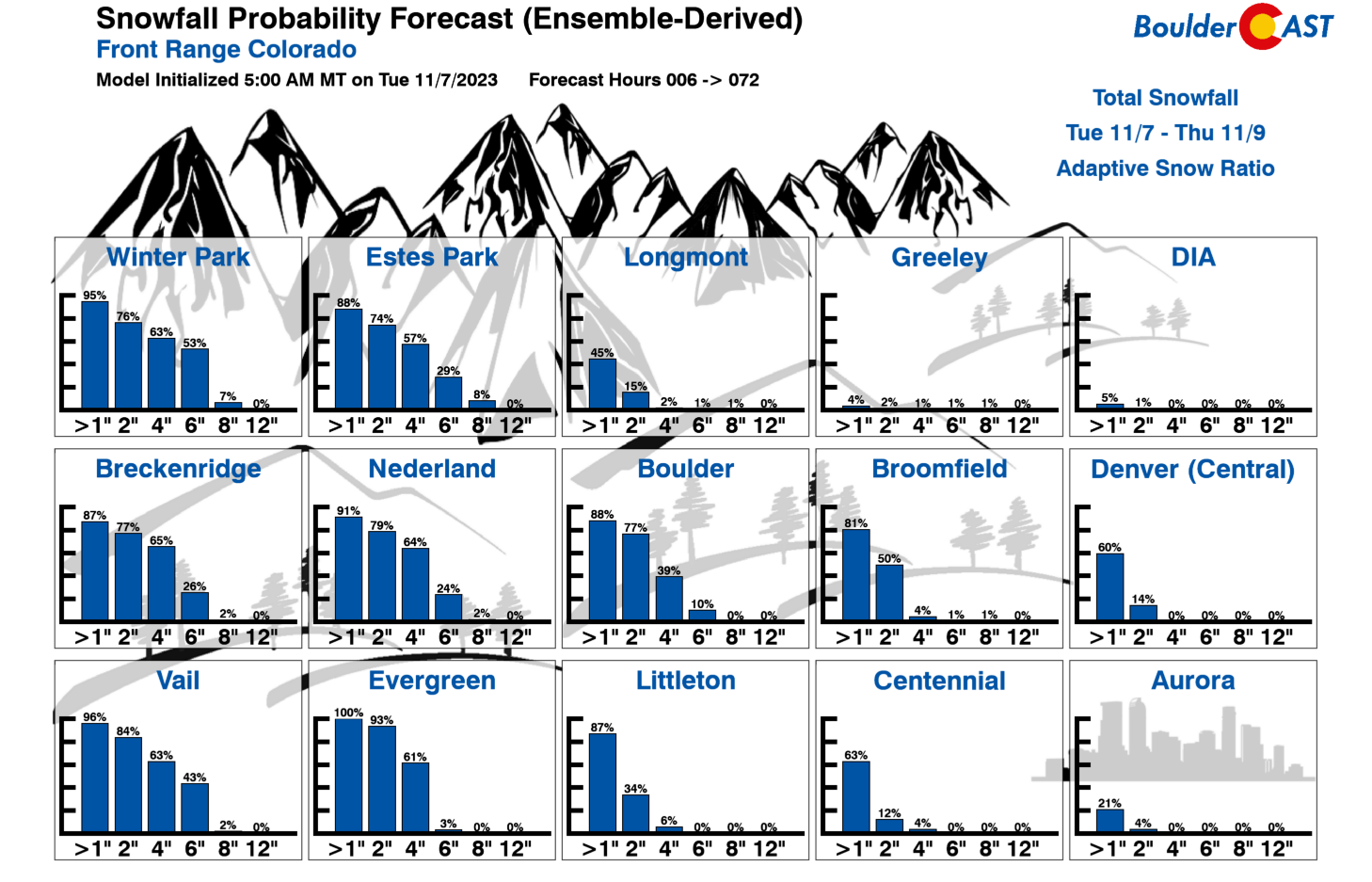
Our latest Snowfall Probabilities clearly indicate this is a low impact event, and even borderline no impact event, for the lowlands!
As for travel impacts, we’re not expecting much outside of the Foothills and the eastern slopes of the Front Range Mountains. The more intense band of precipitation could cause minor issues for the morning commute but roads will stay just wet. After the sun goes down Wednesday evening, we could see a few slick spots develop where snow lingers. This should mainly be south and southwest of Denver, including across the Palmer Divide.

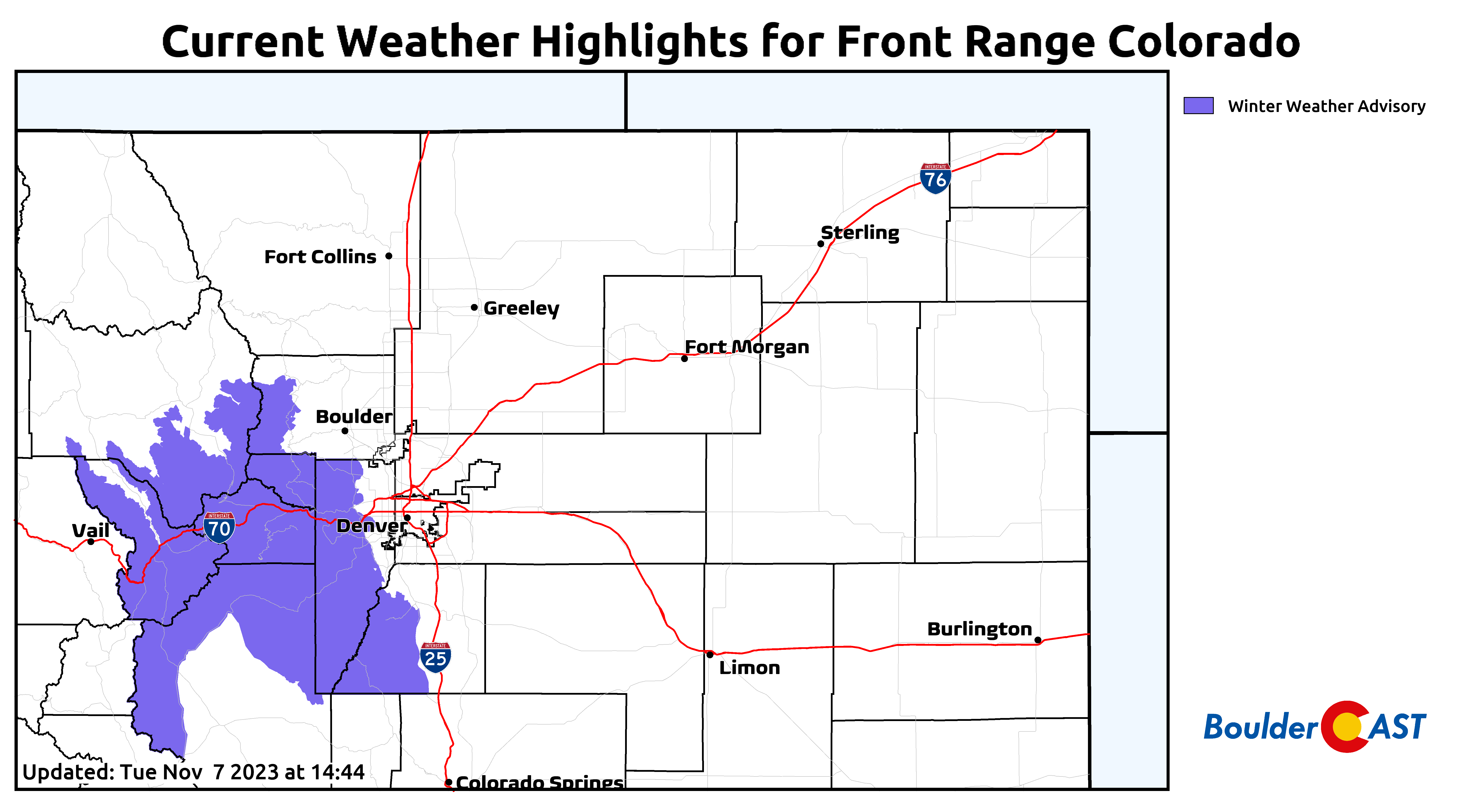
A Winter Weather Advisory has been posted for the southern Foothills and Mountains. It goes into effect at 6AM Wednesday and runs until midnight Wednesday night. Expect winter driving conditions above 7500 feet tomorrow, including most of I-70 up to the Eisenhower Tunnel.
Things will quickly clear out Thursday morning leaving behind sunny skies and chilly temperatures in the upper 40s for highs. A warming trend will ensue into the weekend reaching back above normal into the lower 60s by Sunday.
That’s all we have for now. We’ll pass along a few updates on social media as needed and via our morning Premium Storm Update on Wednesday. Think snow!
Get BoulderCAST updates delivered to your inbox:


You must be logged in to post a comment.