What a wonderful weekend it was across the Front Range culminating with sunshine and record high temperatures on Sunday! The warmth will continue for just a couple more days here before a midweek weather system will usher in much colder temperatures alongside the threat of rain and snow, including potential heavy snow in the Foothills. Uncertainty remains elevated for this storm overall, but change is definitely headed this way. Read on for the latest details.
This week’s highlights include:
- Record high temperatures were observed on Sunday in Boulder and Denver — that trend will continue early in the week with well above normal temperatures
- Monday and Tuesday will be pleasant and warm with highs in the lower 70s, at times it will be breezy
- Our main weather system of the week arrives quickly Wednesday with chances for rain/snow in the Front Range
- We’re expecting a decently long period of deep upslope into the Metro area favoring the Foothills and eastern slopes along the Divide for heavy snow, but impacts across the Metro area look to be relatively minor, especially east of Interstate 25
- Still quite a bit of uncertainty with the midweek system — stay tuned for updates!
- The late-week period will be quiet and dry but stays chilly with 40s and 50s for highs

DISCLAIMER: This weekly outlook forecast is created Monday morning and covers the entire upcoming week. Accuracy will decrease as the week progresses as this post is NOT updated. To receive daily updated forecasts from our team, among many other perks, subscribe to BoulderCAST Premium.

Go Premium, get all the perks.
Daily Forecast Updates
Get our daily forecast discussion every morning delivered to your inbox.
All Our Model Data
Access to all our Colorado-centric high-resolution weather model graphics. Seriously — every one!
Ski & Hiking Forecasts
6-day forecasts for all the Colorado ski resorts, plus more than 120 hiking trails, including every 14er.
Smoke Forecasts
Wildfire smoke concentration predictions up to 72 hours into the future.
Exclusive Content
Weekend outlooks every Thursday, bonus storm updates, historical data and much more!
No Advertisements
Enjoy ad-free viewing on the entire site.
Two more days of warm weather
The weather over the weekend was absolutely gorgeous across the Front Range, culminating with record warmth on Sunday in the middle to upper 70s across the lower elevations. We hope you took advantage of the nice weekend weather!
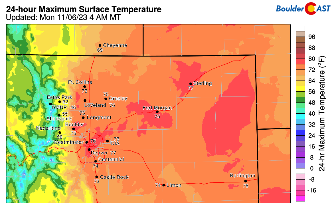
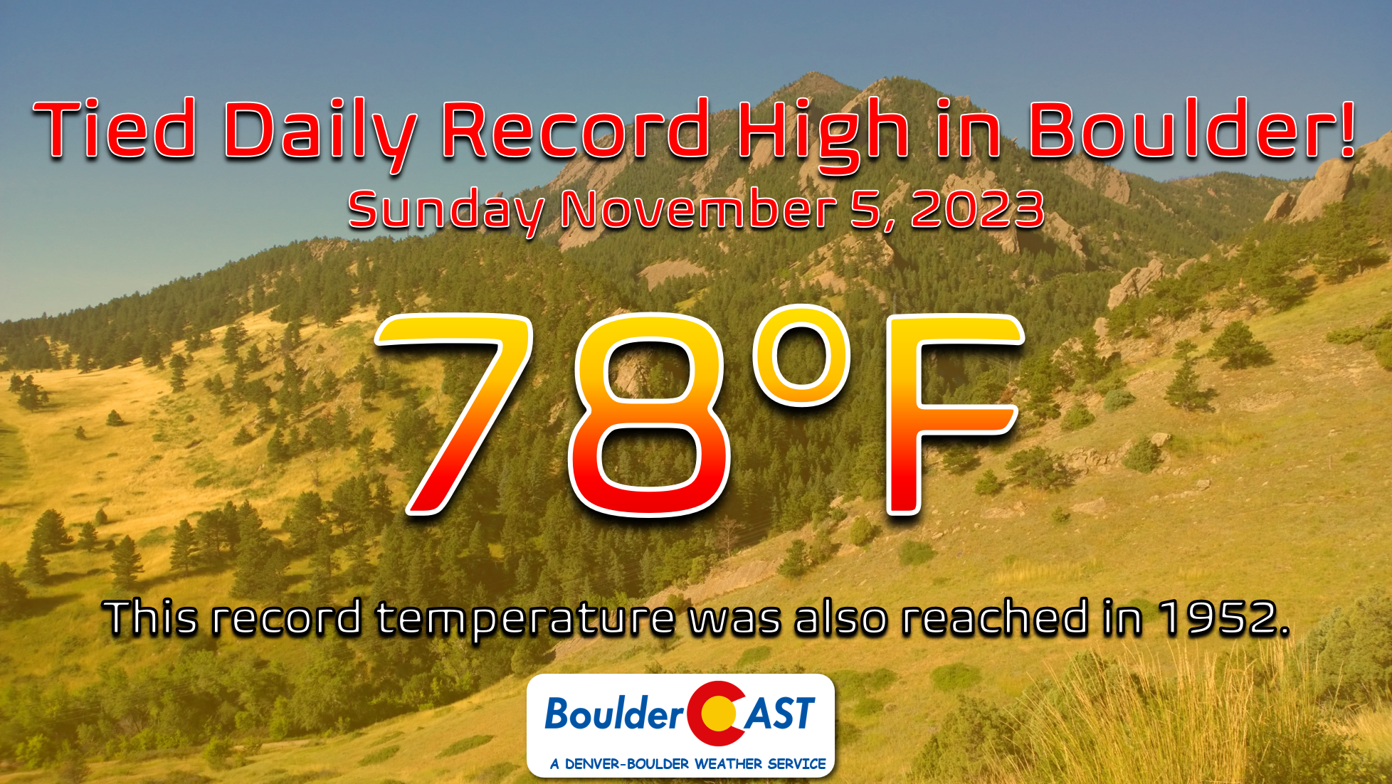
Boulder tied its existing record high temperature for November 5th soaring to 78°F Sunday afternoon (and came up just shy of the all-time monthly record high of 80°F). This record temperatures was previously notched in 1952, so it’s been a solid 71 years since we’ve been that warm on November 5th. Denver managed to break its record high for the date, also reaching 78°F.
As we begin the new week, the pattern will remain largely unchanged, albeit slightly cooler following a weak overnight cold front which clipped the area. Broadly speaking, though, the entire West will stay under quasi-zonal flow through Tuesday with limited moisture as a trough approaches from the Pacific Northwest. Under this downslope setup, the Denver Metro area will continue to see above normal temperatures both Monday and Tuesday this week with highs around 70 degrees.

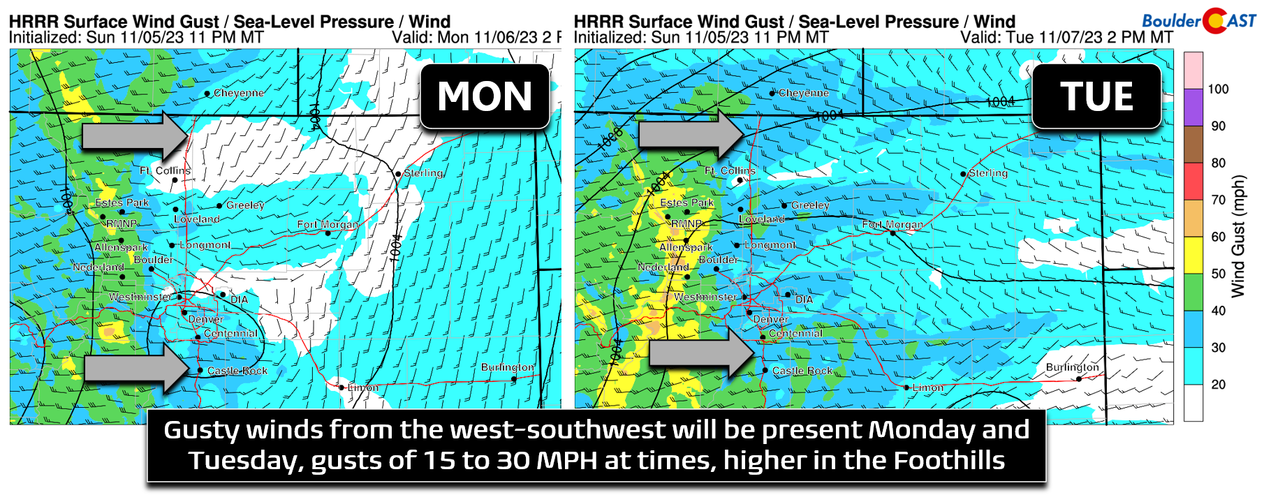
That moderate west-southwest flow aloft will mix down to the surface early in the week with breeziness expected across some of our area. Both Monday and Tuesday should see gusts of 10-15 MPH (and even higher in the Foothills/Palmer Divide). Tuesday appears to be the gustier day overall for the Front Range.
The aforementioned zonal flow over the area will not be completely devoid of moisture early in the week. A look at GOES-East nighttime imagery from early Monday morning (below) has quite a bit of wave clouds over Colorado, as well as plentiful clouds upstream over Utah and the Great Basin.
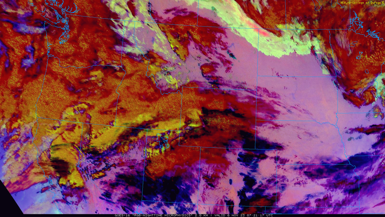
With this, we don’t expect to see any completely sunny skies to start the week. Monday will be partly cloudy while Tuesday will be slightly more sunny but still a few clouds will be around. As mentioned, temperatures around 70 degrees are expected both Monday and Tuesday:
Heavy snow possible Wednesday in Foothills, but uncertainty remains high
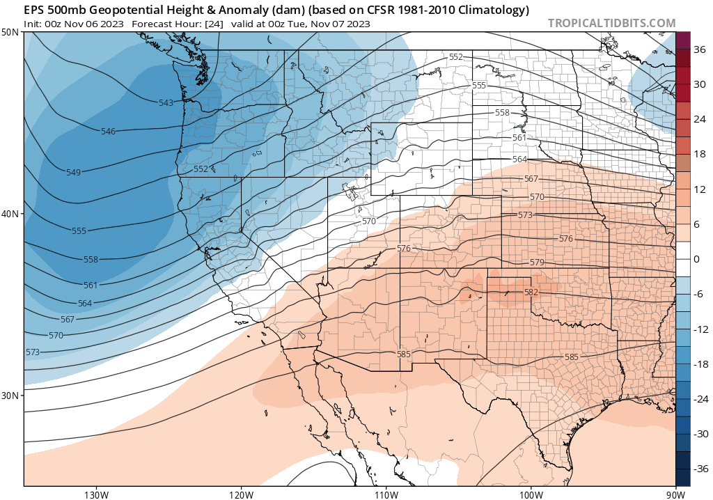
We talked briefly already about a storm complex lurking over the Pacific Northwest early in the week. That system will ultimately become a direct weather-maker for us Wednesday into Thursday as a positively tilted trough axis moves across the northern Rockies. Models are just now starting to come into better agreement on the overall progression of this trough — it was a bit touch-and-go the last few days. The main trough axis will enter Colorado Wednesday night and shear out, with a small piece of energy breaking off to the south across the Four Corners. Exactly how this trough shears out and what happens with the southern-branch of energy will determine the range of impacts for the Front Range.
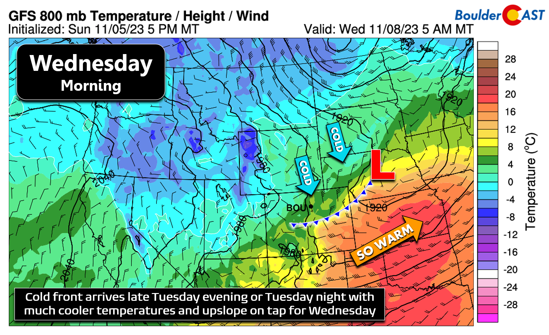
First and foremost, the main cold front with this trough is expected to reach our area sometime Tuesday evening or night. By Wednesday morning, the surface cold front will already be south of the Front Range, as shown in the 800mb temperature forecast below. This isn’t an Arctic front, that’s for sure — but we can definitely say goodbye to those 70s! As the front moves through early Wednesday, there may be a band of frontal- and/or jet-forced precipitation sagging southward across the area. Some models show this, some don’t. There probably will be some amount of rain/snow showers or banding accompanying the front early Wednesday, but the best chance of precipitation for us comes later on during the day and evening ahead.
Now in the first week of November, just about every storm system this time of year will be cold enough for snow across the lower elevations — whether that be all snow or a rain to snow transition. This storm system will probably be the latter as colder air gradually works into the Front Range throughout the day Wednesday. While initially it may be warm enough for some rain across the lower elevations Wednesday morning — things will be cooling during the day with everyone set to become cold enough for snow by afternoon and certainly by evening. High temperatures will be in the middle 40s at best on Wednesday morning, possibly colder if the clouds and upslope really get cranking early.
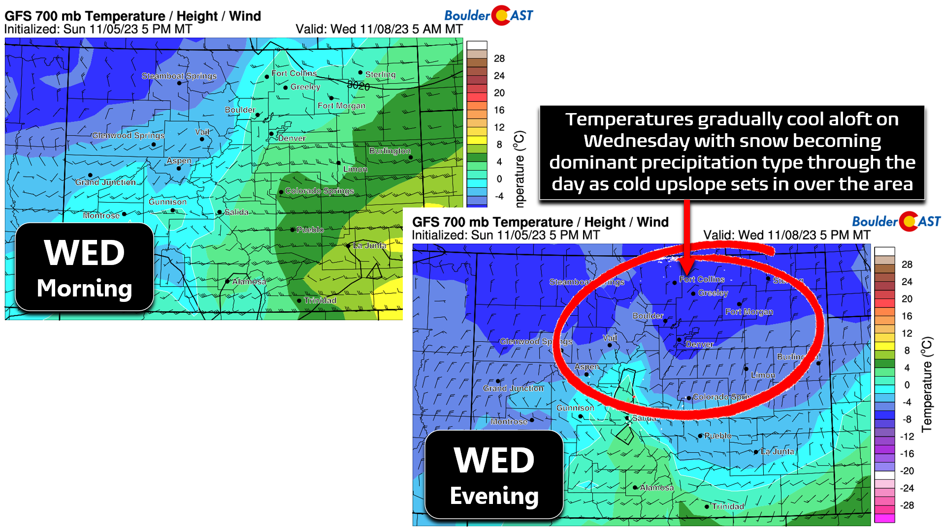
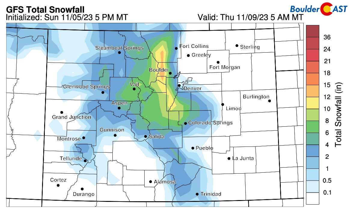
There is still an uncomfortable amount of model variation with this midweek system. The GFS solution has been trending wetter the last day or so, with many hours of deep upslope in the pipeline Wednesday afternoon into Wednesday night. Notice the 20+ MPH northeasterly flow above (bottom right panel). The GFS is currently latched onto a very topographically-forced precipitation forecast, with heavy snow indicated along the eastern slopes of the Continental Divide and in the Foothills, with next to nothing going down east of Interstate 25.
The Euro model has trended somewhat drier in recent runs, but its outlook isn’t really all that different from the GFS as it also has a strong emphasis on topographic upslope in and near the Foothills.
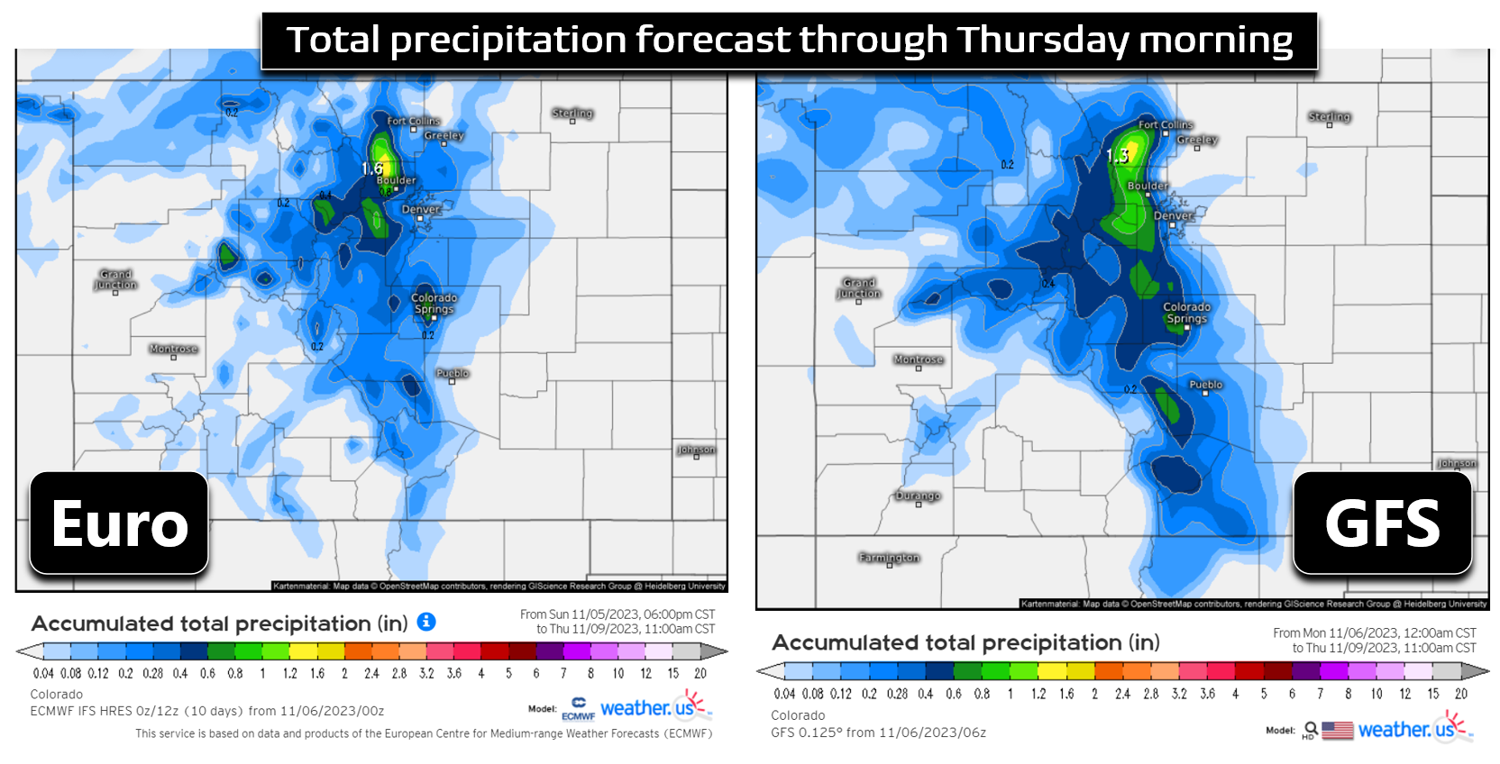
For now, things are too uncertain to make any definitive predictions for this storm system, though we do really like the look of the upslope some models are generating right here in the Front Range late Wednesday. If you are one of our many Foothills readers, stay aware for the potential for heavy snow — locally up to a foot may be possible above 7500 feet if things pan out as they are looking. The Denver Metro area also stands a good chance to pick up some rain and snow showers at least, but any accumulation is more uncertain across the lower elevations, especially for areas further away from the terrain. Our latest Snowfall Probabilities show a decent chance for low-end accumulation in the western portions of the Metro area, including Boulder which has a ~75% chance of 1+” of snow and a 50% chance at 4+”. Our best odds of seeing snow stick down low comes Wednesday evening and night when temperatures cool into the lower 30s.

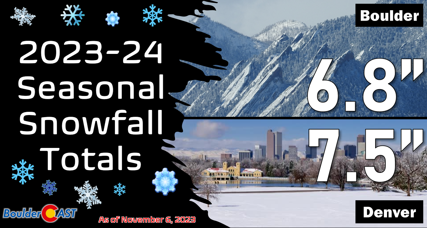
Could this be the storm that puts Boulder back in the seasonal snowfall lead over Denver? Probably but we’ll see….
Any lingering snow showers should wrap-up early Thursday morning with skies clearing through the day. Regardless of what happens with the more uncertain rain/snow aspect of the forecast, temperatures will be a lot more seasonal with highs dropping below normal the rest of the week into the 40s and 50s.
The Mountains won’t catch a ton of snow this week, as this will mostly be an upslope storm favoring areas east of the Continental Divide — some snow is better than no snow! The northern ski resorts could see 3-6″ or so Tuesday night into Wednesday night, with lesser amounts for the central and southern Mountains.

Stay tuned as we continue to track the next storm system arriving midweek! As always, follow us on Twitter and Facebook for more punctual weather updates, and be sure to subscribe to our email list for instant notifications when our broader storm updates like this one are published. Have a great week and let’s keep our fingers crossed for some much-needed moisture!
Get BoulderCAST updates delivered to your inbox:
Forecast Specifics:
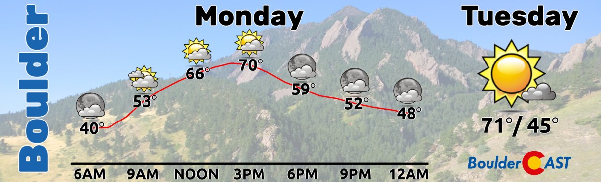
Monday: Partly cloudy and warm with some slight breeziness possible during the day. Highs reach the lower 70s on the Plains with upper 50s in the Foothills.
Tuesday: Mostly sunny, warm and breezy. Temperatures stay warming reaching the lower 70s again on the Plains with upper 50s in the Foothills.
Wednesday: Much colder following an overnight cold front with rain/snow showers possible during the day, turning to all snow by afternoon/evening. Best chance of accumulation will be in and near the Foothills Wednesday evening and night. Highs only in the low to middle 40s at best, even falling through the day into the middle 30s on the Plains with 20s in the Foothills.
Thursday: A few snowflakes may linger in the morning, but things should dry out quickly through the day with late-day sunshine expected. Highs in the middle 40s on the Plains with lower 30s in the Foothills.
Friday: Sunny and seasonal with temperatures reaching the low to middle 50s on the Plains with upper 30s in the Foothills.
DISCLAIMER: This weekly outlook forecast is created Monday morning and covers the entire upcoming week. Accuracy will decrease as the week progresses as this post is NOT updated. To receive daily updated forecasts from our team, among many other perks, subscribe to BoulderCAST Premium.
Go Premium, get all the perks.
Daily Forecast Updates
Get our daily forecast discussion every morning delivered to your inbox.
All Our Model Data
Access to all our Colorado-centric high-resolution weather model graphics. Seriously — every one!
Ski & Hiking Forecasts
6-day forecasts for all the Colorado ski resorts, plus more than 120 hiking trails, including every 14er.
Smoke Forecasts
Wildfire smoke concentration predictions up to 72 hours into the future.
Exclusive Content
Weekend outlooks every Thursday, bonus storm updates, historical data and much more!
No Advertisements
Enjoy ad-free viewing on the entire site.
Enjoy our content? Give it a share!


You must be logged in to post a comment.