
After a stunning weather-Wednesday, winter conditions are on the horizon again for Thursday as a big storm system moves into Colorado from the west. This one will bring much colder temperatures Thursday and widespread light to moderate snow to the area Thursday evening. Confidence is high that that most everyone will finally get their first accumulating snowfall of the season with this notably colder situation. We discuss the latest timing on the change-over to snow and provide our snowfall forecast map.
Premium Storm Update (11/3/22 7:00AM): Overnight model runs confirm the situation — the accumulating snow for all this evening remains on-track! We provide a brief update on the timing of the snow, how it will impact the evening commute, and discuss a few changes we’re making to our snowfall forecast amounts this morning. READ HERE
At a Glance:
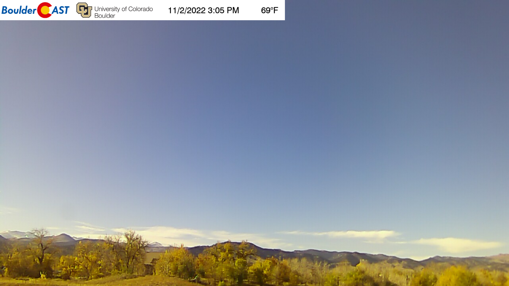
- Wednesday caps off the streak of warm weather for our area — yet another day flirting with 70 degrees
- A big and chilly storm will arrive Thursday with dropping temperatures during the day and winter weather expected by early evening
- Brief rain showers will change to all-snow Thursday late afternoon into the early evening with light snow lingering throughout Thursday night
- The overnight timing and colder temperatures should allow everyone to see some accumulating snow
- Snow totals of 1-3″ in the Boulder-Denver area, 3-7″ in the Foothills, and up to 10″ in the Mountains are expected
Be prepared for the winter ahead!
We discuss Boulder and Denver weather every single day on BoulderCAST Premium. Sign up today to get access to our daily forecast discussions every morning, complete six-day skiing and hiking forecasts powered by machine learning, access to all our Front Range specific weather models (including smoke forecasts), additional storm updates and much more!

Widespread accumulating snow expected Thursday evening
If you enjoy snow and your location happened to miss out on the snowflakes sticking last week, we have some good news to share! Another, colder weather system is bearing down on Colorado right now, though you’d hardly know it from the nearly 70-degree day we’re having on this Wednesday. Ah the good old “warm before the storm”. It’s nice to have an actual storm following the warm for once!
We’ve known about this wintry system for a while now — it was the keynote of our weekly outlook posted on Monday after all — but the details were fuzzy with poor overall model agreement on how a deepening trough across the West would evolve late this week. Today we will say the models are painting a clearer picture, and confidence has grown into full-blown expectation for accumulating snow up and down the Front Range Thursday evening and night.
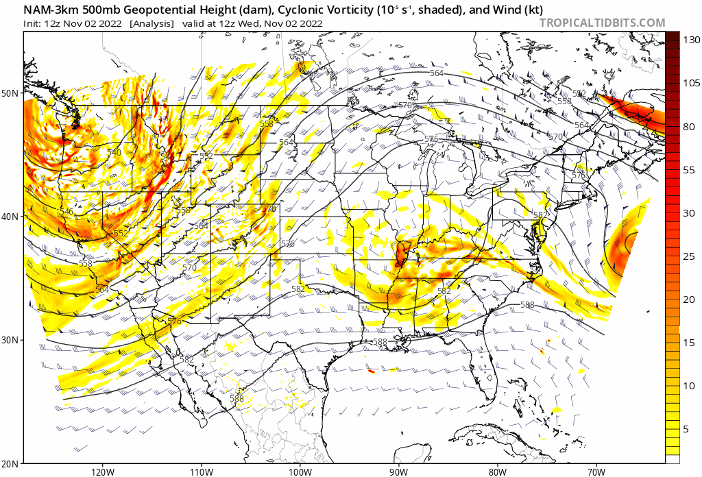
We’ll start by taking a look at the larger trough as a whole. As of Wednesday evening, the core is currently located over Oregon. The deep fetch of southwest flow out ahead of this storm is the reason for the warm weather we’ve had the last several days. This low pressure system will split into two distinct pieces of energy very soon. One gets whisked away by the jet stream into the prairies of central Canada bringing no impacts for Colorado. The other, fortunately stronger piece of energy digs southward into Arizona and New Mexico by Thursday night. This track would generally be considered too far south for much of an impact in our area, and that will indeed be the case this time as well. However, with a good chunk of the Denver Metro area having dodged accumulating snow so far this season, this weak storm will still be meaningful in that regard.
Unlike last week’s showing of snowflakes, this event will have notably colder temperatures wrapping in from parts of Canada — not only at the surface but also aloft. Though there may be a brief period of rain at the onset, but snow will be the primary precipitation type and it will be falling into a colder surface layer where it’s more likely to stick. Combined with the general timing of early evening Thursday into the overnight, having snow accumulate on the grassy surfaces and even the roadways will be much easier than it was just one week ago…
The initial cold front will arrive during the morning hours on Thursday making for a markedly colder day overall. The high temperature will occur in the morning hours, probably in the 40s for most of us. Temperatures will remain steady in the 40s and/or drop into the 30s as the front advances southward through the day.
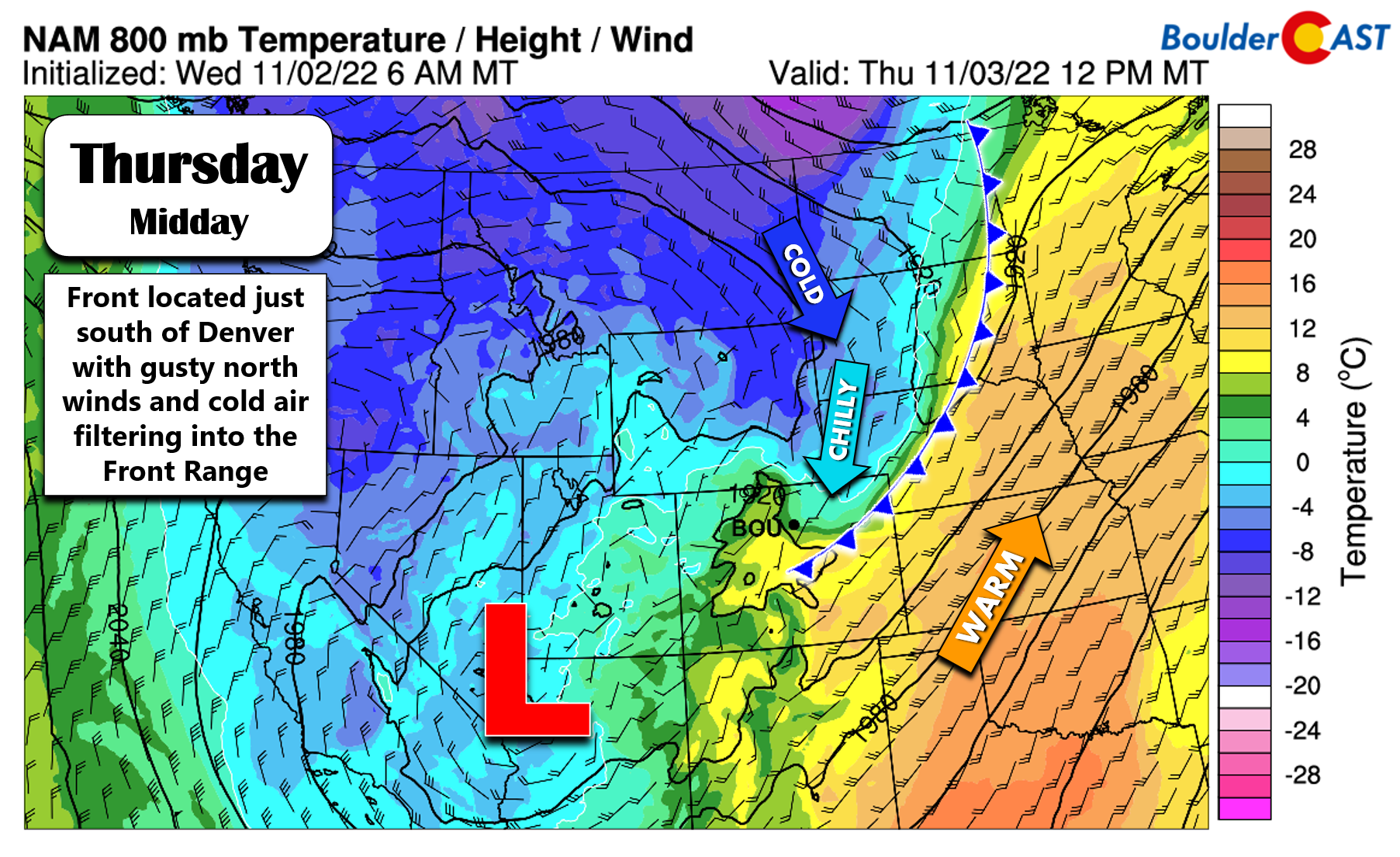
Cool and gusty northeasterly winds will usher in falling temperatures much of the day on Thursday. Those winds are indeed upslope for us, and as you can see below, the upslope will extend through a good chunk of the atmosphere — up to and beyond 10,000 feet elevation by Thursday evening. However, it’s important to note the upslope will be rather weak so it’s not a crucial player. In addition, frontal convergence will play a large part in generating snow Thursday evening. Think of this as clashing, sometimes even swirling winds which create rising air. The best frontal forcing appears to be lining up just east of Denver off towards Kansas. It MAY play a brief role in spawning a few moderate to heavy bursts of snow in our area Thursday evening.

The latest short-range model guidance (below) lines up with the global models’ depiction of the best frontal lift (above). That is, it’ll be just east of Denver and out across the Plains stretching towards the northeast corner of the state. A localized area there could see perhaps 3 to 6″ of snow as a result. Right now it doesn’t look like this setup will materialize over the Denver Metro, but it bears watching as the storm draws closer.

In terms of timing, rain/snow will develop late Thursday afternoon into the early evening for us. There may be a brief period of rain or rain/snow mix at the onset, but it should change-over to all snow for everyone by sunset. The best window for accumulation will occur from 6PM Thursday to 6AM Friday, with isolated pockets of moderate snow possible before midnight and just light upslope snow lingering into the early morning hours on Friday. Roadways could become slushy during this overnight period across the lower elevations and will become snow-covered in the Foothills.

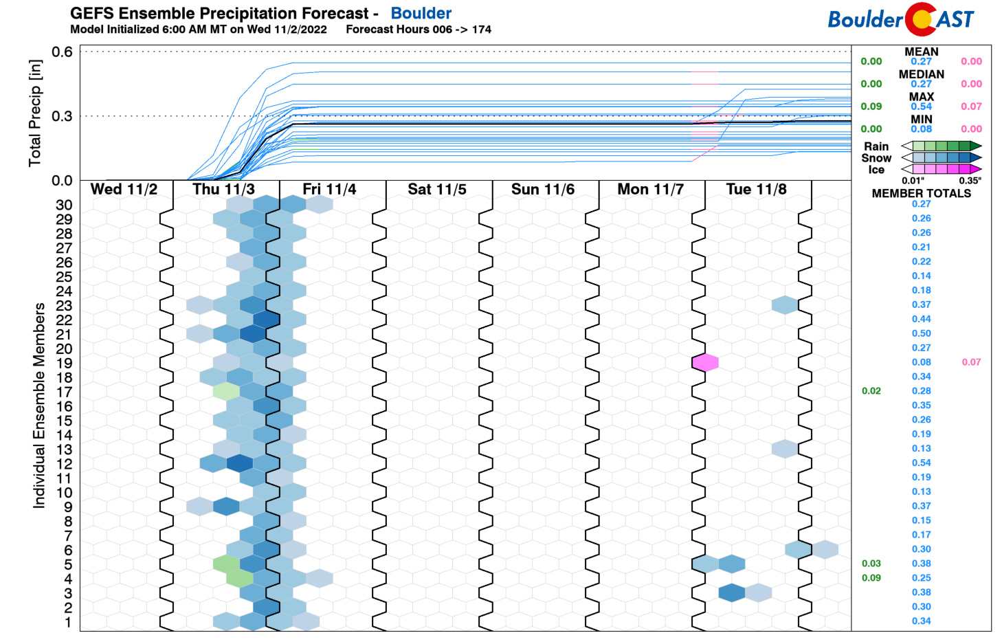
A look at the GFS ensemble precipitation forecast for Boulder shows a decent clustering between 0.2″ and 0.35″ of liquid from this event, with most of that falling as snow. The Canadian and European ensembles are right in this ballpark as well.
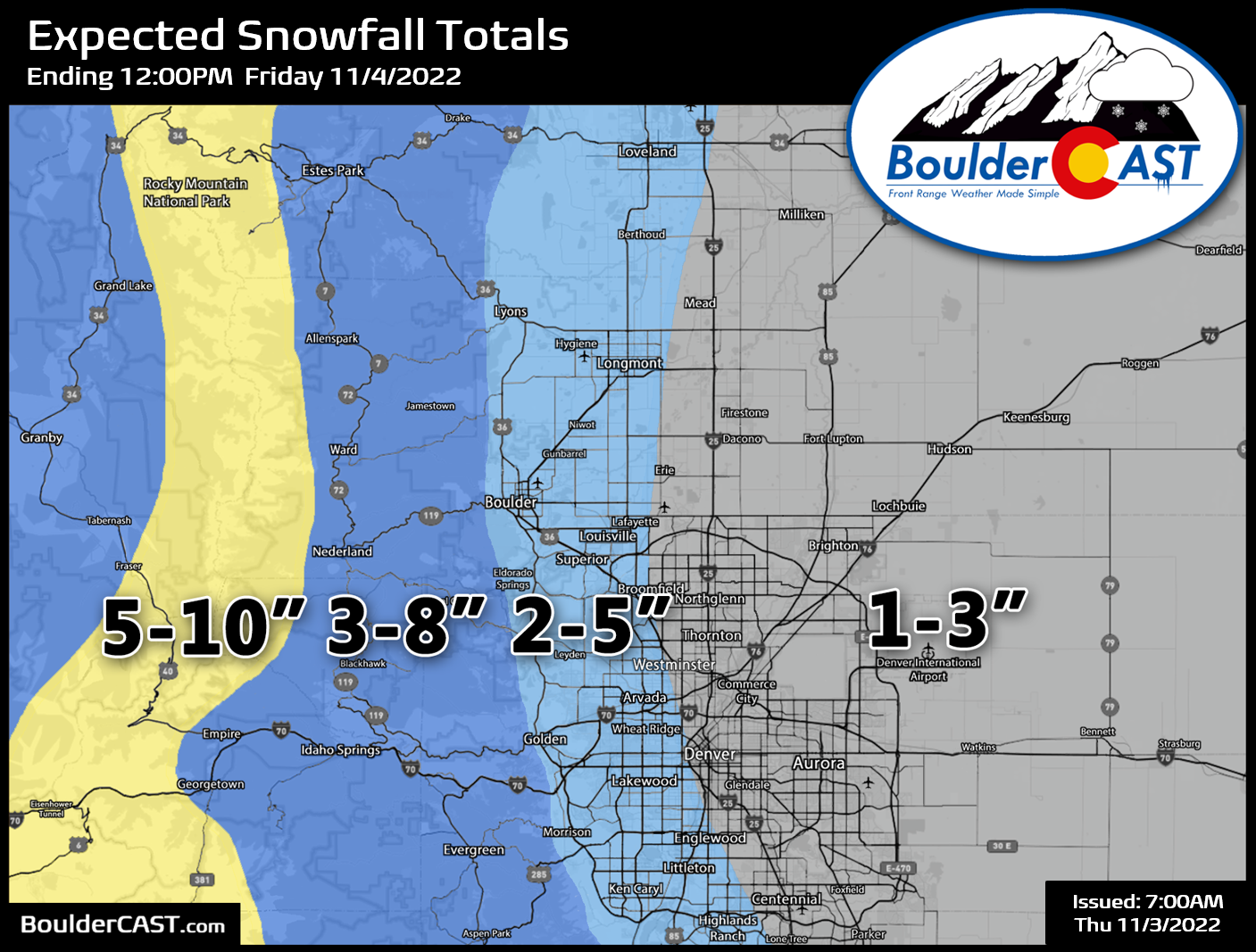
Our snowfall forecast map for this somewhat minor event is shown below. This covers all snow falling Thursday into Friday. As you can see, at this time we expected a broad brush of 1-3″ of snow for the Denver area and 2-5″ in the Boulder area. The Foothills can expect 3-8″ to fall — melting will be less of a concern there and snow ratios will be higher leading to fluffier snow. Areas above 10,000 feet can expect 5 to 10″. Snow could be particularly heavy Thursday afternoon in the Mountains with jet-forcing around — so do travel with caution!
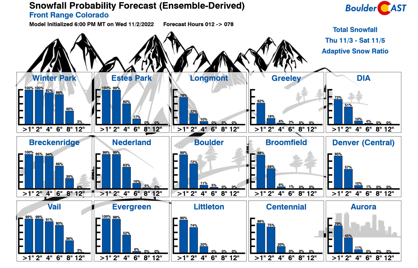
Finally, for the gamblers among us, here are the latest Snowfall Probabilities by city:
Winter Weather Advisories are posted for every single mountain range in Colorado above 10,000 feet for 4 to 10″ of snow in most cases. This storm will most heavily favor the San Juans which could see up to 20″!

Our fingers are crossed that everyone can finally check-off the elusive “first snow” box of the season by dawn Friday! We’ll continue to monitor the storm and if needed update our snowfall forecast map Thursday morning. Stay tuned, follow us on Facebook and Twitter for live updates and be sure to join our email list.
Get BoulderCAST updates delivered to your inbox:
Enjoy our content? Give it a share!


You must be logged in to post a comment.