Much-needed rain and snow fell across the Front Range on Thursday as a quick-moving storm raced across the state. Though temperatures remained entirely above freezing in Boulder and Denver, some embedded heavier pockets of snow allowed for minor accumulations to occur on the grass in spots, including at the official climate station in Boulder. This made for an interesting but somewhat underwhelming first snowfall of the season for many. We recap the storm, take a look at the snowfall totals across the region, announce the plethora of winners to our 2022 First Snowfall Contest, and look ahead to our next chance of snow.
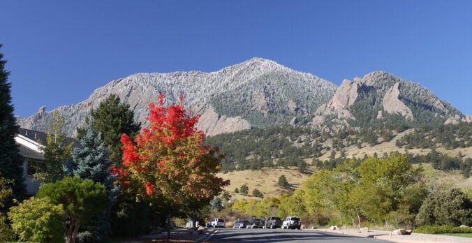
A dusting of wet snow!
Following a slight delay in the onset of the precipitation during the morning hours, Thursday’s rain and snow event largely played out as we had detailed in our final forecast update issued one day in advance. Rain moved in just before sunrise Thursday with temperatures around 40 degrees. Within an hour or two, evaporative cooling had dropped us into the middle 30s which helped things change-over to snow or a rain-snow mix in most locations across the Denver Metro area. Observations from our weather station indicate a change-over timing around 9AM, but it was probably a little earlier.
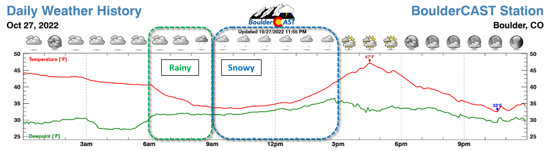
As the precipitation intensity waxed and waned Thursday morning, it seemed like we bounced around between rain and snow a lot. Even worse, a few stubbornly warmer locations remained as only rain (Longmont). Based on the results from a Twitter poll we posted during the event, about 75% of you saw at least a few snowflakes falling from the sky, with 25% receiving purely rain and 25% actually noting some slushy accumulation.
What's everyone seeing out there this morning? ❄️? 💦? Anything sticking at your location? #cowx
— BoulderCAST Weather (@BoulderCAST) October 27, 2022
Elevation played a bit more of a role than expected with this storm. A few hundred feet and the associated degree or two of temperature variability had a sizable impact on whether or not the snow stuck or just melted away faster than it was falling. The portions of the area which are slightly higher in elevation (and colder) picked a light dusting of snow, while those nearby but down in small topographic depressions may have had only rain. This was the case not just in Boulder, but across the entire Denver area. It definitely was an interesting day! This particular photo shows the lack of snow down low, but a winter wonderland just a few hundred feet up the Flatirons.
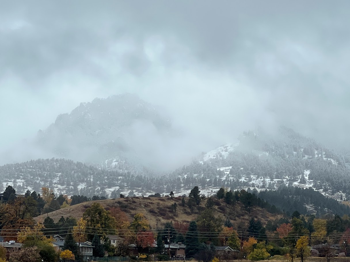
Photo credit: NWS-Boulder Twitter
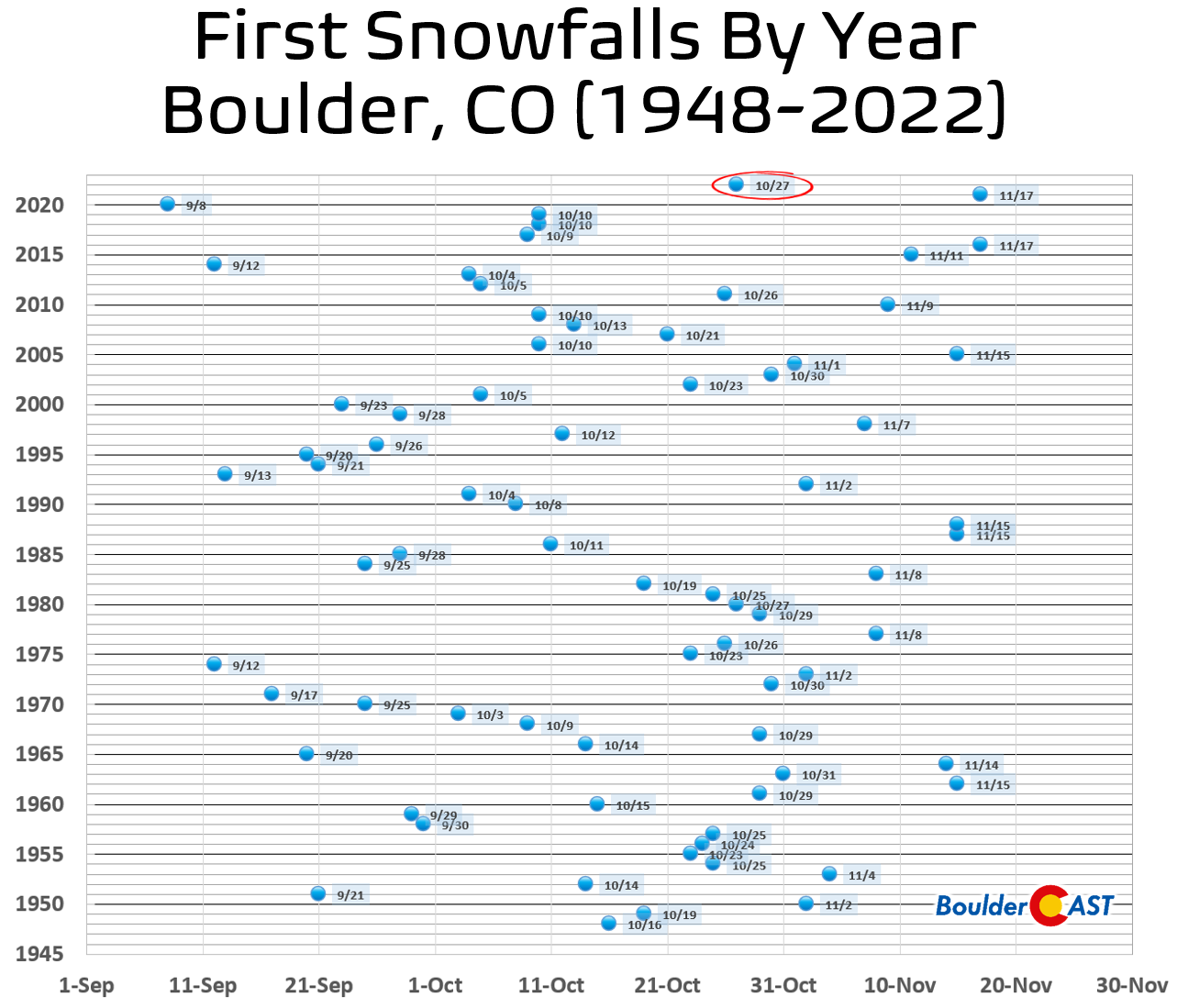
While most of Boulder may have not seen any snow stick, the official Boulder climate station did! Remember, it is located along South Broadway near 27th Way. The official observer reported 0.1″ from the event during the morning hours on Thursday making this the magical first snowfall of the season for the city, one that arrived about ten days later than the long-term normal date (October 18th).
Our snowfall forecast map for the event issued Wednesday afternoon is shown below with storm totals overlaid. Green numbers indicate our forecast verified to within 1″. Red did not. As you can see, anywhere from nada to 8″ of snow fell across the entire area with fairly decent forecast verification overall. The heaviest dumping of spring snow occurred in the Foothills of Jefferson and Boulder Counties. Generally the lower elevations saw 2″ or less of snow. Denver International Airport reported its second trace of snow of the season from this event, so sadly the Mile High City is still waiting anxiously for their first accumulating snow!
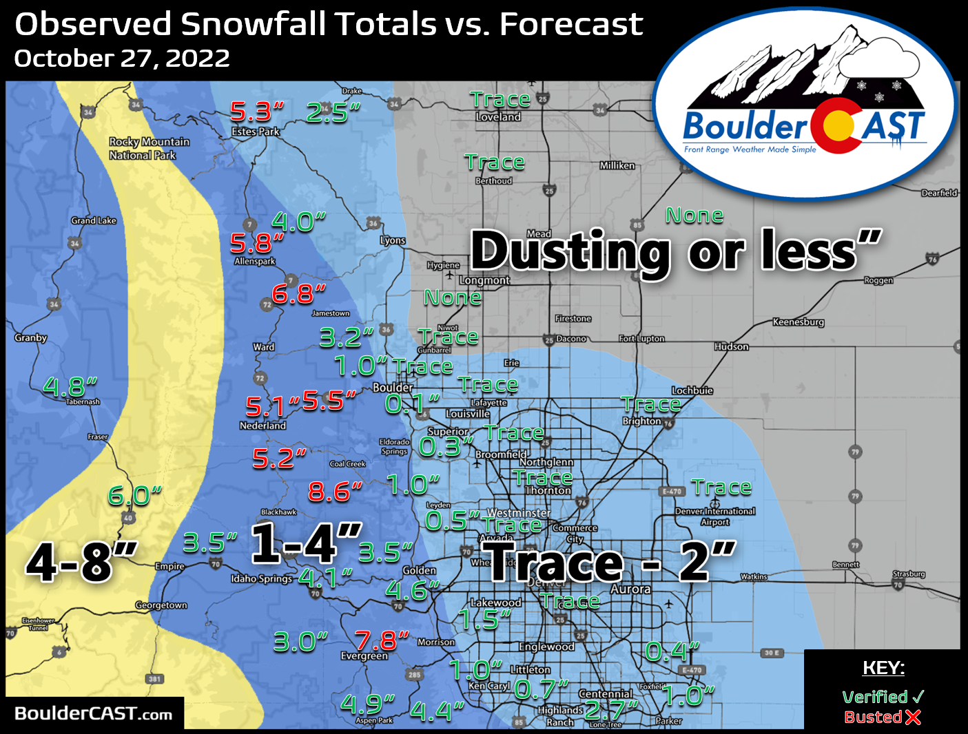
While this event wasn’t the most climatic way to get our first snow out of the way, it was an interesting one for sure. It’s unfortunate that some of Boulder didn’t actually see any accumulation on Thursday, and those that did had to pull out a tiny ruler and squint to get a meager measurement.
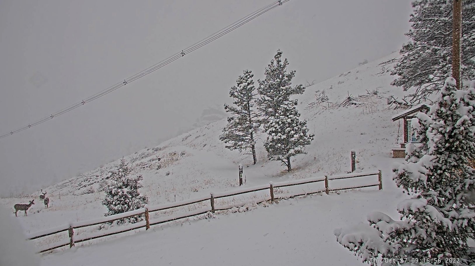
Deer “enjoying” the fresh snow at 7200 feet elevation just west of Boulder.
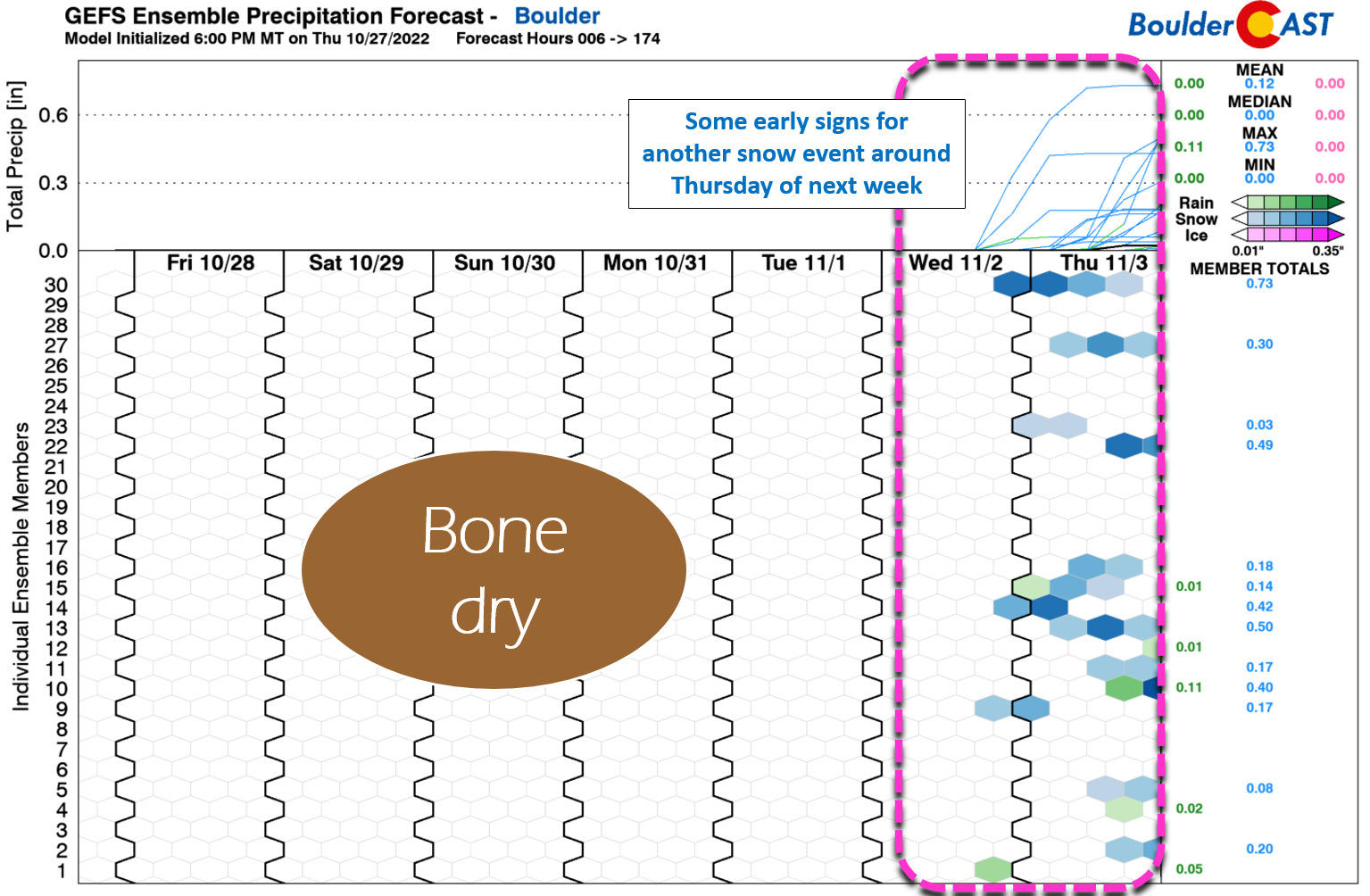
Let’s hope the second snowstorm of the season is a little more impressive that this one! Speaking of, we many not have to wait too long. We are seeing early signs in the models for a potential snow event around Thursday of next week. Enjoy the seasonal and bone-dry conditions until then…
BoulderCAST 2022 First Snowfall Contest Results
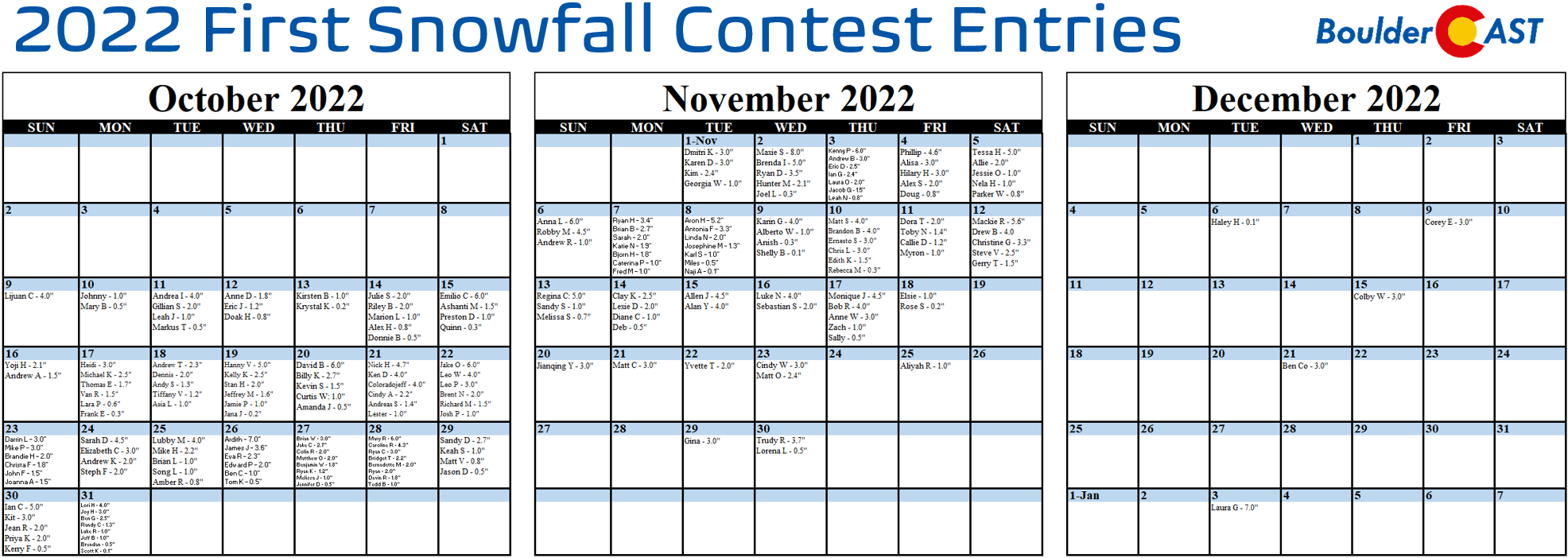
With Boulder’s first snow of the season officially in the bag, it’s time to announce the winners of our 8th Annual First Snowfall Contest. There were more than 250 entries this year which are summarized in the table below (click to enlarge).
A few notes about the predictions:
- Dates range from October 9th to January 3rd, the latter being latest guess we’ve ever had in eight years running this contest!
- Amounts range from 0.1 to 8.0 inches
- The median date of the guesses were October 30th. This is ten days later than climatology, perhaps a sign of public sentiment following last year’s historically late first snow
- The most popular days chosen were October 27th, 28th and 31st which were each selected eight times
- 88% of entries predict a first snow of 4.0 inches or less
- Due to our procrastination in ingesting the entries, about 20% of contestants have already been eliminated thanks to the boring month of October weather so far
The verification of Boulder’s first official snowfall was October 27, 2022 at an amount of 0.1″.
Congratulations to the winners detailed below. Prizes will be sent out via email in the coming days so do keep an eye on your inbox!
- 1st place: 12-month Premium subscription + $30 Amazon Gift Card
- Jennifer D (Oct 27 0.5″)
- 2nd place: 6-month Premium subscription + $10 Amazon Gift Card
- Melissa J (Oct 27 1.0″)
- Anyone who guessed within 1 day OR 0.1″ correct: 2-month Premium subscription
- Brian W (Oct 27 3.0″)
- Jake C (Oct 27 2.7″)
- Colin R (Oct 27 2.0″)
- Matthew O (Oct 27 2.0″)
- Benjamin W (Oct 27 1.8″)
- Ryan K (Oct 27 1.2″)
- Ardith (Oct 26)
- James J (Oct 26)
- Eva R (Oct 26)
- Edward P (Oct 26)
- Ben C (Oct 26) Hey that’s one of us!
- Tom K (Oct 26)
- Mary R (Oct 28)
- Caroline R (Oct 28)
- Ryan C (Oct 28)
- Bridget T (Oct 28)
- Bernadette M (Oct 28)
- Ryan (Oct 28)
- Devin R (Oct 28)
- Tedd B (Oct 28)
- Krystal K (0.2″)
- Jana J (0.2″)
- Scott K (0.1″)
- Naji A (0.1″)
- Shelby B (0.1″)
- Haley R (0.1″)
- All other entries: Virtual “pat on the back”
- More than 250 others
If you didn’t win, don’t worry. We’ll definitely host more weather-related contests periodically throughout the year, so do check back or subscribe.
Subscribe to receive email notifications for BoulderCAST updates:
We respect your privacy. You can unsubscribe at any time.
Help support our team of Front Range weather bloggers by joining BoulderCAST Premium. We talk Boulder and Denver weather every single day. Sign up now to get access to our daily forecast discussions each morning, complete six-day skiing and hiking forecasts powered by machine learning, first-class access to all our Colorado-centric high-resolution weather graphics, bonus storm updates and much more! Or not, we just appreciate your readership!

Spread the word, share Colorado weather:


You must be logged in to post a comment.