After a long, quiet stretch following last week’s snow squall, winter weather will return to the Front Range as a slow-moving but ultimately weak storm system impacts the area to end the work week. We discuss the long-duration of weak upslope about to unfold, the potential snowfall amounts across the area, and when travel will become slick.
Update (Thursday 3/7/24 7:00AM): We’ve now concerned that heavy snow the far eastern areas of Colorado on Thursday will reduce the amount of upslope/moisture that make it back westward into the Front Range. We’ve seen models trend downward in snow amounts slightly for our entire area, especially east of I-25. Thus, we’ve scaled back snow amounts slightly for the region. Please check our updated snowfall map, model forecast graphics, and storm impact timeline throughout this post. We talk about this last-minute shift and much more in Thursday morning’s Premium discussion HERE.
At a Glance
- Winter Weather Inbound: After a weeklong lull in our weather, an approaching winter storm will bring snowflakes and much colder temperatures to the Front Range Thursday into Friday
- Storm Details: The storm is being fueled by a slow-moving but broad trough, long-lasting but weak upslope, and some shortwave energy.
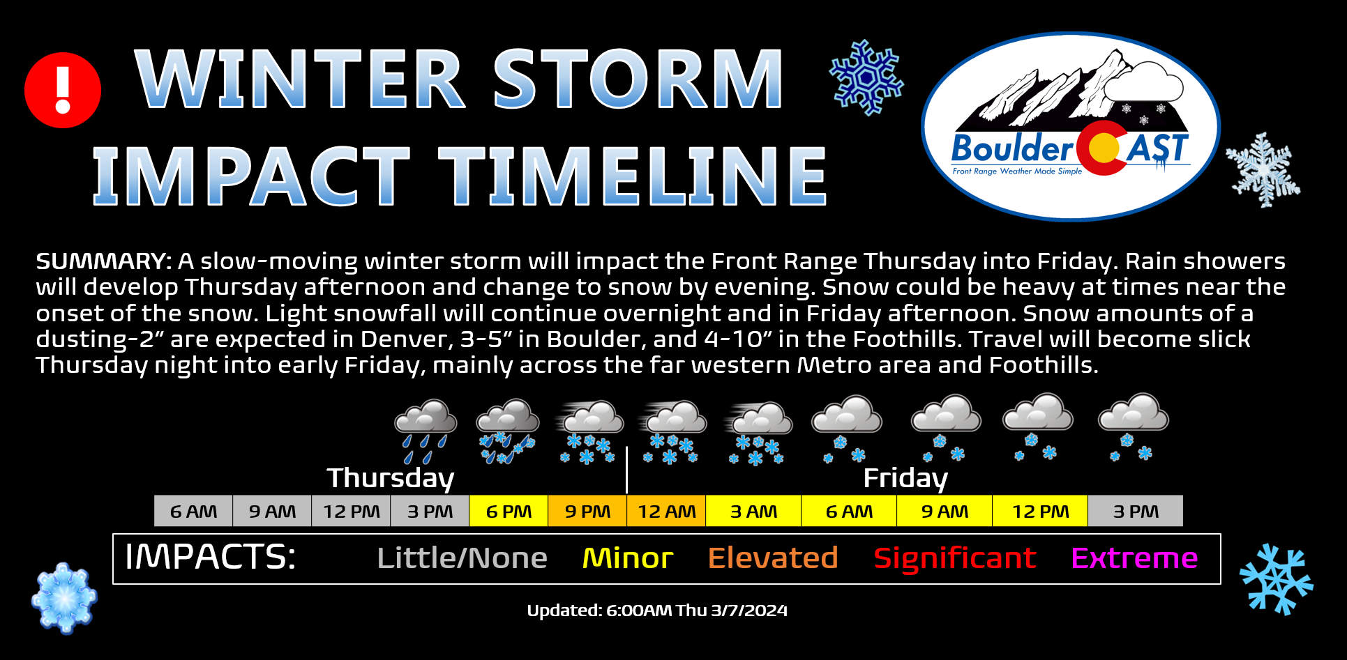
- Timing: Rain showers develop Thursday afternoon and change to all snow quickly Thursday evening. Snow may be heavy near the change-over. Light snow will continue Thursday night and linger into the day Friday before ending.
- Snowfall Forecast: Snow totals of 1-2″ in the heart of Denver, 3-5″ in Boulder, 4-10″ in the Foothills, and less than 1″ near DIA and areas northeast.
- Travel Impacts: Travel conditions will go downhill Thursday night into early Friday, mainly in the western Metro area and Foothills, with the Friday morning commute likely to be quite slick.
- Beautiful Weekend Ahead: The snow and cold clear out for the weekend with temperatures rebounding back into the 50s and even near 60° by Sunday.

Go Premium, get all the perks.
Daily Forecast Updates
Get our daily forecast discussion every morning delivered to your inbox.
All Our Model Data
Access to all our Colorado-centric high-resolution weather model graphics. Seriously — every one!
Ski & Hiking Forecasts
6-day forecasts for all the Colorado ski resorts, plus more than 120 hiking trails, including every 14er.
Smoke Forecasts
Wildfire smoke concentration predictions up to 72 hours into the future.
Exclusive Content
Weekend outlooks every Thursday, bonus storm updates, historical data and much more!
No Advertisements
Enjoy ad-free viewing on the entire site.
Snow returns to the Front Range Thursday evening!
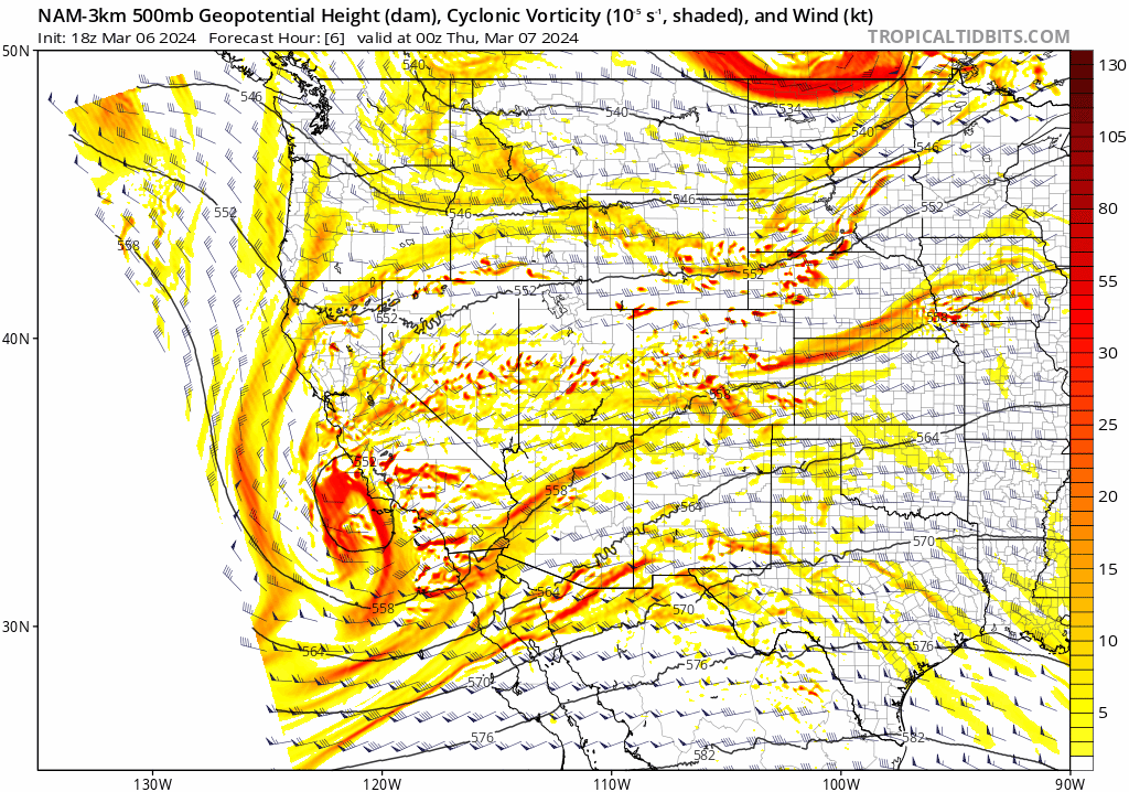
Our weather has been largely uneventful since the ferocious snow squall that blew through the entire Denver Metro area Tuesday of last week. However, that quiet stretch is about to come to an end! As we detailed in our weekly outlook issued on Monday, snow is on the way to the Front Range once again. The cause of the nasty weather to end the work week is a disorganized but broad trough which will move across the entire western United States in the days ahead. While this system lacks punch and overall organization, it is a slow-mover which will help spread the impacts from the weaker forcings out over 24 to 36 hours in our area. The trough will arrive into the Front Range Wednesday night (with a chance of rain showers for Boulder and Denver during the wee morning hours). The troughiness will linger over the state through all of Thursday and most of Friday, with northeast Colorado experiencing weak upslope flow, weak diffluence aloft, and several pulses of shortwave energy at times. The NAM 500mb vorticity forecast animation through Friday evening is shown below. Notice the immenseness of the trough and how it takes nearly the entire animation to move through our region.
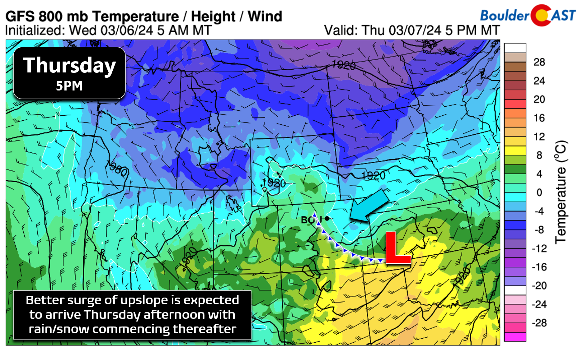
After the spotty rain showers overnight Wednesday night, things will dry out somewhat Thursday morning across the area before a better surge of easterly upslope moves in Thursday afternoon, as shown in the 800mb temperature/wind forecast below:
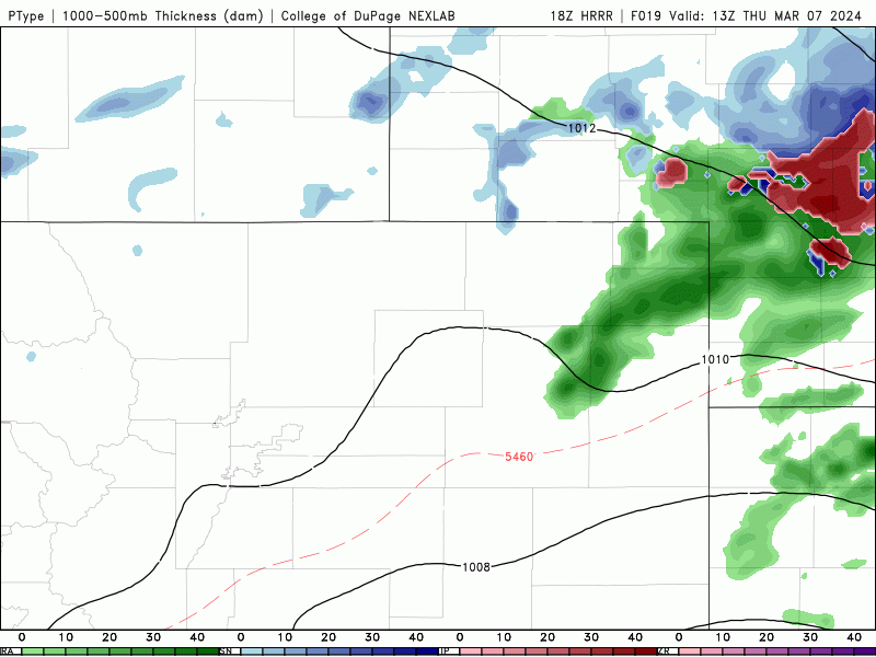
Scattered showers will break out Thursday afternoon and evening, with even the risk of some early springtime thunder mixed in (the best chance of that being south of Denver). Temperatures Thursday afternoon will be only in the mid to upper 30s across the lower elevations, too warm for snow so it’ll initially be rain down here with all snow in the higher Foothills. However, we will cool off quickly with rain changing to snow in short-order through the early evening hours on Thursday, earlier if the convective potential of the showers is fully-realized. The amount of cold air was initially a concern we had for this storm, but that fear has been quelled in recent model runs. Temperatures will dip well into the 20s Thursday night with snow lingering through the overnight. With such minimal large-scale forcing, upslope will be key for this event, acting to focus the most widespread and steady snowfall towards the western Metro area and Foothills, at least initially. After the first few hours of things, the instability will wane and upslope will reign king all the way through Friday afternoon, keeping light to snowfall going across most of the area. The simulated precipitation forecast animation from the short-range HRRR model is shown below.
Despite the weak nature of this incoming storm, its duration will help bolster the amount of much-needed moisture that dumps on us through Friday afternoon. Unfortunately there is still quite a bit of spread in the models regarding how much rain/snow we actually get. The GFS ensemble mean is around 0.4″ of moisture in Boulder (shown below), though there is notable spread right now from 0.3″ upwards to around 0.8″.
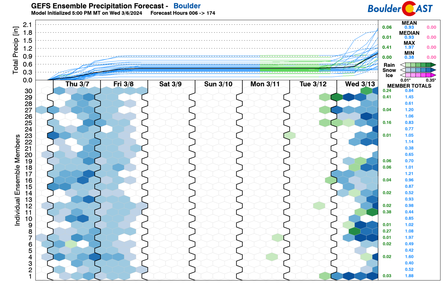
The short-range ensembles look similar, clustered mostly between 0.3 and 0.5″, but with a few boomers pushing up over 1″ (the below graphic is actually for Broomfield). Keep in mind, a small portion of this precipitation will be “lost” to rain near the onset of the event Thursday afternoon into early evening.
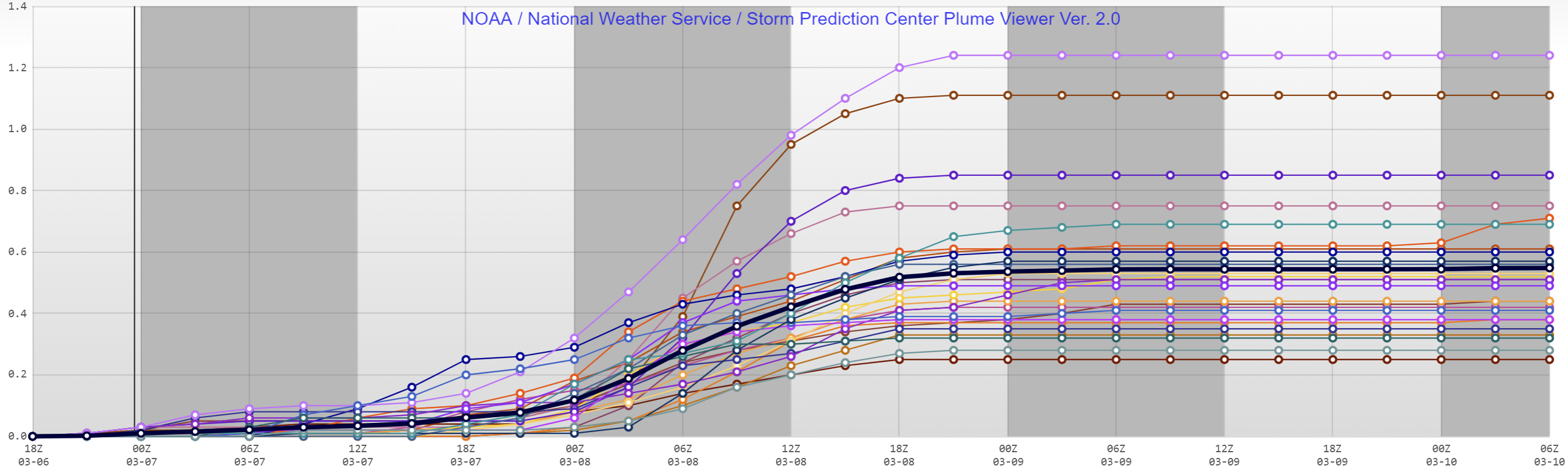
SREF (liquid) precipitation plume forecast for Broomfield. Each line is a different model ensemble model run.
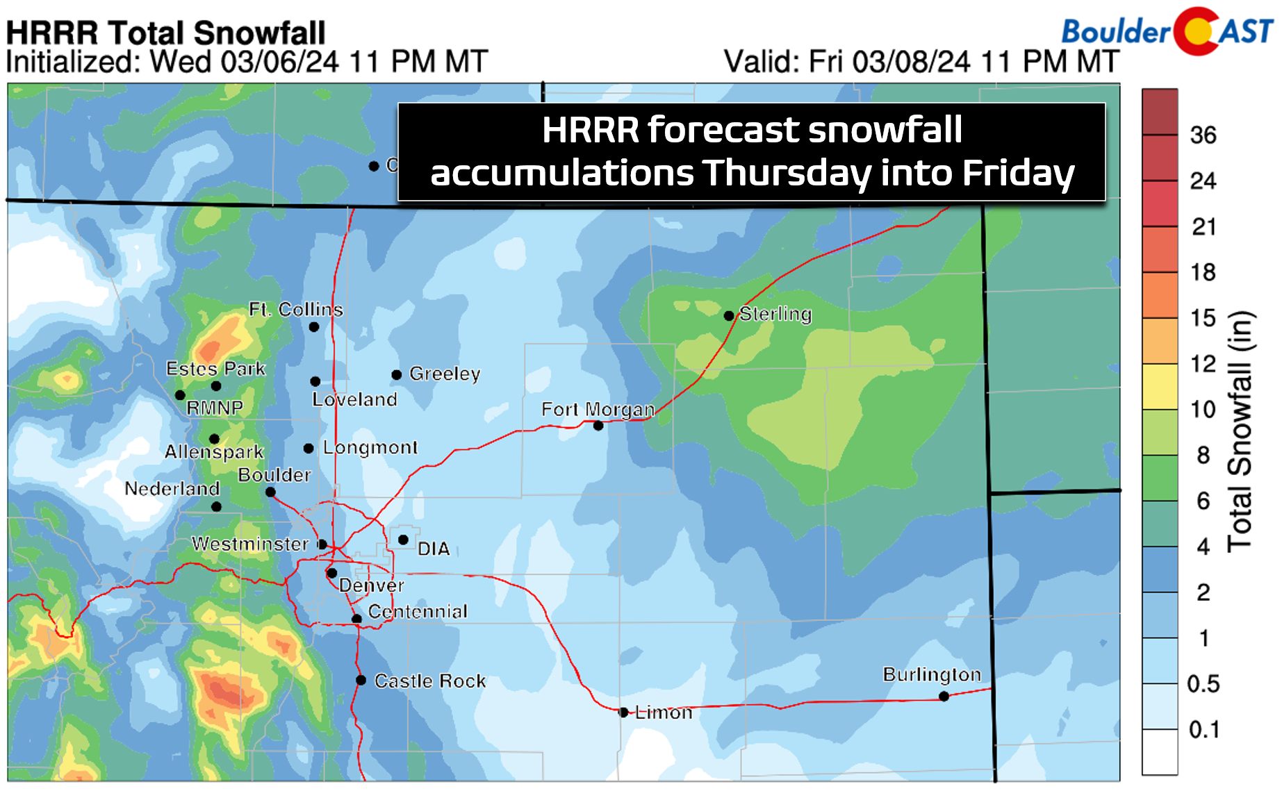
We do like the look of the HRRR model snowfall forecast for northeast Colorado. The heaviest snowfall will be in the Foothills where it will be colder (all snow, no rain, better snow ratios) and upslope will be most beneficial. Experience tells us that there should be a fairly decent snowfall gradient with this event, highest west and lowest east, and that is well represented in this model forecast.
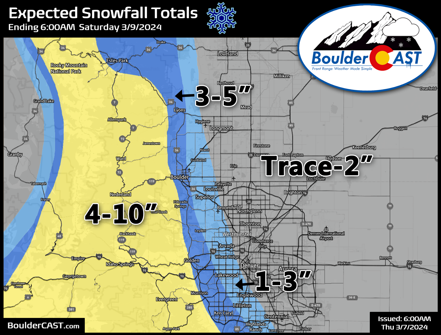
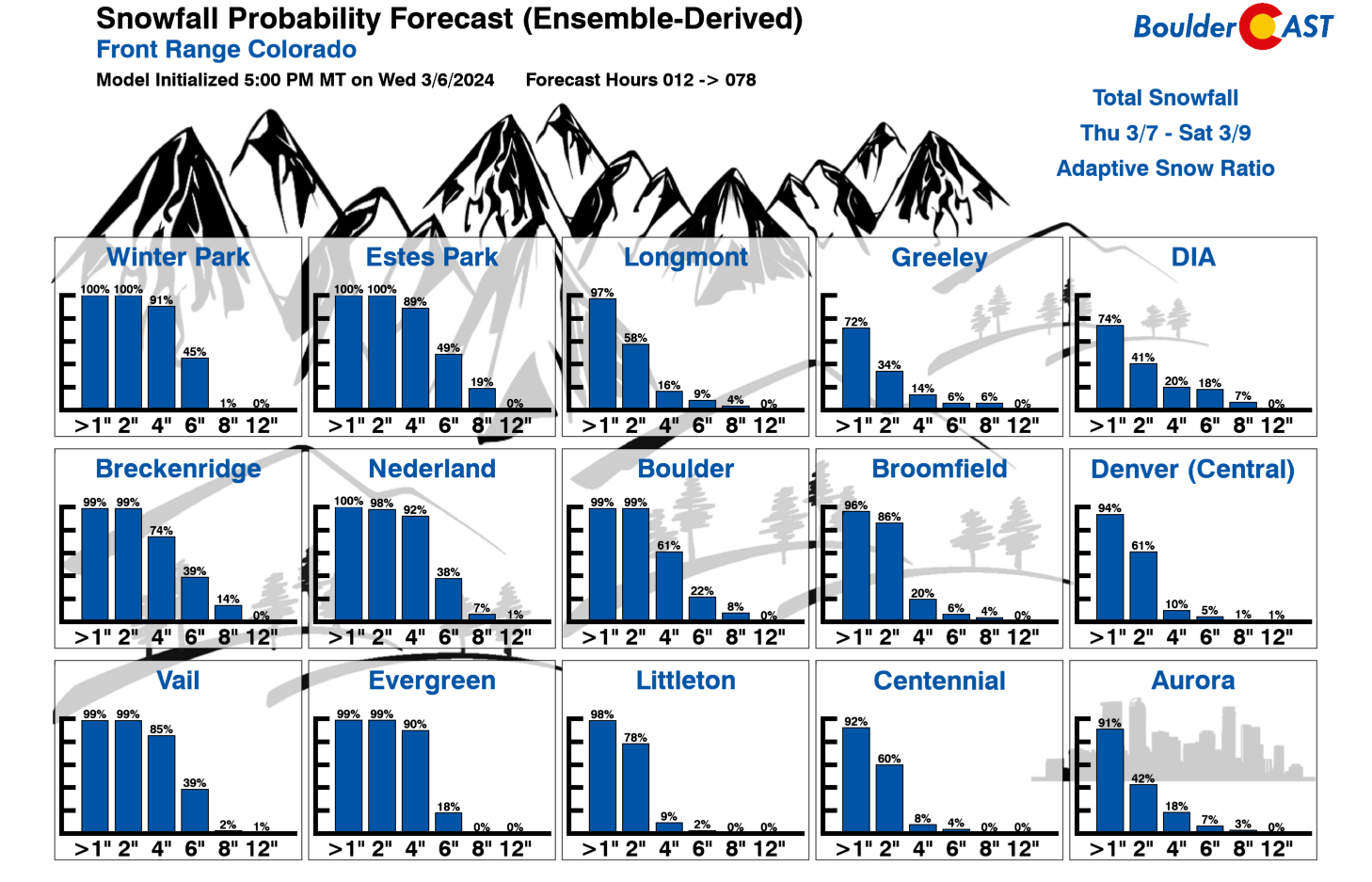
Given everything we’ve mentioned thus far, our snowfall forecast map for the event is shown below (Updated!). The core of Denver can expect 1-2″ of snow, with the chance for higher totals of 3-5″ in Boulder and the far western suburbs of Denver. DIA will see less than 1″, while the Foothills are set to receive a solid 4-10″ with locally higher amounts possible in spots that get in on the heaviest convective snow Thursday afternoon/evening.
Right now it appears the Thursday evening commute will be fine with mostly rain or a rain/snow mix across the Metro area. However, things will trend downhill Thursday evening and overnight with widespread snow ongoing and temperatures falling well below freezing, mainly across the far western Metro area including Boulder and the Foothills. The Friday morning commute could be slick from Boulder to Golden and areas in between! Plan a little extra time for your travel to and from your destination. Light snow will taper off through the day Friday, likely during the afternoon period.
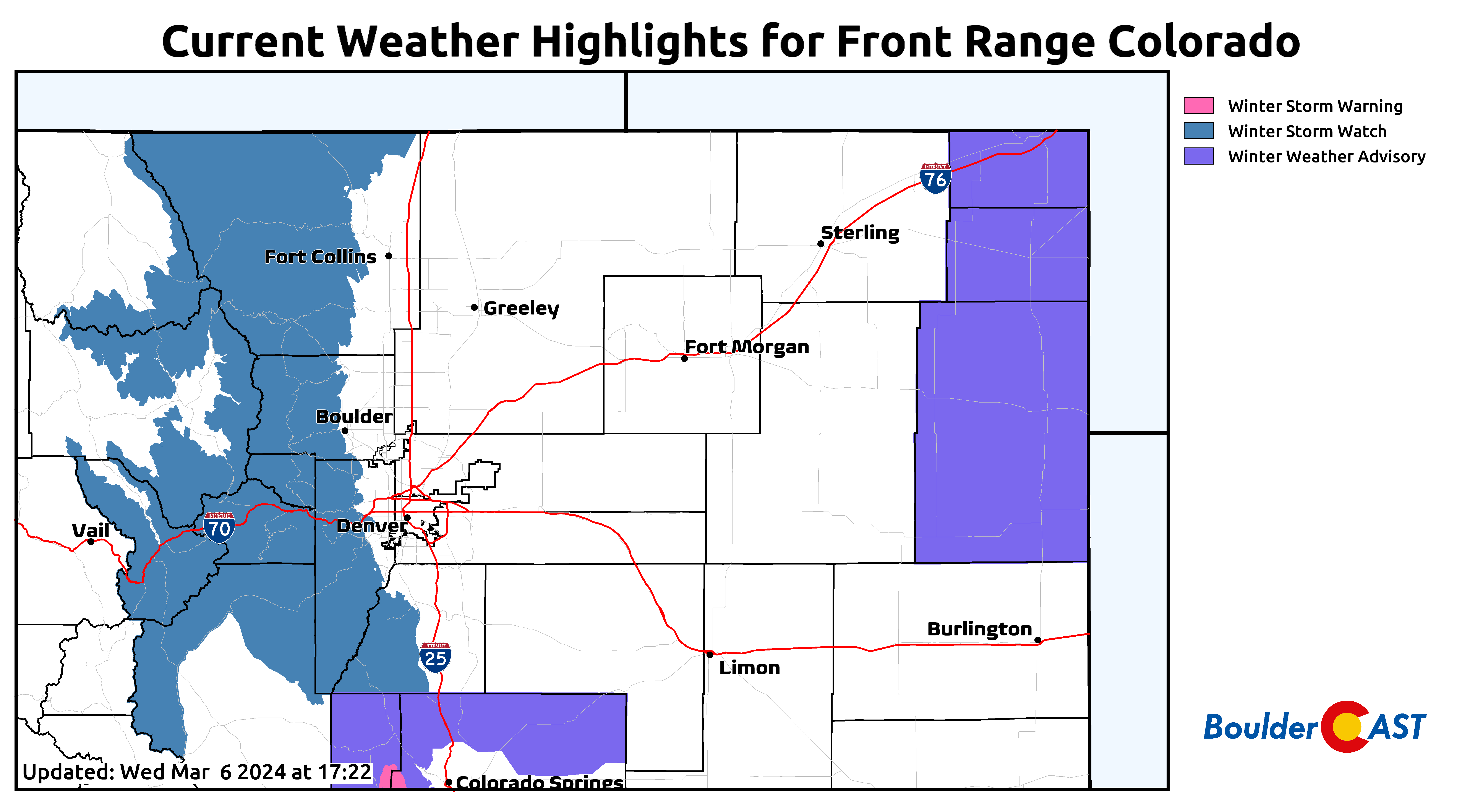
As of writing Wednesday evening, there is a Winter Storm Watch posted for the Foothills and Mountains where 5″ or more of heavy snow is highly likely. There’s nothing yet posted for the Denver Metro, but that may change before things get going on Thursday. Boulder in particular should be served with a Winter Weather Advisory we reckon.
A shortwave ridge will build across Colorado for the upcoming weekend which will bring dry weather and plentiful sunshine our way. Temperatures return to near 50° on Saturday and back close to 60° by Sunday! We must say that two gloomy days to end the work-week is a fair trade for the two beautiful weekend ones to follow.
Given the current uncertainty on the forecast (gamblers will enjoy our latest Snowfall Probabilities graphic below), particularly for the outside chance of higher snowfall amounts, we may update this post early on Thursday (updated!), including fine-tuning our snowfall forecast map if needed. Be sure to follow us on Twitter, Facebook, and Threads for additional updates as this winter storm approaches and unfolds. We’ll also have a final storm discussion posted Thursday morning on BoulderCAST Premium. As always, enjoy the snow!
Get BoulderCAST updates delivered to your inbox:
Go Premium, get all the perks.
Daily Forecast Updates
Get our daily forecast discussion every morning delivered to your inbox.
All Our Model Data
Access to all our Colorado-centric high-resolution weather model graphics. Seriously — every one!
Ski & Hiking Forecasts
6-day forecasts for all the Colorado ski resorts, plus more than 120 hiking trails, including every 14er.
Smoke Forecasts
Wildfire smoke concentration predictions up to 72 hours into the future.
Exclusive Content
Weekend outlooks every Thursday, bonus storm updates, historical data and much more!
No Advertisements
Enjoy ad-free viewing on the entire site.
Enjoy our content? Help us out and give it a share:


You must be logged in to post a comment.