Mother Nature will mostly offer up seasonal temperatures and dry conditions to the Denver Metro area through midweek. There will be a few disturbances Tuesday and Wednesday embedded in the southwest flow aloft, but these will mainly impact the higher terrain. However, we are watching a late-week cold front which will usher in colder temperatures, upslope flow and likely produce widespread accumulating snow for most of the Front Range. Let’s take a look!
This week’s highlights include:
- Seasonal temperatures into midweek: Our high temperatures remain fairly steady in the upper 40s to middle 50s through Thursday
- Rain showers possible Tuesday & Wednesday late-day periods: A weak disturbance will warrant a low-end chance of snow/rain both Tuesday and Wednesday evenings, mainly in the Mountains.
- Chillier with accumulating snow developing by late-week: Passing upper-level disturbances with post-frontal chilly upslope will bring a good chance of snow late Thursday through Friday with accumulation likely for the Front Range, highest in and near the Foothills
DISCLAIMER: This weekly outlook forecast is created Monday morning and covers the entire upcoming week. Accuracy will decrease as the week progresses as this post is NOT updated. To receive daily updated forecasts from our team, among many other perks, subscribe to BoulderCAST Premium.

Go Premium, get all the perks.
Daily Forecast Updates
Get our daily forecast discussion every morning delivered to your inbox.
All Our Model Data
Access to all our Colorado-centric high-resolution weather model graphics. Seriously — every one!
Ski & Hiking Forecasts
6-day forecasts for all the Colorado ski resorts, plus more than 120 hiking trails, including every 14er.
Smoke Forecasts
Wildfire smoke concentration predictions up to 72 hours into the future.
Exclusive Content
Weekend outlooks every Thursday, bonus storm updates, historical data and much more!
No Advertisements
Enjoy ad-free viewing on the entire site.
Mild temperatures with limited rain/show chances into midweek
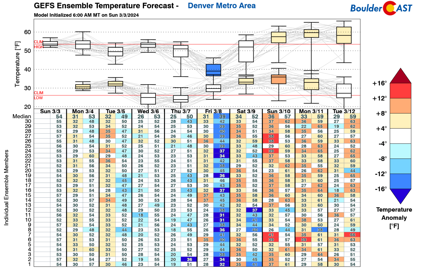
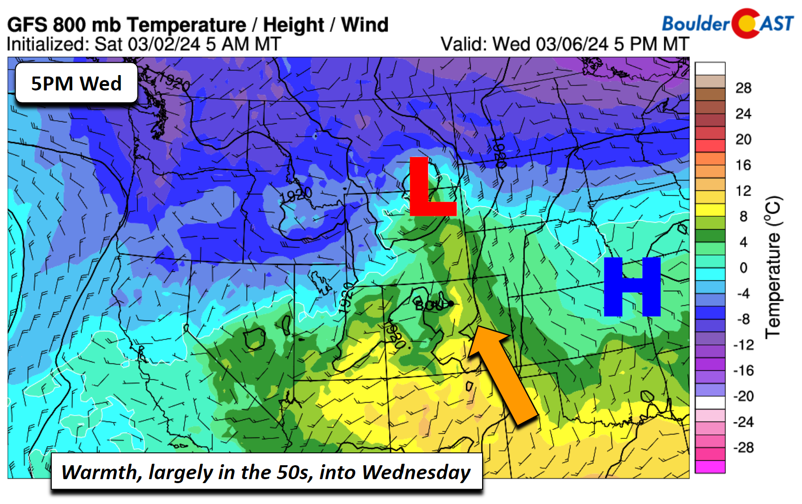
We begin with a general look at our weather for the days ahead. Our week will start off on the mild side, but not by much, with temperatures hovering a few degrees on either side of normal. The GEFS temperature trend this week shows that highs will largely stay in the 50s, though some upper 40s are possible as well. A cooling trend is favored with 30s by week’s end following a cold frontal passage. Wednesday should be our warmest day with temperatures pushing well into the 50s.
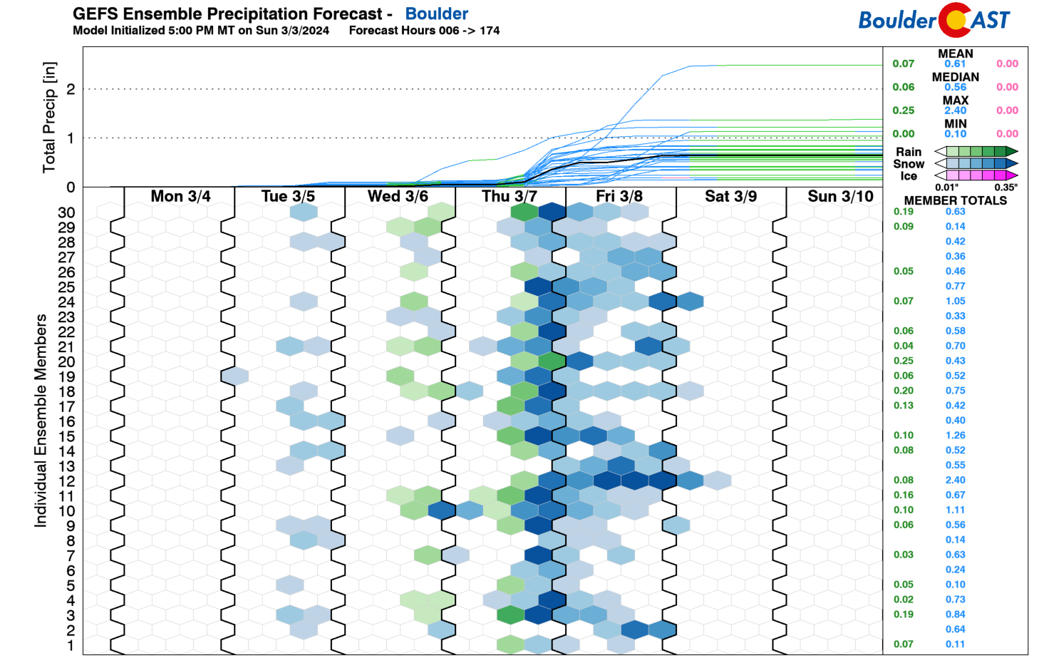
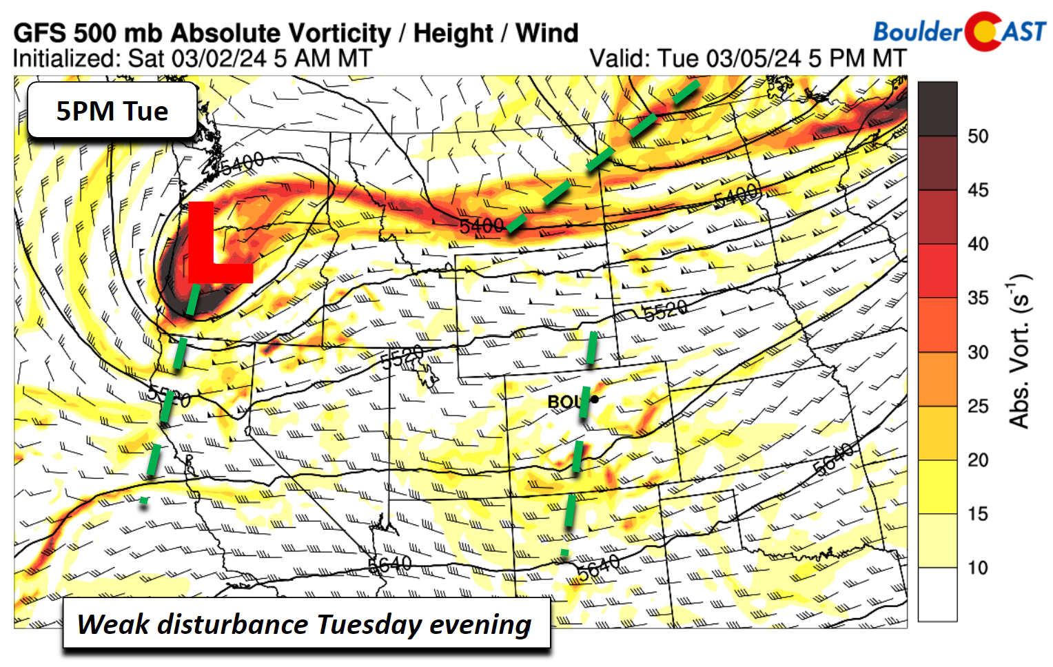
As for precipitation chances, there are low-end odds of late-day showers both Tuesday and Wednesday. However, the better threat for rain/snow this week will be later on Thursday into Friday, which we’ll cover towards the end of this post.
A trough over western Canada and the Pacific Northwest will bring broad west-southwest flow to start our week. Weak energy and some moisture around the base of this trough will produce periods of showers across northern and northwestern parts of Colorado these next few days, but this will largely spare the Denver Metro area.
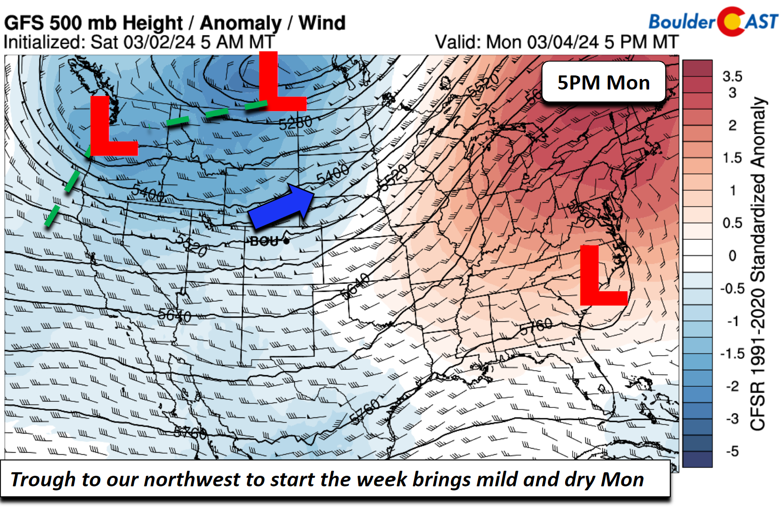
High pressure over eastern Colorado on Monday behind will favor a slightly cooler day in the upper 40s for the Plains. However, as the week progresses, the center of the high will shift eastward towards the Midwest. That will allow a better southerly return flow to aid in milder temperatures by the time we get to Wednesday — the day that is likely to be our warmest of the week.
Mixed in between the mild weather will be a few very minor disturbances moving through the area Tuesday and Wednesday — the one on Tuesday is somewhat more noticeable than Wednesday. These disturbances combined with daytime heating will bring chances for showers across the state. With limited to non-existent upslope, our chances in the Metro area will be very minor, generally 10% or less. Given the milder temperatures across the Metro area, any showers we see would mainly be in the form of rain across the lower elevations both Tuesday and Wednesday, though a few snowflakes could mix in based on the timing.
Chillier with accumulating snow likely late in the week
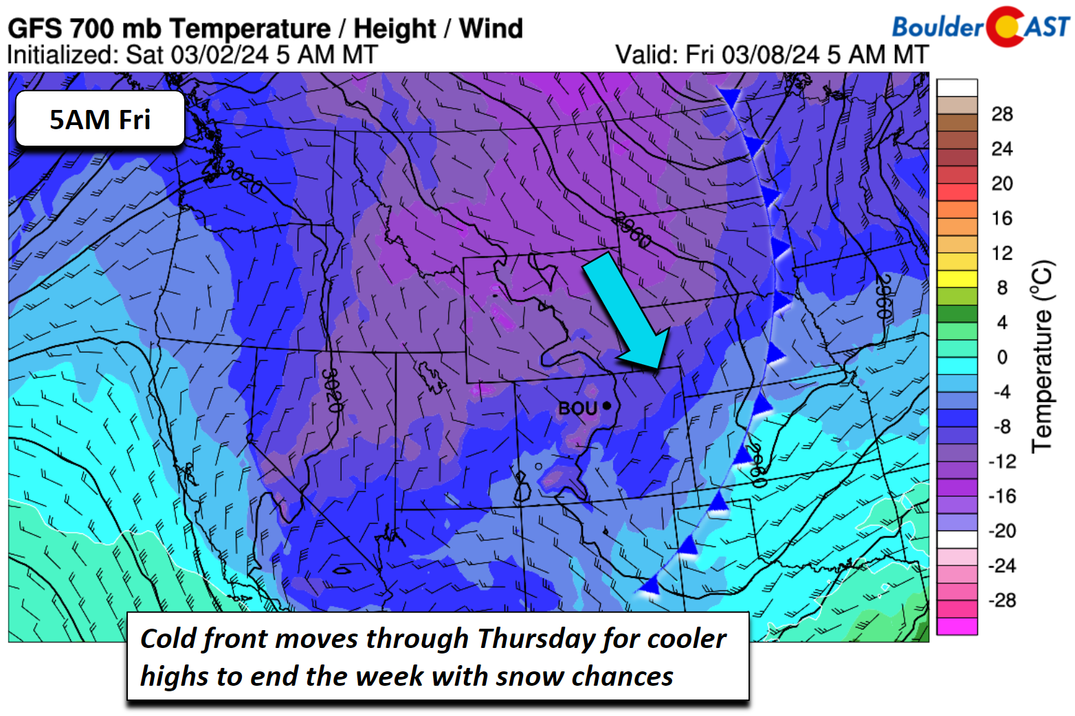
A trend toward below normal high temperatures appears favored by the tail-end of the week, along with better snow chances. On a larger scale, several shortwaves will exist over the western United States Thursday and eventually track eastward into Saturday. Most of these shortwaves will indirectly impact us. The northern one over North Dakota will stay to our north and the one near Arizona should stay to our south. That means we’ll likely be in between most of this energy, but we probably won’t miss out on it entirely.
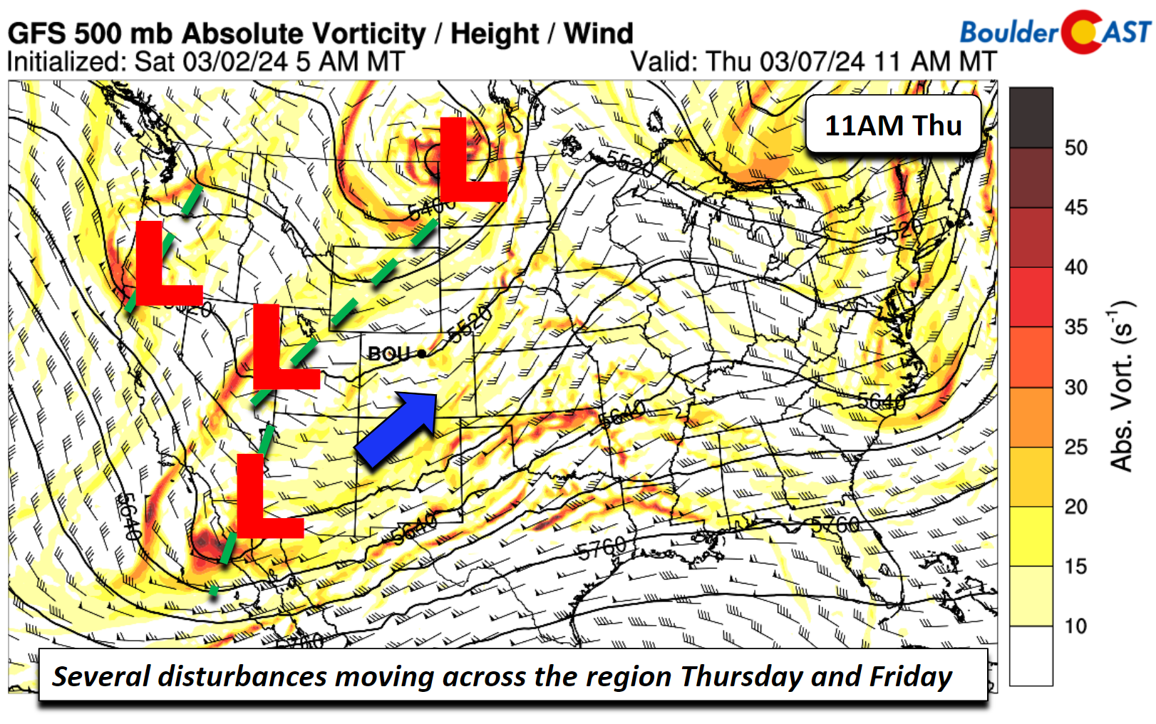
The more interesting aspect of the late week period is the cold front which will move through Wednesday night into Thursday and continue to bring in chillier air through Friday with persistent northeasterly upslope flow developing across Boulder and Denver. With the upslope more favored and some energy sliding across, most guidance is leaning towards decent snow potential along the Foothills and Denver Metro area late Thursday and through Friday. Being this far out, along with the lack of strong energy seen moving through, we have limited confidence thus far, but we are watching a potential weak low forming east of Colorado Friday, which warrants that snow potential.
The highest snow amounts are going to be in the Mountains, especially from Aspen to Steamboat, where totals will be over a foot in places!
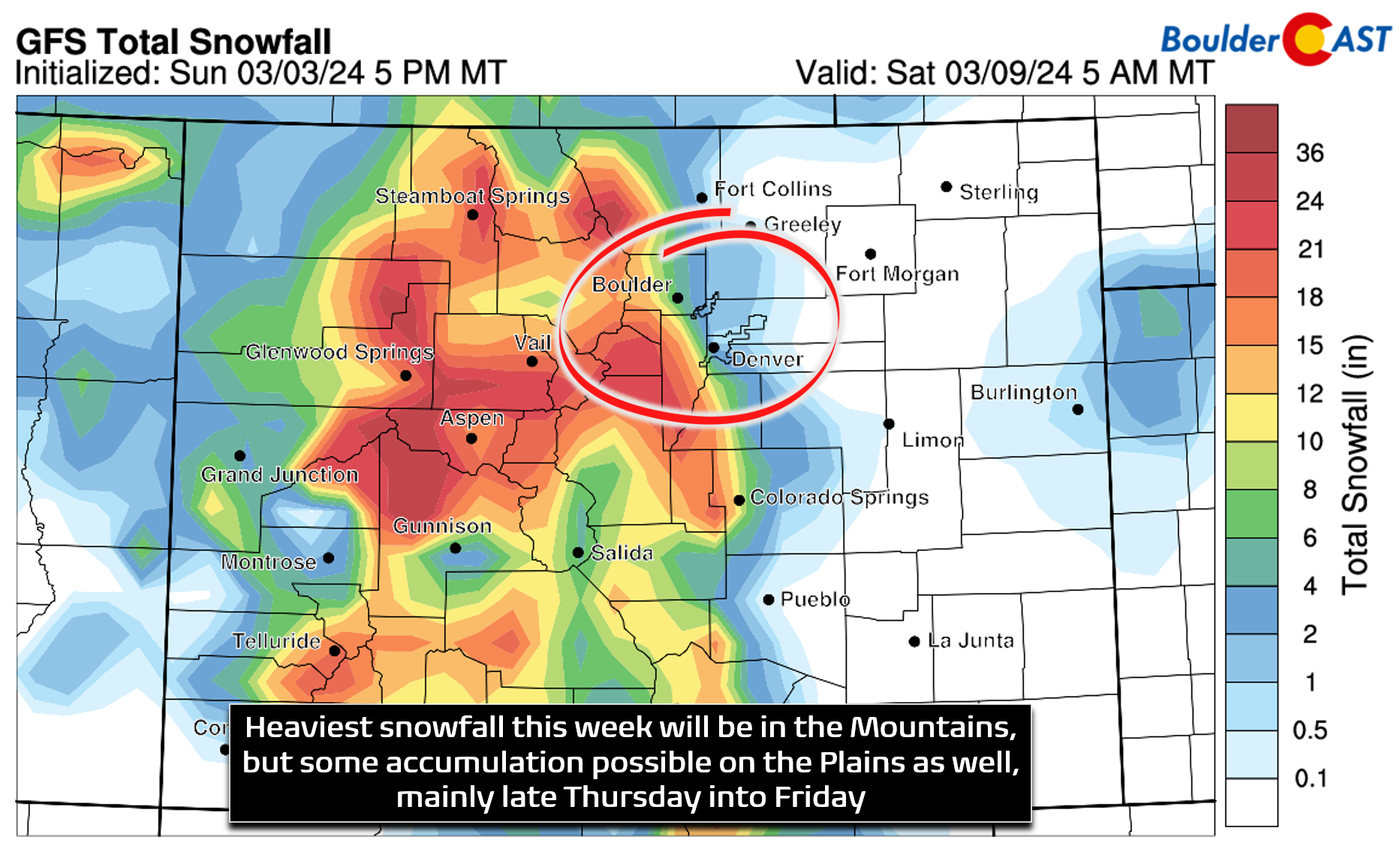
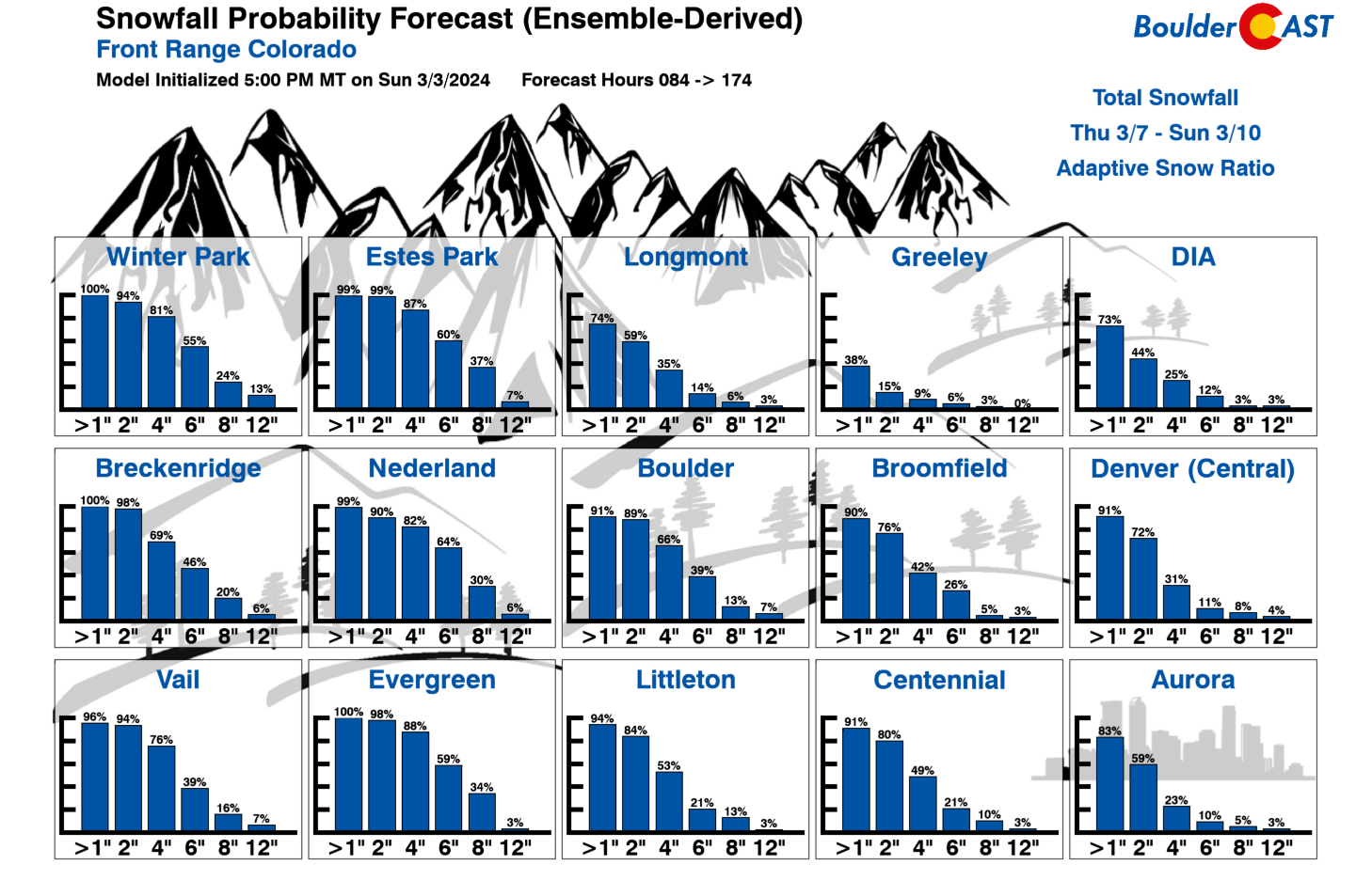
As for the Boulder and Denver area, things are less clear-cut. We’ll need to monitor the situation as the week evolves, but current model trends would suggest a strong likelihood of light to moderate snowfall accumulations up and down the Front Range, with a focus west and southwest of Denver into the Foothills and Palmer Divide where persistent upslope will do its best work. The latest ensemble guidance pings this as a 1-4″ snow event for Denver, with more like 3-7″ in Boulder.
Overall, this week will remain fairly seasonal and at times unsettled, but the biggest thing to watch out for is the developing late-week snow chance Thursday into Friday. Stay tuned and subscribe for updates to follow.
Get BoulderCAST updates delivered to your inbox:
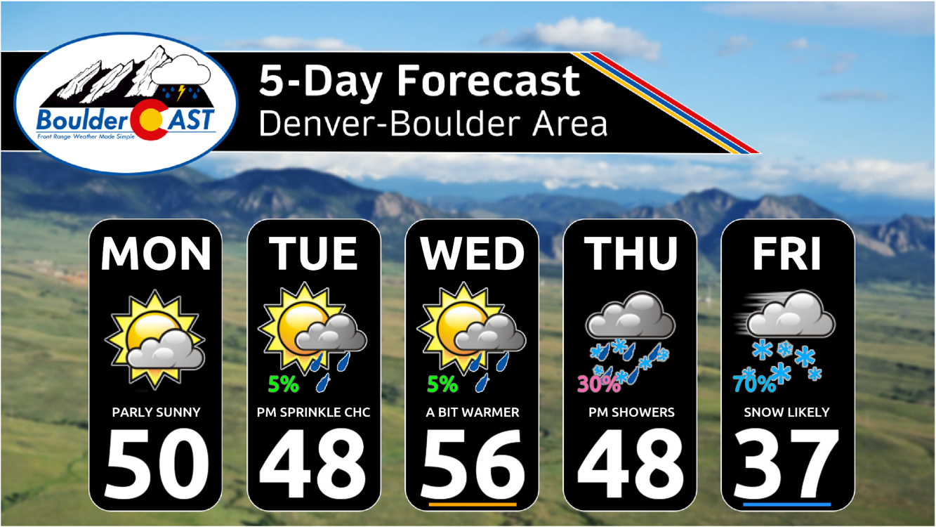
Forecast Specifics:
Monday: Partly cloudy and cool with highs around 50 degrees for the Plains and upper 30s in the Foothills.
Tuesday: Partly to mostly cloudy and cool with a slightly chance of late-day rain showers. Highs in the upper 40s on the Plains with middle 30s in the Foothills.
Wednesday:Partly to mostly cloudy but warmer with a slightly chance of late-day rain showers. Highs in the middle 50s on the Plains with lower 30s in the Foothills.
Thursday: Increasing clouds with a chance of late-day rain/snow changing to all snow Thursday night. Highs in the upper 40s for the Plains and middle 30s in the Foothills.
Friday: Overcast and drab with a chance of snow during the day, especially west and southwest of Denver where upslope will be most efficient. High temperatures will be colder in the 30s across the Plains with 20s in the Foothills.
Weekend: The weekend ahead will be dry and seasonal with high temperatures in the 50s. Hooray!
DISCLAIMER: This weekly outlook forecast is created Monday morning and covers the entire upcoming week. Accuracy will decrease as the week progresses as this post is NOT updated. To receive daily updated forecasts from our team, among many other perks, subscribe to BoulderCAST Premium.
Go Premium, get all the perks.
Daily Forecast Updates
Get our daily forecast discussion every morning delivered to your inbox.
All Our Model Data
Access to all our Colorado-centric high-resolution weather model graphics. Seriously — every one!
Ski & Hiking Forecasts
6-day forecasts for all the Colorado ski resorts, plus more than 120 hiking trails, including every 14er.
Smoke Forecasts
Wildfire smoke concentration predictions up to 72 hours into the future.
Exclusive Content
Weekend outlooks every Thursday, bonus storm updates, historical data and much more!
No Advertisements
Enjoy ad-free viewing on the entire site.
Enjoy our content? Give it a share!


You must be logged in to post a comment.