10th Annual BoulderCAST First Snowfall Contest
Are you eager for the first snowball fight of the season? Have you already waxed your skis and purchased your overpriced Epic Pass? Did you swap on your snow tires far too early again? The Front Range’s first big snow could be right around the corner! Mother Nature has been wreaking havoc on this contest recently — within just the last four years we’ve had our latest AND earliest snowfalls on record! What’s in store for 2024? We provide a brief overview of Boulder’s first snowfall climatology and then pose the question…“When will Boulder’s first measurable snow occur this year?” Submit your guess for a chance to win an assortment of prizes. Those who get closest to the date and amount of our first snow win.
*Sorry but the contest is now closed to entries*
First snow climatology
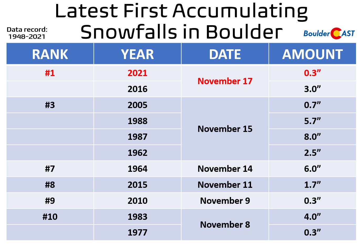
The chart below shows the date of Boulder’s first measurable snowfall for each year dating back to 1948. Measurable means that officially 0.1″ or more of snow was recorded. As is often the case early in the snow season, a few flakes mix in with rain, or flurries briefly fly, but never stick to the ground. These are instances where a trace of snow has occurred, but wasn’t measurable. For the purposes of the contest, we don’t care about these non-measurable snowflakes. We want actual accumulation! You can see there is a huge variation from year-to-year in the date of our first measurable snowfall. The earliest was September 8, 2020, with 1.7″ of snow falling. The latest measurable snow was November 17 of 2016 and 2021. That’s a spread of two and a half months! The normal (median) date of our first snow is October 19th.
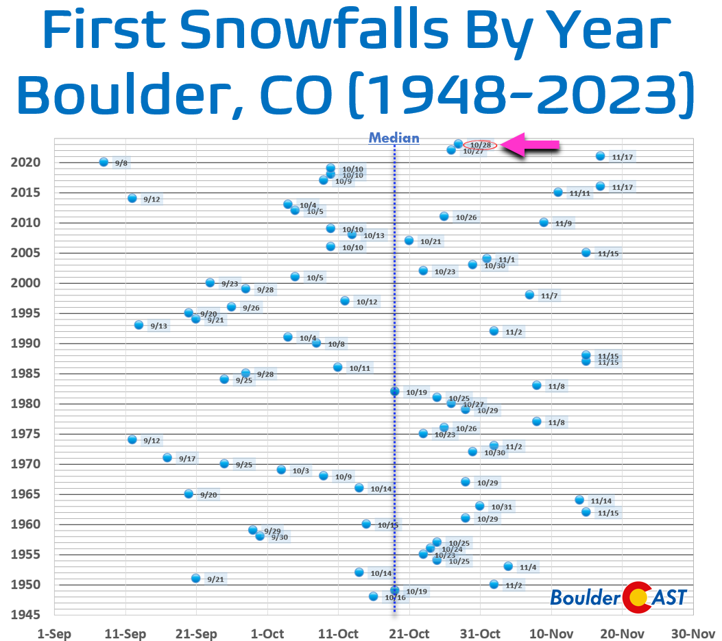
How about a few percentiles for the gamblers out there? The odds of our first measurable snowfall occurring on or before…
- September 21st: 10%
- October 4th: 25%
- October 19th: 50% (MEDIAN)
- October 30th: 75%
- November 12th: 90%
Our first measurable snowfall occurs in September 22% of the time, in October 55% of the time, and in November 23% of the time.
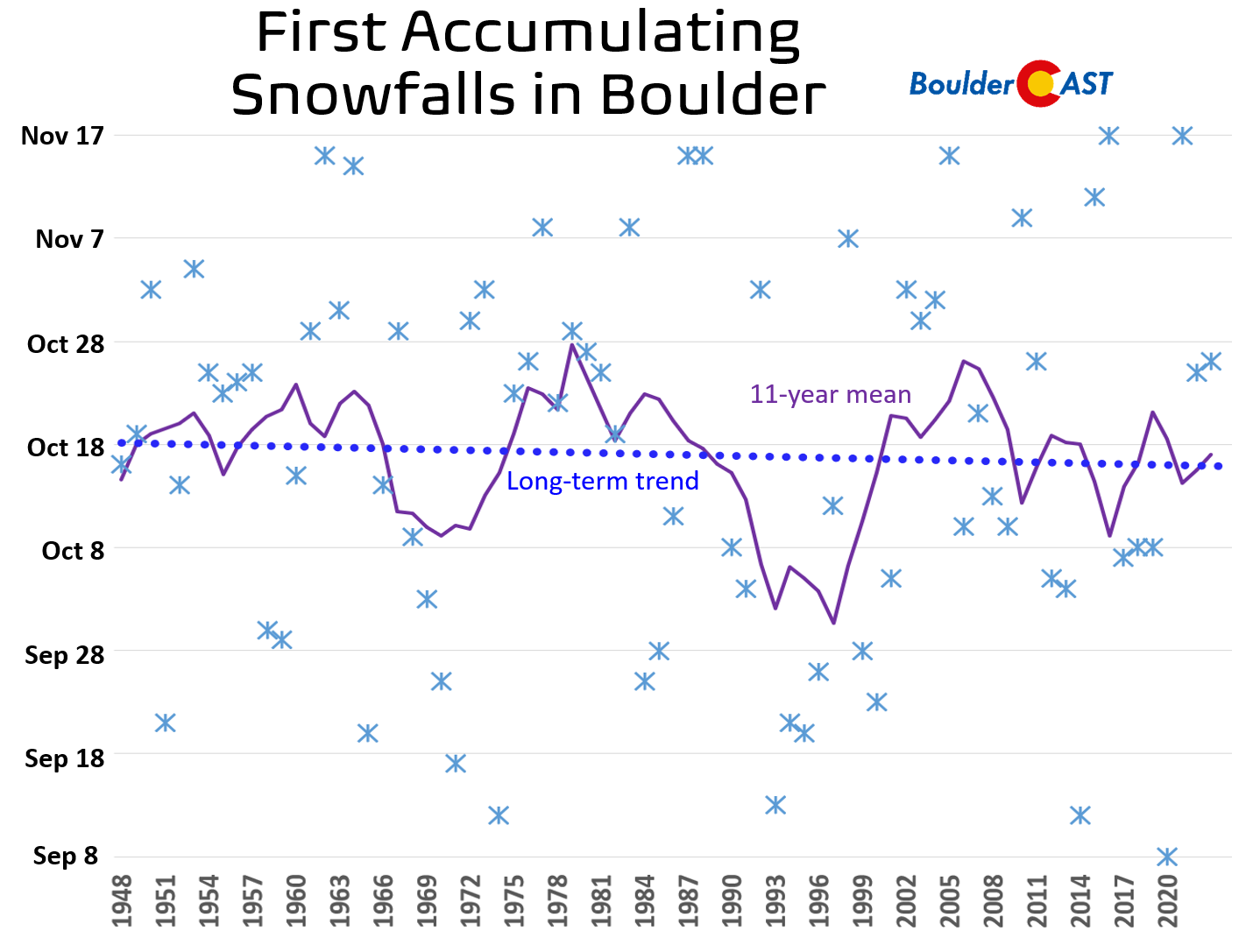
Despite ongoing rapid climate change, the long-term average and trend, though clearly not statistically significant, are leaning towards earlier occurrences of Boulder’s first snowfall. You may want to keep that in mind for your guess this year!
Data: 1948-2023
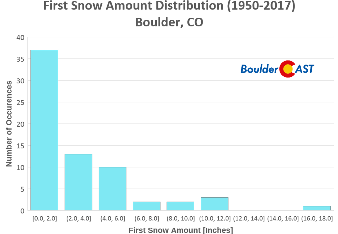
As you might imagine, our first snow event each year is usually only a small amount…providing an introductory taste of winter. The histogram below shows that 37 years from 1950 to 2017 had an inaugural snowfall less than 2.0″ (54% of the time). Boulder’s first snow only exceeded 6.0″ on 8 occasions (12% of the time). The average amount of Boulder’s first snow is 3.0″, while the median amount is 2.0″.
First snows of Boulder’s recent past
As mentioned earlier, Mother Nature has been throwing huge wrenches into our annual “first snow” contest constantly over the last few years. Here’s just a quick reminder on how our first accumulating snowfall went down over the last five years…
2019
Our inaugural accumulating snow in 2019 occurred on October 10th alongside an Arctic Blast surging into the center of the country. The frontal passage in our area was followed by 2 to 3 hours of heavy jet-forced snow bands. Boulder officially recorded 3.8″ of snow from these bands.
GOES-East infrared satellite animation from Wednesday morning (9/9/20)
Temperatures also dropped like a rock accompanying this first snow. Denver plummeted nearly 70 degrees in just 18 hours, from the 80s one day into the record-setting teens by the following morning. Needless to say, the 2019 growing season came to a rather abrupt end.

GOES-East infrared satellite animation from Wednesday morning (9/9/20)
2020
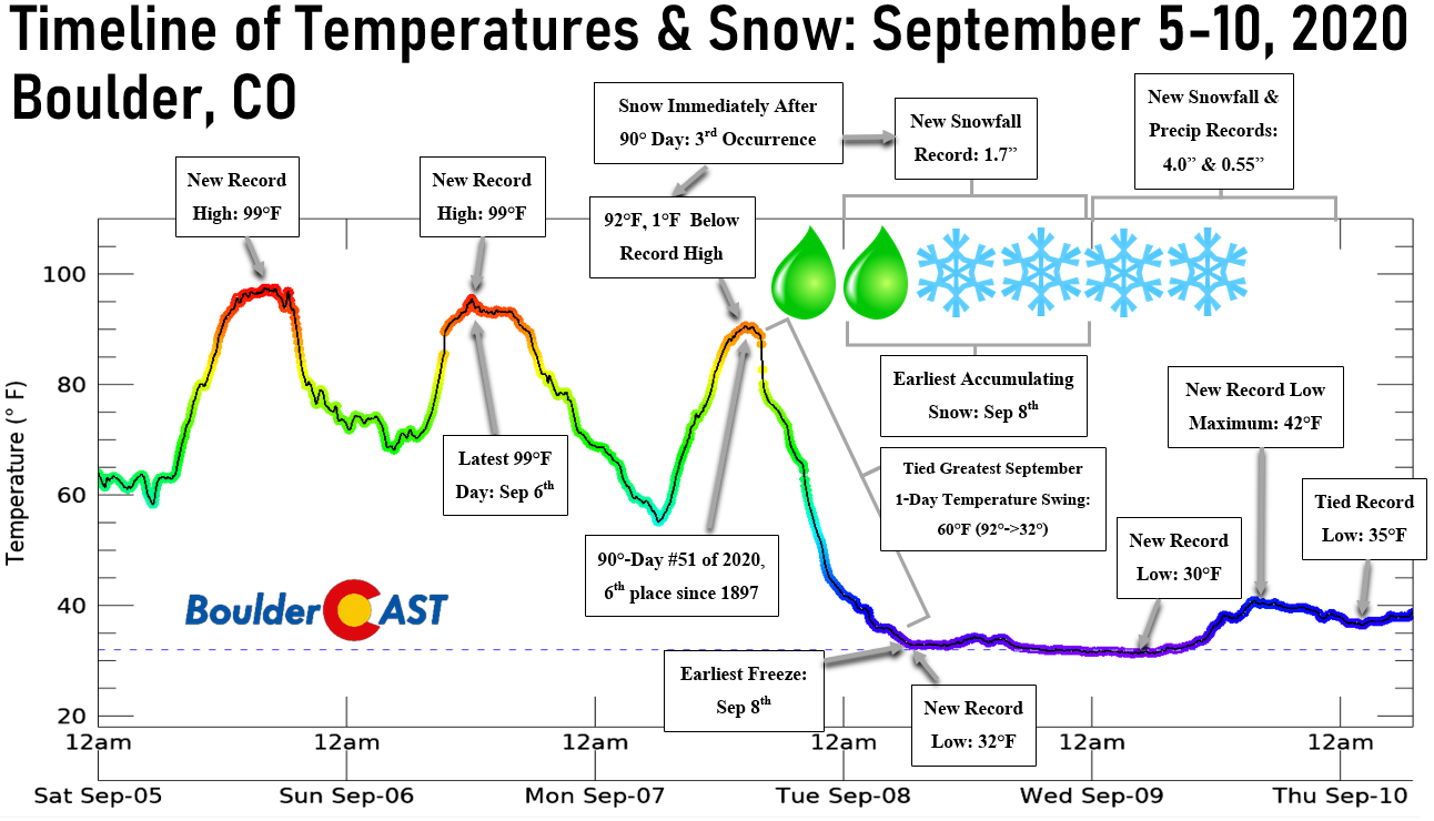
In 2020, we had our earliest accumulating snowfall on record in Boulder on September 8th — before the first snow contest was even announced that year! This led to an unprecedented “second” snowfall contest taking shape. The first snow record was just one of many obliterated during the highly anomalous Great Labor Day Snowstorm of 2020 in the Front Range!
GOES-East infrared satellite animation from Wednesday morning (9/9/20)
2021
In 2021, the summer and autumn season both were extremely warm and dry in our area. Boulder ended up tying for its latest ever first snowfall on November 17th — a measly 0.3″ that only accumulated on grassy surfaces following several hours of very light snow overnight. This historically delayed first snow resulted in all of the contest participants being way off. The person who guessed the latest date won the contest by default. After that crazy late first snow, there was only another inch of additional snow that fell over the next five weeks which further primed the dry prairie grasses in the lead up to the Marshall Fire tragedy in late December 2021.
2022
The first snow in 2022 was a bit of a disappointment with a rain/snow mix occurring during the daytime hours on October 27th. Boulder recorded an absolutely bare minimum first snow with only a dusting sticking on the grass, and that was only in SOME parts of town as temperatures were mostly above freezing. This led to a lot of confusion when we announced that the contest was over, as some people never even saw a snowflake in their location!
Snow only accumulating on the “cooler” parts of Boulder. In most cases, this was the slightly higher western areas, but also in the grasses. Credit: NWS
2023
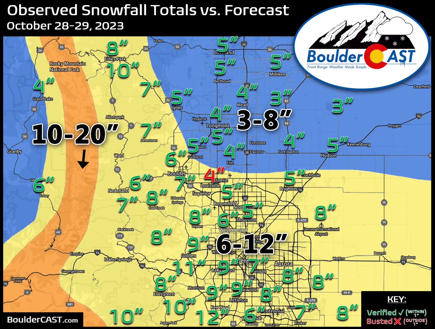
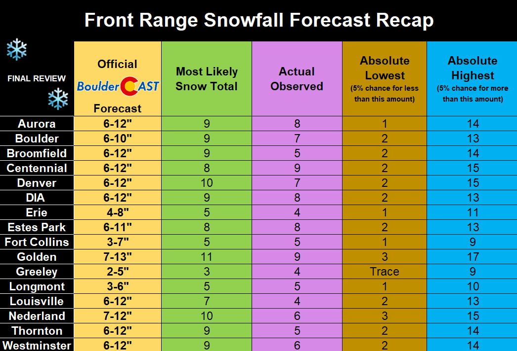
2023 was the most normally-timed first snow for us in recent memory, unfolding only about a week later than usual. However, this first dumping was on the larger side as a cluster of well-forecasted jet-forced snow bands targeted the Denver Metro area with heavy snow for several hours. When it was all said and done, most Front Range cities picked up between 5 and 10″ of snow. Boulder officially recorded a two-day storm total of 6.8″.
Enter our 2024 First Snow Contest!
Without further adieu, let’s move on to the contest! This is a community poll for the date you think the first MEASURABLE snowfall will occur in Boulder. Those who come closest to the actual date are the winners. For verification, we’ll go off the official Boulder climate station located at the NIST building in south Boulder (FYI, they follow UTC time for date cut-offs — roughly 5PM to 5PM local time).
For prizes, we’re giving away BoulderCAST Premium subscriptions and Amazon Gift Cards. Among many perks, Premium members get full-access to our daily forecast discussion every morning. This is especially useful in the winter, when our meteorologists brain-dump thoughts for days leading up to impactful snowstorms. In case you weren’t with us over the last nine winters, we tend to do very well for the entire Denver Metro area (2015-2016 Recap / 2016-2017 Recap / 2017-2018 Recap / 2018-2019 Recap / 2019-2020 Recap | 2020-2021 Recap | 2021-2022 Recap | 2022-2023 Recap | 2023-2024 Recap). Premium members also have admittance to our full suite of weather model graphics, complete 6-day hiking and 6-day ski forecasts, smoke forecasts, plus have exclusive access to some content such as video forecasts and weather quizzes.

Go Premium, get all the perks.
Daily Forecast Updates
Get our daily forecast discussion every morning delivered to your inbox.
All Our Model Data
Access to all our Colorado-centric high-resolution weather model graphics. Seriously — every one!
Ski & Hiking Forecasts
6-day forecasts for all the Colorado ski resorts, plus more than 120 hiking trails, including every 14er.
Smoke Forecasts
Wildfire smoke concentration predictions up to 72 hours into the future.
Exclusive Content
Weekend outlooks every Thursday, bonus storm updates, historical data and much more!
No Advertisements
Enjoy ad-free viewing on the entire site.
The prizes for the contest are as follows:
- 1st place: 12-month Premium subscription + $35 Amazon Gift Card
- 2nd place: 6-month Premium subscription + $15 Amazon Gift Card
- Anyone who guesses within 1 day OR 0.1″ correct: 2-month Premium subscription
- All other entries: Virtual “pat on the back”
IMPORTANT: In the event that multiple participants select the same winning date (they will), the tie-breaker of snowfall amount will be used.

To get things started, here are the dates that some of the BoulderCAST Team has placed their bets on for our first snow:
- Andrew: October 22nd – 3.0″
- Ben: October 22nd – 2.5″
- Josh: November 4th – 4.0″
- Keah: November 9th – 3.0″
- Matt: December 4th – 6.0″
Enter you NAME, EMAIL, and guesses for DATE and AMOUNT in the form below on or before Wednesday October 2nd, 2024. Please only one entry per person.
BOULDERCAST 2024 FIRST SNOW CONTEST ENTRY FORM
*Sorry but this contest is now closed to entries*
*We respect your privacy. Your email will not be used for anything more than to contact you in case of meteorological victory.*
Prizes and recognition will be awarded in the days following our first dumping of snow. Let’s hope it’s a big one — good luck!
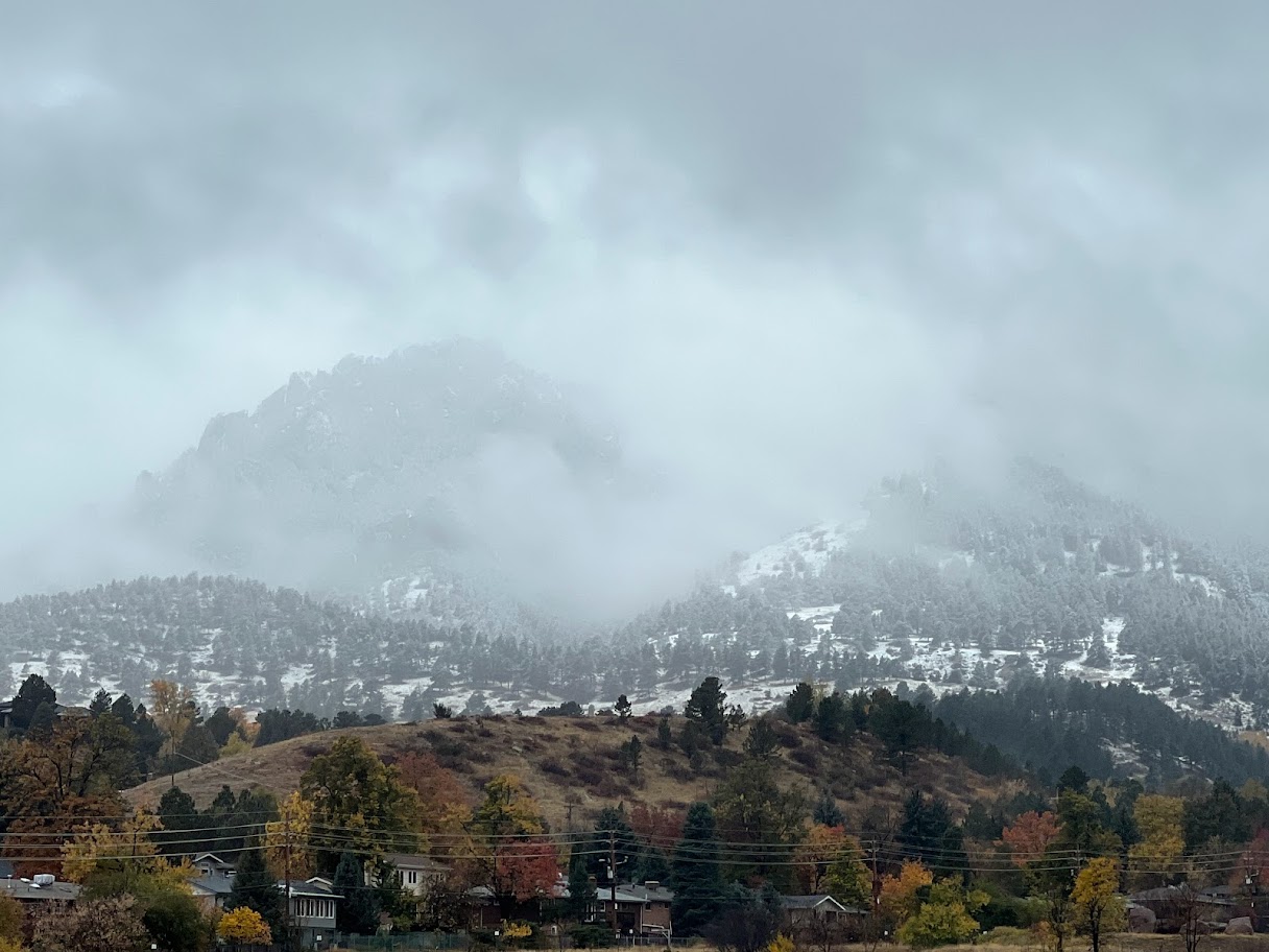
Photo taken along Trail Ridge Road in Rocky Mountain National Park, May 2019
Help us reach more people before winter! Share this contest with your friends:


You must be logged in to post a comment.