September was exceedingly dry and warm across much of eastern Colorado. Consequentially, the wildfire threat is increasing with each passing day. More than half of Boulder County is now under a complete fire ban. Will October offer up the soaking rain and mountain snow that we desperately need? Read on as we examine Boulder’s climatology and consider the current state of the atmosphere to give our outlook for the next month.
As mentioned, things have been warm and parched across the Front Range. Boulder was officially 7.0 degrees above normal for high temperatures (including five 90+ degree days), with only 0.14″ of rain for the month of September. Tuesday’s light rain ended a 22-day dry streak, but September will still go down as the 9th driest September on record (shockingly, yes there were actually eight other years with less than 0.14″!). From the maps below, it is clear the tale of September was written similarly across much of the country.
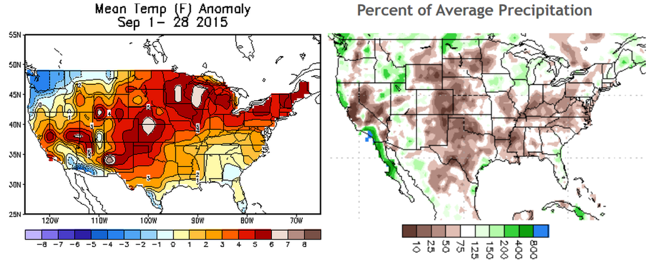
Precipitation and temperature departures from normal for the continental USA for the month of September.
This pattern was in glaring contrast to what was expected for the month. The semi-active pattern during the beginning of the month just didn’t drop much rain for us. Passing weather systems swooping down from the north were no match for the ridge/dry air mass that was and remained in place. Furthermore, the sub-tropical pattern in September continued to steer many of the tropical cyclones in the eastern Pacific to the west (except for Tropical Depression 16-E, but even that just gave us a few extra clouds). This helped to keep the deep, tropical moisture away from our region. The monsoon also didn’t put up much of a fight in September, disappearing within the first few days of the month (arguably, it may have died out for Colorado in mid-August).
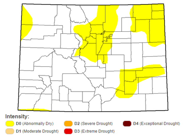
As a result, drought once again is starting to become part of the conversation. Here is the most recent analysis from the National Drought Mitigation Center (from September 24, 2015):
26% of our state is now considered “Abnormally Dry,” up from 10% the previous week (Sept 15th), now including the entirety of Boulder County. It’s not a dire situation just yet, but things are exceptionally dry out there. For now, respect the fire ban and let’s hope October can turn the tide!
Normally, October across the Front Range is quite beautiful, with mild, sunny days and nights starting to feel quite chilly. It doesn’t rain all that much, but snow can be a game-changer (particularly during El Niño years). Let’s take a closer look.
Precipitation:
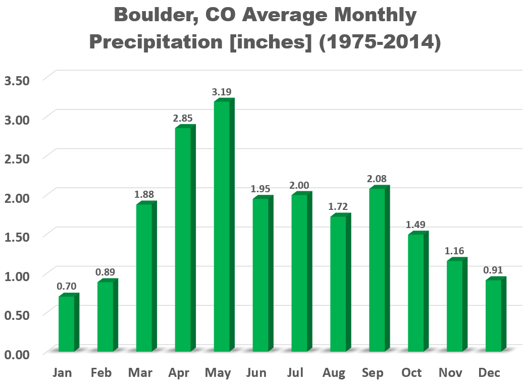
On average, Boulder receives 1.49″ of precipitation in October, marking the beginning of the “dry season” for much of the Mountain West, including Colorado.
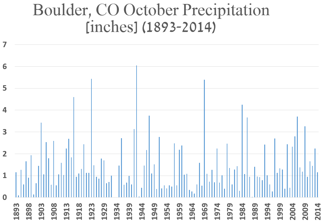
The graph below shows October precipitation totals since record-keeping began in Boulder.
Most October’s have less than 1.5″ of precipitation, however, in 1942, 6.04″ was recorded, thanks in part to 23.0″ of snowfall. Speaking of the white stuff, October is typically when we see our first snowfall of the winter season, averaging about 5″ in Boulder for the month. However, snow-less Octobers have occurred 32 times since 1897 (including October 2014), about once every four years.
Under strong El Niño conditions, like those that are present now, the Front Range is more likely to receive big snow storms in October, and through the winter. Take a second to fully grasp that last sentence…bigger snows, not necessarily more snow. In 1997, the year with an El Niño most similar to this year’s (in terms of strength), holds the current October snowfall record. All 30.1″ of that record accumulated in a single storm. 2009 was a moderate El Niño year, and also had 30.1″ of snowfall, 23″ of which came during one blizzard. If there is one month that stands out for big snows during El Niño , it’s definitely October!
Temperature:
October continues the drastic, downward trend in temperature that started in September. The average high temperature plummets from 72 degrees on the first of the month, to just 58 degrees by Halloween. The hottest temperature for the month was 90 degrees, observed on October 1, 1953. On the 26th of October in 1917, the temperature dropped to a chilly -2 degrees. Quite the range of possibilities!
Outlook:
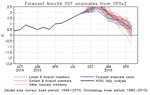
Over the last month, we have seen the intensity of El Niño track along the lower bounds of model projections. What does this mean? It is hard to say, but the “doomsday” anomalies could be a bit overdone. It is clear, though, that El Niño will persist through just about all of our snowy season.
Based on our analysis from a previous post, under moderate to strong El Niño conditions, there is a slightly elevated chance for precipitation in the month of October, including the increased likelihood of big snow storms. There is also an increased chance of no snow at all. These two polar-opposite outcomes may seem like forecast to “cover all the bases.” In reality, El Niño is just one small piece of a very complex and highly unpredictable puzzle that is Earth’s atmosphere. As far as temperatures, Boulder’s median daily high temperature drops 2.1 degrees under these conditions. We should keep these adjusted tendencies close-at-hand, as potentially the strongest El Niño on record continues to evolve.
Model consensus shows a relatively active pattern over the Mountain West for the first half of October. We don’t see any reason for the first half of the month to remain quiet, with as many as four troughs slated to impact Colorado. Because of the aforementioned factors, we a predicting slightly above normal precipitation, with near-normal temperatures.
The Climate Prediction Center comes to a similar conclusion. Based on numerous long-range models, and a slight consideration of El Niño, they put equal chances for Boulder County for precipitation and temperature. This basically means anything could happen! If it means anything to you, we are right on the edge of slightly elevated chances of both above normal precipitation and temperatures for October.
With that said, grab your fall attire, turn off the air conditioning, and enjoy the cool and fresh October air. Before you know it, leaves will changing, snowflakes will be flying, and neighborhood children will be knocking at your door demanding your sugar-filled treats!
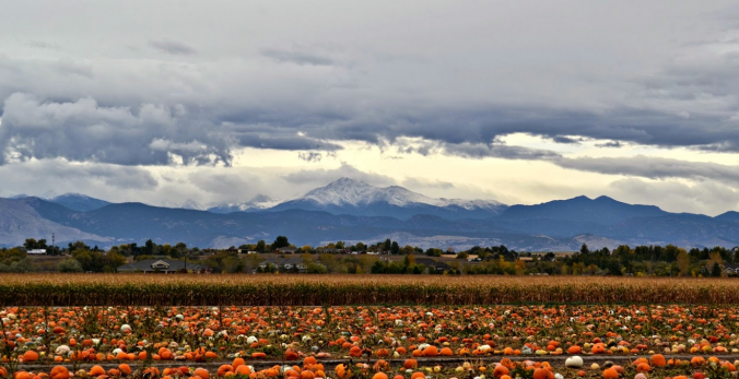
Featured image: Anderson Farms in Erie, CO (credit to buildingourstory.com)



You must be logged in to post a comment.