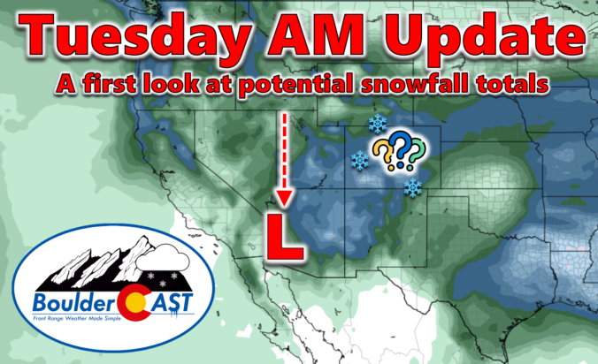
One last beautiful day will unfold across the area today before winter weather arrives to the Front Range Wednesday and sticks around into Friday. We provide the latest forecast details on the approaching winter storm, one which will have widespread significant travel impacts for the entire area. We also provide our preliminary snowfall forecast map. Spoiler alert: some areas could receive up to 30 inches of snow!
At a Glance
- Major Winter Storm Confirmed: A significant winter storm approaching the Front Range and is expected to bring substantial snowfall and travel impacts from late Wednesday into Friday.
- Storm Details & Timeline: The cut-off low pressure system will take a very unusual track this week, making the forecast extra challenging. However, strong northeasterly winds are expected to contribute to heavy snowfall rates Wednesday night into Thursday, particularly in and near the Foothills. Snow will decrease in intensity Thursday night and then fully come to an end on Friday.
- Snowfall Forecast: Preliminary predictions suggest some areas could receive up to 30 inches of snow in the higher terrain. Across the lower elevations, the heaviest snowfall will be west and south of Denver with up to 20 inches possible. Lower totals, less than 6 inches, are favored north and east of Denver.
- Travel Impacts: Our weather will shift dramatically on Wednesday with rain changing to heavy snow Wednesday evening. Travel will become difficult Wednesday night through Thursday, especially in the higher terrain where roads may be closed and become impassable.

Go Premium, get all the perks.
Daily Forecast Updates
Get our daily forecast discussion every morning delivered to your inbox.
All Our Model Data
Access to all our Colorado-centric high-resolution weather model graphics. Seriously — every one!
Ski & Hiking Forecasts
6-day forecasts for all the Colorado ski resorts, plus more than 120 hiking trails, including every 14er.
Smoke Forecasts
Wildfire smoke concentration predictions up to 72 hours into the future.
Exclusive Content
Weekend outlooks every Thursday, bonus storm updates, historical data and much more!
No Advertisements
Enjoy ad-free viewing on the entire site.
A
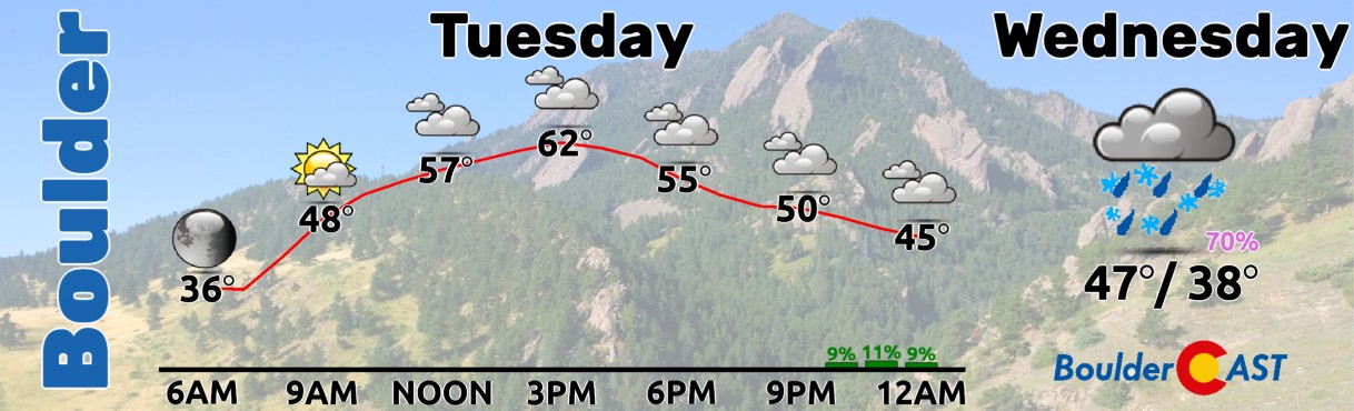
lrighty folks! Let’s get all the nice weather out of the way quickly here. Tuesday will be another pleasant March day across the Front Range as we sit briefly between storm systems. Skies shouldn’t be quite as drab as Monday, but there will still be a fair amount of wave clouds around later on to keep our skies at least partly cloudy, if not mostly cloudy, through the mid to late-day period. High temperatures will be above normal in the lower 60s, though. Try to wander outside and enjoy today if you can as big changes to our weather commence tonight after dark and only get worse heading through the rest of the week!
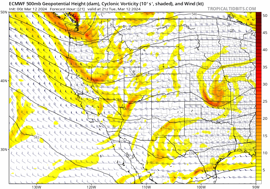
OK, now onto the good stuff! All of our team’s focus remains on the incoming major winter storm headed to the Front Range in the days ahead. A cut-off low pressure system will take an atypical track from the Pacific Northwest Wednesday morning straight southward into Arizona by Thursday afternoon, providing a glancing blow of sorts to much of Colorado as it passes by and stalls some 800 miles to our southwest. The latest European 500mb height forecast animation is shown below. This system is taking a very odd track and there isn’t many analogs for this scenario in the historical record — something that makes this forecast all the more challenging — and potentially disastrous. Normally a storm this far west would be of minimal consequence for our area, but against all odds, this one looks to create at least a 24-hour period of very favorable conditions for heavy snowfall in the Front Range, and an even longer period of light snowfall lingering for additional 12-24 hours thereafter.
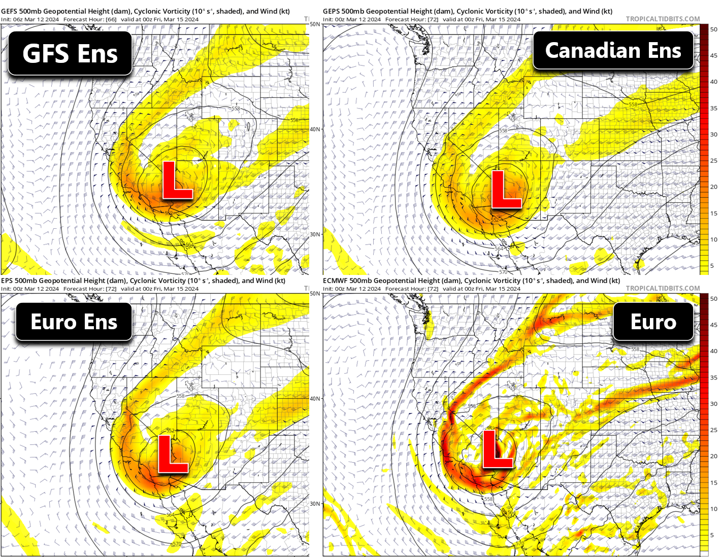
Since our last forecast update Monday morning, we’ve seen most modeling suites generally trend towards the European solution, one which places the low pressure a bit further southwest along the Arizona/California border by Thursday evening. For the most part, all models are now onboard with this location. While this shift slightly further southwest won’t impact things too much, we have seen the likelihood of an “all-time largest snowstorm” type of scenario fade a bit, though there is still a slim chance for that.
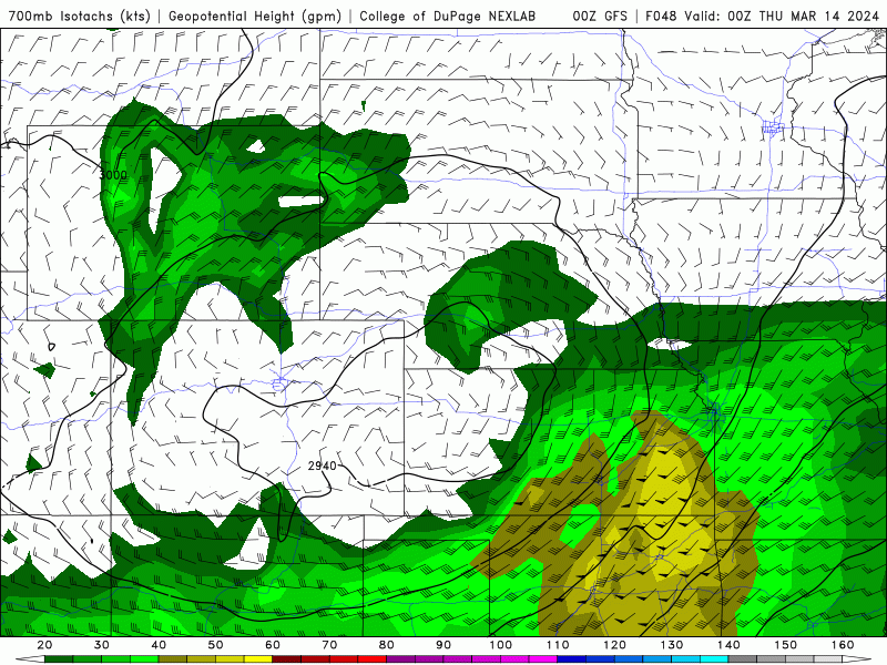
Despite that slight disappointment, this will certainly still be a significant and highly impactful snow event for the entire Front Range, with the focus of the heaviest snow being west and south of Denver in the Foothills and across the Palmer Divide. We really can’t get past just how strong and persistent northeasterly upslope is shown to be Wednesday night into Thursday evening. 30 to 40 MPH northeasterly winds will be slamming into our terrain for close to 24 consecutive hours. The GFS model’s depiction of these potent upslope winds is shown in the animation below for the ~10,000 elevation level. While northeasterly wind is not the most efficient direction — that would be due easterly — this upslope setup is concerning. This is especially true when considering there will be other overlapping lifting mechanisms present from an ejecting shortwave across Colorado and some mid-level instability. The only ingredient truly absent from this storm’s repertoire is jet forcing — a lack of which often comes with the territory when dealing with cut-off systems. Snowfall rates will be ~1″ per hour much of the time from late Wednesday night into Thursday afternoon, especially in and near the Foothills where rates may even be 2-3″ per hour at times. While the best upslope and forcing will begin to relax Thursday evening, there will still be some weaker upslope around Thursday night and into part of Friday with lighter snowfall expected to continue (~1/4″ per hour snowfall rates).
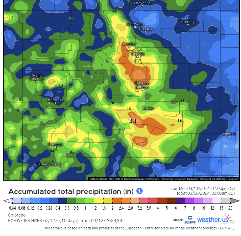
As far as potential moisture totals, amounts are expected to land between 0.75 to 2″ for most of the Metro area, with greater than 2″ possible the southern Foothills which will be favored most by the northeasterly upslope wind direction. The latest European model forecast below is a solid “middle of the road” look at the spatial distribution of things and aligns with our current thinking for this event. We do note that there are quite a few models still showing higher amounts for the area (up to twice as much in some cases!) but those have generally trended somewhat downward in recent runs.
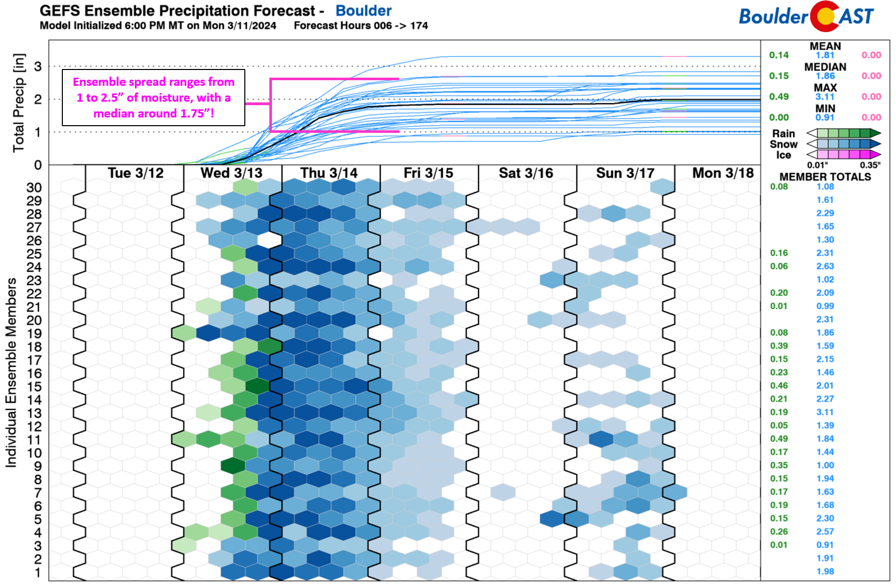
Looking more closely at Boulder, the GFS ensemble spread has tightened up a bit over the last 24 hours, something that is expected but not always guaranteed as a storm draws closer and models get a better handle on things. The current spread is roughly between 1″ and 2.5″ of moisture, with a mean of ~1.8″. Note here that initially it will be too warm for snow across the lower elevations on Wednesday when temperatures will be in the 40s and widely scattered rain showers will be around. However, we should see a relatively quick shift to snowfall as precipitation begins to ramp up Wednesday evening, with a change-over timing probably landing between 6PM and Midnight Wednesday evening. We’re still a bit cautious of this timing as some models are showing slightly less cold air filtering into the area. However, given the precipitation intensity expected, it seems more plausible we would cool off sooner rather than later. Nonetheless, some amount of the precipitation will be “lost” to rainfall early on across the lower elevations.
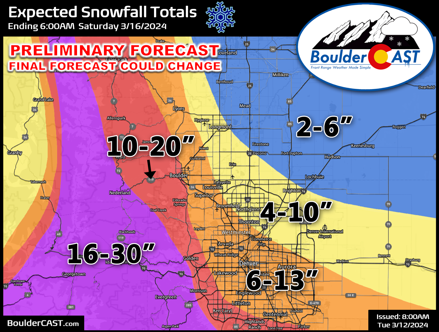
Our initial, very preliminary snowfall forecast map is shown below. The highest totals of up to 30″ are expected in the higher Foothills where temperatures will be colder (all snow, no rain, best snow ratios). Across the lower elevations, there will be a strong gradient in snowfall with the highest amounts west and south of Denver. Boulder is likely to see between 10-18″ of snow, highest on the west side of town. Downtown Denver is looking at 6-12″. Areas off the northeast will be warmer and see less upslope forcing — only 2-6″ is expected for places like Greeley, Loveland and Fort Collins. We must caution that this initial forecast map is very much on the conservative side. There is a disproportionate amount of evidence to support higher-end totals, compared to lower-end. We will deal with any need to bump up totals slightly as the storm approaches.
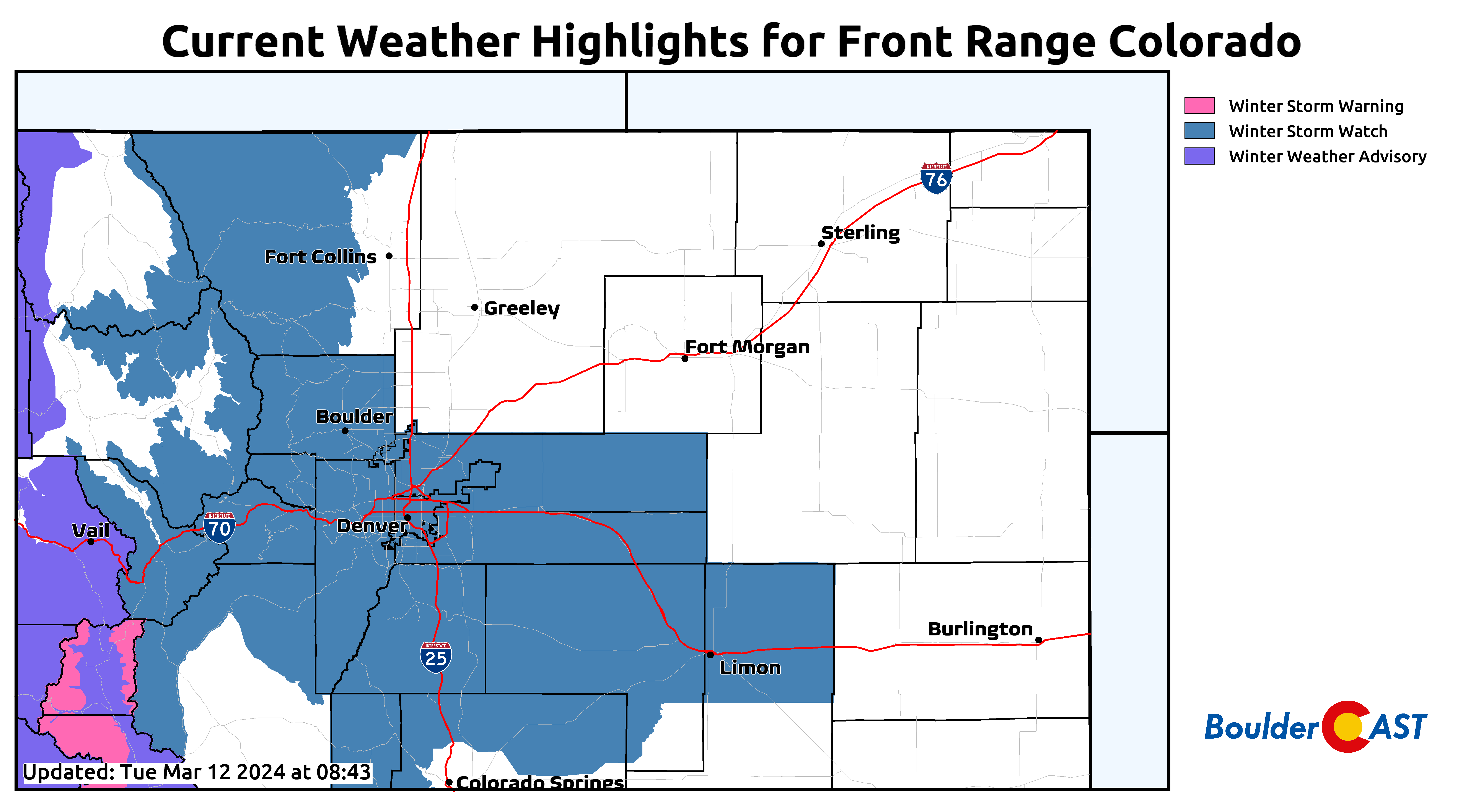
Currently a Winter Storm Watch is in effect for the entire Metro area, Foothills and Mountains. Most of these will almost certainly be upgraded to a Winter Storm Warning today or tonight.
Here’s a breakdown of where things stand as of Tuesday morning…
WHAT WE KNOW NOW:
- Tuesday will be dry and warm with increasing wave clouds — try to find some time to enjoy the nice 60-degree weather!
- A cold front moves through Tuesday night with a chance of rain showers overnight in the Metro area
- Wednesday will be cooler with a low-end chance of rain showers during the day — highs in the 40s
- Rain showers will increase quickly towards sunset Wednesday with a change-over to snow occurring sometime Wednesday evening
- Accumulating snow is guaranteed for the whole of the Metro area, with the highest totals expected to be south and west of Denver, including around Boulder. Areas north and east will see lower end snow totals (FoCo, Loveland, Greeley, Longmont)
- Snowfall amounts above 12″ are guaranteed in the Foothills above 7000 feet from Boulder County southward. Upwards of 36″ will be possible in some Foothills communities, likely those would be in Jefferson or Gilpin Counties. Roads may become impassable across the higher terrain Wednesday night through Thursday. Plan for ubiquitous roadway and mountain pass closures.
WHAT WE DON’T KNOW YET:
- The exact change-over timing from rain to snow across the lower elevations (it’s likely to happen between 6PM and Midnight Wednesday evening).
- How much snow will ultimately accumulate in the Denver Metro area and nearby terrain (looking like 6-18″ in the Metro, with 10-30″ in the Foothills).
- When snow will come to an end (probably around midday Friday, but could be a bit sooner or later)
WHAT WE WILL CONTINUE TO WATCH:
- Mid-level low pressure track: Where will the storm system stall out? Will it end up further northeast in Arizona like the GFS is showing (more favorable for heavy precipitation here), or further southwest like the Euro?
- Cold air: When will the change-over timing be from rain to snow? Right now it looks like all snow takes over sometime Wednesday evening, but precipitation intensity (or lack thereof) could push this sooner or later. Some models do suggest a later change-over timing and this needs to be watched closely for a potential lower elevation bust scenario. With such a long duration storm, we also need to watch for some melting to occur during the day Thursday. Snow on the ground may wane a bit despite snow continuing, especially Thursday afternoon when temperatures will be near or slightly above freezing.
- Upslope directionality throughout the duration of the storm: While upslope will be strong and long-lasting, we need to monitor the direction. Will winds end up being more northerly favoring the Palmer Divide instead of the Boulder area? More northerly winds could also wipe out much of the snow from Longmont northward to Fort Collins which would see downslope and warmer temperatures as a result. Do winds turn southeasterly towards the tail-end of the storm which isn’t all that favorable for the Denver area?
BOTTOM-LINE: A high-impact, MAJOR winter storm is on-track to hit the Denver Metro area and Front Range Foothills/Mountains late Wednesday in to Friday. Impacts are expected to be widespread and significant, especially Wednesday night into midday Thursday. This is still an evolving forecast and some changes in timing and snowfall amounts will likely be needed over the next 36 hours until the storm arrives.
We’ll keep you updated as this MAJOR winter storm approaches and unfolds. While this particular storm is not expected to be historic at this time (i.e it likely won’t crack the Top 5 Biggest Snows list), that isn’t completely off the table yet. Stay tuned and subscribed!

Get BoulderCAST updates delivered to your inbox:
Go Premium, get all the perks.
Daily Forecast Updates
Get our daily forecast discussion every morning delivered to your inbox.
All Our Model Data
Access to all our Colorado-centric high-resolution weather model graphics. Seriously — every one!
Ski & Hiking Forecasts
6-day forecasts for all the Colorado ski resorts, plus more than 120 hiking trails, including every 14er.
Smoke Forecasts
Wildfire smoke concentration predictions up to 72 hours into the future.
Exclusive Content
Weekend outlooks every Thursday, bonus storm updates, historical data and much more!
No Advertisements
Enjoy ad-free viewing on the entire site.
Enjoy our content? Help us out and give it a share:


You must be logged in to post a comment.