It will be business as usual the first two days of the week with 60-degree temperatures and dry conditions continuing. However, a major storm system will drop south into the Desert Southwest this week, with impacts expected in the Front Range Wednesday through Friday. All signs point to a significant dumping of upslope precipitation in our area from this storm, most of which will fall as heavy wet snow. There’s still a lot of uncertainty in this week’s forecast, but let’s discuss the latest developments in what could be a historic March winter storm for the Denver Metro area.
This week’s highlights include:
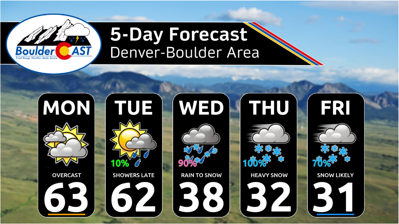
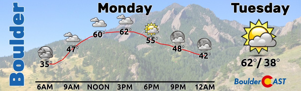
- Quite Pleasant Early in the Week: The week starts with warm temperatures in the 60s and dry conditions. A minor storm system will bring increased cloud cover on Monday, but no significant precipitation is expected on the Plains.
- Major Storm System Inbound Mid to Late Week: A significant storm is forecasted to impact the Front Range from Wednesday to Friday, likely bringing heavy snowfall to the entire area. The storm’s track will be crucial in determining the severity of the weather event in the Boulder-Denver area.
- Snowfall Predictions: While there is uncertainty in the exact amounts, the forecast suggests a substantial amount of precipitation, mostly in the form of snow, due to prolonged upslope conditions. Upper-end projections would put this as a historic winter storm for us.
- Forecast Uncertainties: The exact timing of the change-over from rain to snow and total snow accumulations are still uncertain. Stay tuned for updates!
DISCLAIMER: This weekly outlook forecast is created Monday morning and covers the entire upcoming week. Accuracy will decrease as the week progresses as this post is NOT updated. To receive daily updated forecasts from our team, among many other perks, subscribe to BoulderCAST Premium.

Go Premium, get all the perks.
Daily Forecast Updates
Get our daily forecast discussion every morning delivered to your inbox.
All Our Model Data
Access to all our Colorado-centric high-resolution weather model graphics. Seriously — every one!
Ski & Hiking Forecasts
6-day forecasts for all the Colorado ski resorts, plus more than 120 hiking trails, including every 14er.
Smoke Forecasts
Wildfire smoke concentration predictions up to 72 hours into the future.
Exclusive Content
Weekend outlooks every Thursday, bonus storm updates, historical data and much more!
No Advertisements
Enjoy ad-free viewing on the entire site.
A spring-like start to the week
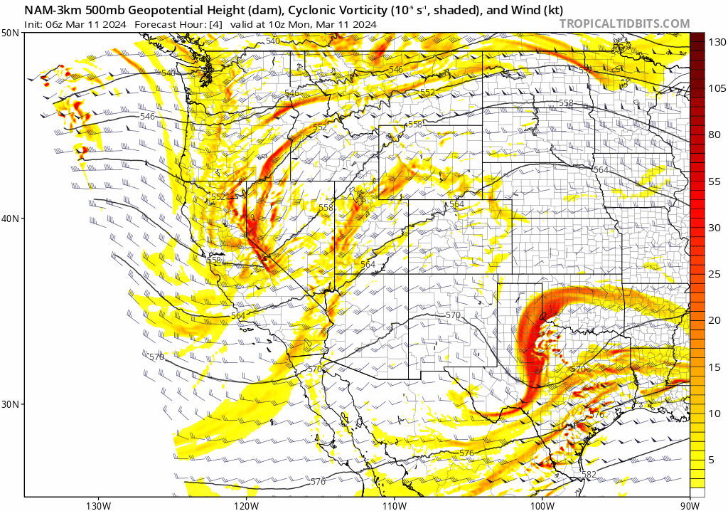
This week will begin right where the weekend left off — key word being begin — with fairly warm temperatures and mostly dry weather across the Front Range. A weak storm system is approaching from the Great Basin to our west with increasing, moisture-laden flow aloft already pushing into the area as of writing Monday morning. Notice the surge of clouds/moisture into Colorado in the latest GOES-East water vapor animation below.
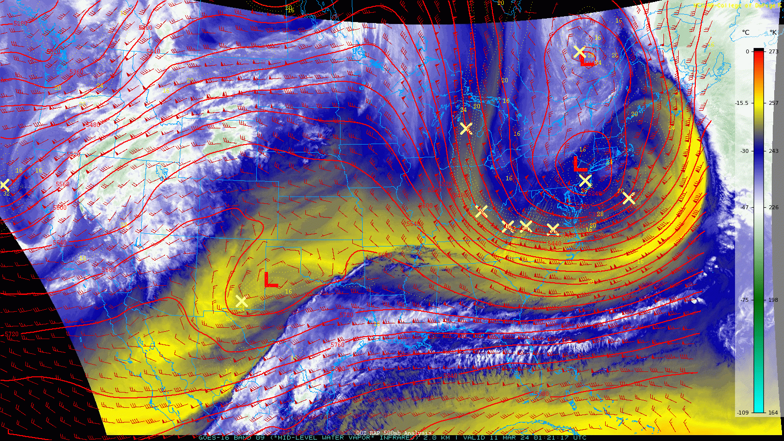
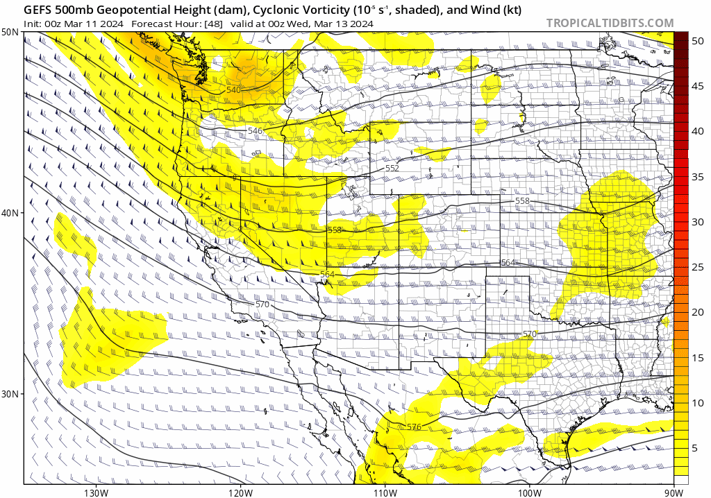
The disturbance which came ashore in northern California Sunday night will slide eastward across Salt Lake City Monday afternoon and then through Denver area early Tuesday (see animation below). There will be a few scattered rain/snow showers across the Mountains today into early Tuesday from this system, but we will remain dry down on the Plains. A secondary, much larger disturbance enters the scene from the northwest towards the end of the animation below. This is the first sign of our primary and soon-to-be MAJOR weather-maker for mid to late week. More on that beast in a moment.
As a result of the incoming minor shortwave, our weather will shift slightly early in the week. The completely clear skies we had over the weekend will be replaced with thick clouds on Monday, at least for most of the day. We could start to see some partial sunshine work in late in the day. Temperatures will stay very comfortable in the 60s once again. Tuesday will have less cloud cover initially thanks to brief subsidence from the departing storm, but rain showers will begin to develop during the evening and overnight associated with the next storm system and a cold front dropping in from the northeast. That won’t happen until the evening/overnight though, with Tuesday offering up another stellar March day with highs in the lower 60s and partly sunny skies.
Major snowstorm highly likely late Wednesday through Friday!
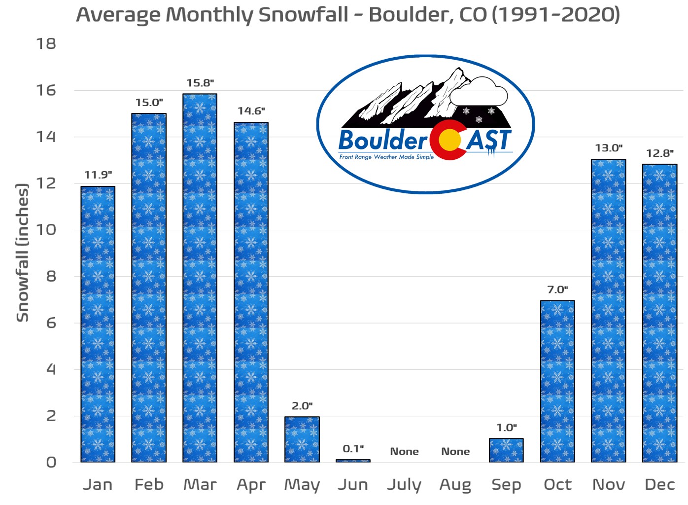
It may be starting to feel like spring out there these days, but as you already know, winter rarely goes away without a fight in the Front Range — especially during El Niño! March is our snowiest month of the year for a reason after all, with Boulder averaging close to 16″ of snow in a month that typically offers the perfect mashup of springtime moisture and winter’s lingering cold air. The expected major storm system dropping out of the Pacific Northwest and western Canada later this week will indeed bring both seasons together resulting in quite a messy forecast for the Boulder-Denver area!
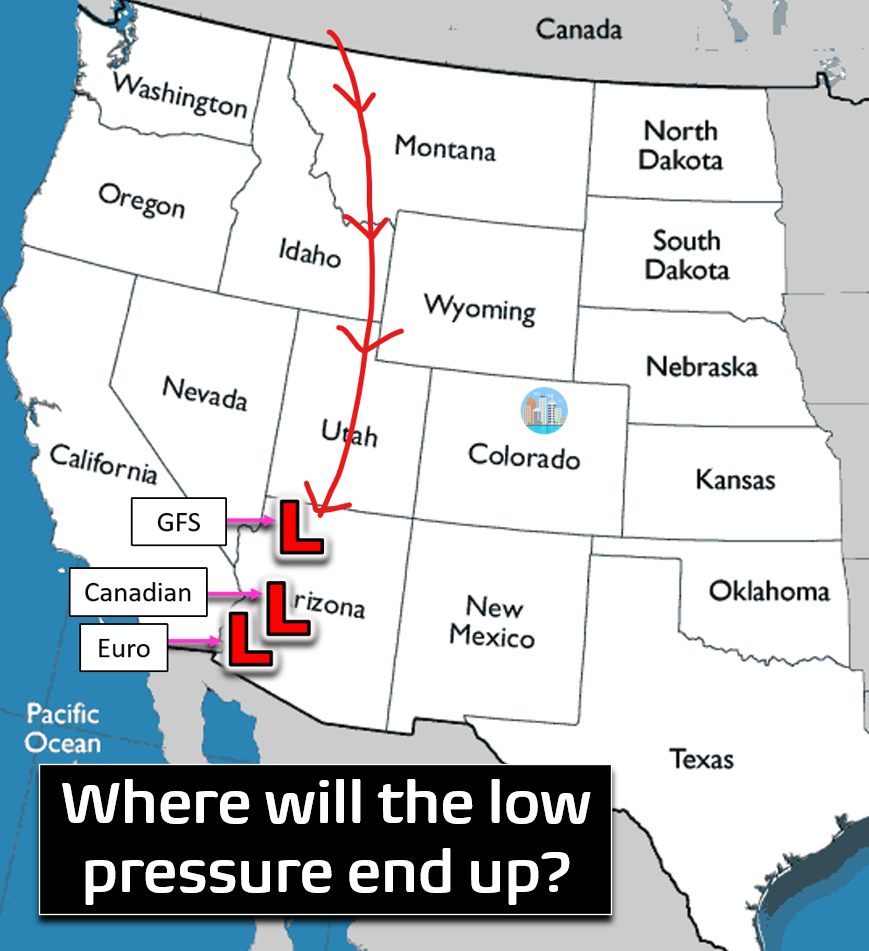
The developing storm will take a precarious track from Montana on Tuesday almost due south (and a bit west) into southwest Arizona by midday Thursday. Once it reaches Arizona, it could stall out for several additional days as it slowly wobbles and weakens. Check out the storm’s evolution in the Euro ensemble 500mb mean forecast animation below which runs from Tuesday through Saturday. While a track this far westward typically wouldn’t be all that favorable for northeast Colorado, this storm is huge and slow-moving with impacts that will encompass our area and likely persist for a long time — in the ballpark of 48 to 72 hours, depending on which model you look at.
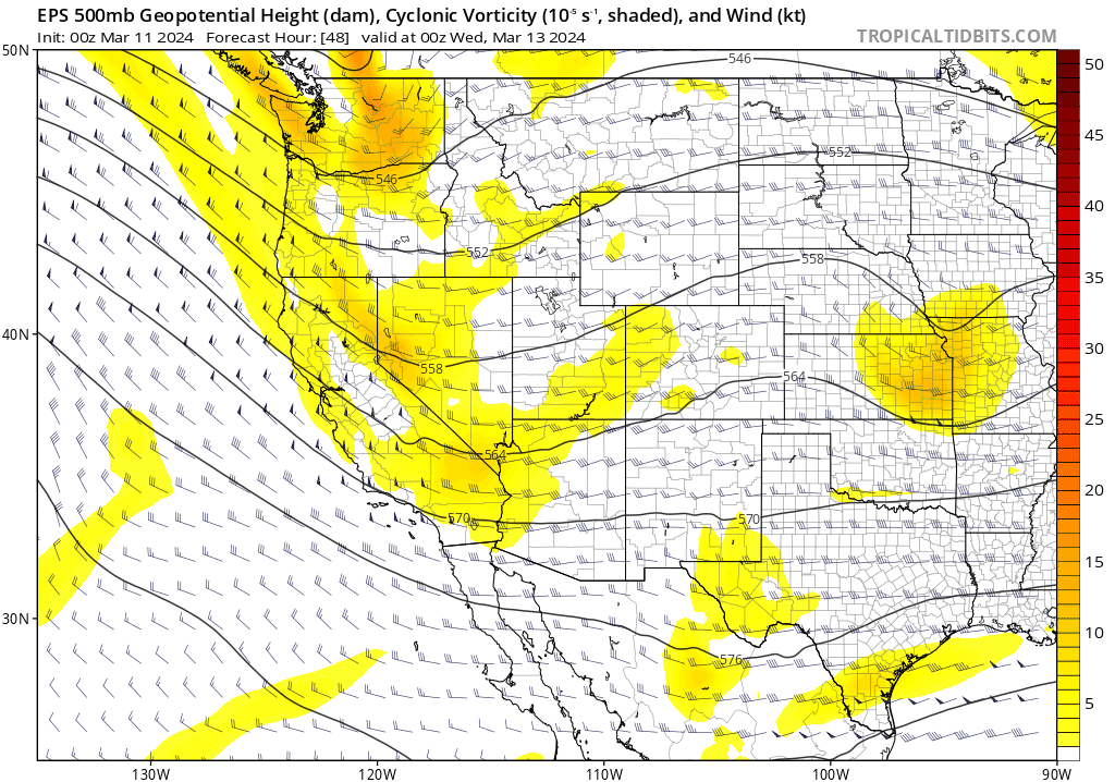
Speaking of, model ensembles are relatively consistent with the track of this storm, though there is considerable variation in their individual members. The Canadian ensemble mean forecast (below) is extremely similar to the Euro: western Montana Wednesday morning, Utah Wednesday night, and southwest Arizona Thursday and beyond:
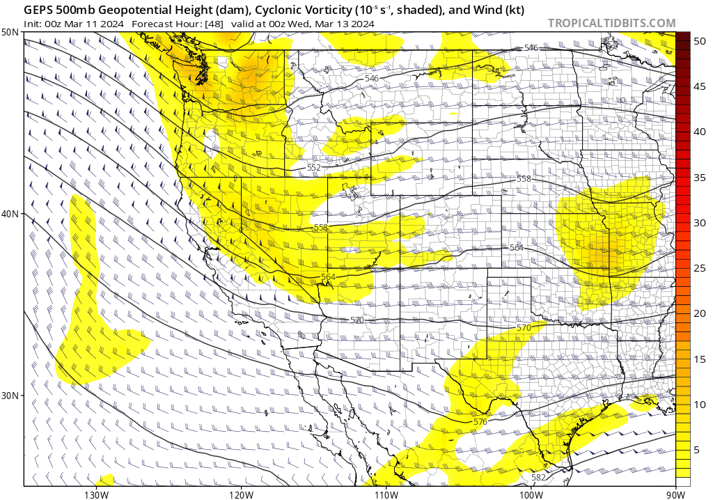
The GFS ensemble is also rather similar, though there are some differences, mainly that the final resting place of the storm lands a bit further north and eastward in Arizona — a location that would be slightly closer to our area and thus more favorable.
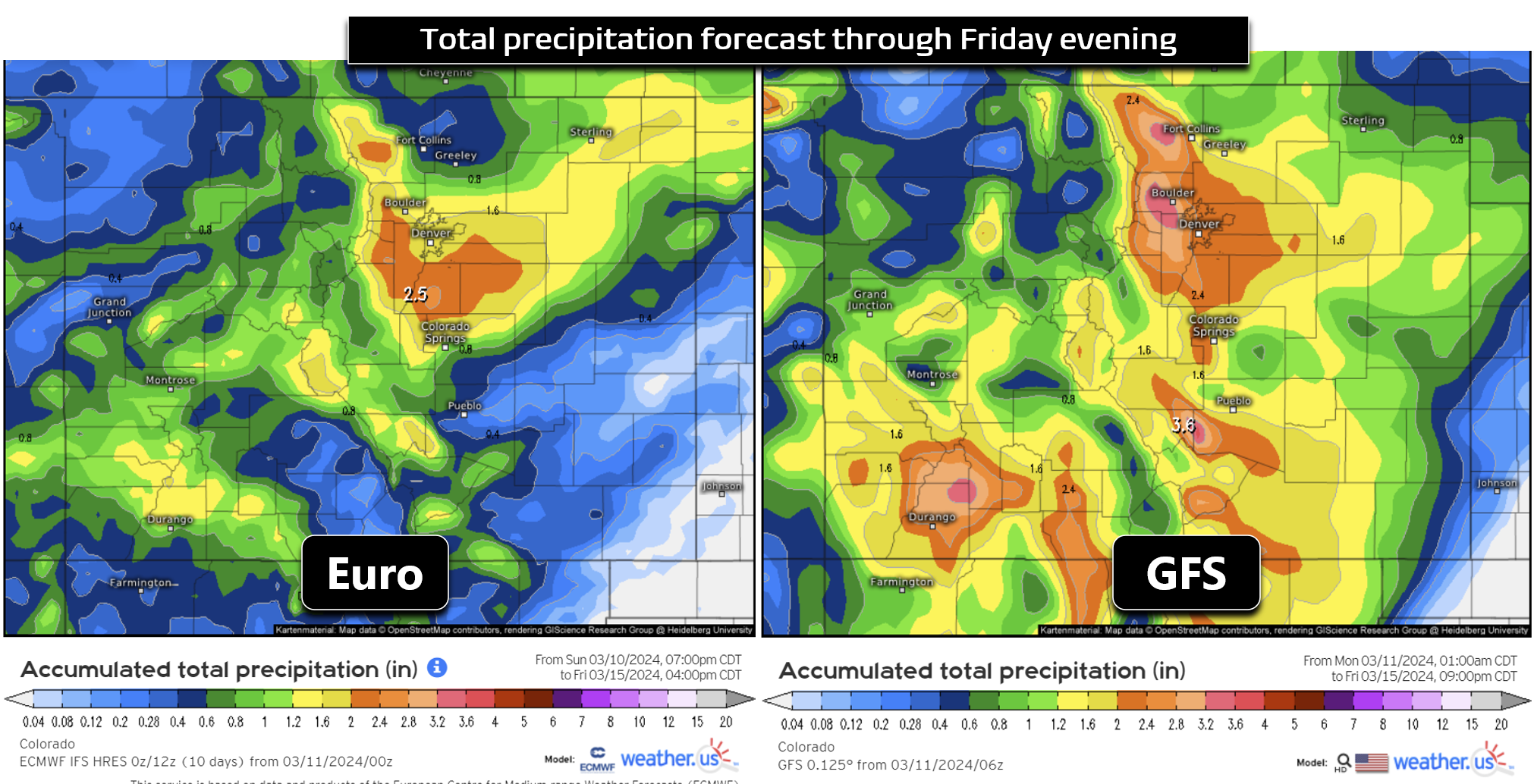
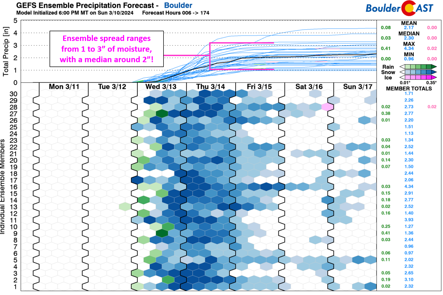
While all models are absolutely pummeling the Denver Metro area with moisture later this week, the GFS is currently advertising 1.5-3″ of precipitation for Boulder and Denver (!), while the Euro is more like 0.75-2″.
The exact track of this storm and where it ultimately ends up on Thursday will play a critical role in determining whether this is only a beneficial dump of moisture/snow for us, or perhaps something bordering on historic!
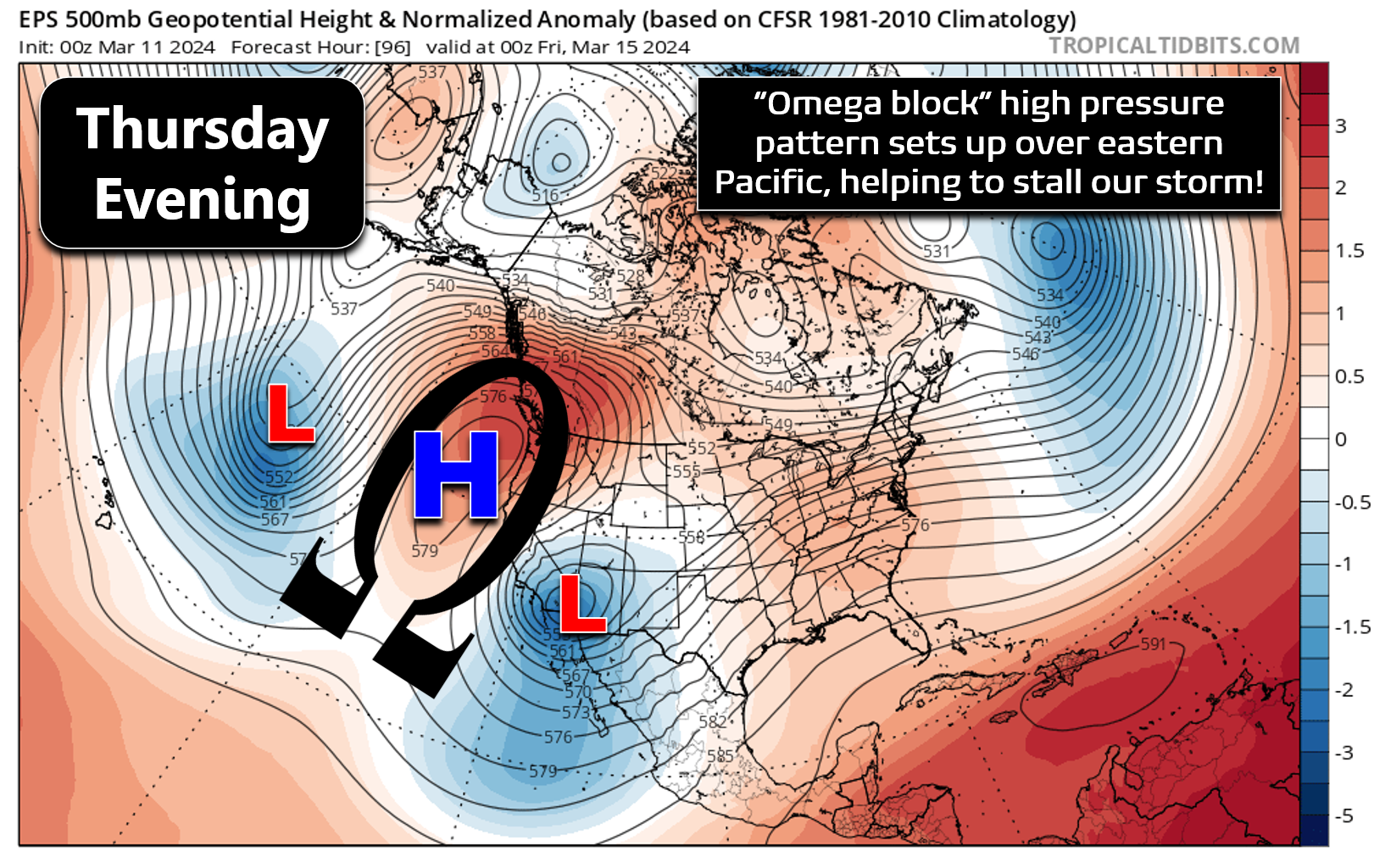
The storm lingers across Arizona for so long thanks to a developing “omega block” pattern over the eastern Pacific Ocean, a setup that shuts off the flow upstream and prevents any substantial westerly winds from helping to kick the storm eastward — thus it lingers for days on end. Some models fail to rid this storm from the American Southwest until the middle of next week — essentially keeping it stationary over the Desert for seven days or more. There are a lot of tricky factors at play in this week’s forecast — it’s not going to be a simple one (is it ever?). With that said, almost every outcome possible with this one results in substantial precipitation for the Front Range — with most of it falling in the form of snow!
Regardless of which model solution ultimately verifies, unsettled weather and precipitation in the Front Range will predominantly be driven by long-lasting, deep, moisture-rich upslope flowing into northern Colorado from the east-northeast. This juicy upslope setup will persist in some form for a solid 2 to 3 days, resulting in a hefty dump of moisture along the eastern slopes of the Front Range and adjacent Denver Metro area.
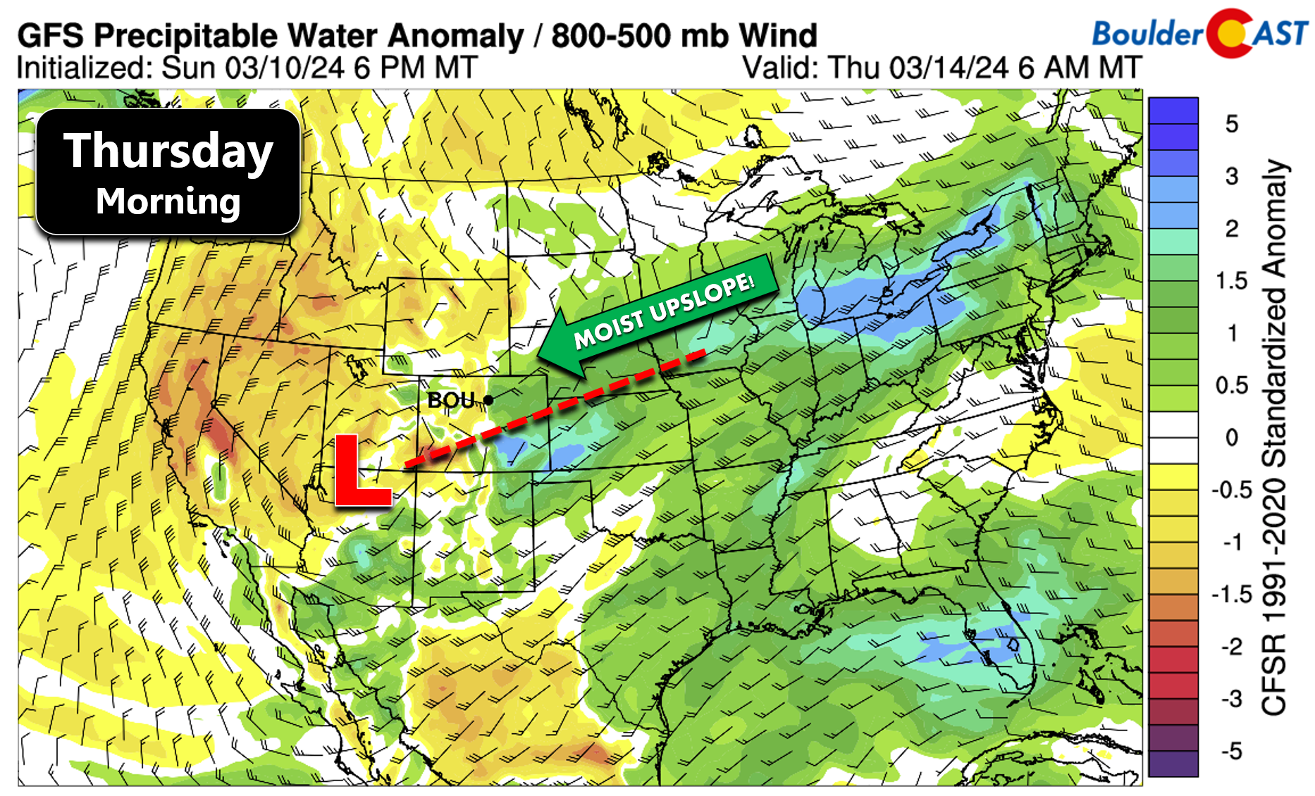
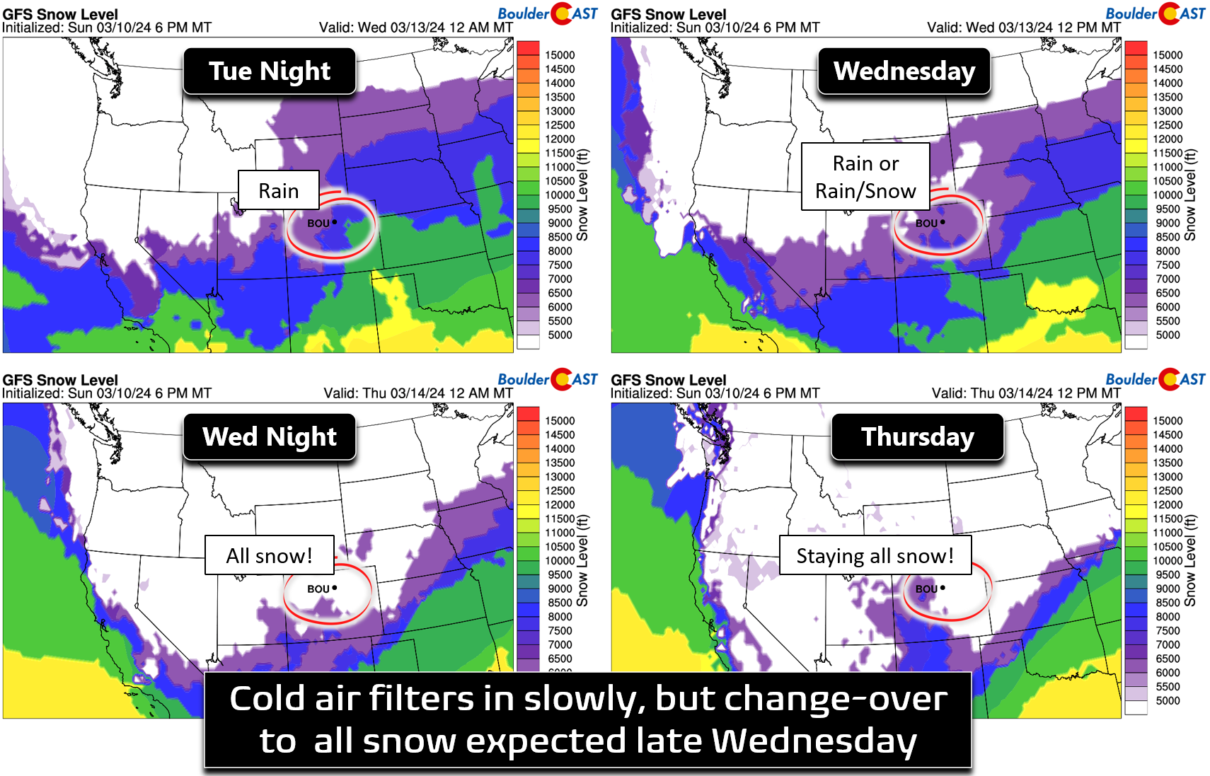
Rain showers will begin to develop behind the first front Tuesday night and continue on-and-off through Wednesday. Initially there won’t be enough cold air for accumulating snow on the lower elevations, but that will change later in the day Wednesday into Wednesday evening as a secondary push of cold air moves in (see snow level time series plots below). Wednesday will offer up mostly rain showers, though some snow mixing in is certainly possible by afternoon. It shouldn’t amount to much (if any) accumulation during the day. By late Wednesday though, temperatures should fall enough to allow for a change-over to all snow, with accumulation beginning and continuing for another 36 hours or more.
The devil will be in the details this week — cut-off storm systems like this never seem to behave as expected with models so often struggling to resolve the upper-low’s exact location more than two days in advance. While all signs are pointing to a significant winter storm for the Front Range this week, exactly how much rain and snow we get remains up in the air for now (pardon the weather pun!). For what it’s worth, the absolute lowest GFS ensemble member produces 1″ of moisture in Boulder (see below). However, the absolute lowest Euro member has ~0.25″, so there certainly an outside chance of this being a minor event.
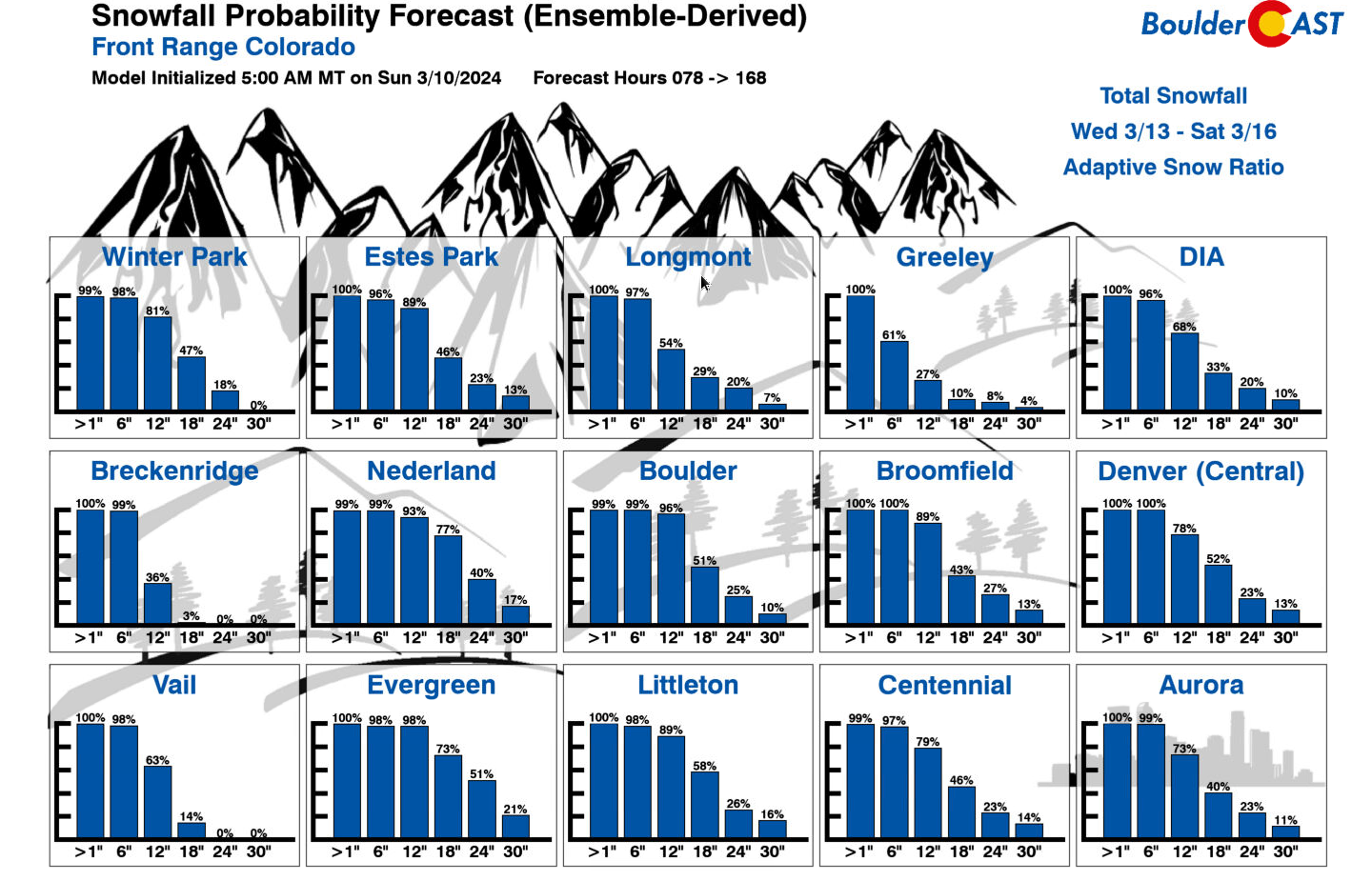
On the higher end, this could indeed be a crippling late-winter snowstorm for us, with our latest Snowfall Probability Charts indicating a significant chance for a foot of snow or more in many areas. We’re also even seeing about a 10% chance for 30″ of snow which would be one of the largest snow events ever to hit the Denver area. Keep in mind this isn’t our forecast right now, but it isn’t off the table just yet. Is it a coincidence this week is the 3-year anniversary of the epic March 2021 Front Range snowstorm? We think not!
Here’s a breakdown of where things stand as of Monday morning…
WHAT WE KNOW NOW:
- Monday and Tuesday will be mostly dry, warm and pleasant for early March
- Wednesday and beyond turn much colder with rain changing to snow as a big, wet storm envelops the central and southern Rockies
- Prolonged upslope will favor widespread precipitation in the Front Range Wednesday through at least Thursday night, but likely continuing into Friday
- Accumulating snow is guaranteed for the entire area, with amounts above 1 foot guaranteed in the Foothills above 7000 feet from Boulder County southward
WHAT WE DON’T KNOW YET:
- The exact change-over timing from rain to snow across the lower elevations (it’s likely to happen late Wednesday)
- How much snow will ultimately accumulate in the Denver Metro area and nearby terrain (huge totals are possible)
- When will this slow-moving storm will fully clear out (snow probably wraps up sometime Friday)
WHAT WE WILL CONTINUE TO WATCH:
- Mid-level low pressure track: How will the storm’s final resting place trend over the next 36 hours? Will it end up further northeast in Arizona like the GFS is showing (more favorable for heavy precipitation here), or further southwest like the Euro?
- Cold air: When will the change-over timing be from rain to snow? Right now it looks like all snow takes over late Wednesday, but precipitation intensity could push this sooner or later.
- Upslope directionality throughout the duration of the storm: Can we get any due easterly winds? Will winds end up being more northerly favoring the Palmer Divide instead of Boulder? More northerly winds could also wipe out much of the snow from Longmont northward to Fort Collins which would see downslope and warmer temperatures as a result. Do winds turn southeasterly towards the tail-end of the storm which isn’t all that favorable for the Denver area?
BOTTOM-LINE: A major winter storm is likely to hit the Denver Metro area and Front Range Foothills/Mountains later this week. Impacts are expected to be widespread and significant, but this is still an evolving forecast!
That’s all we have for now. It’s definitely going to be another wild week in Front Range weather, and thus a busy one for our team. We’ll keep you updated as things evolve and the storm approaches and unfolds. Stay tuned and subscribed!
Get BoulderCAST updates delivered to your inbox:
Forecast Specifics:
Monday: Mostly cloudy early, but some peeks of sun possible later in the day. Highs in the low to middle 60s on the Plains with lower 50s in the Foothills.
Tuesday: Some sun, but increasing clouds with rain showers developing in the evening and overnight hours. Highs in the lower 60s on the Plains with upper 40s in the Foothills.
Wednesday: Gloomy with a chance of rain or rain/snow showers during the day. Precipitation becomes more widespread later in the day with a full change-over to snow, heavy at times. Highs around 40 degrees on the Plains with lower 30s in the Foothills.
Thursday: Snow continues through the day, heavy at times. Highs around the freezing mark on the Plains with middle 20s in the Foothills.
Friday: Snow lingers into the morning at least, perhaps throughout most of the day. Highs stay cold near freezing on the Plains with 20s in the Foothills.
DISCLAIMER: This weekly outlook forecast is created Monday morning and covers the entire upcoming week. Accuracy will decrease as the week progresses as this post is NOT updated. To receive daily updated forecasts from our team, among many other perks, subscribe to BoulderCAST Premium.
Go Premium, get all the perks.
Daily Forecast Updates
Get our daily forecast discussion every morning delivered to your inbox.
All Our Model Data
Access to all our Colorado-centric high-resolution weather model graphics. Seriously — every one!
Ski & Hiking Forecasts
6-day forecasts for all the Colorado ski resorts, plus more than 120 hiking trails, including every 14er.
Smoke Forecasts
Wildfire smoke concentration predictions up to 72 hours into the future.
Exclusive Content
Weekend outlooks every Thursday, bonus storm updates, historical data and much more!
No Advertisements
Enjoy ad-free viewing on the entire site.
Enjoy our content? Give it a share!


You must be logged in to post a comment.