A high-impact, major El Niño snowstorm is about to unfold across the entire Front Range from late Wednesday into Friday. While we were a bit cautious of the eccentric model output over the last several days, all systems appear to be go for a significant, long-lasting dumping of heavy wet snow in the Denver Metro and nearby terrain. While there is still quite a range in the potential outcomes, we’ve seen enough to increase expected snowfall amounts across the board (again!). Read on as we sift through the latest model data and discuss the updated storm timeline and expected snowfall amounts. This one’s going to be a doozy!
Premium Storm Update (3/13/2024 8:00AM): The overarching forecast remains on-track as of Wednesday morning as a significant and highly impactful snowstorm bears down on the Front Range. Travel will become extremely difficult (and in some areas of the Foothills, impossible) Wednesday night into Thursday night, with some power outages expected. We wade through a wide gamut of the most recent model data, with trends suggesting a boom scenario is more likely than a bust. We also give our final thoughts on the impressive winter storm about to slam the Denver Metro area. READ HERE
Update (3/13/2024 3:00PM): The BOOM scenario has grown more favor with our team! As models continuing to trend upward on snow amounts, we’ve bumped up our official forecast totals a bit more. We’ve adjusted this entire post to be up to date with the latest information, including all graphics and discussion. BIG snow inbound! Be safe!
At a Glance
- Major Snowstorm On-Track: A significant El Niño snowstorm will slam the Front Range from late Wednesday into Friday, bringing heavy wet snow to the Denver Metro and nearby terrain
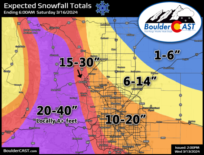
- Snowfall Amounts Have Increased: We have increased expected snowfall amounts, with Boulder and Denver having a near 100% chance to receive a foot of snow. There’s even 10% chance for historic snowfall of 30″ or more.
- Intense Convective Snow Followed By Intense Upslope Snow: The storm is predicted to bring intense upslope conditions with northeast winds of 30-50 MPH aloft over Denver for more than 24 hours, potentially leading to prolonged 1-3″ per hour snowfall rates. Upslope will be preceded by a multi-hour period of heavy convective snowfall Wednesday evening and part of the night.
- Impossible Travel: Travel will become very difficult to nearly impossible at times Wednesday night into Friday, especially in the Foothills where feet of snow will pile up. DIA is likely to shut down all of Thursday. Travel is highly discouraged during the height of the storm Wednesday evening into Friday morning.

Go Premium, get all the perks.
Daily Forecast Updates
Get our daily forecast discussion every morning delivered to your inbox.
All Our Model Data
Access to all our Colorado-centric high-resolution weather model graphics. Seriously — every one!
Ski & Hiking Forecasts
6-day forecasts for all the Colorado ski resorts, plus more than 120 hiking trails, including every 14er.
Smoke Forecasts
Wildfire smoke concentration predictions up to 72 hours into the future.
Exclusive Content
Weekend outlooks every Thursday, bonus storm updates, historical data and much more!
No Advertisements
Enjoy ad-free viewing on the entire site.
I
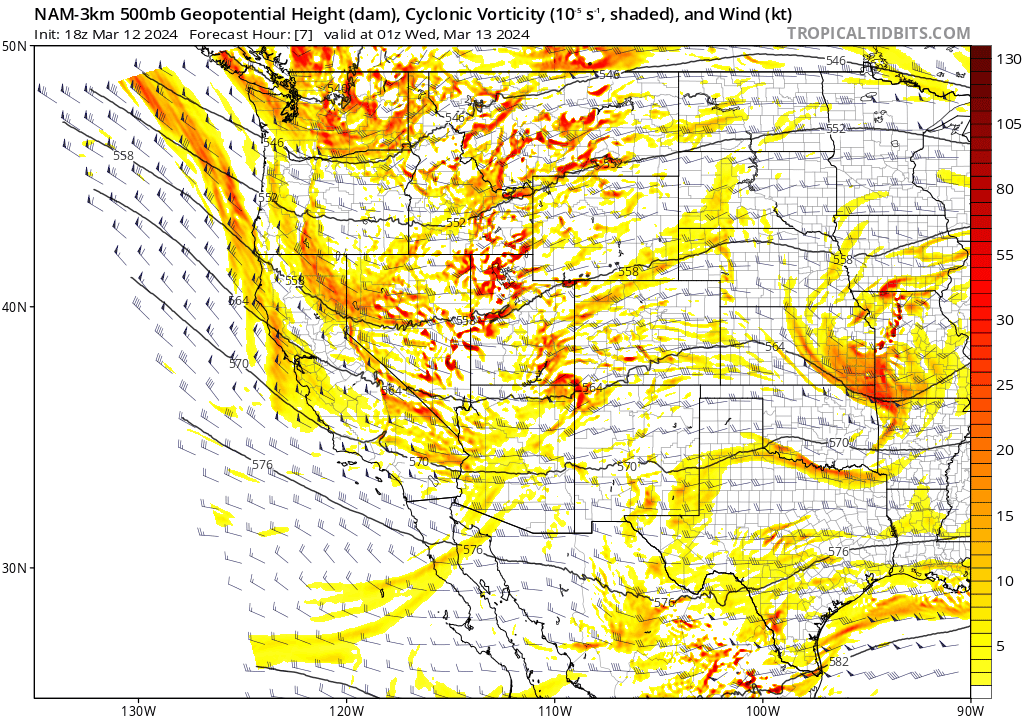
f you haven’t noticed, our team’s forecast demeanor has been somewhat cautious for this specific winter storm since first mentioning it last Thursday in our Premium weekend outlook. We’ve been partially burned by Mother Nature a few times this season, especially here in the New Year, with weather models advertising excellent dynamics and ingredients for snow, but at the last minute pulling the rug right out from under us. “Over-Promise & Under Deliver” has been a less-than-subtle motto for our snow storms recently. At this point Wednesday afternoon, we’ve managed to dodge the figurative rug being pulled out! We’re now quite confident that an explosion of heavy wet snow is about to dump across the entire Front Range in the coming 48 hours! We are fully on-board with some of the more outrageous model predictions we’ve been seeing for days now, but have not fully bought into previously. Remember the track of our incoming storm is an odd duck — a parent low pressure some 800+ miles away in the Sonoran Desert of Arizona will be pulling the strings and delivering the wallop of heavy snow to the Front Range this week!
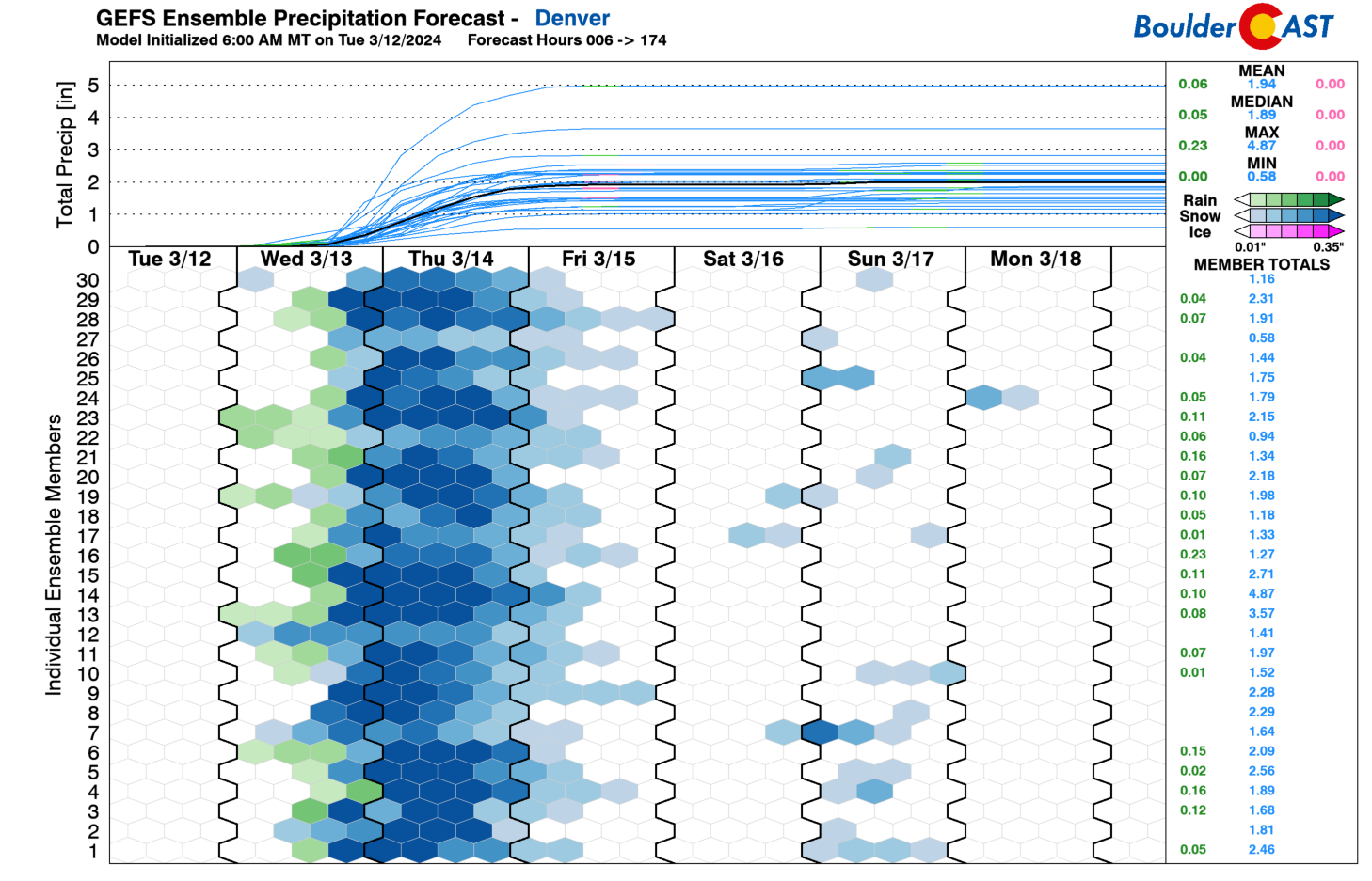
Ensembles have remained remarkably consistent for days now and there hasn’t been much change at all. Taking them at face value, both Boulder and Denver have ~90% chance to receive a foot of snow, and shockingly a 10% chance to see epic snow totals of 30″ or more. Yes historic snowfall remains on the table, but that is still a rather low probability outcome.

The inbound winter storm is packing an incredible amount of moisture, tapping directly into the Gulf of Mexico and slinging that moist air back westward into our steep terrain. There was some chance that this moisture might get wrung out in Nebraska due to a shortwave moving through. However, this no longer appears to be the case and we’ll indeed be getting that moisture. ALL the moisture!
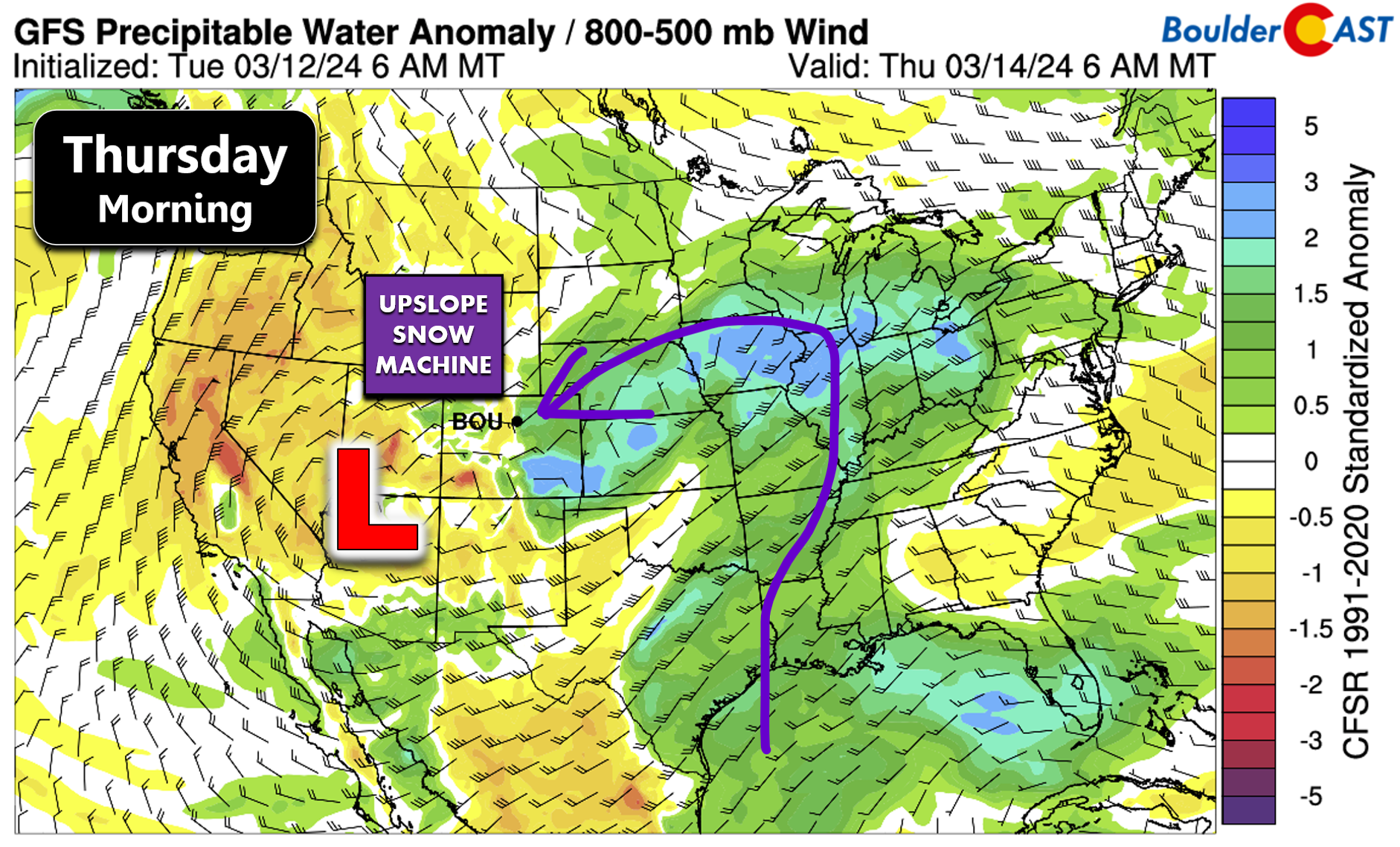
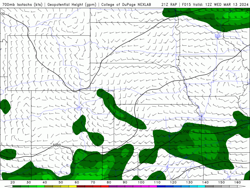
We continue to be amazed by both the intensity and duration of the upslope this atmospheric setup is creating over northeast Colorado. Just take a gander at the 700mb wind forecast below from the RAP model. Northeast winds of 30-50 MPH (!) are locked-and-loaded over Denver from Wednesday evening all the way into Thursday night — more than 24 hours with the upslope snow machine chugging along at full speed. Every single model is showing this extreme example of northeasterly upslope — so it’s hard to imagine this aspect of the storm letting us down. There are even a few models, like the NAM, which are hinting that winds may turn closer to due easterly some of the time. If that verifies, this would likely spawn a nasty barrier jet which would spread 2″+ per hour snowfall rates away from the terrain and out across the entire Metro area during the day Thursday. For now, this is also a low probability scenario, but it does bear close watching as it could push things even higher on the crazy snow spectrum.
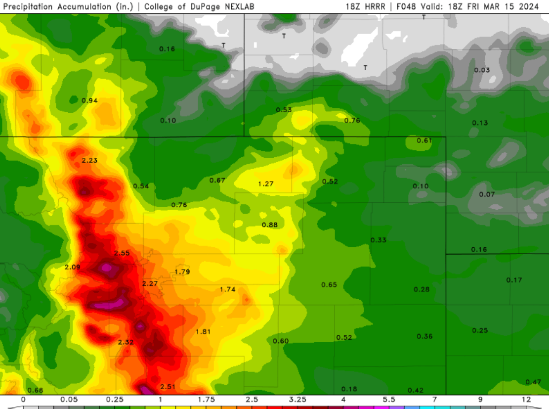
We’re now getting a complete picture for the short-range models as the snowy system draws closer — most of them predict just 36 to 48 hours into the future. Below is the simulated radar animation from the HRRR model from Wednesday afternoon through Friday afternoon. The HRRR is showing an initial wave of convective showers and even some thunderstorms Wednesday afternoon and early evening (which we’ve seen reports of already), but things transition to a juicy upslope/deformation snow event later on Wednesday night into Thursday. It’s the convective aspect of the storm which was not well captured by global models previously. This explosion of convection is likely to occur over the entire area Wednesday evening, rapidly cooling the air and turning rain to heavy snow. We were initially concerned about how quickly temperatures would come down and allow snow to stick, but that really isn’t an issue anymore, except maybe for areas well north and northeast of Denver.

The HRRR currently dumps over 2″ of moisture on the entire Denver area, with over 3″ in parts of the Foothills — this is incredible!
So you probably know where this discussion is leading…. Yes, we are increasing our expected snowfall totals (again!) as there continues to be almost no chance of the “bust” scenario unfolding and there is strong model support for a very long period of heavy snow across essentially the entire area — with snowfall rates at or above 1″ per hour possible all the way from late Wednesday evening into Thursday evening. There’s still quite a spread in outcomes with this storm, but that isn’t unexpected given the magnitude of moisture about to dump from the sky upon us. Somewhere between 1.5 and 3.5″ of moisture is set to unleash on Boulder, with 1-2.5″ in Denver. Knowing there will be some amount of rain and melting near the onset of things, and snow-to-liquid ratios will be circa-9:1 for this event, that puts potential snow amounts for both cities well north of 10″ and up to 30″ in the case of Boulder!
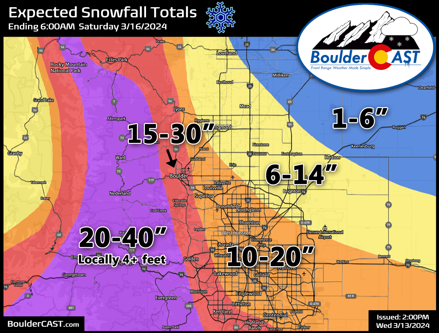
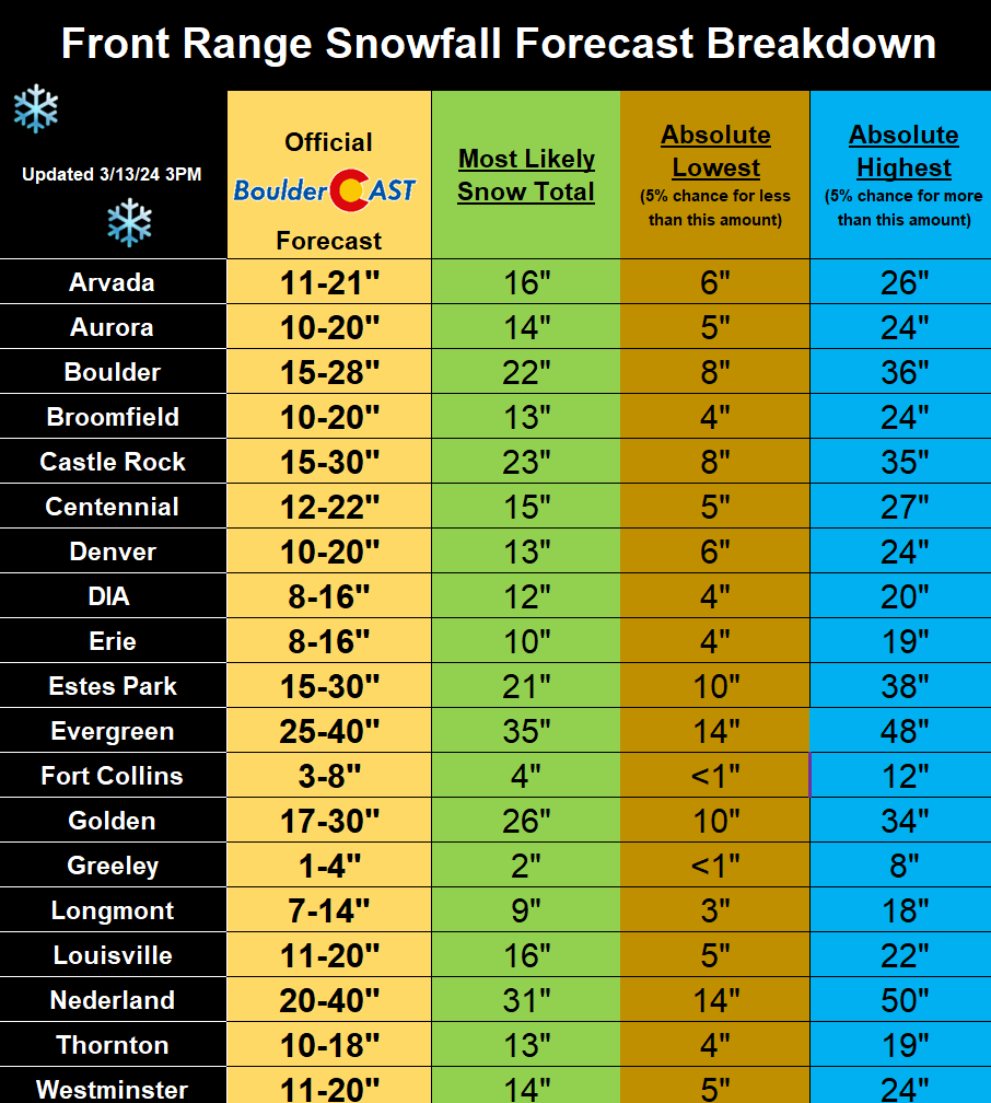
Thus, we’ve bumped up snow amounts in all areas by several more inches, pushing this storm into potential historic territory and towards crippling levels in the higher terrain. We’re now looking at 1.5 to 4 feet of snow in the Foothills (with locally up to 5 feet possible), 15 to 30″ in Boulder and the western suburbs, and 10-20″ in downtown Denver. Areas northeast remain somewhat tricky as well, but “meager” totals of less than 6″ are expected there. This includes Loveland, Greeley and Fort Collins which will be warmer and catch some downslope off the Cheyenne Ridge. Our latest snowfall forecast map issued Wednesday afternoon is shown below. Mother Nature is definitely going all-in on this storm!
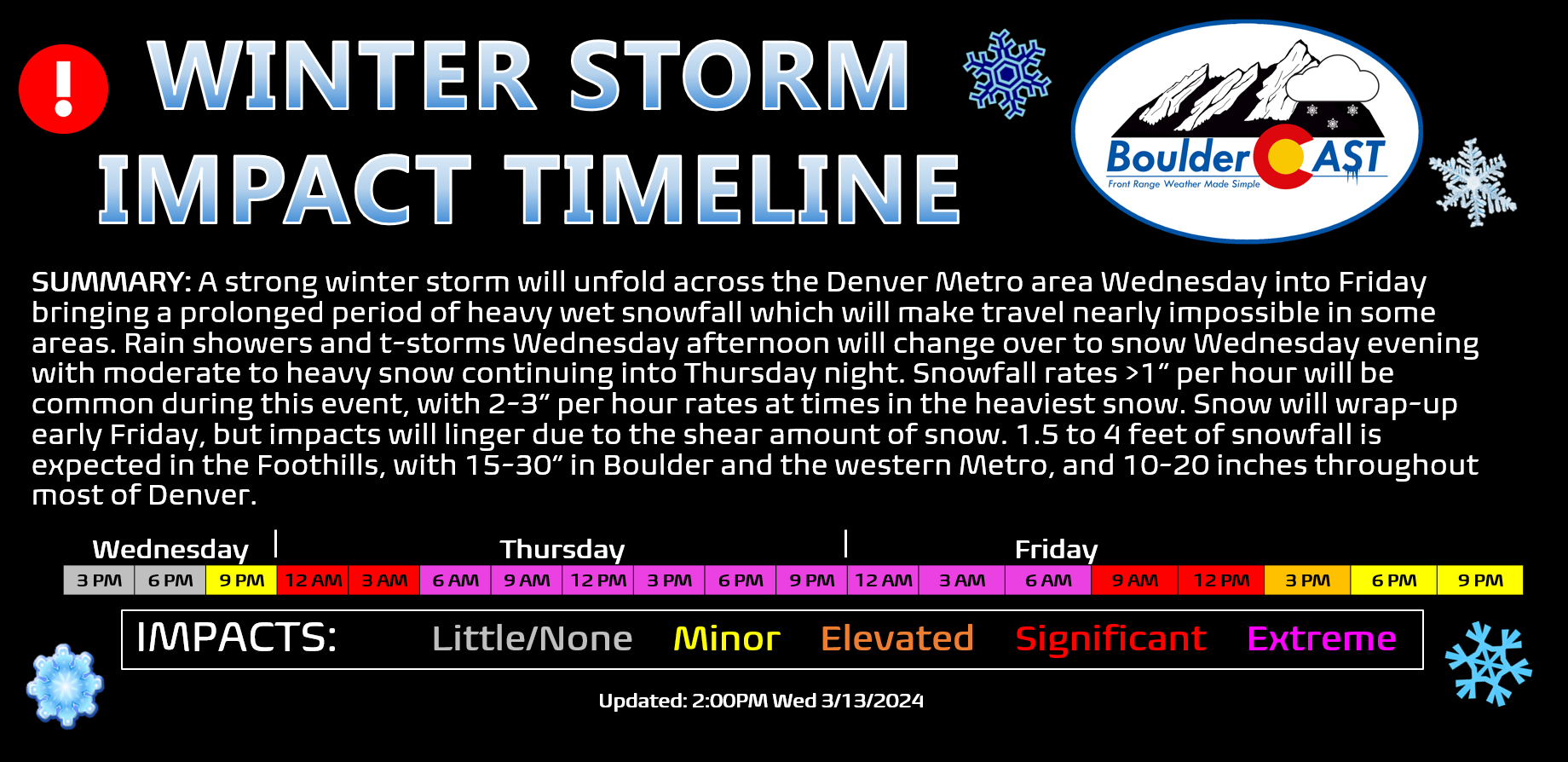
Travel will become near-impossible at times Wednesday night through Friday morning over much of the area, especially in the higher terrain where roads may stay impassable for several days following the event. Please plan on bunkering down wherever you are until things are safe and roads are cleared. Our updated winter storm impact timeline below shows when we expect the worst travel conditions resulting from hours upon hours of heavy snow and blustery northeast winds whipping everything around! And hey, we finally get to use the elusive magenta color! By the way, there’s close to zero percent chance that any flights get into or out of the Metro area on Thursday; that includes DIA. If you had a flight, you may as well try to reschedule it now.
Winter Storm Warnings are posted for the entire Denver Metro area, Foothills and Mountains— and let’s be real, a lot of Colorado! The warnings go into effect at Noon on Wednesday in the higher terrain and 9PM Wednesday evening for the lower elevations.
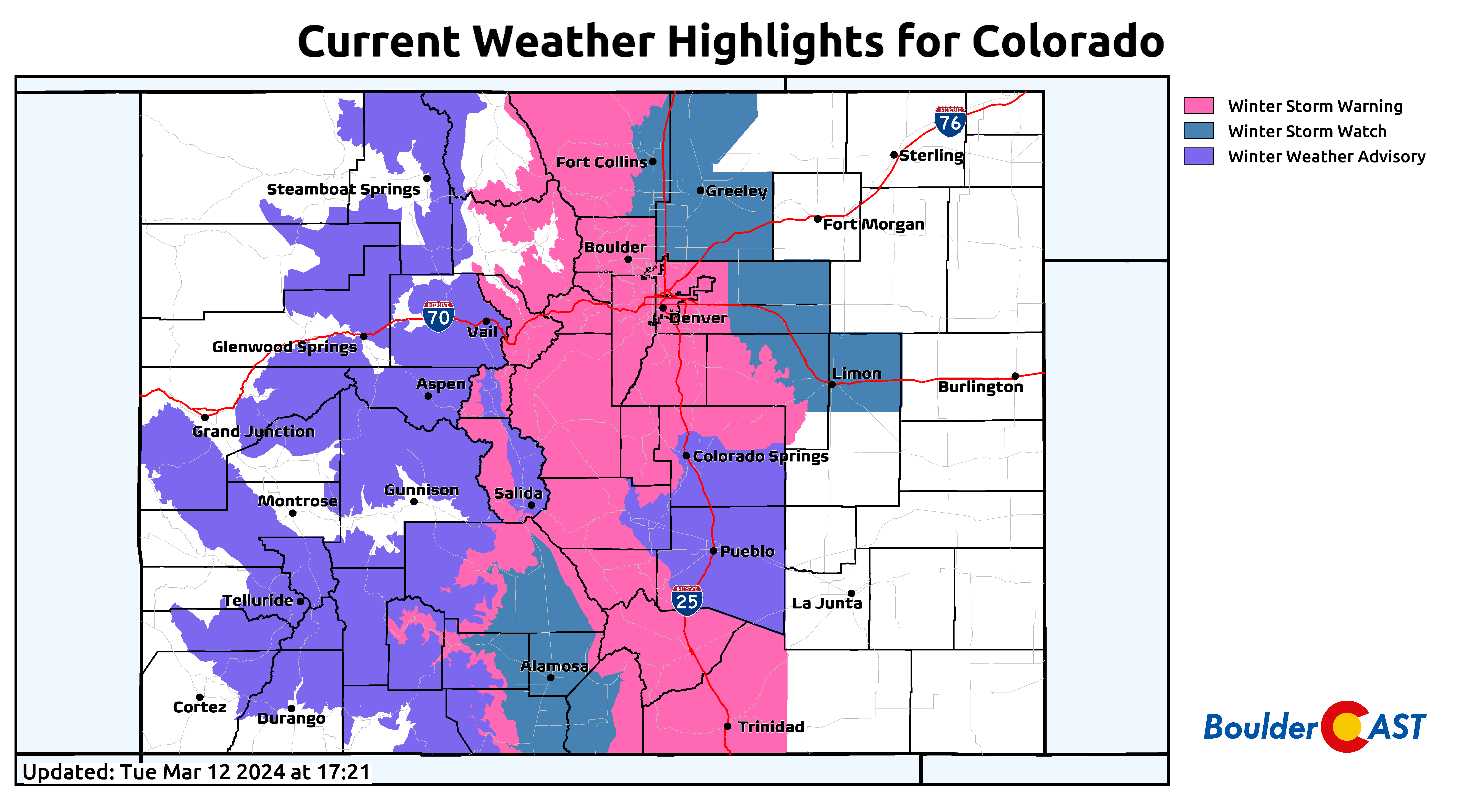
Here’s a breakdown of where things stand as of Wednesday afternoon…
CURRENT STORM TIMELINE:
- Wednesday: It’ll be dry, cold and gloomy for a chunk of the day Wednesday before scattered showers and thunderstorms break out during the afternoon and early evening, first across the higher terrain. These will be rain on the lower elevations, but snow in the higher Foothills. Some snow may mix down low as well towards sunset.
- Wednesday night: Convective showers will transition to a widespread shield of precipitation with rain changing to wet snow for everyone. The complete change-over timing looks to be between 6PM and 10PM Wednesday evening but may be earlier depending on the intensity of the precipitation. Rain will linger longest in the north/northeastern Metro area. Heavy snow will be widespread in the Foothills and much of the Metro area overnight with 1-2″ per hour snowfall rates. If things are going as planned with this storm, we should all be waking up to 4-10″ of snow by sunrise Thursday, if not more!
- Thursday: Heavy, wet snow will continue through the entire day with snowfall rates of 1-3″ per hour being common, especially if a barrier jet develops and shifts things away from the terrain. Roads will be extremely treacherous and potentially impossible to navigate in some areas, and we may see travel bans go into effect. Temperatures will remain locked at near 32°F during the day as wet snow falls, compacts and partially melts. An additional 5-12″ or more may fall during the day but it will be sloppy due to temperatures near freezing and the mid-March sun.
- Thursday night: Moderate to heavy snow will continue into the evening but should decrease in intensity as the night wears on. Light snow will linger into the morning. Another 3-9″ of snow is expected overnight.
- Friday: Snow will come to an end in the morning or perhaps early afternoon but travel will still be challenging until roads are cleared properly. This snow will be sloppy and quite the undertaking to shovel. Help out your neighbors if you are able!
BOTTOM-LINE: A MAJOR winter storm is on-track to hit the Denver Metro area and with borderline catastrophic conditions in the Front Range Foothills late Wednesday into Friday. Impacts will be widespread and extreme, especially Wednesday night into Thursday night, when travel may literally become impossible in many locations. Plan now for what is about to transpire! You still have time!
❄️SNOW POLL TIME! ☃️
How much snow do YOU think Boulder will receive from the impending winter storm system arriving late Wednesday & continuing through Friday?
FYI: 30.0"+ would be a new single storm record for the city! #COwx #Boulder #Colorado #COwx #Denver #Boulderwx
— BoulderCAST Weather 🏔️❄️ (@BoulderCAST) March 13, 2024
Finally, we know you all just love our snowfall forecast table — this one’s gonna be a doozy!
We’ll keep you updated as this intense unfold over the next 48 hours. In the end, this may make the short list of largest snowstorms after all! Stay tuned, stay subscribed, but most importantly, stay safe! And good luck to our Foothills’ friends!

Get BoulderCAST updates delivered to your inbox:
Go Premium, get all the perks.
Daily Forecast Updates
Get our daily forecast discussion every morning delivered to your inbox.
All Our Model Data
Access to all our Colorado-centric high-resolution weather model graphics. Seriously — every one!
Ski & Hiking Forecasts
6-day forecasts for all the Colorado ski resorts, plus more than 120 hiking trails, including every 14er.
Smoke Forecasts
Wildfire smoke concentration predictions up to 72 hours into the future.
Exclusive Content
Weekend outlooks every Thursday, bonus storm updates, historical data and much more!
No Advertisements
Enjoy ad-free viewing on the entire site.
Enjoy our content? Help us out and give it a share:


I’m very excited.
Thanks for emphasizing how difficult travel will be. We’ll be skipping our regular Thursday skiing in favor of Monday
I’m also quite excited, if you couldn’t tell. Skipping the ski trip is probably a good idea. Not sure where you would go, but it seems highly likely I-70 west will shut down Wednesday late afternoon and may not reopen until Friday!