After a solid dump of springtime snow Sunday night, including widespread thundersnow, things will turn quiet for the week ahead with temperatures trending from downright chilly back to t-shirt weather by week’s end. We recap last night’s snowstorm, check the snowfall totals, and detail the Front Range forecast for the next seven days. Let’s dive in!
This week’s highlights include:
- Storm Recap: The Denver Metro area experienced a brief but intense snowstorm on Sunday night, characterized by thundersnow and heavy snowfall rates of 1-3 inches per hour in some areas. The storm brought a rapid temperature drop from the 50s to the 20s, resulting in decent snow accumulation for the area.
- Snowfall Totals: Snow totals varied across the region, with 1 inch reported around Greeley and up to 11 inches near Genesee and Evergreen. Officially, Boulder recorded 6.1 inches, while Denver (DIA) saw 3.2 inches. The BoulderCAST forecast verified quite well, though there were a few booming totals.
- Weekly Forecast: The upcoming week is expected to be quiet with temperatures gradually warming up. After the snow ends on Monday morning, the rest of the week will see a transition from chilly conditions to t-shirt weather!
DISCLAIMER: This weekly outlook forecast is created Monday morning and covers the entire upcoming week. Accuracy will decrease as the week progresses as this post is NOT updated. To receive daily updated forecasts from our team, among many other perks, subscribe to BoulderCAST Premium.

Go Premium, get all the perks.
Daily Forecast Updates
Get our daily forecast discussion every morning delivered to your inbox.
All Our Model Data
Access to all our Colorado-centric high-resolution weather model graphics. Seriously — every one!
Ski & Hiking Forecasts
6-day forecasts for all the Colorado ski resorts, plus more than 120 hiking trails, including every 14er.
Smoke Forecasts
Wildfire smoke concentration predictions up to 72 hours into the future.
Exclusive Content
Weekend outlooks every Thursday, bonus storm updates, historical data and much more!
No Advertisements
Enjoy ad-free viewing on the entire site.
Storm Recap: T-storms transitioned quickly to snow Sunday evening!
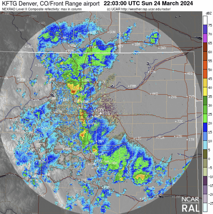
Thunderstorms started popping late Sunday afternoon and quickly transitioned to heavy snow across the Denver Metro area by early evening. As expected, the overnight storm only offered a brief six-hour window for moderate to heavy snowfall in our area before the strong low pressure moved too far away which switched on the downslope over the Boulder area around midnight Sunday night. This brought snowfall coverage and intensity down considerably, though very light snow still continues as of sunrise on Monday.
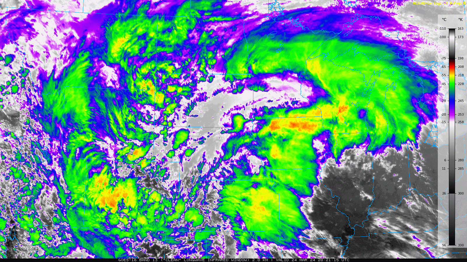
The GOES-East infrared satellite animation below captures the entire snow event from space. Initially there was deep convection over the Front Range (orange cloud tops in the animation), but that didn’t last more than a couple hours.
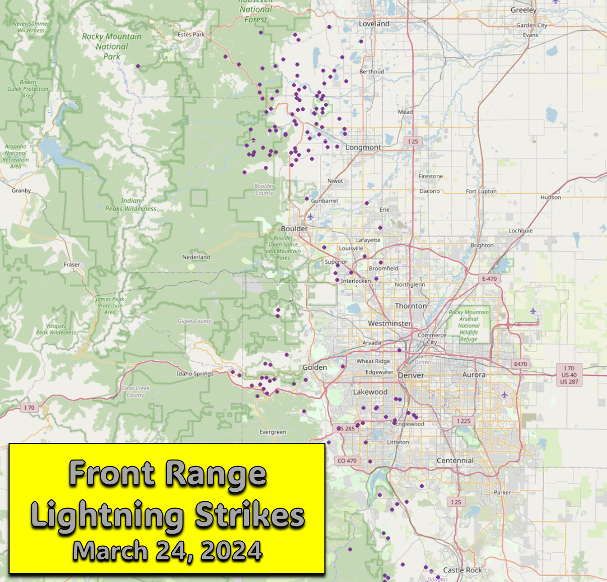
This springtime instability resulted in numerous reports of small hail in addition to more than 100 lightning strikes across the Front Range Sunday evening, our most convective day of nascent 2024. The lightning map below shows that every detected rumble of thunder occurred west of Interstate 25!
The initial burst of convection really helped to drag our temperatures down allowing for a rapid change-over from rain to snow between 5 and 6PM Sunday evening. Before the storms, temperatures were in the low to middle 50s. As thunder and heavy rain unleashed, our temperatures dropped quickly into the 30s. The timeline below shows the temperature and weather from Sunday at our station.
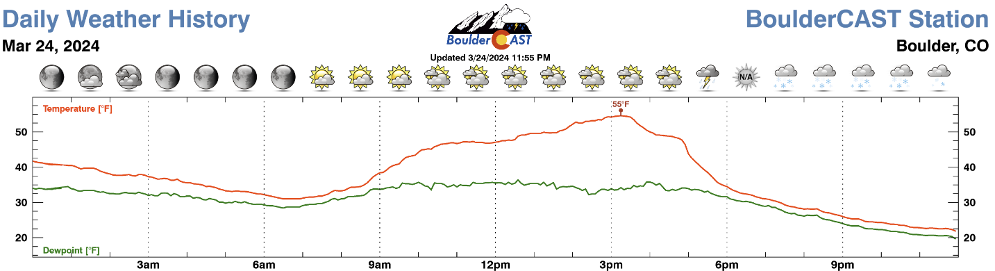
The odd “N/A” weather symbol above is present because we don’t have the logic setup properly to handle thundersnow, and that’s exactly what was happening around 6:00 PM Sunday evening! Last night is probably the most widespread occurrence of thundersnow I can remember, though there’s a clear difference between a thunder(rain)storm mixing/changing to snow compared to having thunder during the middle of an especially dynamic snowstorm. Both are technically thundersnow, but the latter is definitely more impressive and rare.
⚡️❄️Snowflakes are falling in #Boulder and it's also thundering, but is it thundersnow? We'll allow it! #COWx
— BoulderCAST Weather 🏔️❄️ (@BoulderCAST) March 24, 2024
The early convective rain and thundersnow quickly transitioned to an all-snow event, with heavy snowfall rates of 1-3″ per hour hammering areas in and near the Foothills at times Sunday evening. There was a lot of melting initially, though, with roadways holding out for hours before becoming snow-covered late Sunday evening.
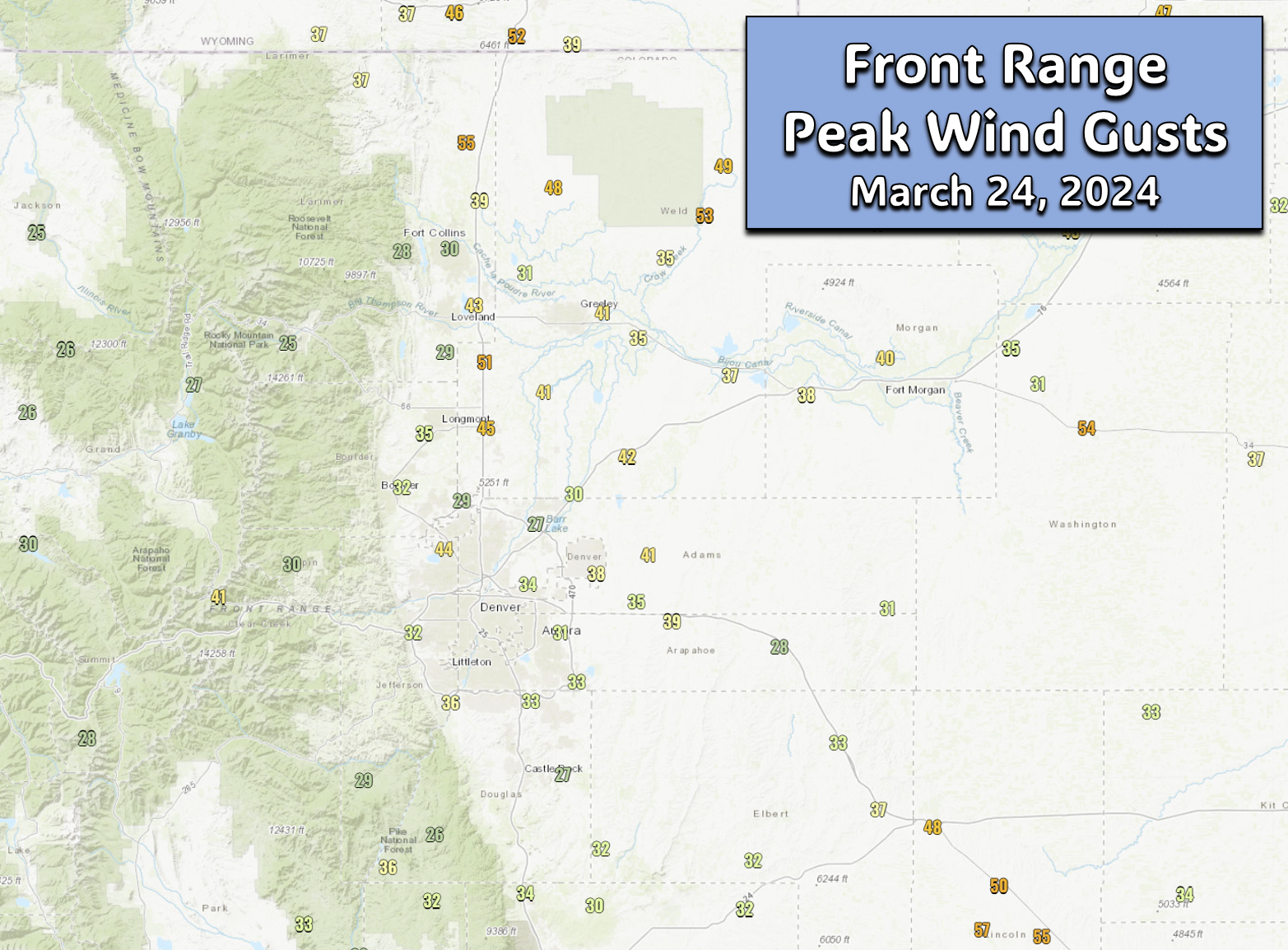
The initial cold front and thunderstorm that blew in brought wind gusts around 40 MPH to Boulder, but winds thereafter were generally below 25 MPH and thus blowing snow was minimal. There was certainly some drifting at times, but nothing too bad and nothing bordering on blizzard-like.
There was a lone 40 MPH wind gust earlier as the initial thunderstorm outflow/cold front blew into #Boulder. It's been blustery, but the worst of the wind will fortunately stay east of I-25 tonight. #COWx pic.twitter.com/UY7cWsiLH1
— BoulderCAST Weather 🏔️❄️ (@BoulderCAST) March 25, 2024
Wind gusts across the Metro area on Sunday were similar, with generally most cities seeing 25 to 45 MPH peak gusts.
As upslope turned to downslope Sunday night, snow began to quickly decrease in coverage and intensity, especially from Boulder northward to Fort Collins, while the heavier snow shifted off the east a bit. The full 12-hour radar loop from the storm is shown below. Can you pick out the commencement of downslope wind into Boulder/Larimer counties? We bet you can!
Our snowfall forecast map issued Sunday morning for the event is shown below with actual storm totals overlaid. Green values indicate our forecast verified to within one inch. Red did not. Snow totals ranged from 1″ around Greeley to 11″ near Genesee and Evergreen. Our forecast turned out pretty good across most of the Metro area and nearby Foothills. Some northern locations between Longmont, Lyons and Berthoud did boom beyond our forecast by a couple inches, owing to a few hours of locally heavy snow late Sunday evening.
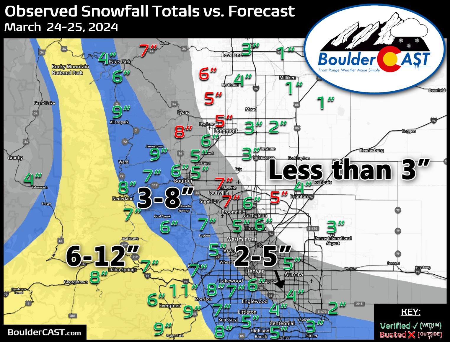
Officially Boulder reported 6.1″ of snow from the storm, while Denver (DIA) recorded 3.2″. We measured 5.8″ at our location.
Storm total is 5.8"… Slushy at the bottom, but fluffy on top! #cowx #boulderwx pic.twitter.com/LuQR7M5S8E
— BoulderCAST Weather 🏔️❄️ (@BoulderCAST) March 25, 2024
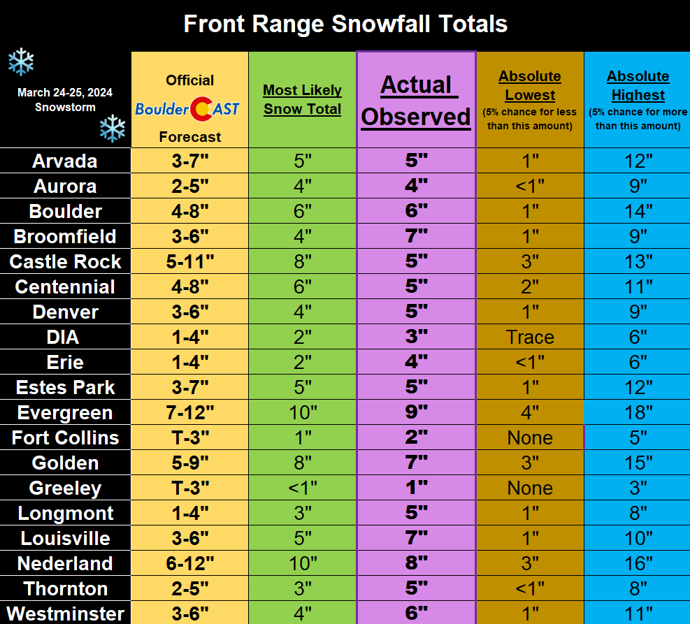
Finally, here is how things shook out for select cities across the Front Range:
The week ahead: Largely quiet with moderating temperatures
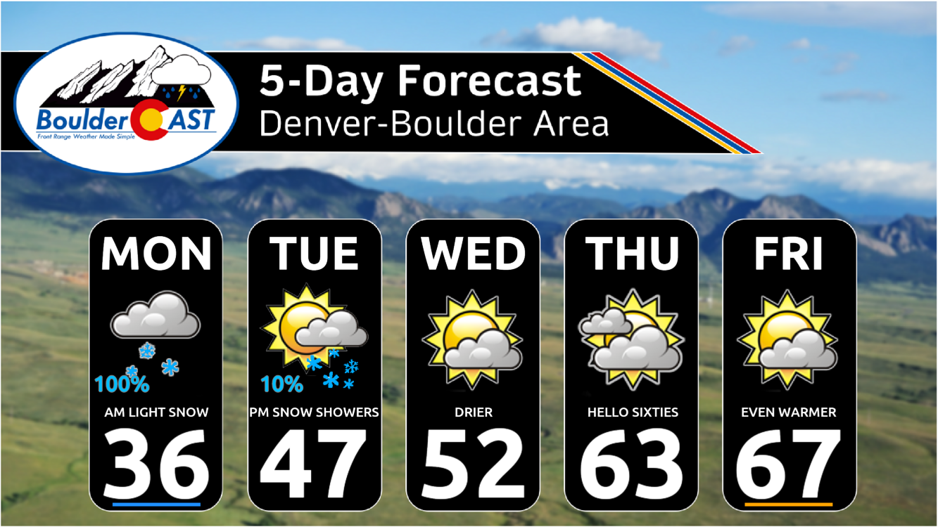
After the snow comes to an end on Monday morning, the rest of the week will largely be quiet across the Front Range.
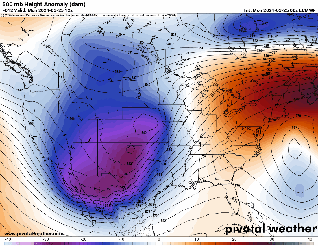
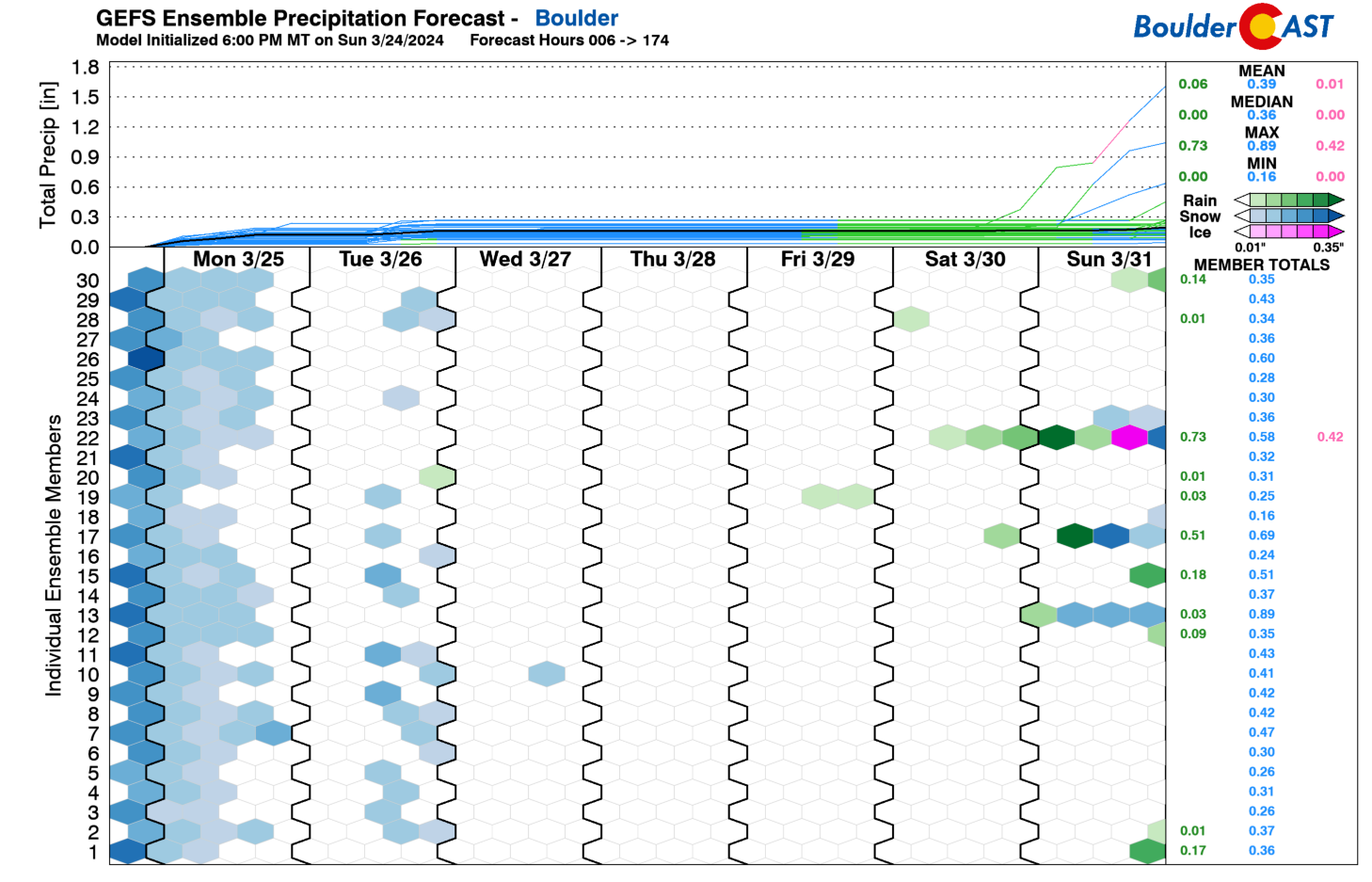
Monday’s low pressure system will scoot off into the Upper Midwest by Tuesday, but the broader trough will linger over Colorado for a few more days into Wednesday. Northwest flow will setup over the area through the first few days of the week, with lingering embedded moisture spawning a few popcorn snow showers at times in the Mountains and Foothills, while the lower elevations remain mostly dry but chilly. There is a slight chance of a late-day snow shower in the Metro area Tuesday, but no accumulation is expected with highs in the 40s. Beginning on Thursday, a shortwave ridge will enter the picture from the west and that will stick around into at least part of the weekend. Eventually late in the upcoming weekend another storm system is set to come ashore into California but that one remains uncertain at this time. It may stall out or track quite far south — time will tell.
Thursday into the weekend will feature notably warmer temperatures and possibly elevated fire danger at times as southwesterly downslope flow ramps up across all of eastern Colorado. It’s too early to make a definitive call on fire risk, though, as conditions are marginal for our area (but appear more dangerous for southeast Colorado). For now, plan on temperatures returning to the 50s by Wednesday and then into the 60s Thursday and Friday.
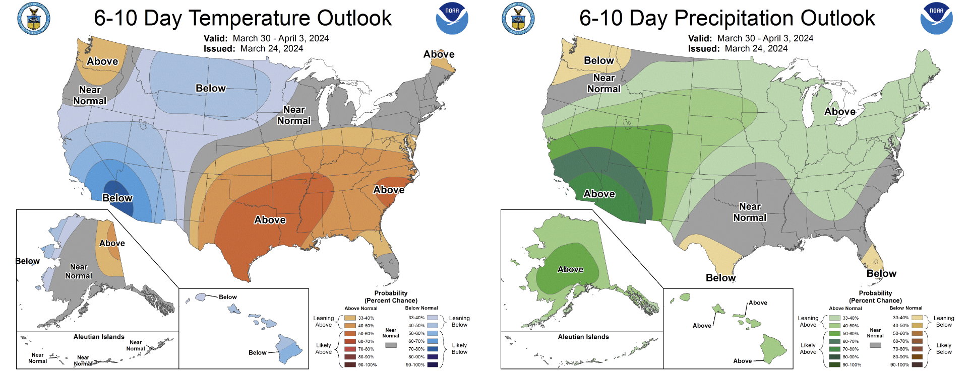
While the upcoming weekend looks to stay warm and mostly dry for the area, the next trough will be approaching around Sunday into early next week with a return of cooler and unsettled weather for much of the Desert Southwest and southern Rockies expected eventually. The Climate Prediction Center is favoring cooler and wetter than normal conditions for the Front Range early next week due to this incoming trough.
Enjoy the relative calm in our weather this week! We will be back to t-shirt weather in no time!
Get BoulderCAST updates delivered to your inbox:
Forecast Specifics:
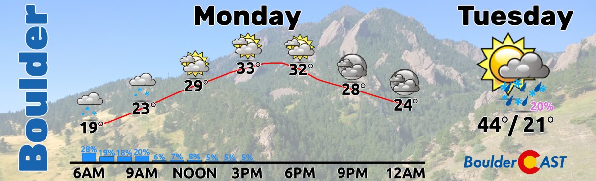
Monday: Light snow lingers in the morning across the area with a dusting or less of additional accumulation. Skies remain mostly cloudy through the day with cold temperatures. Highs top out in the middle 30s on the Plains with upper 20s in the Foothills. Wind chills in the single digits and teens will make for a cold morning!
Tuesday: Partly to mostly cloudy with a slight chance of a late-day show shower, mainly in the Foothills. Highs return to the middle 40s on the Plains with middle 30s in the Foothills.
Wednesday: Partly cloudy and somewhat mild with isolated snow showers in the Foothills. We stay dry on the lower elevations. Temperatures top out in the lower 50s on the Plains with lower 40s in the Foothills.
Thursday: Partly to mostly cloudy but notably warmer as a ridge builds into the area. Highs reach the lower to middle 60s on the Plains with near 50 in the Foothills.
Friday: Partly cloudy and continued warm. It may be breezy with elevated fire danger. Temperatures top out in the middle 60s on the Plains with lower 50s in the Foothills.
DISCLAIMER: This weekly outlook forecast is created Monday morning and covers the entire upcoming week. Accuracy will decrease as the week progresses as this post is NOT updated. To receive daily updated forecasts from our team, among many other perks, subscribe to BoulderCAST Premium.
Go Premium, get all the perks.
Daily Forecast Updates
Get our daily forecast discussion every morning delivered to your inbox.
All Our Model Data
Access to all our Colorado-centric high-resolution weather model graphics. Seriously — every one!
Ski & Hiking Forecasts
6-day forecasts for all the Colorado ski resorts, plus more than 120 hiking trails, including every 14er.
Smoke Forecasts
Wildfire smoke concentration predictions up to 72 hours into the future.
Exclusive Content
Weekend outlooks every Thursday, bonus storm updates, historical data and much more!
No Advertisements
Enjoy ad-free viewing on the entire site.
Enjoy our content? Give it a share!


You must be logged in to post a comment.