El Niño has yet to deliver any major storms to the Front Range this winter season but that could change heading into the first week or two of January as a more active southern storm track takes shape across western North America. Several systems will bring snow to Colorado, though the focus appears to be across the southern tier of the state rather than the Front Range. We discuss the notably variable forecast for the week ahead including several chances for snow in the extended.
This week’s highlights include:
- For the first time this winter, the southern storm track looks to be gearing up with a pipeline of storms set to hit the southwestern USA this week and next
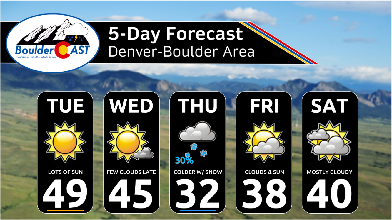
- 2024 begins quiet in the Front Range with mild temperatures and plenty of sunshine Tuesday and Wednesday
- A closed low will move across New Mexico on Thursday but most of the impacts will be south of Denver unfortunately
- Colder temperatures Thursday with a chance of light accumulating snow, mainly for the southern and eastern burbs
- Staying cool but dry Friday into Saturday between storm systems
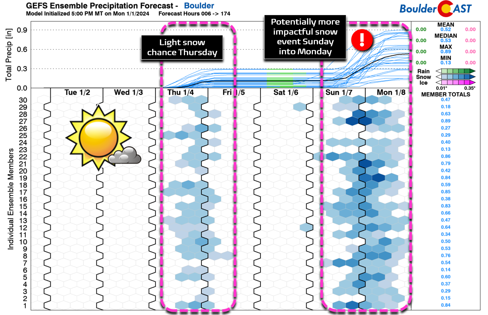
- Another, potentially stronger southern-track storm will bring a chance of snow late Sunday or Monday of next week — still uncertain but bears a close watch
DISCLAIMER: This weekly outlook forecast is created Monday morning and covers the entire upcoming week. Accuracy will decrease as the week progresses as this post is NOT updated. To receive daily updated forecasts from our team, among many other perks, subscribe to BoulderCAST Premium.

Go Premium, get all the perks.
Daily Forecast Updates
Get our daily forecast discussion every morning delivered to your inbox.
All Our Model Data
Access to all our Colorado-centric high-resolution weather model graphics. Seriously — every one!
Ski & Hiking Forecasts
6-day forecasts for all the Colorado ski resorts, plus more than 120 hiking trails, including every 14er.
Smoke Forecasts
Wildfire smoke concentration predictions up to 72 hours into the future.
Exclusive Content
Weekend outlooks every Thursday, bonus storm updates, historical data and much more!
No Advertisements
Enjoy ad-free viewing on the entire site.
A pair of dry & seasonal days Tuesday into Wednesday
We hope you had yet another lovely holiday weekend ringing in the New Year! 2024 will begin with more of the same rather boring weather we’ve been used to over the last few months — but only for the first couple days. The extended forecast is showing promising signs of turning more active, especially the southern tier storm track which is typically a staple of El Niño winter seasons. We’ve had a few one-off southern-track storms already this winter, but this broader pattern has never persisted and hasn’t delivered any major precipitation events for us so far. Things may be about to change though, especially as we head into next week. We have not just one, but TWO snow events on the horizon. More on these in a moment…
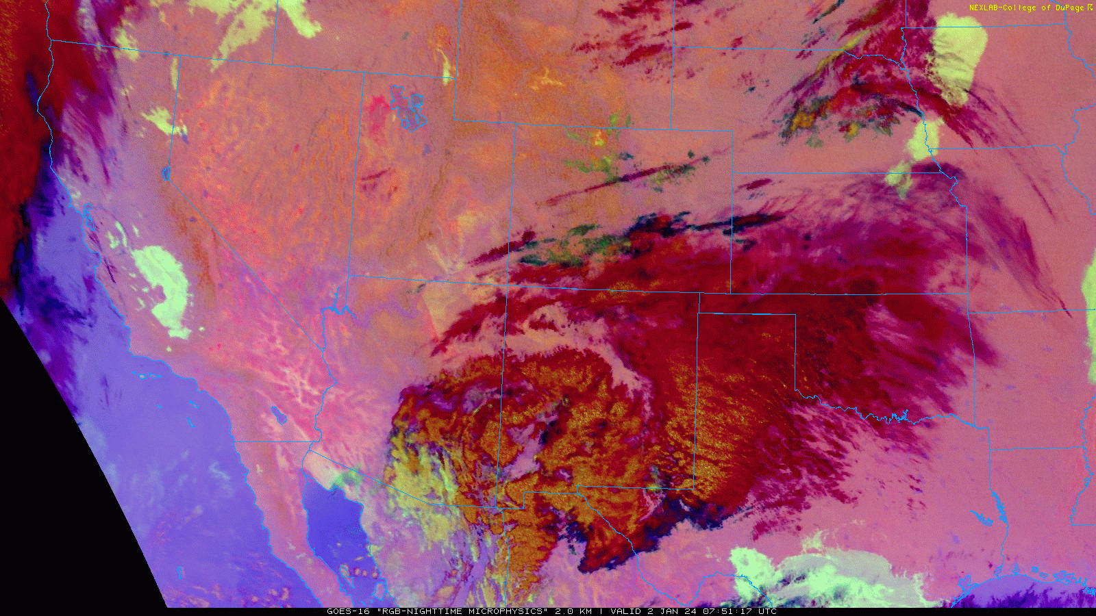
As of writing Tuesday morning, a weak upper-level low pressure is tracking through the Desert along the Mexican Border. Widespread clouds and some precipitation are noted to our south, but this system is too small and too far away to bring any real impacts to the Front Range. There were just a few clouds overnight but those have dissipated before sunrise.
Skies will remain conclusively sunny throughout our Tuesday with temperatures just above seasonal normals topping out in the upper 40s to lower 50s.
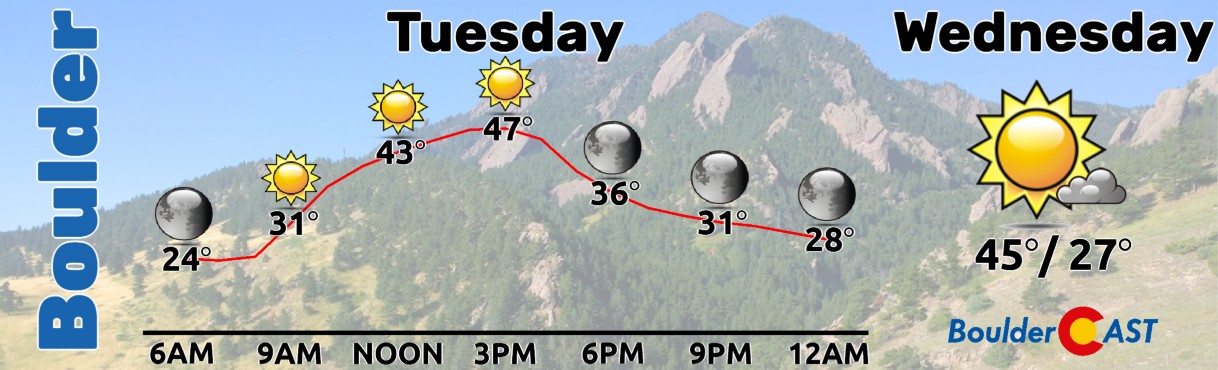
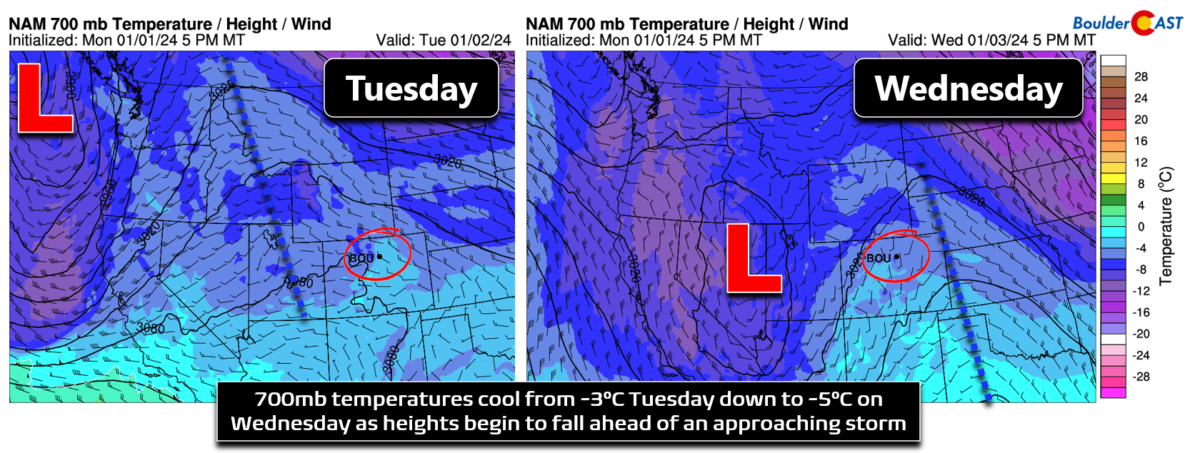
Wednesday will offer almost identical conditions, though temperatures will be a few degrees cooler. Despite a ridge axis pushing into the area and its associated southwest flow, heights will be falling ahead of an approaching southern-track storm diving into the Desert Southwest — this one will eventually be our (light) snow-maker for Thursday. Temperatures aloft will cool by about 2°C from Tuesday into Wednesday over the Front Range, also noted as a weak frontal boundary moving in Wednesday morning. All in all, Wednesday should remain mostly sunny for us but temperatures will be a tad cooler in the middle 40s.
Late week the southern storm track turns more active
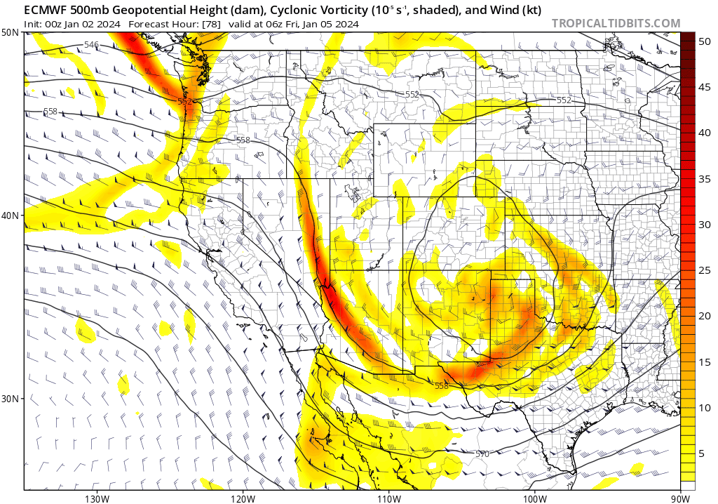
By Thursday, we will start to see the broader pattern shift happening across western North America as our first notable southern-track storm system arrives to the region. Initially this system breaks off from the polar jet stream on Wednesday before passing across northern New Mexico on Thursday. North of this closed-low pressure, winds will turn easterly providing a deeper upslope component to much of the Centennial State.
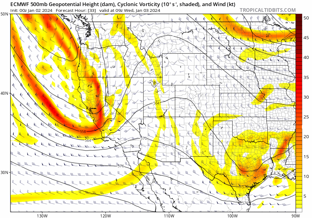
Euro 500mb vorticity forecast animation Tuesday into Thursday night showing the approaching storm which dives into New Mexico
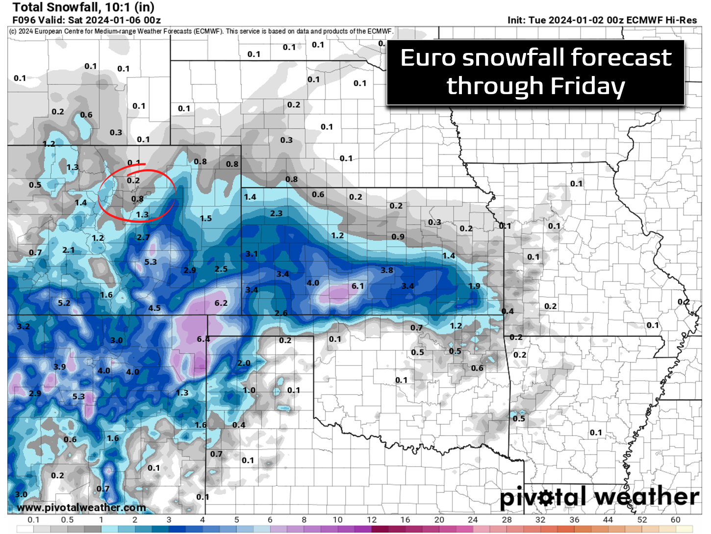
However, let’s not get too excited — the track of the storm, combined with its somewhat petite size, will keep most of the snowy impacts across southern Colorado and New Mexico. The precipitation forecast below is the average prediction from the 50 European ensemble members. This shows only light precipitation in the Front Range through Friday morning, with southern areas of Denver and the Palmer Divide likely to see more precipitation than Boulder or Fort Collins.
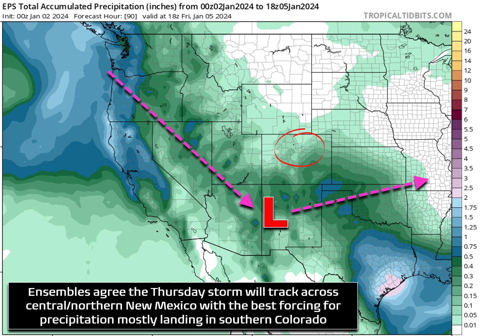
As of writing, we are only expecting light snow for the Denver Metro area from this system Thursday evening as things mainly develop across southern Colorado and the far eastern Plains. It will definitely be a cloudy and much colder day following a cold front, but most of us should see 2″ or less of snow, with perhaps not much at all developing north of Interstate 70. The best chance to see 1-2″ of accumulation is southeast of Denver.
As the first storm departs into the southern Plains on Friday, skies will clear partially but only briefly ahead of yet another southern-track shortwave. This one will scoot across the Four Corners on Saturday bringing mostly just cloud cover to the region. Temperatures will remain cool both Friday and Saturday with highs below normal in the middle 30s to lower 40s.
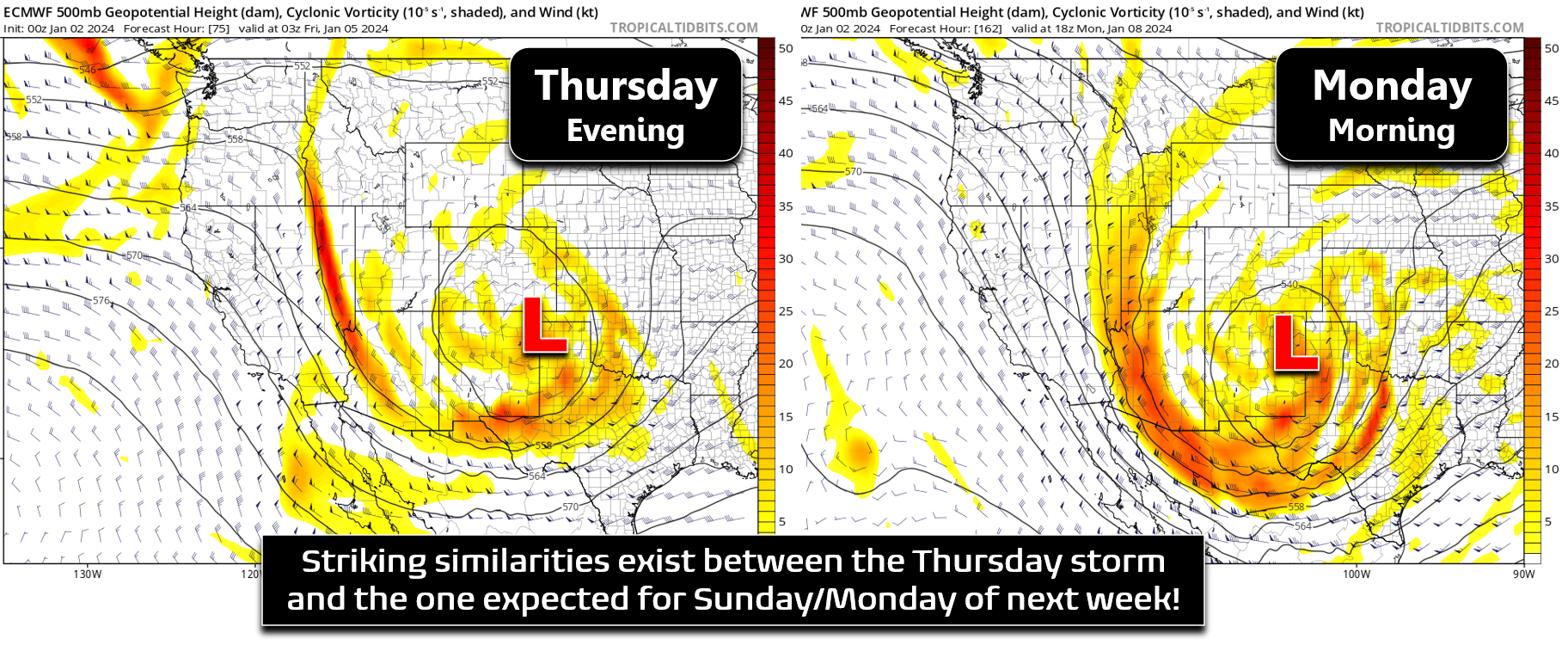
Euro 500mb vorticity forecast animation from Thursday into Monday. The onslaught of southern-track storms will continue!
The more interesting weather feature, though still far out, is the one that arrives around the Sunday or Monday timeframe (January 7th into the 8th). In almost identical fashion, another cut-off low pressure is progged to break off from the polar jet and dive into the Four Corners area, with an eventual track across northern New Mexico. Sound familiar? This path would once again favor southern Colorado and New Mexico — and not so much the Front Range. However, this encore storm is shown to be stronger and would likely have a larger sphere of influence with more favorable upslope reaching into our area, even if the track is not ideal.
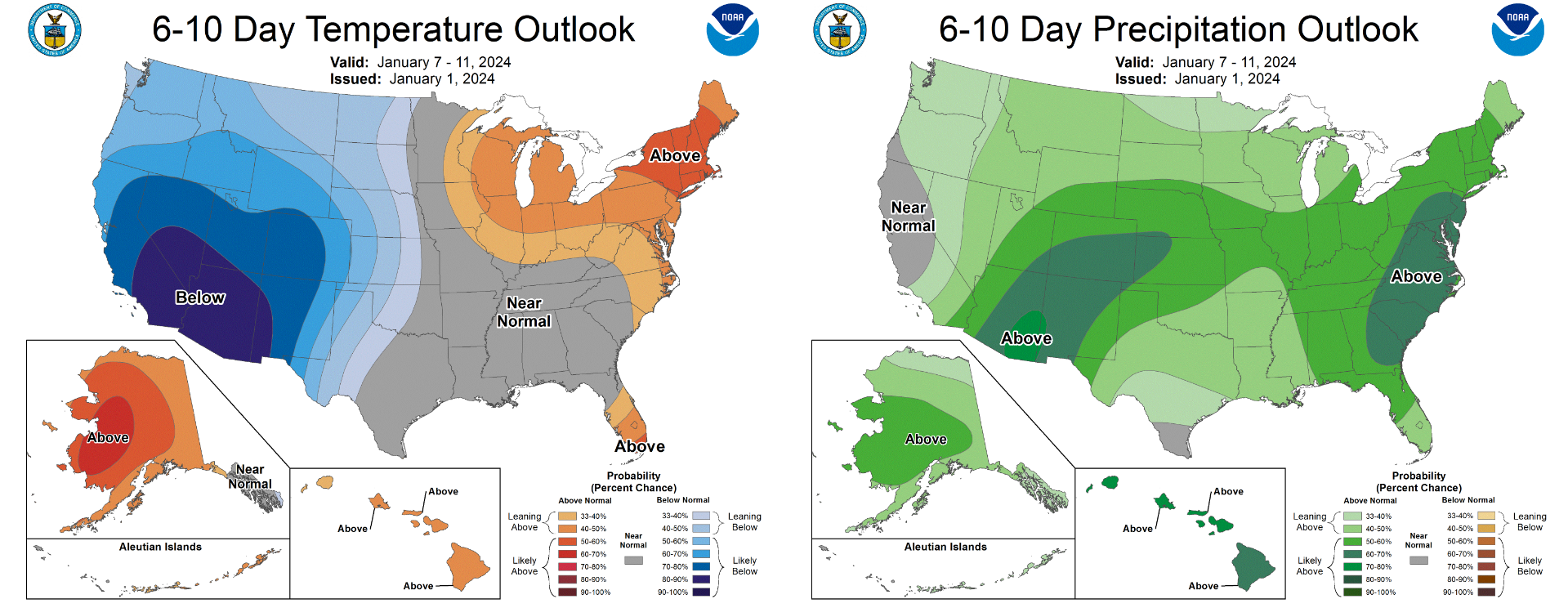
While still five to six days out, ensembles are in fairly good agreement for where and when this storm will move Sunday into Monday. This lead time leaves a broad window for further track shifts which may boost or hurt our snowfall chances from the system. As of writing though, ensembles are pointing towards a 2-5″ snow event being the most likely outcome early next week. Take that with a lump of salt. For what it’s worth, the Climate Prediction Center indicates a strong probability for a swath of above normal precipitation in the Southwest next week. This is in part due to the Monday storm which does indeed look promising, but also yet another system which may pass through around midweek.
That’s all for now. We’ll keep you updated on the developing light snow chance for Thursday and the parallel one taking shape for early next week. Enjoy the weather!
Get BoulderCAST updates delivered to your inbox:
Forecast Specifics:
Tuesday: Sunny and mild with high temperatures around 50 degrees on the Plains with upper 30s on the Foothills.
Wednesday:A sunny day with just a few clouds arriving towards sunset. Highs a tad cooler in the middle 40s on the Plains with middle 30s in the Foothills.
Thursday: Much colder with temperatures topping out only in the lower 30s. Overcast skies with flurries possible during the day and potentially light accumulating snow in the evening and overnight. A trace to 2″ of snow is expected with the highest totals southeast of Denver.
Friday: A mix of clouds and sunshine with perhaps a few lingering flakes in the morning hours. Temperatures remain chilly with highs in the middle to upper 30s on the Plains with upper 20s in the Foothills.
Saturday: Lots of clouds but we should remain dry as a weak system passes to our south. Highs will reach near 40 degrees on the Plains but near 30 degrees in the Foothills.
DISCLAIMER: This weekly outlook forecast is created Monday morning and covers the entire upcoming week. Accuracy will decrease as the week progresses as this post is NOT updated. To receive daily updated forecasts from our team, among many other perks, subscribe to BoulderCAST Premium.
Go Premium, get all the perks.
Daily Forecast Updates
Get our daily forecast discussion every morning delivered to your inbox.
All Our Model Data
Access to all our Colorado-centric high-resolution weather model graphics. Seriously — every one!
Ski & Hiking Forecasts
6-day forecasts for all the Colorado ski resorts, plus more than 120 hiking trails, including every 14er.
Smoke Forecasts
Wildfire smoke concentration predictions up to 72 hours into the future.
Exclusive Content
Weekend outlooks every Thursday, bonus storm updates, historical data and much more!
No Advertisements
Enjoy ad-free viewing on the entire site.
Enjoy our content? Give it a share!


You must be logged in to post a comment.