After several mild and beautiful February days, winter is entering right back into the forecast. The first southern-track storm of the season will aid in producing a smattering of wintry weather on Wednesday including much colder temperatures, patchy freezing drizzle and several inches of accumulating snow. Let’s take a look at the atmospheric setup, timing of the first flakes, potential commute impacts, and our snowfall forecast map.
Premium Storm Update (2/16/22 7:00AM): Overnight model runs have increased our confidence that higher-end snow totals will occur with this system. Thus we are bumping up snow amounts a tad across the area. We discuss the latest from six different models and the updated timeline for snow beginning Wednesday afternoon. READ HERE
At a Glance:
- Tuesday will be the last mild and pleasant day as our next storm system is gearing up to the west
- A weak cold front will move in late Tuesday evening, but it will be starved of moisture initially
- Low clouds and isolated freezing drizzle possible Wednesday morning into the afternoon before a change-over to snow occurs
- A surge of efficient and deep upslope will bring snow to the entire area Wednesday late afternoon into the overnight
- Possible impacts to the Wednesday evening commute as light to moderate snow develops across the area right in that timeframe
- Snow wraps up from north to south before sunrise on Thursday
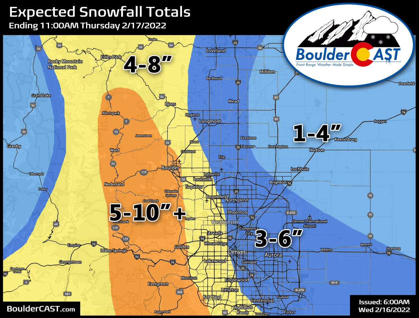
- Total snow accumulations of 5-10″ in Boulder and the Foothills, with 3-7″ in Denver
We discuss Boulder and Denver weather every single day on BoulderCAST Premium. Sign up today to get access to our daily forecast discussions every morning, complete six-day skiing and hiking forecasts powered by machine learning, access to all our Front Range specific weather models, additional storm updates and much more!

W
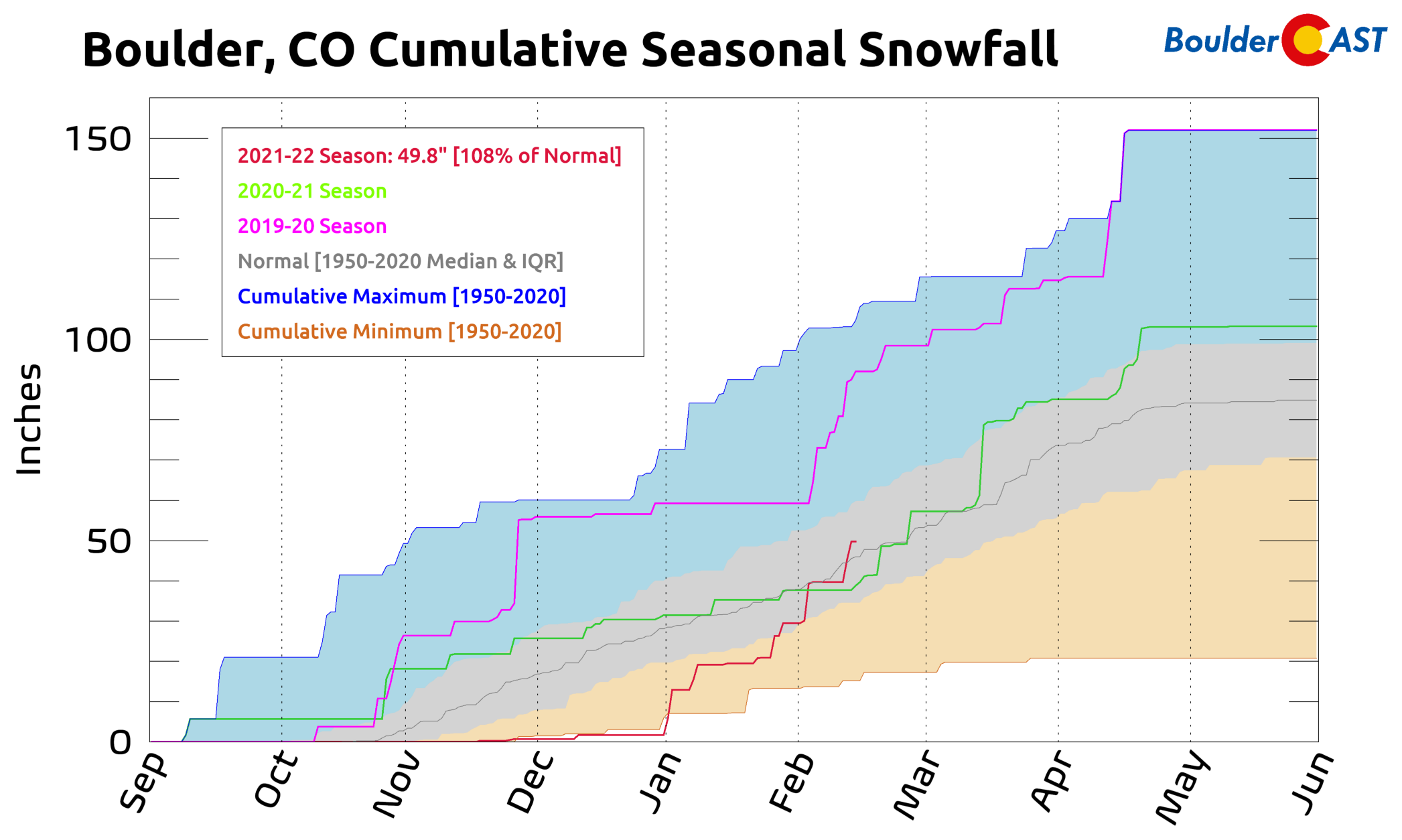
e hope you’ve been able to get outside and enjoy some of the nicer weather over the last several days. As you already know from our weekly outlook posted yesterday, the weather is about to turn — at least for a couple of days. It sure has snowed a lot recently across our area. Since New Year’s Eve, Boulder has received more than four feet of snow making a triumphant comeback from the absolute least snowiest season on record to one currently sporting above normal snowfall over just the last six weeks.
However, for the first time this winter season, a southern-track low pressure system will play a substantial part in the production of snowfall across the Front Range with this week’s snowstorm. The primary low pressure center is currently located across southern California as of Tuesday afternoon (see below).
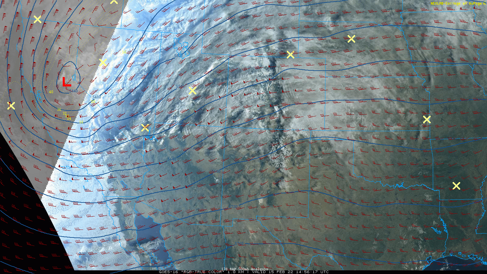
GOES-East geocolor satellite animation from Tuesday afternoon with overlaid 500mb winds and heights.
This spinning low will take a track eastward across northern Arizona and New Mexico through the day Wednesday into Wednesday night leading to enhanced upslope across the Denver Metro area.
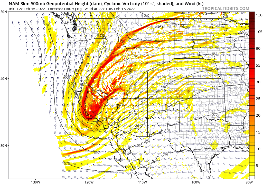
NAM-NEST 500mb height and vorticity forecast animation for Tuesday into Thursday. Watch as the California low sweeps eastward and across New Mexico
The initial shift in our weather begins late Tuesday evening with the passage of an initially dry cold front from the northeast. It should reach the Denver area a few hours after sunset but before midnight.
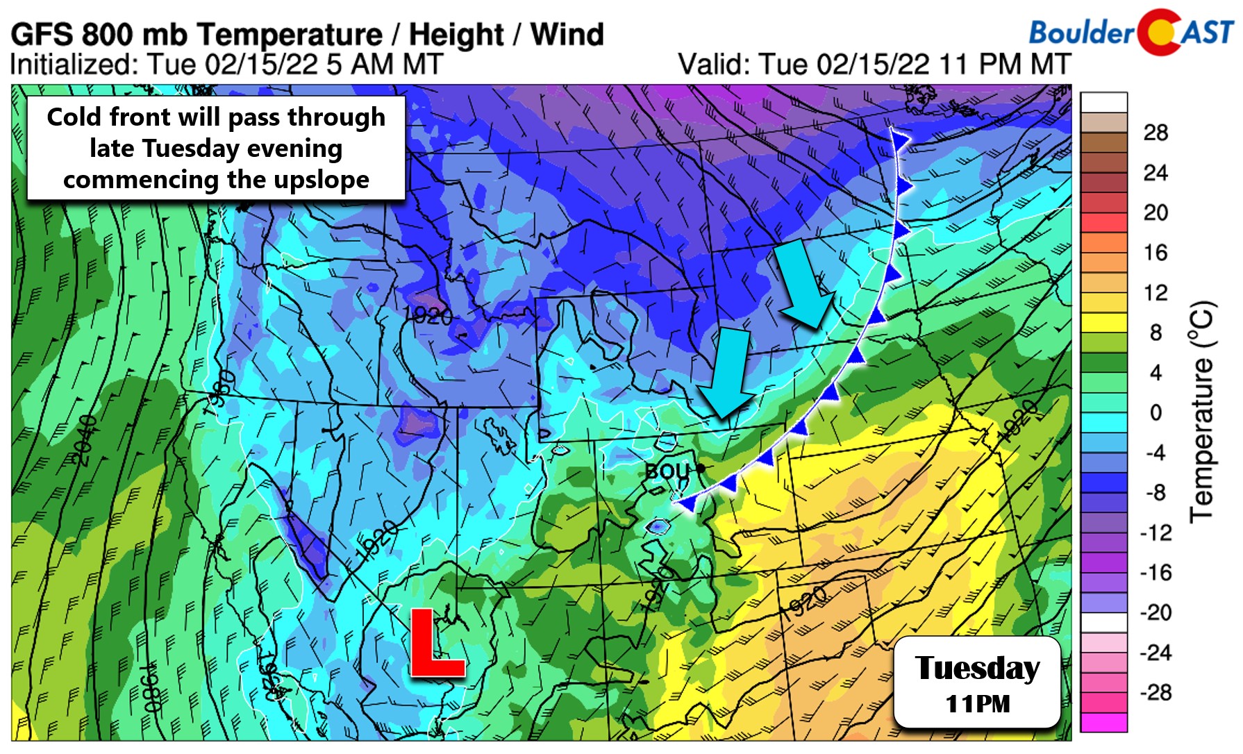
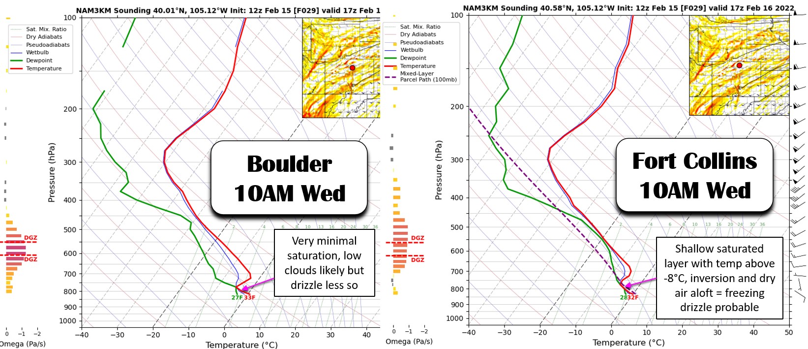
There is very limited moisture behind this front initially, but the continued upslope will work to slowly saturate the lower atmosphere overnight. It seems that this saturation may take quite a while, especially in the immediate Denver area. However, during the morning to midday hours on Wednesday, a shallow layer below ~8000 feet elevation will eventually saturate enough to possibly produce isolated freezing drizzle across the area. This is most likely to occur north of Longmont towards Fort Collins where moisture depth will be greater. While low clouds are guaranteed early Wednesday, the freezing drizzle threat is low in Boulder and almost non-existent in southern Denver. Just be careful for a chance of a light glaze of ice on Wednesday before the snow commences! Temperatures will stay near or slightly below freezing during the day.
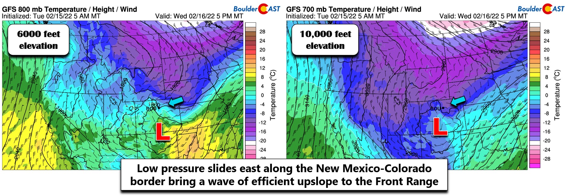
Eventually the aforementioned low pressure system scooting across the Four Corners region will move into its position across the Colorado-New Mexico border Wednesday afternoon into the evening. This will bring a surge of stronger upslope to the area alongside a period of upper-level forcing as well. During this window, any lingering mixed precipitation will transition to all snow and that snowfall will encompass much of the area. As you can see in the two panels below, upslope direction will be almost due easterly for a short time during the early evening on Wednesday. This should really help to enhance snowfall rates in and near the Foothills with brief moderate snowfall possible. The best ingredients for snow remain in place from late afternoon until about midnight, with snow expected to taper off from north to south before sunrise Thursday.
It’s worth noting that despite models having a solid beat on this snow event for nearly a week now, they have struggled with the timing considerably. In all cases, the arrival of the snow has been pushed back over and over again. While models originally showed the snow starting Tuesday afternoon, it’s now primarily starting 24 hours later on Wednesday afternoon and this delay has continued to increase with the recent model runs as well. This has actually helped to remove one of the forecasting challenges with this system — the somewhat warm daytime temperatures causing falling snow to melt. With the later start, the sun will be low in the sky or set completely when a bulk of the snow will be falling, aiding in more accumulation.
In regards to snowfall amounts, were generally expecting this to be a 2 to 6″ type of event for the Denver area with higher totals possible across the Foothills and western/southwestern suburbs including Boulder. As usual, the focus towards the terrain results from the importance of upslope to this event and the colder temperatures up there (higher snow ratios!). Our latest snowfall probabilities derived from a plethora of various model sources seem to have a good grasp on the event. As is normal in these scenarios, Boulder has the greatest chance of a “significant” snow total.
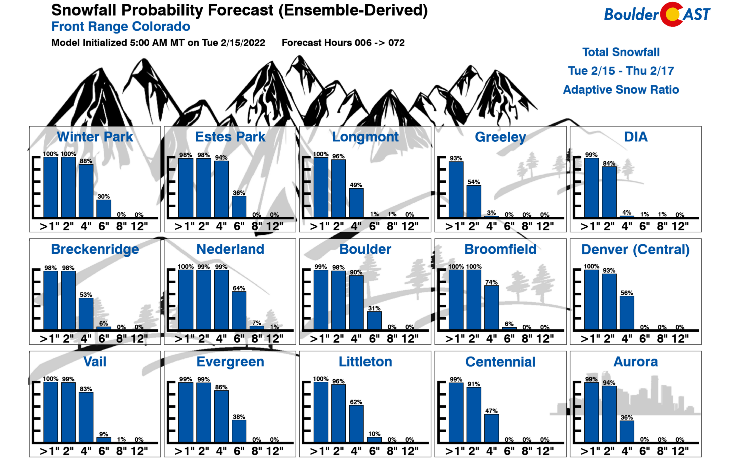
Our snowfall forecast map for the event is shown below (updated on 2/16/21 6:00AM). This covers all of the snow falling through Thursday morning. Due to the anticipated uptick in snow during the late afternoon and evening timeframe on Wednesday, we do expect impacts to the evening commute. Leave work a little early if you can!
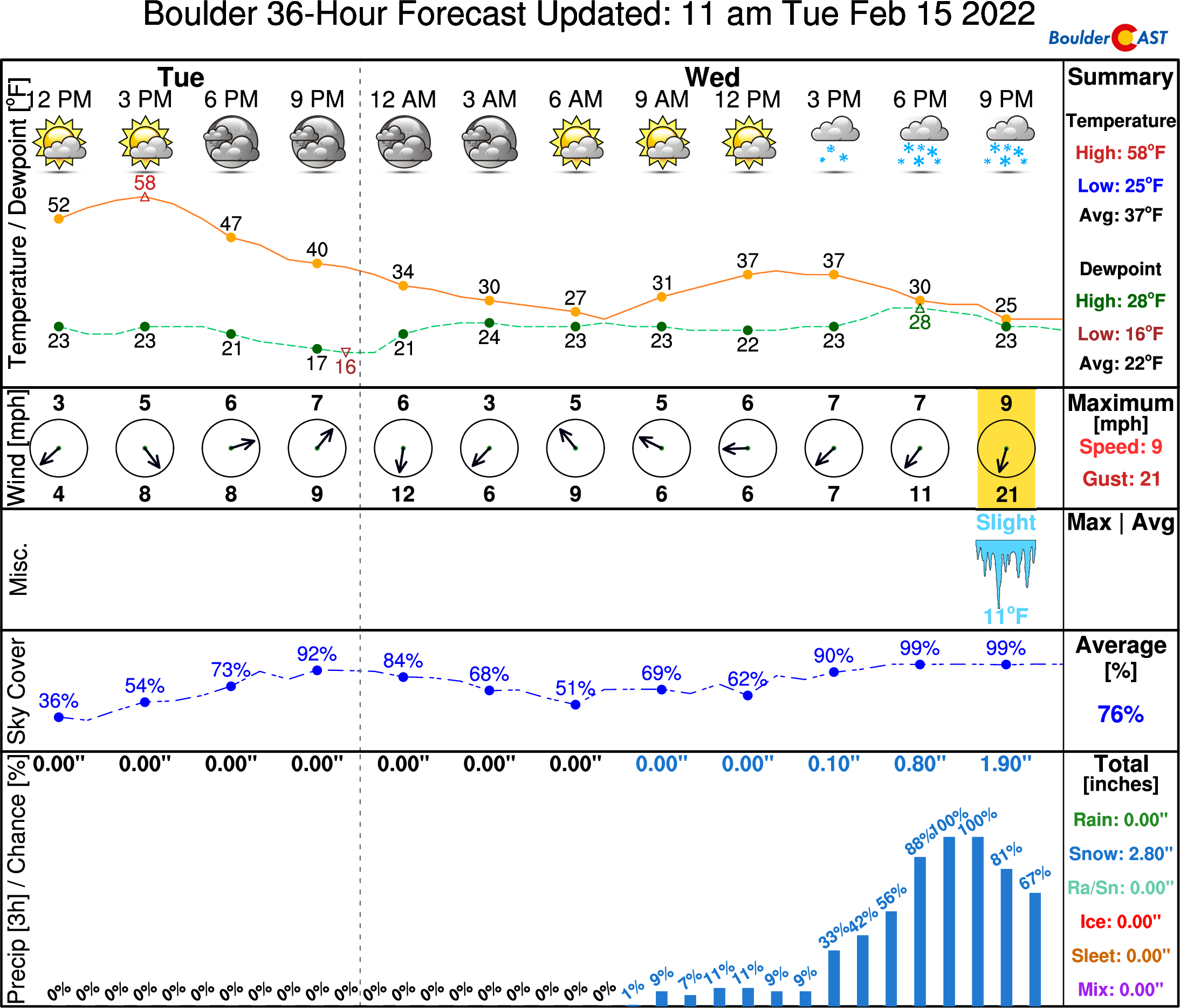
Here’s the latest NowCAST timeline forecast for Boulder:
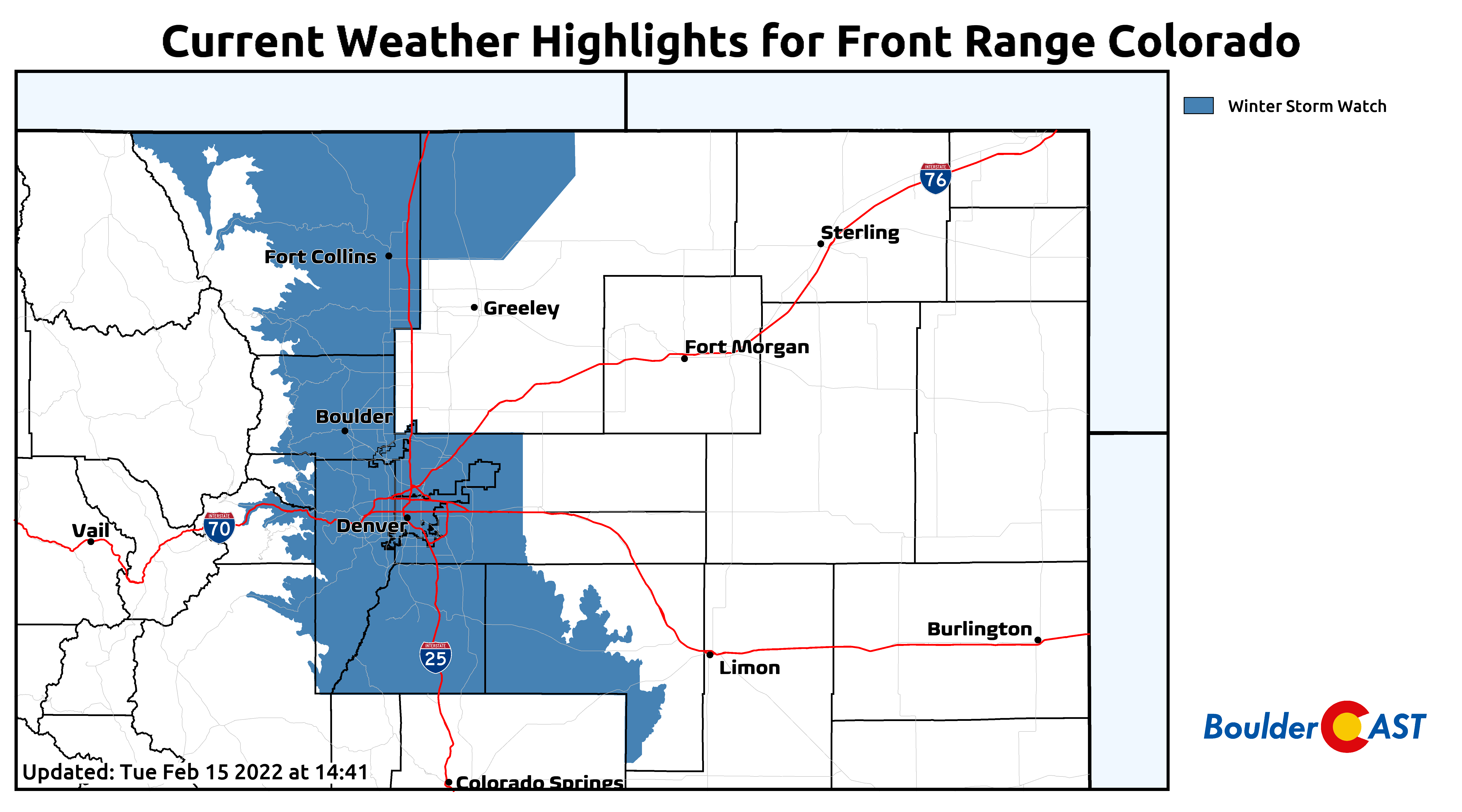
As of writing, Winter Storm Watches have been posted for the Denver Metro area, the Foothills, and the Palmer Divide. Early Wednesday morning these will either get upgraded to a Winter Storm Warning or downgraded to a Winter Weather Advisory.
We may put out a tweaked snowfall forecast map early Wednesday if things look drastically different as we start getting a better look at this storm in the short-range models. Stay tuned and stay subscribed…
Get BoulderCAST updates delivered to your inbox:
Help support our team of Front Range weather bloggers by joining BoulderCAST Premium. We talk Boulder and Denver weather every single day. Sign up now to get access to our daily forecast discussions each morning, complete six-day skiing and hiking forecasts powered by machine learning, first-class access to all our Colorado-centric high-resolution weather graphics, bonus storm updates and much more! Or not, we just appreciate your readership!
Enjoy our content? Give it a share!


You must be logged in to post a comment.