Wildfire smoke roared into the Front Range late Thursday night like a freight train — well if those were somehow silent and made up of tiny cancer-causing particles! Air quality and visibility have both tanked across the entire Denver Metro area as a result. Yuck! We discuss where all this smoke is coming from and when it may actually clear out.
Unhealthy for Everyone!
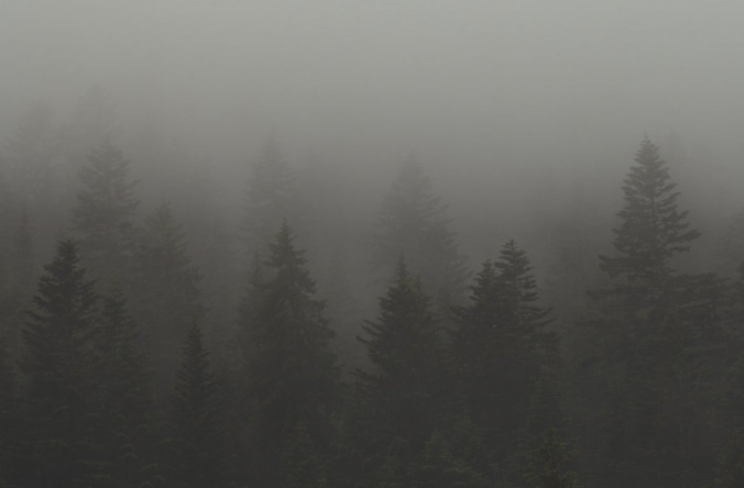
Extremely thick wildfire smoke has surged into the Front Range overnight. The view of our iconic Flatirons from downtown Boulder is anything but magnificent today:

This smoke was of course in the forecast and was something we’ve been talking about since at least Wednesday when it became very apparent that smoke would reach eastern Colorado behind an approaching cold front. Our station’s air quality sensor shows that the smoke arrived around 1:30AM Friday morning when the PM2.5 Air Quality Index immediately rose from Good to Unhealthy. This overnight timing meant many folks may have awoken Friday morning to dry eyes, sore throats and headaches due to the fine particulates in the air if windows were left open.

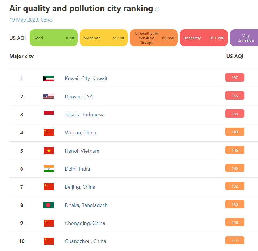
The air quality is so bad today here that Denver is ranked #2 on IQAir’s list of the world’s worst (instantaneous) air quality among major cities — just behind Kuwait City (plagued by pollution for the oil industry) and just ahead of most notoriously polluted Asian cities. Let that one sink in…
Following the Front Range’s biggest rain event since the Great 2013 Flood, which was just last week, it’s hard to imagine wildfire smoke being a problem for us right now isn’t it, especially this being our verifiably wettest time of year? However, as we have seen so many times in years prior, our local fire and drought situation is only part of the equation factoring in to our regional air quality. In past summers, smoke from California, Oregon, Arizona, and even Canada have tanked our air quality at times. Who remembers Smokeggedon back in August 2021?

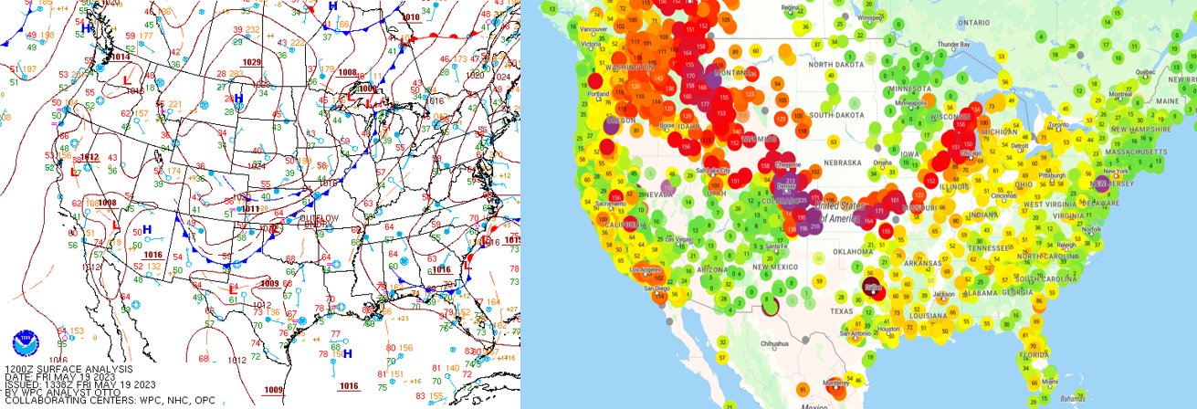
It’s important to mention that our area is not alone in breathing terrible air today, though it is arguably the worst here. Smoky air is observed all along a cold front sweeping across the nation right now — from the Great Lakes, westward across the Midwest, and northward across the heart of the Rockies. Converging winds along the front is helping to further concentrate the smoke.
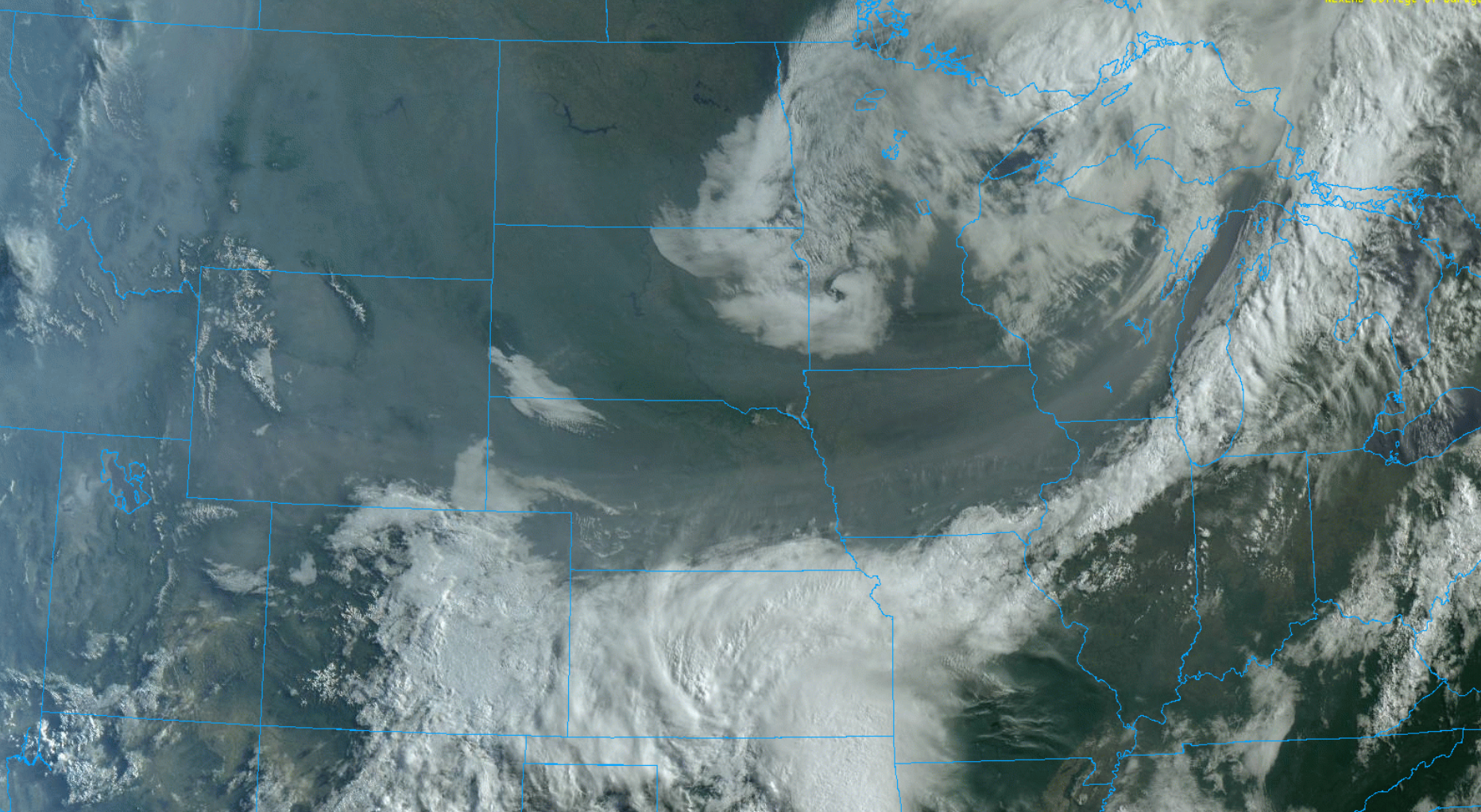
The smoke across the nation was very apparent from space this morning — this beautiful imagery below is from GOES-East. Note that smoke is a lot more visible from space when the sun is low in the sky (due to the complexities of scattering sunlight). That ghostly line moving across the animation from east to west is close to where sunrise is happening.
So what is the source region for the thick smoke this time? Our wonderful neighbors to the north in Canada! There are currently dozens of massive and out of control wildfires burning across remote areas of British Columbia, Alberta and Saskatchewan.

This region of Canada has been suffering from months of widespread drought which has preconditioned the vegetation to burn. The climate and landscape up there is not all that different than here in Colorado — it is mostly evergreen forests in the Canadian Rockies with arid prairie to the east. When it’s dry, and when there is an ignition source (cult rituals or otherwise), it burns.
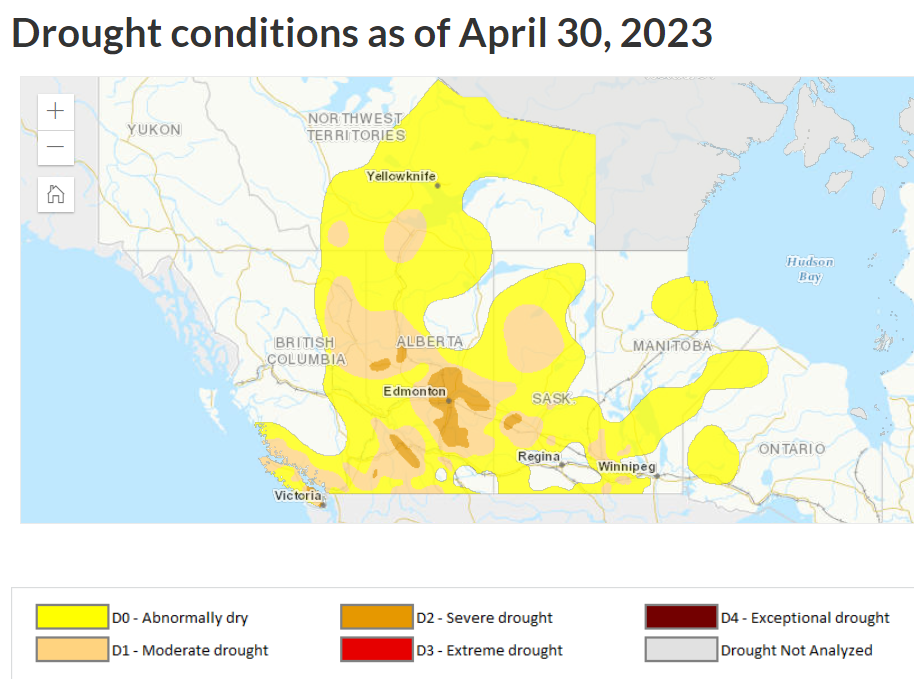
Many of these fires blew up during that huge “Omega Block” pattern across North America back in early May which brough record warmth and low humidity to Canada, with slower winds allowing the smoke to pool over central Canada as well.

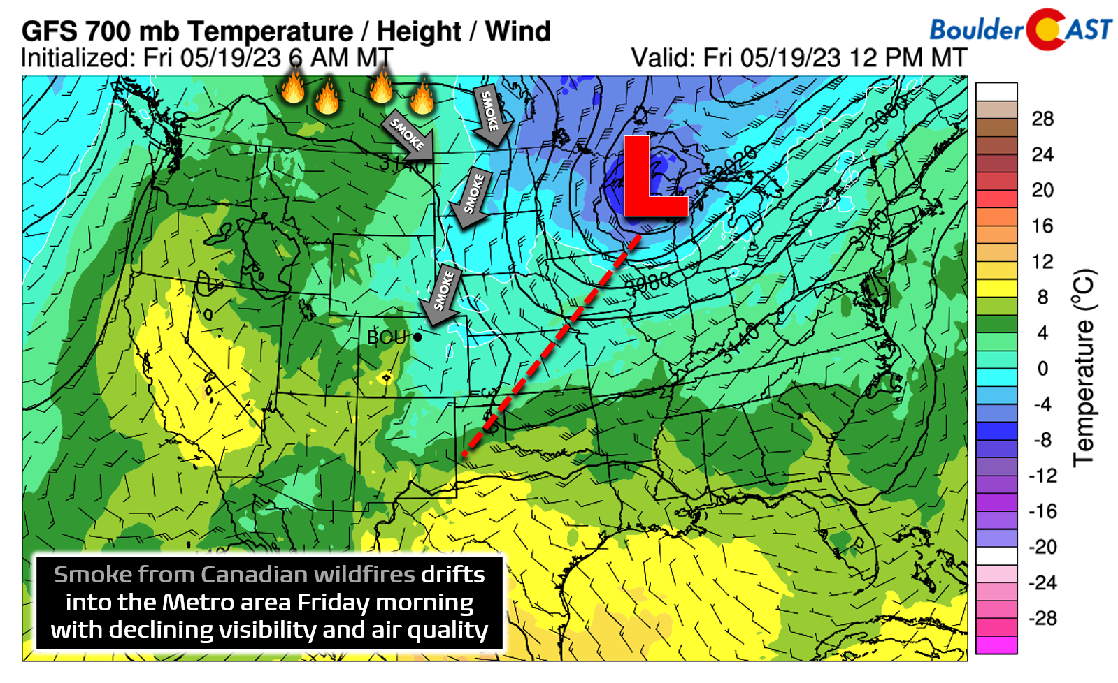
The smoke is coming into eastern Colorado today behind a cold front, which in addition to the smoke, ushered in upslope, low clouds, and some drizzle in spots. We like to use forecast winds at 700mb to predict smoke transport from distant fires — this level is at approximately 10,000 feet elevation, though sometimes other levels can be useful depending on the situation. Today’s 700mb forecast map is shown below. It’s clear based on the winds how the smoke arrived to the Front Range from fires burning more than 1000 miles to our north. We can blame that sharp trough over the Great Lakes!
The good news is that the thickest smoke in the Denver Metro area won’t last too long this time. According to the handful of smoke-prediction models, some viewable over on our Colorado Smoke Forecast page, the smoke will be the absolute worst on Friday, but it should begin to clear up by Saturday afternoon, possibly earlier for parts of the southern Metro and Palmer Divide. It doesn’t look like the smoke will entirely vacate the area though, even by Sunday, with some amount of lingering haze staying the course across much of Colorado. In reality, those big and plentiful wildfires in Canada won’t be going away any time soon. Every time there is a decent cold front or a trough developing over the Great Lakes turning winds northerly in the center of the USA, more smoke will likely return to the Front Range.

Go Premium, get all the perks.
Daily Forecast Updates
Get our daily forecast discussion every morning delivered to your inbox.
All Our Model Data
Access to all our Colorado-centric high-resolution weather model graphics. Seriously — every one!
Ski & Hiking Forecasts
6-day forecasts for all the Colorado ski resorts, plus more than 120 hiking trails, including every 14er.
Smoke Forecasts
Wildfire smoke concentration predictions up to 72 hours into the future.
Exclusive Content
Weekend outlooks every Thursday, bonus storm updates, historical data and much more!
No Advertisements
Enjoy ad-free viewing on the entire site.
Get BoulderCAST updates delivered to your inbox:
Enjoy our content? Give it a share!


You must be logged in to post a comment.