Following month after month of dry and warm weather, December finally turned the tide and brought colder and snowier conditions to the region. Will January continue the trend? Read on as we examine Boulder’s climatology and consider the current state of the atmosphere to give our outlook for the next month.
—
This content was exclusively available to BoulderCAST Premium subscribers until January 3, 2017. Learn more about joining BoulderCAST Premium below:

Get extra perks and help support BoulderCAST!
A look back at December
The second half of 2016 was one of the warmest and driest on record for the Front Range. However, during the last month, we finally saw our weather turn sharply colder and snowier. While the first half of December had several cold air outbreaks, the latter half was largely dominated by seasonal temperatures and dry downslope for the lower elevations.
Boulder concluded the month of December with a temperature ~2 degrees below normal (Denver was ~2 degrees below normal as well). We saw a few 60-degree afternoons, as well as few mornings with sub-zero temperatures during the month. For precipitation, Boulder ended the month with 0.91″ of liquid precipitation (0.78″ in Denver). This is right at normal for Boulder, and well above normal for Denver. Contained in that liquid was 13.0″ of snow, just below our normal of 14″.
The maps below outline December’s temperature (left) and precipitation (right) anomalies for the state.
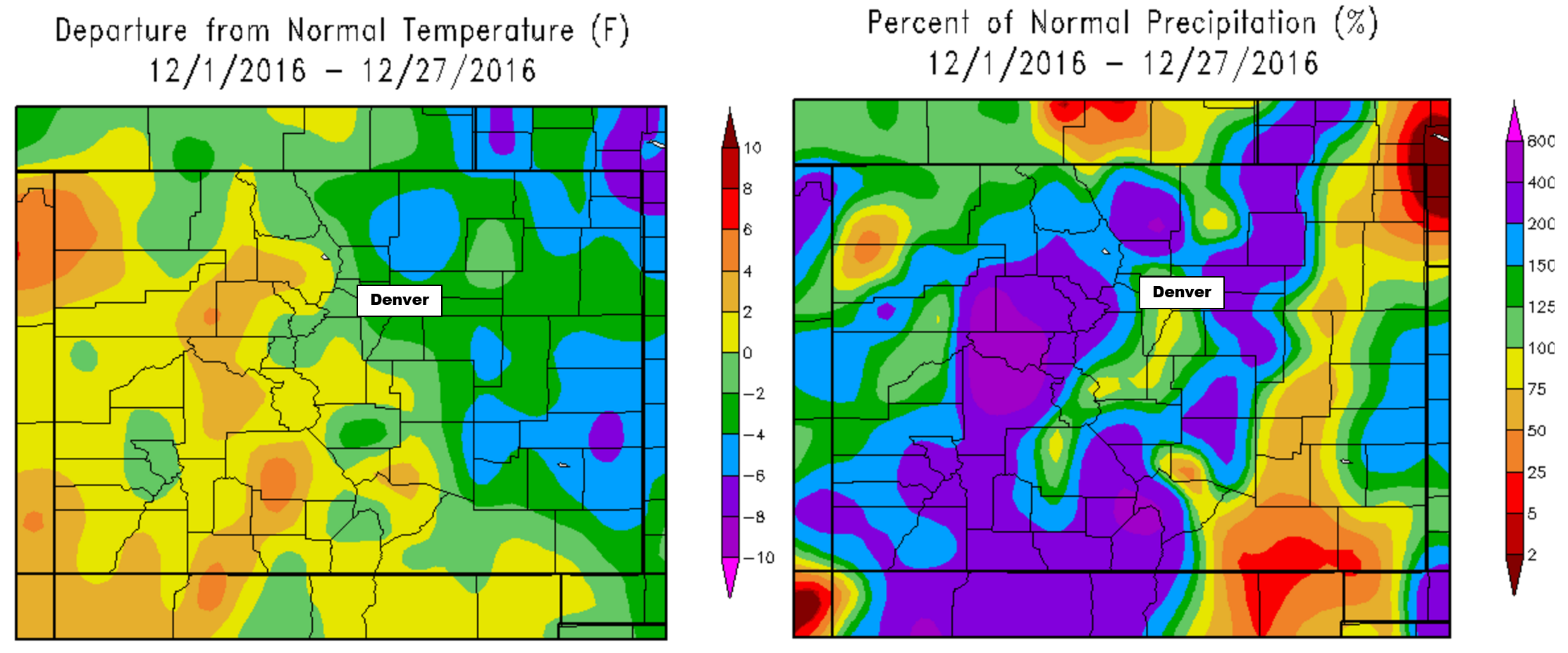
Precipitation and temperature departures from normal for Colorado for the month of December 2016.
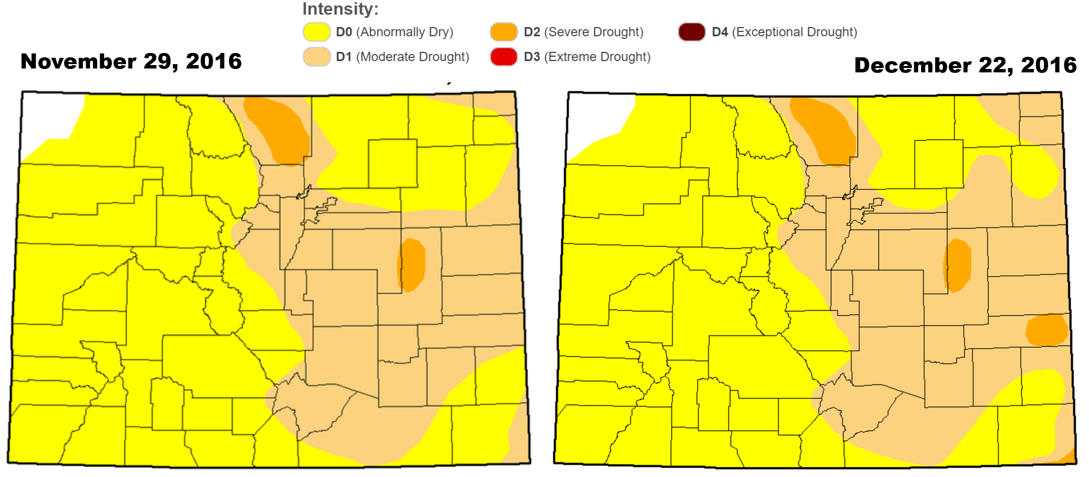
With near normal precipitation, the drought situation hasn’t worsened, but it also hasn’t improved. Shown below is the evolution of drought analysis from the National Drought Mitigation Center over the course of the last month. Very little change is observed, except minor tweaks in southeast Colorado.
If you recall, our December 2016 outlook called for below average temperatures (correct) and above normal precipitation (mostly right) for the Denver Metro area. Here’s how some various inputs into our forecast panned out:
- ENSO: We expected a weak La Niña linger in the Equatorial Pacific during the month of December, which it did as the Oceanic Niño Index remained beneath the -0.5 degree Celsius threshold. We also mentioned that 8 out of 10 weak La Niña Decembers brought above median snowfall and cold weather to Boulder. 2016 fit right into this pattern.
- Weather Model Ensembles: The ensembles handled the first half of December quite well. An active weather pattern and cooler conditions were expected. The ensembles also suggested warmer and drier weather beginning to take hold by the middle of the month, which we did see, to some degree beginning on December 19th through the New Year.
- CFS Climate Model: The CFS had the Front Range on the very fringe of above normal precipitation and below normal temperatures. We’ll consider this verified.
- BoulderCAST Analog Forecast: Our own hand-crafted analog forecast pointed to above normal temperatures for the Front Range (boo!). They also suggested slightly above normal precipitation, which as you know, was correct. Furthermore, they picked up on the drier conditions in southeast Colorado where drought intensification has occurred in the last month.
- NOAA’s CPC: NOAA had the Front Range in elevated chances of above normal precipitation (correct) and temperature (also correct).
Shifting focus to the next month…normally January across the Front Range is beautifully sunny and fairly dry. Let’s take a closer look.
The Norm
The climatological average precipitation in Boulder for the month of January is 0.70″, making the month our driest of the year. Since the year 2000, only three January’s have exceeded one inch of liquid.
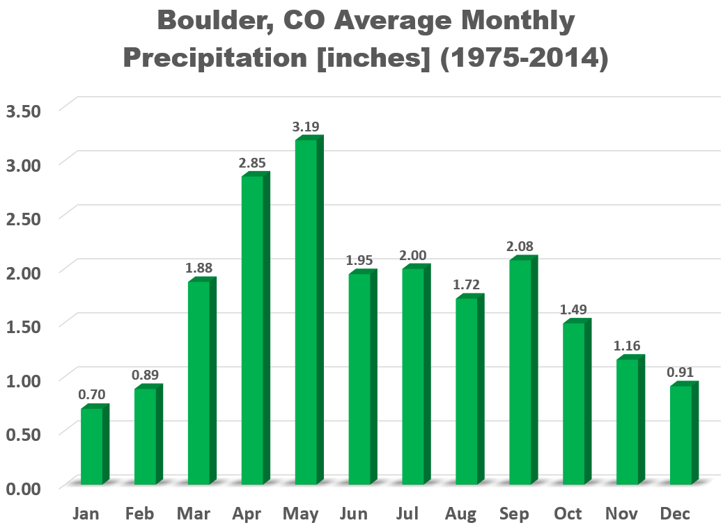
However, due to very cold air and the subsequent fluffy snow ratios, January’s average snowfall is still 10″ in Boulder.
The map below shows the dates when the mean temperature is the lowest of the year. Unlike the eastern two-thirds of the country, the coldest time of year is already behind us in the Front Range.
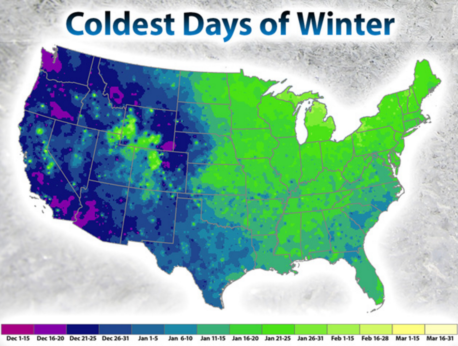
However, in Boulder, the coldest day of the year is actually January 1st, with an average high of 41 degrees and an average low of 18 degrees. Don’t expect a quick warm-up as January progresses, though. Our average high remains mostly stagnant between 42 and 46 through the end of February.
The warmest recorded temperature during the month of January was 77 degrees, observed on January 9, 1934. The coldest was on the 7th of January in 2006, the temperature dropped to an icy -22 degrees.
This Year’s January Outlook:
Below we review several factors individually that we take into consideration for our outlook for January.
LA NIÑA:
We’ll keep this section short and sweet. Yes a weak La Niña is currently active in the Equatorial Pacific Ocean. Through the month, climate models suggest little change in this status, though some do have a return to neutral conditions. Either way, there is no significant relationship between Front Range temperatures or snowfall in January and the projected ENSO conditions. Therefore, we’ll ignore this altogether in our outlook.
WEATHER MODELS:
Model ensembles are in mildly good agreement that the first half of the month will see persistent troughing across the northern Rockies and western USA. With this, we’d expect to see fairly active conditions and cooler-than-normal weather.
GEFS 500 mb ensemble height anomaly through mid-January, so troughing across the western USA
CLIMATE MODELS:
We often consult the Climate Forecast System long-range model to help guide any potential forecast for the upcoming month or season. As you can see below, the CFS model is thinking cool and wet for the Front Range! The magnitudes of the anomalies being forecast by the CFS are quite high (purples and dark red!), which isn’t typical. This is one reason that the signals indicated are more believable to us for the month ahead.
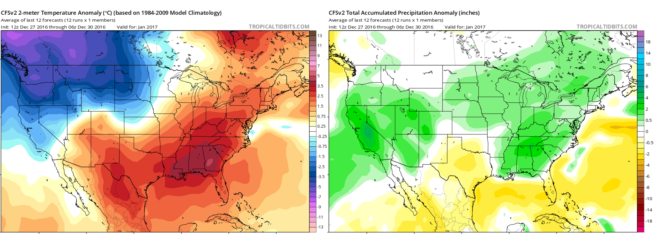
Climate Forecast System outlook for January’s temperature (left) and precipitation (right) anomalies.
BOULDERCAST ANALOGS:
Based on what has occurred towards the tail-end of 2016, BoulderCAST’s algorithms choose the top ten historical analogs (years that thus far have been most similar to 2016 in regards to temperature and precipitation for the Front Range). They point towards this January being colder than normal across the Front Range, but provide no insight for precipitation.
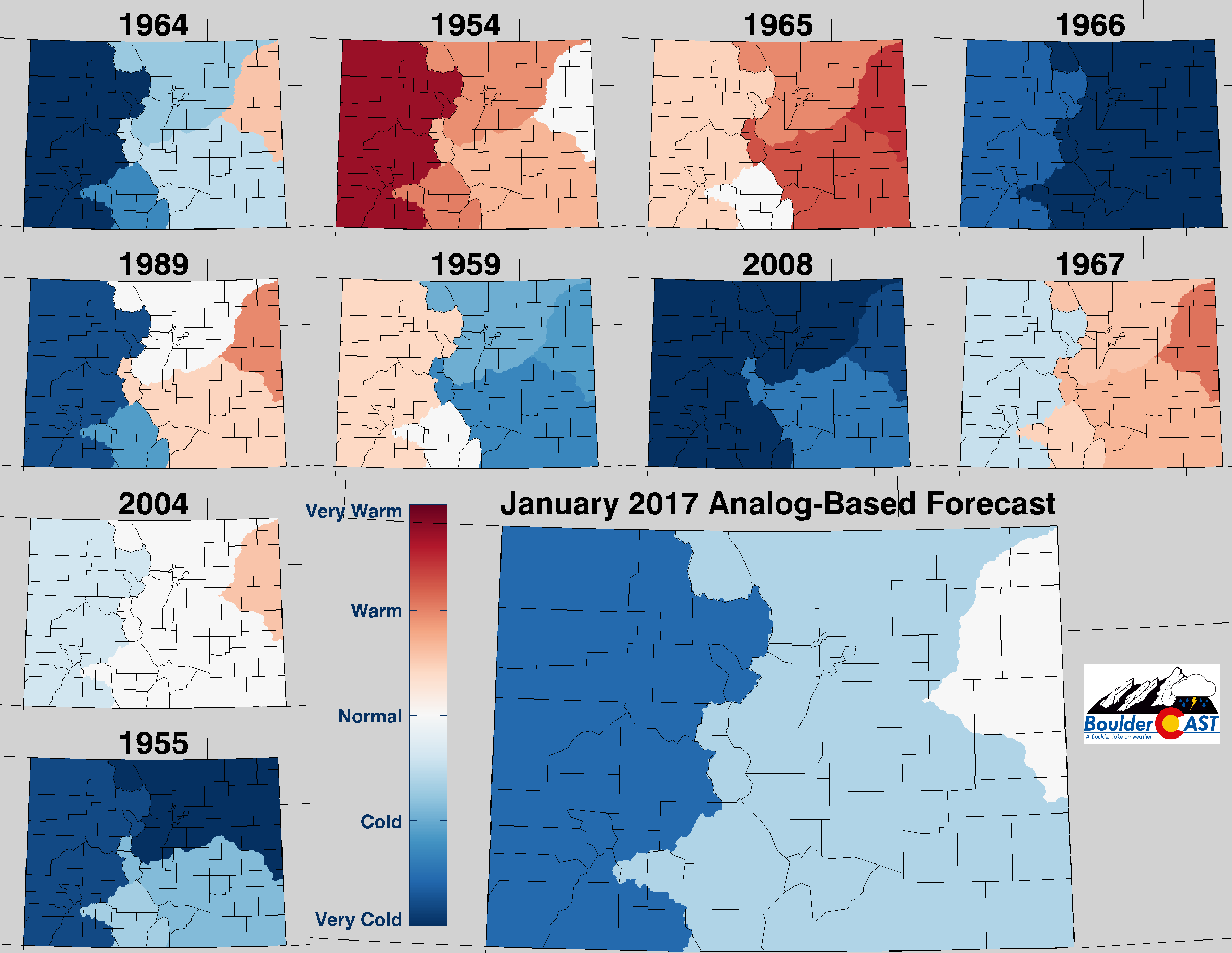
Top 10 Analogs to 2016 and how those years played for TEMPERATURE in Colorado during the month of January. The large map shows the analog-based weighted consensus forecast based on those 10 years.
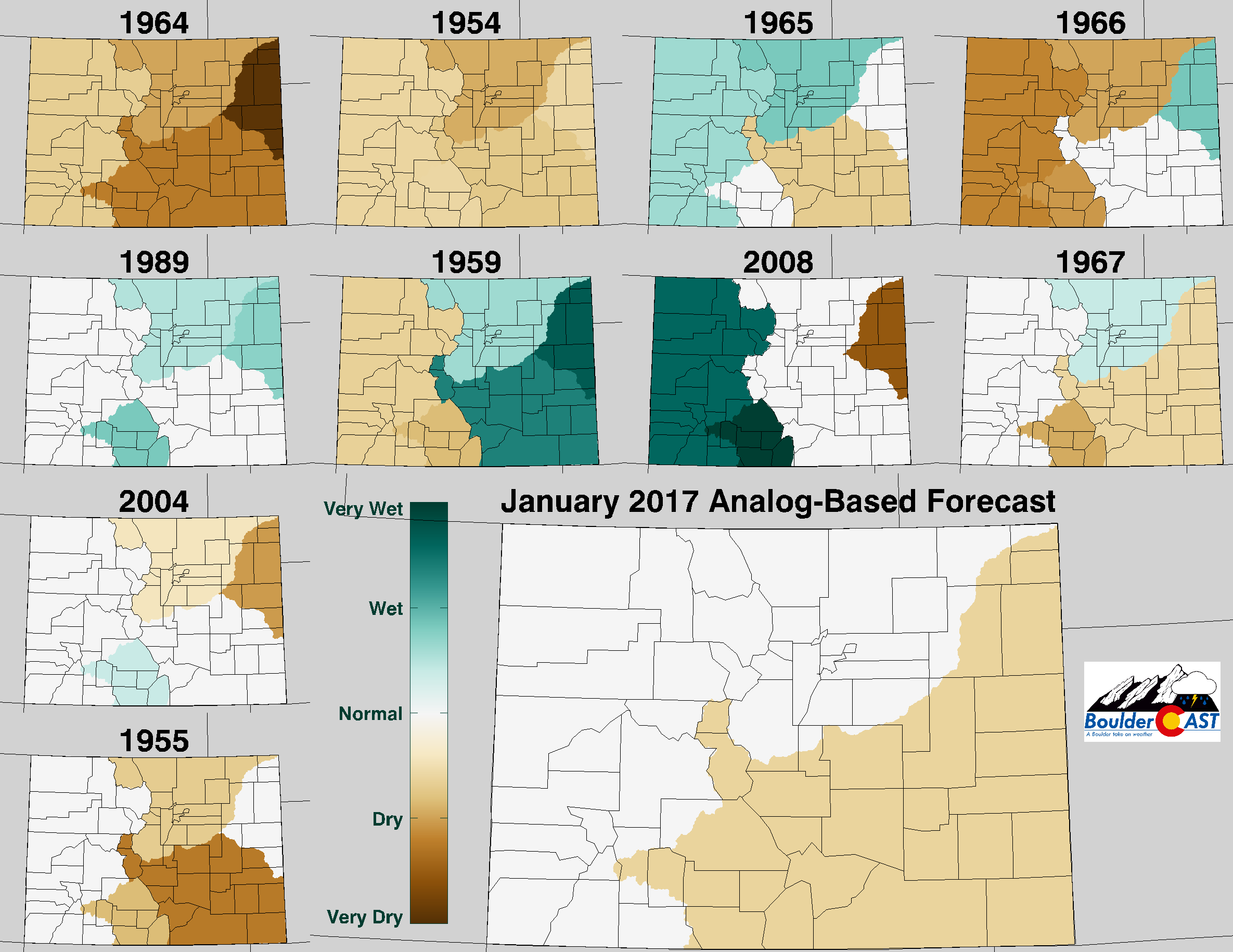
Top 10 Analogs to 2016 and how those years played for PRECIPITATION in Colorado during the month of January. The large map shows the analog-based weighted consensus forecast based on those 10 years.
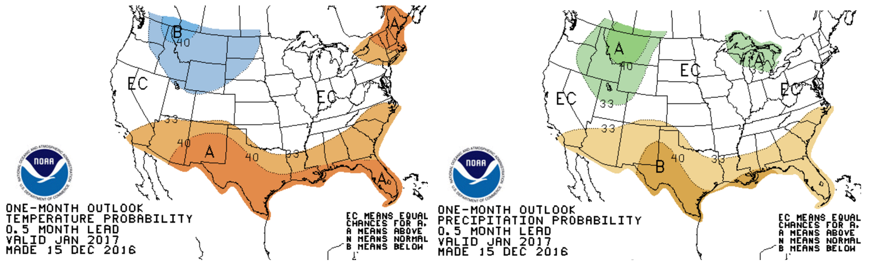
NOAA’S CLIMATE PREDICTION CENTER:
The Climate Prediction Center is keeping the Front Range in “equal chances” of all scenarios (i.e. have no clue what may happen).
IN SUMMARY…
Considering all of the aforementioned factors, BoulderCAST is predicting below normal temperatures for January with above average precipitation for the Front Range.
We tend to believe what the models are showing for the first two weeks of the month. Most are in good agreement of the cooler, troughy pattern. It remains to be seen if we’ll be able to cash in on the cold air with some snowfall as well. January is our driest month, so if we get a little snow this upcoming week, we should be well on the way to near-normal precipitation by month’s end.
As far as the actual forecast, brace for the cold! The first chunk of January will once again feel like winter as Colorado will find itself within the heart of an Arctic air mass beginning Tuesday and lasting through the weekend, with snow likely flying several days as well. Temperatures may remain entirely below freezing for three to five days, possibly longer (this was discussed in our weekly outlook on Monday).


You must be logged in to post a comment.