
Our weekly outlook mentioned that it would be a cold and snowy week. We cautioned that the weather models were not in good agreement on much of anything, and therefore were hesitant to believe them, despite the indication of a couple potentially impactful snow events. Today that has changed, with all the major models jumping on-board for a significant snow storm for the region beginning Wednesday afternoon and continuing through the day Thursday. We provide an initial update on what to expect for the second half of the week during what will likely be our biggest snowfall this winter season.
The key players for this storm are listed below:
- Shallow push of cold, Arctic air arriving Wednesday afternoon: This will provide a period of upslope to the region Wednesday evening into Thursday. There is some indication that this upslope could reach up to the 700 mb level (about 10,000 feet elevation).
- Copious Pacific moisture contained in the northwest flow: While this won’t be a major player for the Plains, this mid-level moisture overrunning the Arctic air will enhance snowfall over the Mountains and Foothills. Could be a good seeder-feeder set-up.
- Left exit region of a jet streak: Northern Colorado will be in a favorable region for heavy jet-forced snow bands, especially Wednesday night and early Thursday. We know how quickly these bands can put down the snow. This bands will produce localized snowfall rates in excess of 1 to 2″ per hour.
- Fairly cold air: This will breed fluffy snow to liquid ratios at or above 15:1
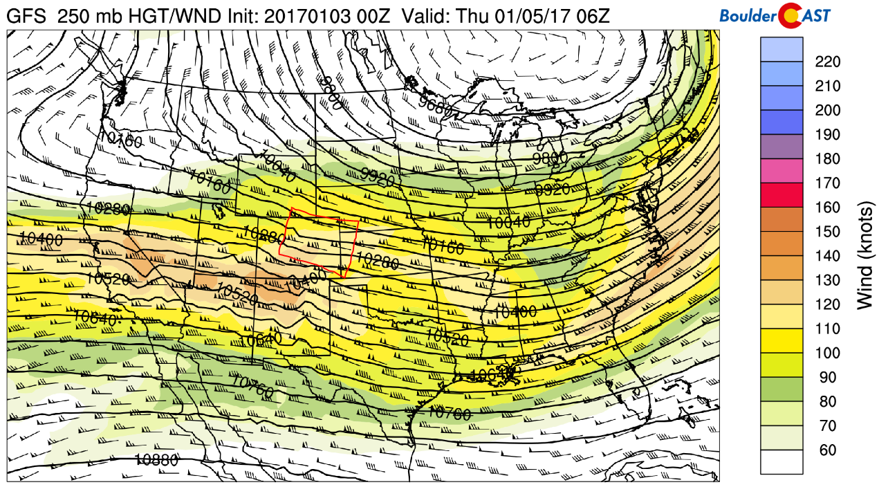
GFS 250 mb wind forecast map showing a jet steak and expected region for snow bands to form Wednesday night (red box).
Timing:
The second push of cold air is set to slam into northeast Colorado Wednesday during the late morning or afternoon hours. Behind this front, we expect snow to spread across the region from north to south late Wednesday afternoon or early evening. Snow will already be flying in the higher elevations by Wednesday morning. With jet-forced bands in play alongside the upslope, moderate, to at times, heavy snow will continue through Wednesday night. There is some disagreement on when the snow may come to an end. The GFS model has it lingering into Thursday evening, while the European model brings snow to an end Thursday morning.
Wednesday’s evening commute could be a little dicey, but even that will seem like a walk in the park compared to what is possible for Thursday morning, especially in areas in and near the Foothills.
Preliminary snowfall forecast amounts:
The models are producing a large amount of liquid for this event…almost too much to believe considering the Arctic air mass that will be in place. The GFS (and its ensemble) and NAM model both spit out ~0.5″ in Denver, ~1.0″ in Boulder, with ~1.5″+ in the Foothills. This amount of liquid, when converted to snow, would bring our largest storm so far this year to the region. However, we caution that this week in general has been filled with fast and furious model shifts. We’re not 100% sold on this storm yet, but things are looking up for BIG snow totals across the region!
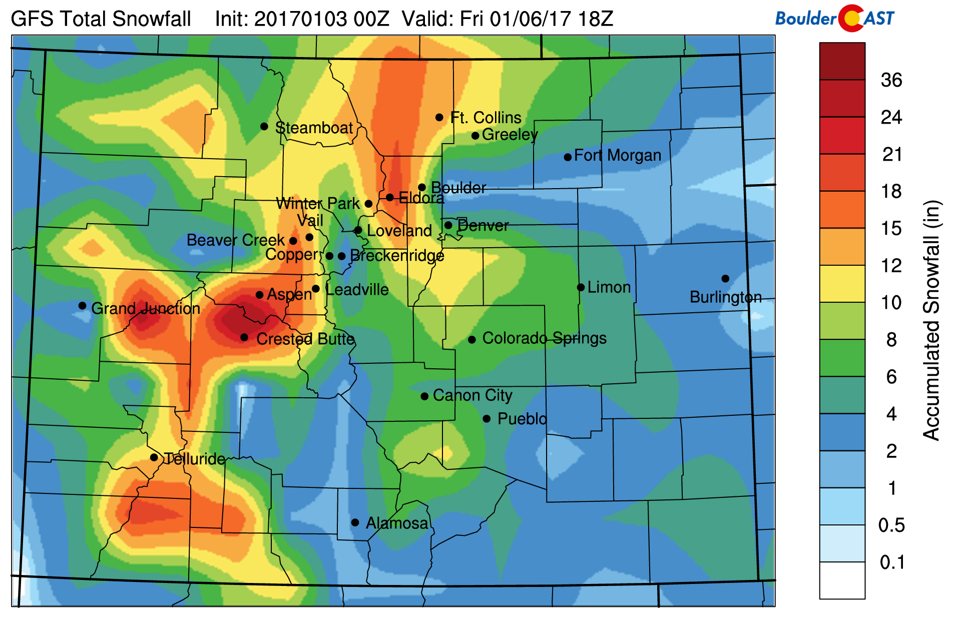
GFS snowfall forecast through Friday afternoon
Here is what we are thinking now…
- Western Metro area, including Boulder, Golden, Broomfield: 7-15″
- Rest of Denver Metro area: 4-9″
- Foothills below 10,500 feet: 10-20+”
- Mountains above 10,500 feet: 15-30+”
This is the type of storm where there could be large differences in snow amounts from location to location, and one where Boulder should crush Denver in final storm totals. We’ll post our final forecast snow map tomorrow morning with more focused ranges. We’re hopeful that the models will stick to their guns, but this storm has a higher than average “bust” potential. But for now, get ready for some snow and cold temperatures!
If you plan to head out skiing any of the next several days, you’re definitely in for a treat (see below)! Yes, that is 3 feet of snow being forecast for Eldora this week! Webcams and detailed ski forecasts for each resort can be found on our PowderCAST page.
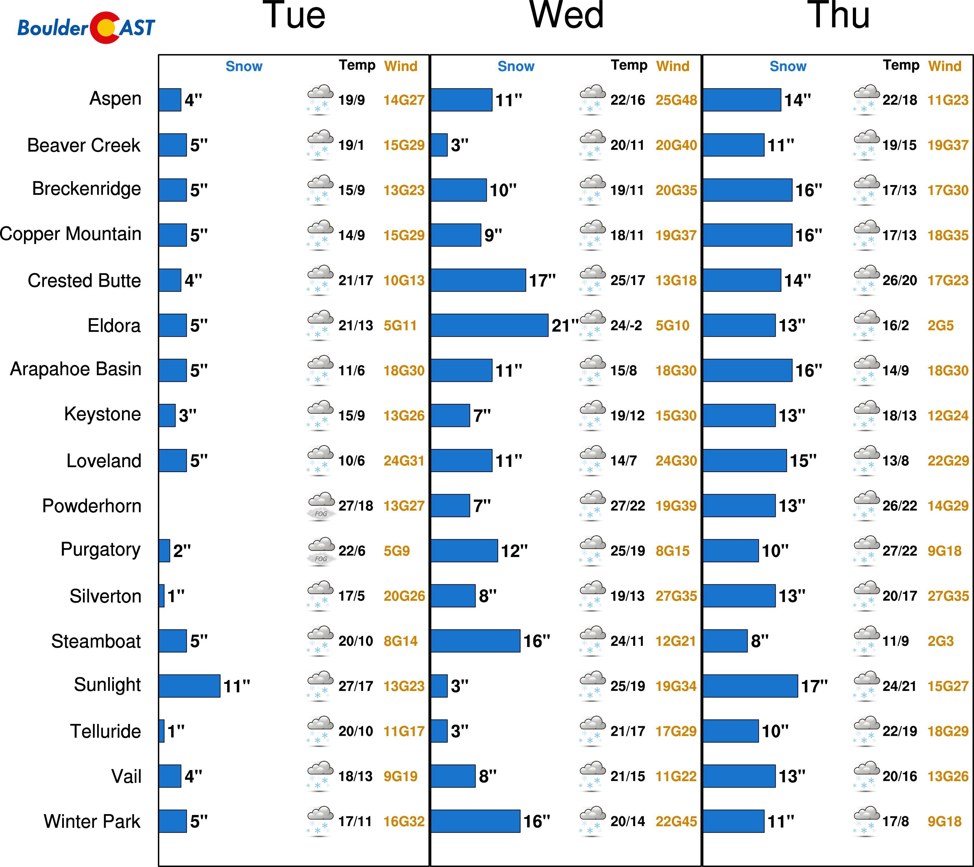
Ski forecast for the next few days…LOTS of powder out there!


You must be logged in to post a comment.