
Our weather during the month of April was very fickle. Eleven consecutive warm days kicked off the month but were quickly followed by a prolonged period of cold and snow on the heels of several Arctic outbreaks. The important result, however, was a significant improvement in the drought across northeast Colorado. Here’s a quick and colorful rundown of our weather during April 2021 and how it relates to climatology.
Help support our team of Front Range weather bloggers by joining BoulderCAST Premium. We talk Boulder and Denver weather every single day. Sign up now to get access to our daily forecast discussions each morning, complete six-day skiing and hiking forecasts powered by machine learning, first-class access to all our Colorado-centric high-resolution weather graphics, bonus storm updates and much more! Or not, we just appreciate your readership!

Top Weather Highlights of April 2021:
WARM BEGINNINGS: We began the month with eleven consecutive days of above average temperatures. This included two new daily record highs in Boulder on April 3rd (78°F) and April 4th (80°F). Many Front Range cities were on pace for their warmest April on record. Of course, that was only the first third of the month and brutal cold set in shortly after, dashing everyone’s hopes for a warmer than normal month.
With a persistent ridge pattern developing, record highs will be on the chopping block across the Front Range this weekend! 🔥
We'll be near or above record values Saturday through Monday (and maybe Tuesday) before cooler air works in next week#COwx #RecordHighs #Boulder pic.twitter.com/gh9H0IKFCG
— BoulderCAST Weather (@BoulderCAST) April 1, 2021
ARCTIC OUTBREAKS: The middle of the month was characterized by prolonged cold and snow as several storm systems with Arctic origins descended on the Front Range. Between April 13th and April 22nd, there was only one completely snowless day in Boulder!
A look at the conditions in the #Boulder area this morning. Just wet in town, but some snow-covered roadways above 8000 feet.
More regional webcams: https://t.co/L0VLejKuY3#COwx #Boulderwx #Snow pic.twitter.com/jlSwAutgbe
— BoulderCAST Weather (@BoulderCAST) April 13, 2021
The most intense Arctic front moved in on April 19th paving the way for several days of record cold, including the latest ever 10°F reading in Boulder on April 20th.
Possibly the last Arctic cold front of the season steamrolling southward across eastern Colorado this morning! There might also be a rare "roll cloud" at the leading edge of the Arctic front across far eastern Colorado. #COwx pic.twitter.com/R7SfeORjxe
— BoulderCAST Weather (@BoulderCAST) April 19, 2021
Snowy Flatirons and Longs Peak #boulder #flatirons #longspeak #mountains #frontrange #mountainrange #colorado #wx #weather #snow #cold #aerial #photooftheday #pic pic.twitter.com/j2Lq08tL1T
— Jason Mowry (@jmowry11) April 20, 2021
This final push of Arctic air produced the largest snowstorm of the month for the Denver Metro area on April 19th into the 20th. Snowfall totals ranged from 3″ in Denver, to 7″ in Longmont, to 9″ in Boulder, to 15″ in Allenspark!
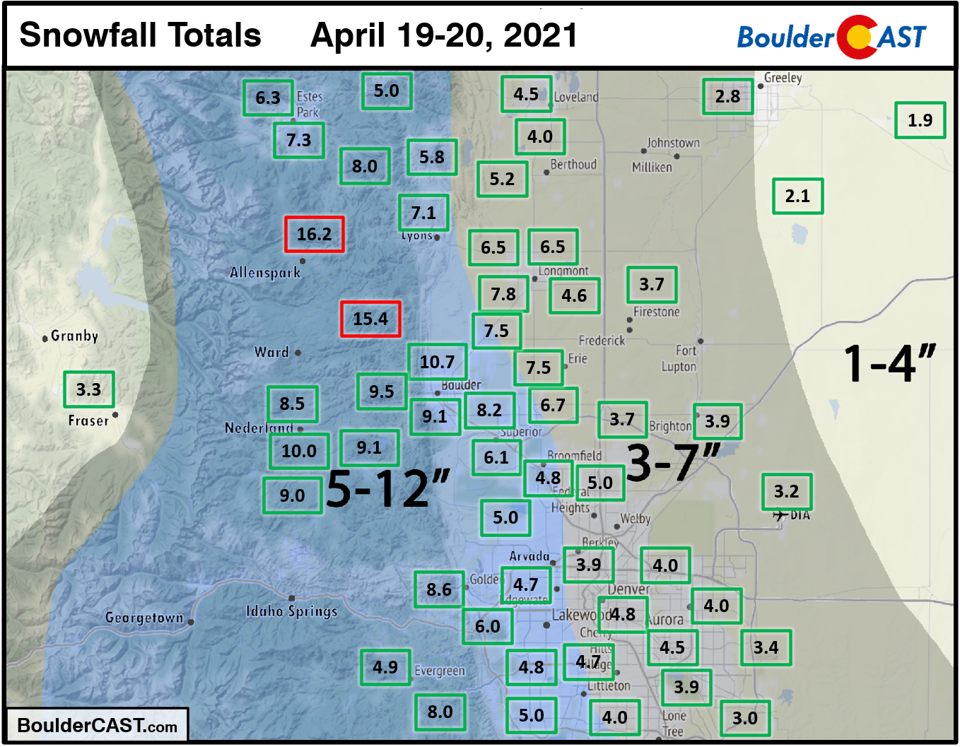
April 2021’s biggest snowstorm!
This lengthy cold snap bumped up seasonal snowfall totals considerably. By the end of April, Boulder eclipsed 100 inches of snow for the second year in a row, while Denver notched its snowiest season since 1984!
Updated 2020-21 seasonal snowfall totals! This has now been Denver's snowiest winter since 1984 & the most snow ever recorded at @DENAirport (which became the climate site in the 1995).
The 103" in Boulder is the most in a season since…last year, which had a record 152" #COwx pic.twitter.com/yGwbpIkUyQ
— BoulderCAST Weather (@BoulderCAST) April 23, 2021
ONE INCH RAINSTORM TO END THE MONTH: April’s weather finale was a round of showers and thunderstorms that eventually transitioned to widespread upslope rain/snow on the 27th and 28th. Boulder reported just over 1″ of rain from this event (no snow), while upwards of 10″ of snow fell in the Foothills. This same storm contributed to the rockfall that closed Boulder Canyon.
Boulder Canyon is closed due to a large rockslide on Colorado 119. https://t.co/GRHGRvYo9b
(📸:: Darris Harris Frisby) pic.twitter.com/Tn145LCVDC— Denver7 News (@DenverChannel) April 28, 2021
Despite the crazy month, the final precipitation total in Boulder was only 3.20″ which is just slightly above normal, now the third consecutive month with above normal precipitation for most of the Front Range. The latest update from the US Drought Monitor has revoked the drought status for Boulder and Denver. Statewide drought coverage dropped from 92% to 80% during the month. This is excellent news as we head into our wettest month of the year (May!). However, as you can see in the graphic below, all of this improvement came from the northeast quadrant of the state. Southern and western Colorado are still very much in trouble.

April 2021 Recap Graphics:


Spread the word, share Colorado weather:
We discuss Boulder and Denver weather every single day on BoulderCAST Premium. Sign up today to get access to our daily forecast discussions every morning, complete six-day skiing and hiking forecasts powered by machine learning, access to all our Front Range specific weather models, additional storm updates and much more!
Featured image of the snow Front Range by Jason Mowry.


You must be logged in to post a comment.