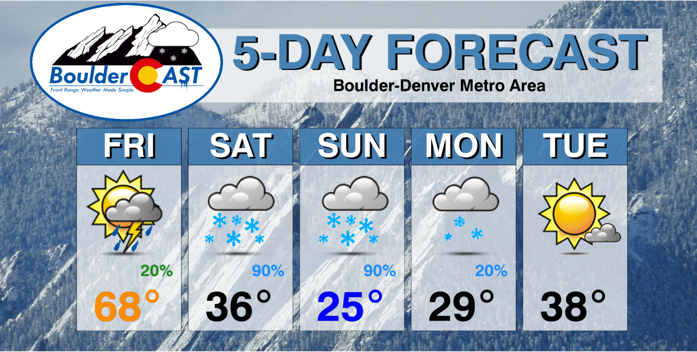
It may have seemed like spring was here to stay the way this week has played out so far — but alas, winter is gearing up again just in time for the weekend. We’ve got two different storm systems to discuss with you this evening. The first will offer a slight chance of thunderstorms Friday evening followed by a threat of heavy convective snow early Saturday morning. The second system will bring sub-freezing temperatures and lighter upslope snow to the entire area on Sunday. Let’s take a look.
At a Glance:
- One last spring-like day on Friday with temperatures in the 60’s before winter returns this weekend!
- Spotty thundershowers possible Friday evening into the overnight
- A change-over to snow will occur very early Saturday morning with a burst of heavy wet snow looking increasingly likely — though uncertainty is still elevated
- Depending on change-over timing and snowfall rates, several inches of slushy accumulation could occur across the lower elevations
- A longer-lasting and colder upslope snow event takes hold Saturday night into early Monday with additional accumulations essentially guaranteed
We discuss Boulder and Denver weather every single day on BoulderCAST Premium. Sign up today to get access to our daily forecast discussions every morning, complete six-day skiing and hiking forecasts powered by machine learning, access to all our Front Range specific weather models, additional storm updates and much more!

T
his week has certainly been a nice change of pace across the Denver Metro area with now four consecutive days at or above 60 degrees — and Friday sure to be the fifth!
🍊 you glad you're on the west side of the stalled frontal boundary today? We've got lower 70's in Denver this afternoon, but it's the middle 30's in the northeast corner of Colorado! #COWx pic.twitter.com/0neYdkjuUy
— BoulderCAST Weather (@BoulderCAST) March 3, 2022
If you read our weekly outlook, you know where this forecast discussion is going. We hate being the bearer of bad news (or do we?), but the large-scale pattern is already in transition across the western United States. “First spring” is winding down and “third winter” is about to commence! Two storm systems are coming ashore from the Pacific Ocean very soon which will ultimately make for a much colder and snowier weekend ahead here in the Front Range! At least we got to enjoy a small sampler this week of the upcoming spring season…
Can you spot the two incoming storms in this evening’s GOES-East water vapor satellite animation below?

GOES-East water vapor animation from Thursday evening
If not, that’s okay — we have you covered. The first storm we are watching is currently spinning just off the coast of California. This will be a player for us Friday evening into midday Saturday as it tracks almost directly over Denver from west to east. The second storm is currently situated off the coast of British Columbia of Canada. This one we are tracking for an excellent chance of upslope snow on Sunday for us.
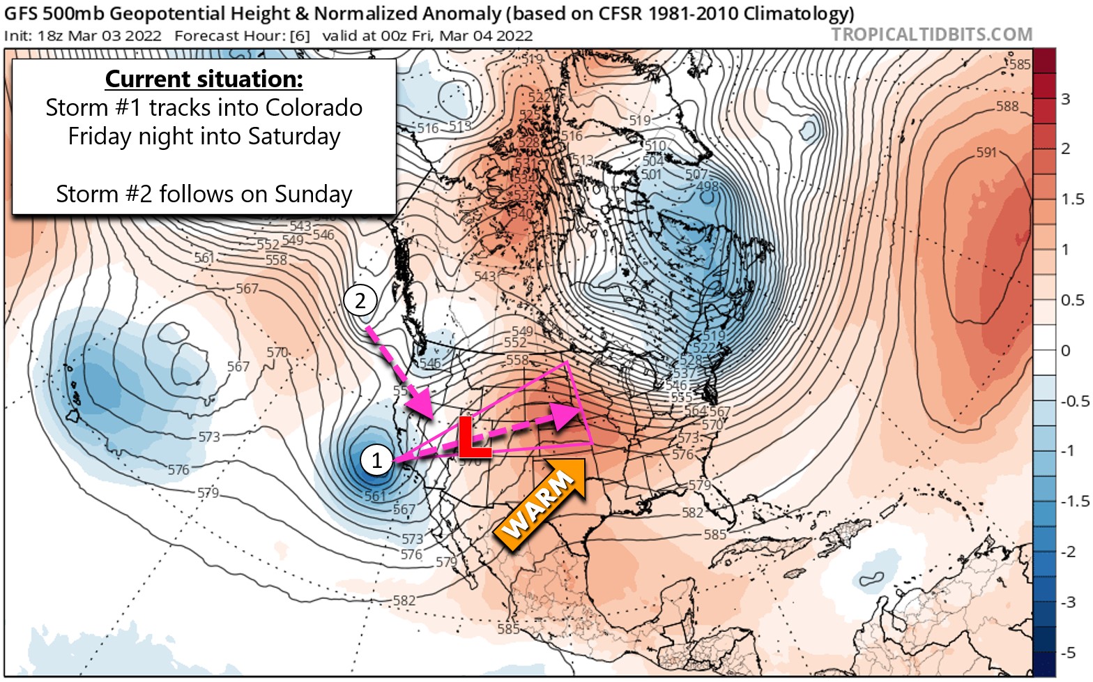
Let’s briefly talk about both of these wintry systems.
Storm #1: Friday evening into Saturday morning
The first storm headed our way via California is certainty the more “spring-like” of the two. It’s coming hot on the heels of the warmest weather we’ve seen in many months. Yes, it’s got plenty of moisture, but it’s also entering into a very warm environment with not much cold air of its own, at least initially. The system will progress across the Four Corners on Friday bringing a smattering of late-day rain/snow showers in the Mountains and spotty thundershowers (yes you read that right!) to the Denver area in the evening and overnight hours.
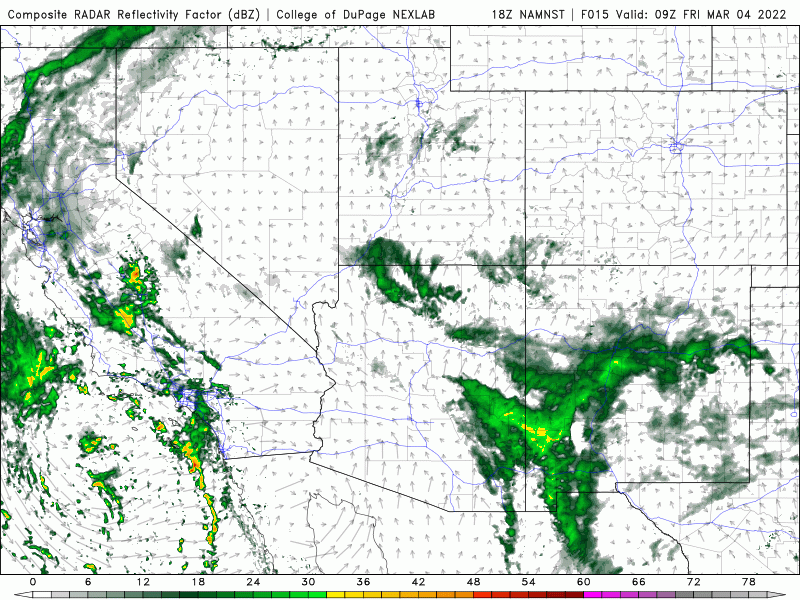
NAM-NEST simulated radar animation Friday into early Saturday as Storm #1 moves through
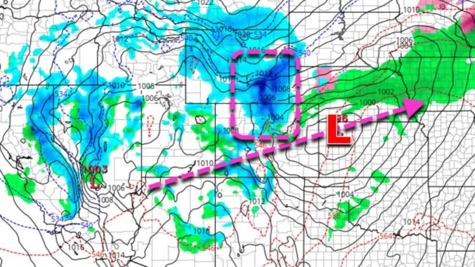
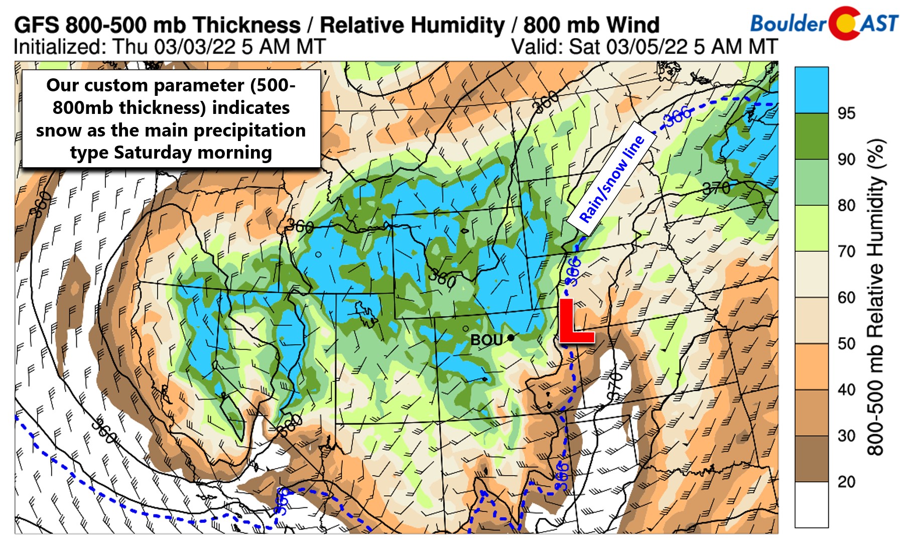
As the system kicks east off the Mountains, a surface low will develop east of Denver early Saturday morning. Northwest of this low across northern portions of the Front Range, convective instability and frontogenesis will combine to produce an environment very ripe for heavy rain and snow development. This area is highlighted in the GFS forecast map below for Saturday morning.
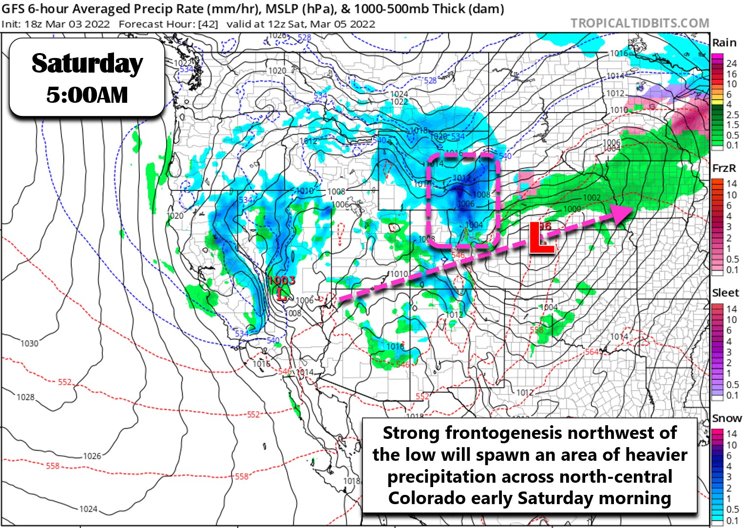
With spring in the air, the challenge this weekend will be the warmer temperatures, potentially spoiling the wintry party for the lower elevations during Storm #1. While for certain it will begin as all rain Friday evening, temperatures will be dropping into the 30’s overnight across the area. Models have been trending colder the last couple days, which is a good sign for snow-lovers, but we’re still not exactly sure who will see snow and who will see more of that pesky rain. Our in-house snow level forecasts for early Saturday based on two models (below) show snow levels sitting in the ballpark of 5000 to 6500 feet elevation around the Boulder-Denver area. This means we’ll be right on the cusp of rain and snow. Ughh! Given how intense this band of precipitation could be, we’re leaning towards a snowier situation for the lowlands as evaporative and dynamic cooling of the atmosphere can go a long way this time of year to bring our temperatures down. Even colder conditions are likely further north and northeast in the state.

Over the last handful of years, we’ve been developing in-house methods to help us pin-down the precipitation type in these very situations during the transitional seasons. The typical methods used across the nation really aren’t valid at this high of an altitude. One such parameter we have come to liken is 800-to-500mb thickness. This is basically the depth of the lower half of the atmosphere. Since colder air is denser, it will have lower thicknesses. Warmer air will have higher thicknesses. Through some trial and error, we’ve identified the 3,660 meter depth as where the rain/snow line typically sets up in eastern Colorado (shown below as the blue dashed line). This parameter is telling us that Saturday morning will be quite snowy in the Denver Metro area, or at least temperatures will be cold enough for it should the snow gods favor us. This is still a model forecast and thus it still comes with the same levels of uncertainty.
While the lower elevations will start as rain and stay there for a chunk of Friday night, it will be mostly all snow in the higher Foothills with a focus on Boulder and Larimer Counties Friday into Saturday. These areas could see 3 to 8″ of snow from Storm #1. In and around Boulder proper, probably a dusting to 4″ is a passable forecast for now. If temperatures stay too warm, we could see next to nothing stick. If it gets colder faster (as we are thinking they will), a couple slushy inches could pile up fast. Denver is on the fringe of things with this first system and can expect lower totals Saturday morning (perhaps a trace to 2″?).

At this point, we have to mention the latest high-resolution HRRR model forecast which has just come off the supercomputers this Thursday evening. Its initial crack at the storm is doubling-down on our expectation of the colder solution for the Front Range. This model develops a convective band of precipitation right over the Front Range in the wee morning hours Saturday. It begins just briefly as rain but changes to heavy wet snow fast — and that lasts for several hours.
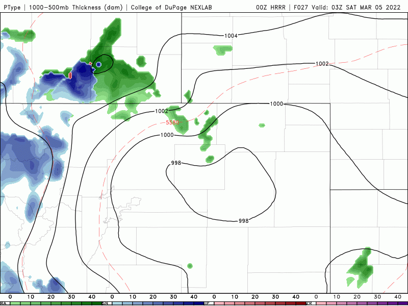
While currently an outlier, this usually-reliable model is generating 5 to 10″ of slushy snow from Denver to Boulder Saturday morning! This model’s prediction is plausible and further puts a focus on the Saturday morning window for potentially more substantial winter impacts. Stay tuned!

HRRR model snowfall forecast for Saturday morning. This model has 5-10″ in Boulder & Denver
As the first low pressure pushes east through Kansas and Nebraska, things will quiet down across the Front Range with drier conditions expected Saturday late morning through the early evening. This calm window will proceed Storm #2 — one that will offer a better chance of snow for our entire area.
Storm #2: Sunday (and beyond!)
The storm arriving late Saturday into Sunday will be the truly wintery one with origins from a more northern latitude. The atmospheric temperature forecast at 10,000 feet elevation below shows the colder punch packed by the secondary system relative to the first.
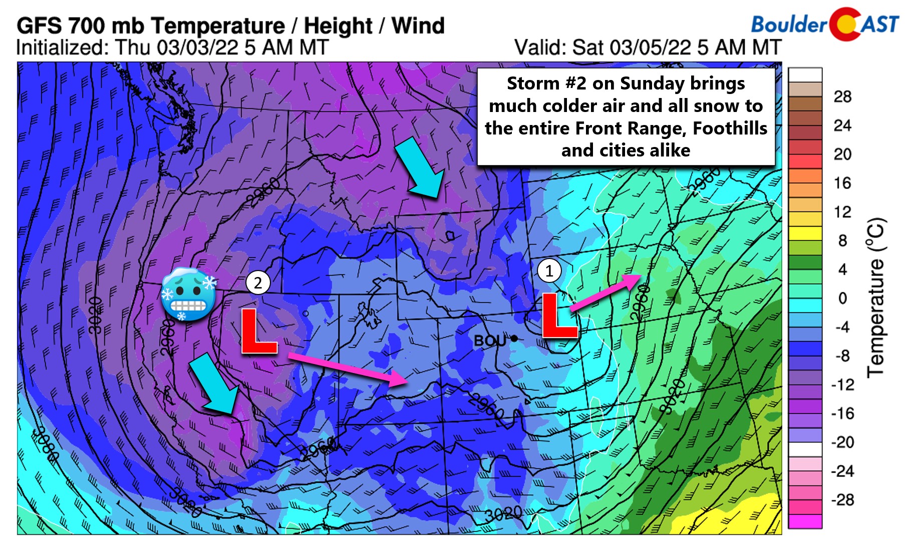
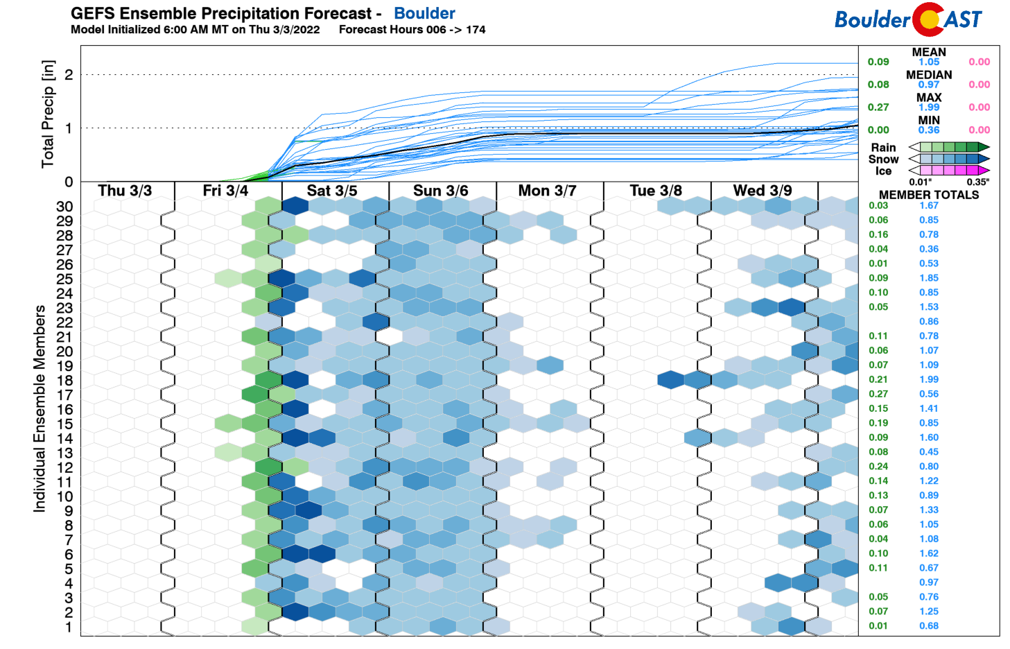
The second storm won’t be as dynamic, and instead will be relying on just weak large-scale lift and shallow upslope to produce snow in the Front Range. It’s a long duration event, though, with temperatures staying below freezing Saturday afternoon, Sunday and probably Monday as well. Light but persistent snow could add up late in the weekend into Monday, especially in upslope-favored areas like Boulder which could see something like another 3 to 6″ from Storm #2. This is still 60 to 84 hours away though, so we’re not too keen on making any predictions for Saturday night into Monday morning just yet!
For now plan on an “interesting” Friday night with rain eventually changing to heavy wet snow, with potential travel impacts early Saturday. Then some quiet time before light snow ramps ups for much of Sunday into Monday. Enjoy the last bit of warmth on Friday while you can! More to follow…
Get BoulderCAST updates delivered to your inbox:
Help support our team of Front Range weather bloggers by joining BoulderCAST Premium. We talk Boulder and Denver weather every single day. Sign up now to get access to our daily forecast discussions each morning, complete six-day skiing and hiking forecasts powered by machine learning, first-class access to all our Colorado-centric high-resolution weather graphics, bonus storm updates and much more! Or not, we just appreciate your readership!
Enjoy our content? Give it a share!


You must be logged in to post a comment.