
Category: Winter Weather (Page 63 of 139)
These posts contain some discussion of the white stuff, whether it be mountain snow pack or a Front Range snowstorm.

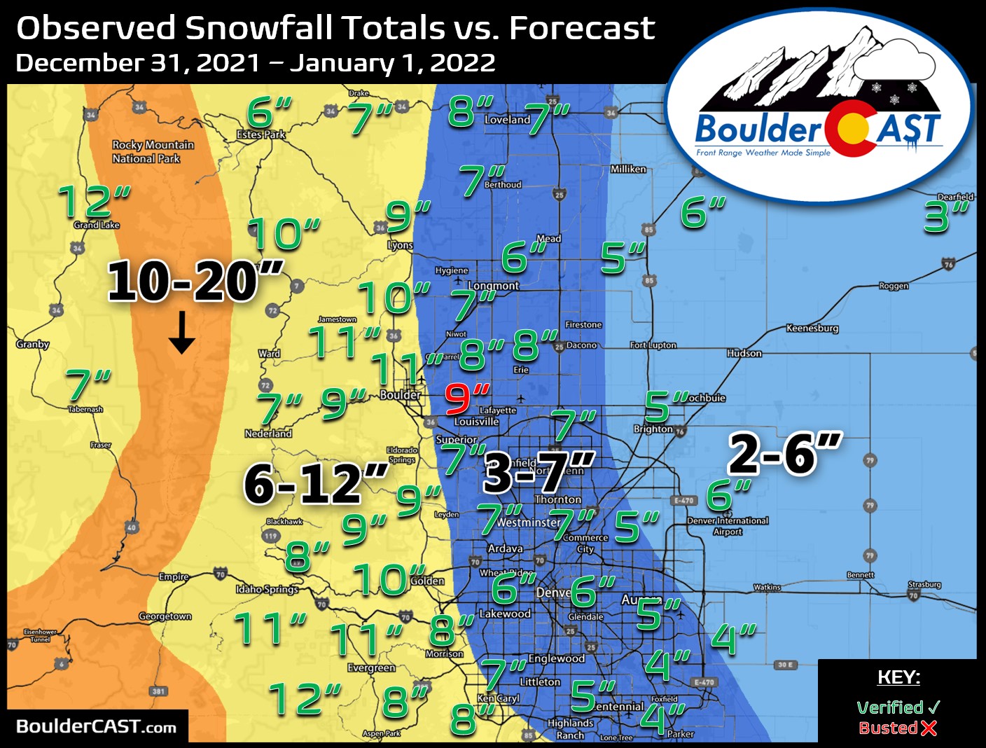
Hooray! The New Year’s Eve snow event is confirmed and whether you like it or not is coming in on the higher-end of initial predictions as models continue to slow the storm down and usher in the bitter cold air to the Front Range. How much snow are we expecting? Will New Year’s Eve travel be significantly impacted? And how cold will it get? We have a lot to discuss so let’s get right into it!
Premium Storm Update (12/31/21 6:00AM): We do final check on the latest model runs and take a look at some of the more in-depth aspects of the event including a forecast time series of the upslope profile. READ HERE.

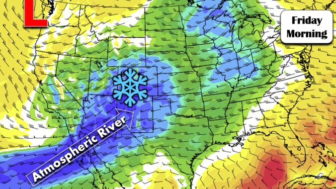
Our state has benefited greatly from the recent atmospheric river event with snowpack thankfully getting back close to normal for now. However, things remain dreadfully dry east of the Continental Divide. The week ahead will offer generally cooler than normal temperatures across the Denver area with continued Mountain snowfall really piling up. We are also tracking a potential Arctic outbreak and some snow just in time to ring in the New Year. Here’s the latest.
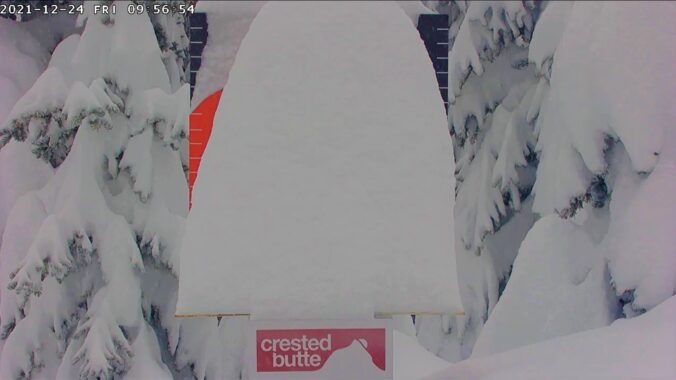
We provide a quick update on the ongoing atmospheric river event which will pile up feet of snow in Colorado’s mountains by Christmas morning. With mild temperatures holding across the lower elevations and a few rare December raindrops falling from the sky, it looks like a white Christmas will elude us once again.
We review the climatology of White Christmas conditions in Boulder, including a discussion on why Christmas Day has the second highest occurrence of snow on ground out of the entire year. We also discuss the upcoming pattern shift which will favor widespread snowfall in the Mountains and maybe a little white stuff in Boulder, too.
Temperatures will remain well above average throughout the week as the Front Range remains under favorable downslope warming. Gusty winds may be possible at times given this setup but overall a pleasant week lies ahead. Heavy mountain snow is expected by the end of the week with a strong and moisture-rich storm system. Read on to find out if there are any snow chances in the works for the lower elevations as well.
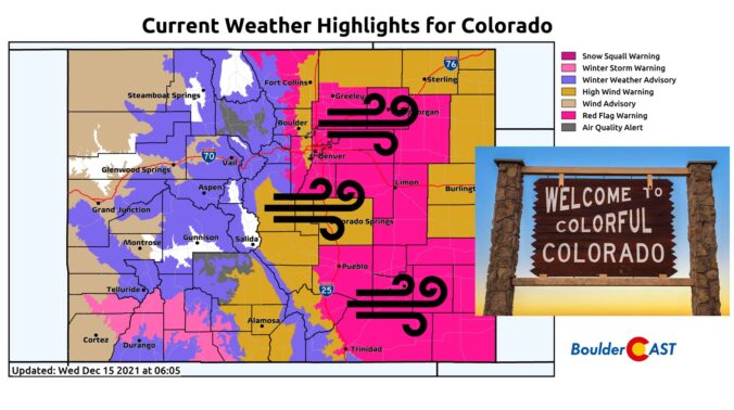
Things are about to start rocking and rolling across the Front Range as a potent storm system rapidly races across Colorado early this morning. Here’s the latest update on the timing of everything, where the snow squall is headed, potential snow amounts, and the all-important wind speed outlook.
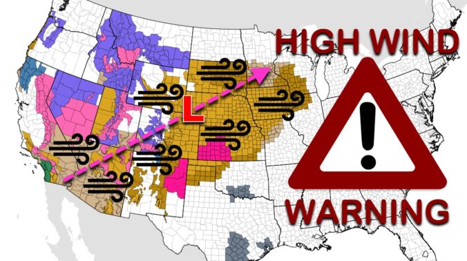
Batten down the hatches! A significant and potentially historic wind event is about to unfold across the Front Range on Wednesday with gusts reaching up to 100 MPH. A band of heavy snow will also race across the state during the morning hours creating dangerous travel, especially in the Mountains. Let’s review the setup, the timing of the snow and strongest winds, and the potential snow amounts and impacts across the area.

Live View of Boulder

Current Conditions

Live Radar

Recent Premium Posts

BoulderCAST Daily – Wed 06/03/26 | Scattered P.M. storms again as moisture peaks for the week
🌬️ Weak westerly flow aloft today with no major synoptic features nearby; only …
BoulderCAST Daily – Tue 06/02/26 | Storms Reload This Afternoon, But With Noticeably Less Bite
❄️ Monday delivered lots of hail to northeast Colorado, with one supercell tracking …
BoulderCAST Daily – Sun 05/31/26 | Dry and warm today but rain chances increase this week
🌦️ Overall dry and warm Sunday, though cannot rule out a very widely …
3-Day Forecast

Trending Content

© 2026 Front Range Weather, LLC
You must be logged in to post a comment.