
Hooray! The New Year’s Eve snow event is confirmed and whether you like it or not is coming in on the higher-end of initial predictions as models continue to slow the storm down and usher in the bitter cold air to the Front Range. How much snow are we expecting? Will New Year’s Eve travel be significantly impacted? And how cold will it get? We have a lot to discuss so let’s get right into it!
Premium Storm Update (12/31/21 6:00AM): We do final check on the latest model runs and take a look at some of the more in-depth aspects of the event including a forecast time series of the upslope profile. READ HERE.
At a Glance:
- The first significant snowstorm is headed for Colorado Friday into Saturday accompanied by the coldest air of the season so far
- Before the cold and snow, a high wind event will impact the Boulder area Thursday bringing hurricane-force gusts and high fire danger
- Two cold fronts will impact the area on Friday dropping temperatures into the teens by midnight Friday night
- Jet-forced bands of heavy snow possible during the day Friday, but the main event of light/moderate upslope snow comes in Friday evening into Saturday
- 6-12″ of snow expected in Boulder and the Foothills, with 3-7″ around Denver
- Bitter cold temperatures follow the snow with highs in the lower teens Saturday succeeded by near or below zero readings Saturday night
We discuss Boulder and Denver weather every single day on BoulderCAST Premium. Sign up today to get access to our daily forecast discussions every morning, complete six-day skiing and hiking forecasts powered by machine learning, access to all our Front Range specific weather models, additional storm updates and much more!

T
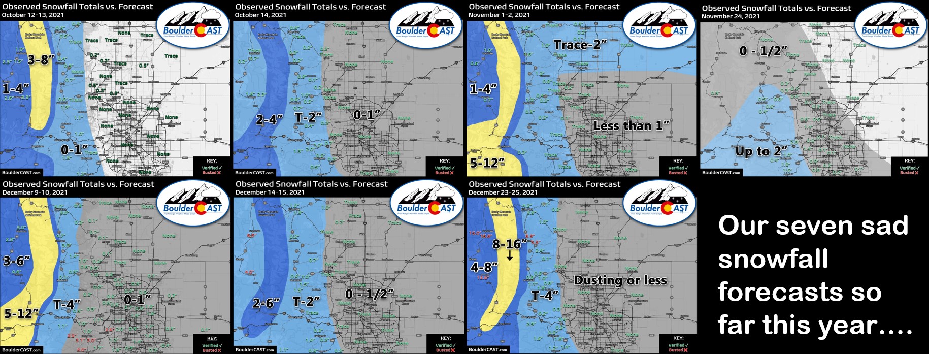
his is the moment many of us have been waiting for over the last few months. Yes, today we get to discuss with you our first real snowstorm of the season! So far, our team has issued seven official snowfall forecast maps. However, none of them included the potential for Boulder or Denver to see more than 1″ of snow. In many cases, it was even less. We’ve really had to grasp at straws to find anything interesting to talk about weather-wise over the last few months. We’re excited to say that with the impending storm that finally changes!
We have been tracking this storm for nearly a week now, first alerting you to the elevated likelihood of a interesting snow event back on Monday in our weekly outlook. At that time, this storm looked promising, but expectations were tempered as the models have let us down so many times already this year when trying to peek too far ahead. This incoming storm system arises from the combination of a very cold trough from the northwest and a small piece of energy moving our way from the Baja.
Through the week, the storm has evolved into something stronger, slower and thus more substantial for winter weather impacts. Models are now coming into fairly good agreement. We are thus quite confident how this event will play out. Let’s get into the details.
High winds & high fire danger Thursday
The focus for this particular forecast update is the cold and snow on the way for New Year’s. However, winds will be very gusty during the day Thursday as a downslope wind event rocks the western Metro area. The jet stream is draped across Colorado in a manner that will bring strong winds down to ground-level east of the Continental Divide. Gusts of 60 to 90MPH are expected from Boulder to Fort Collins and in the Foothills.
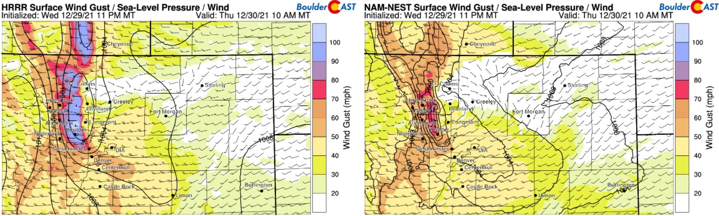
However, we’ve already seen some gusts over 100+ MPH in parts of Boulder and Jefferson Counties this morning. Trees and power lines are going down.
Three separate sites along Hwy 93 in close proximity to one another reported gusts of 100+ MPH in the last hour. Be careful out there folks! Trees and power lines are coming down!! #COWx #HighWinds #Boulder #Golden pic.twitter.com/F73EnoNUW8
— BoulderCAST Weather (@BoulderCAST) December 30, 2021
Several grass fires ignited both north and south of Boulder. Be careful out there folks!
Last video. I’m moving!!! pic.twitter.com/GsesauMpGf
— Eric English (@EricEnglish777) December 30, 2021
More details on the extremely windy weather can be found in our Premium weekend outlook posted earlier this morning. Winds will die down after sunset Thursday.
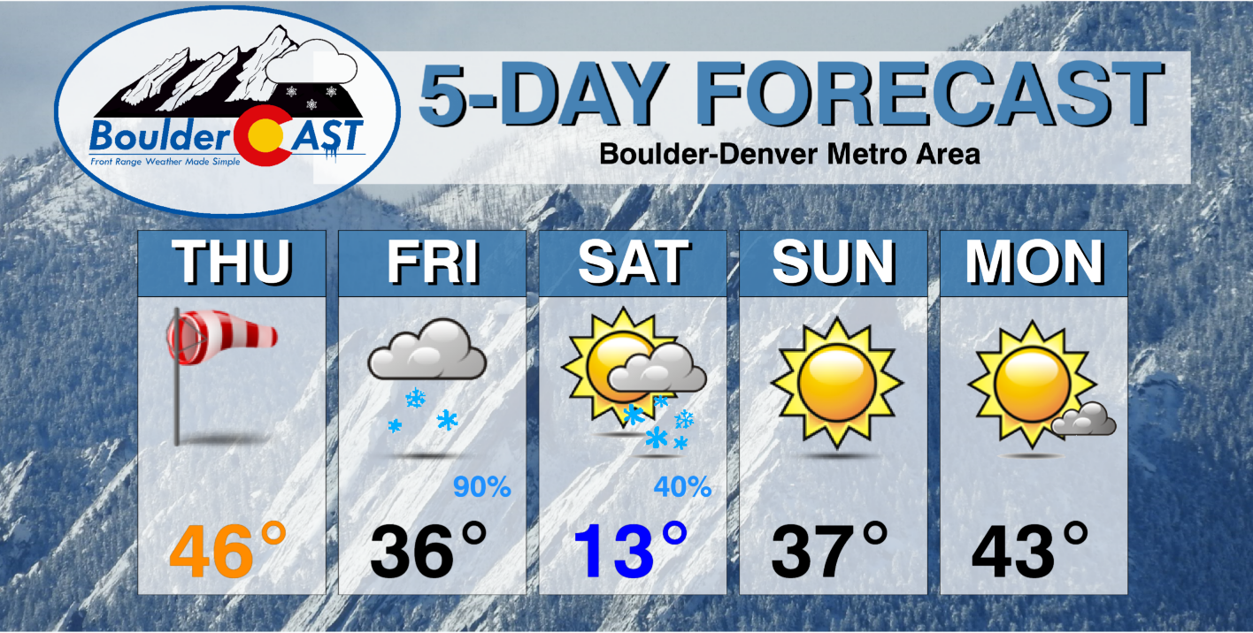
Significant snow and bitter cold Friday into Saturday
We’ve been mostly spared from unseasonably cold weather so far this season. In fact, the National Weather Service noted that this is the longest Denver has ever made it without having a day with a below freezing high temperature. It’s been close a couple of times, but on all occasions the “midnight high” was above freezing. We’ve also already reiterated just how atypically warm this autumn has been in prior posts.
2021 broke the record for the latest day in the winter in Denver not to have a high temperature <32 degrees (in 150 yrs). However, the high on New Year's Day will remain well below freezing, just for one day though. Top 10 lowest high temperatures table & forecast graph: #cowx pic.twitter.com/Kxm1Jnboyv
— NWS Boulder (@NWSBoulder) December 30, 2021
Our luck runs out abruptly on Friday with the arrival of a much colder airmass with Arctic origins. It will move through the Front Range in two waves — the first coming during the morning hours on Friday, and a second even colder push arriving during the early evening hours. It’s the second front that will get things fully saturated and kick-off the upslope snow machine we’ve all been waiting for!
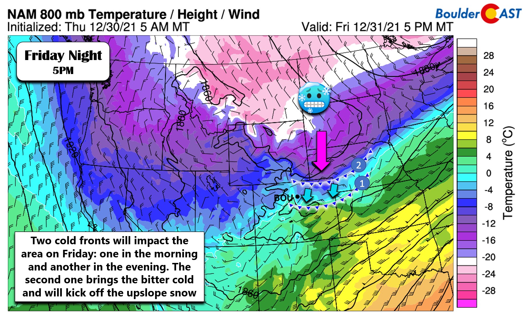
With the arrival of the first cold front so early in the day Friday, our high temperature will be in the morning hours and land somewhere in the 30’s. Temperatures will remain steady in the 30’s or fall slightly into the 20’s during the day before dropping quickly in the evening after the second front. During the day the low-levels will remain somewhat drier over the Denver Metro area, but there will be some jet forcing around capable of producing pockets of banded snowfall across northeast Colorado. Pretty much anywhere from Fort Collins to Denver could catch one of these bands which could easily put down 1 to 3″ of quick snow. Outside of these snow bands, daytime accumulation will be minimal. Do be aware of spotty travel impacts during the day Friday and know it will be much worse in the Mountains.

Later during the evening, the secondary bitter cold push will move in from the northeast across the Denver area. This will initiate what will end up being 12+ hours of upslope snowfall for the region. During the evening and the overnight, favorable upslope from the east-northeast direction will ensue. It’s not the strongest upslope we’ve seen of course, but this direction is very efficient for the Boulder-Denver area and will lead to steady light to moderate snowfall region-wide through the evening into Saturday morning.
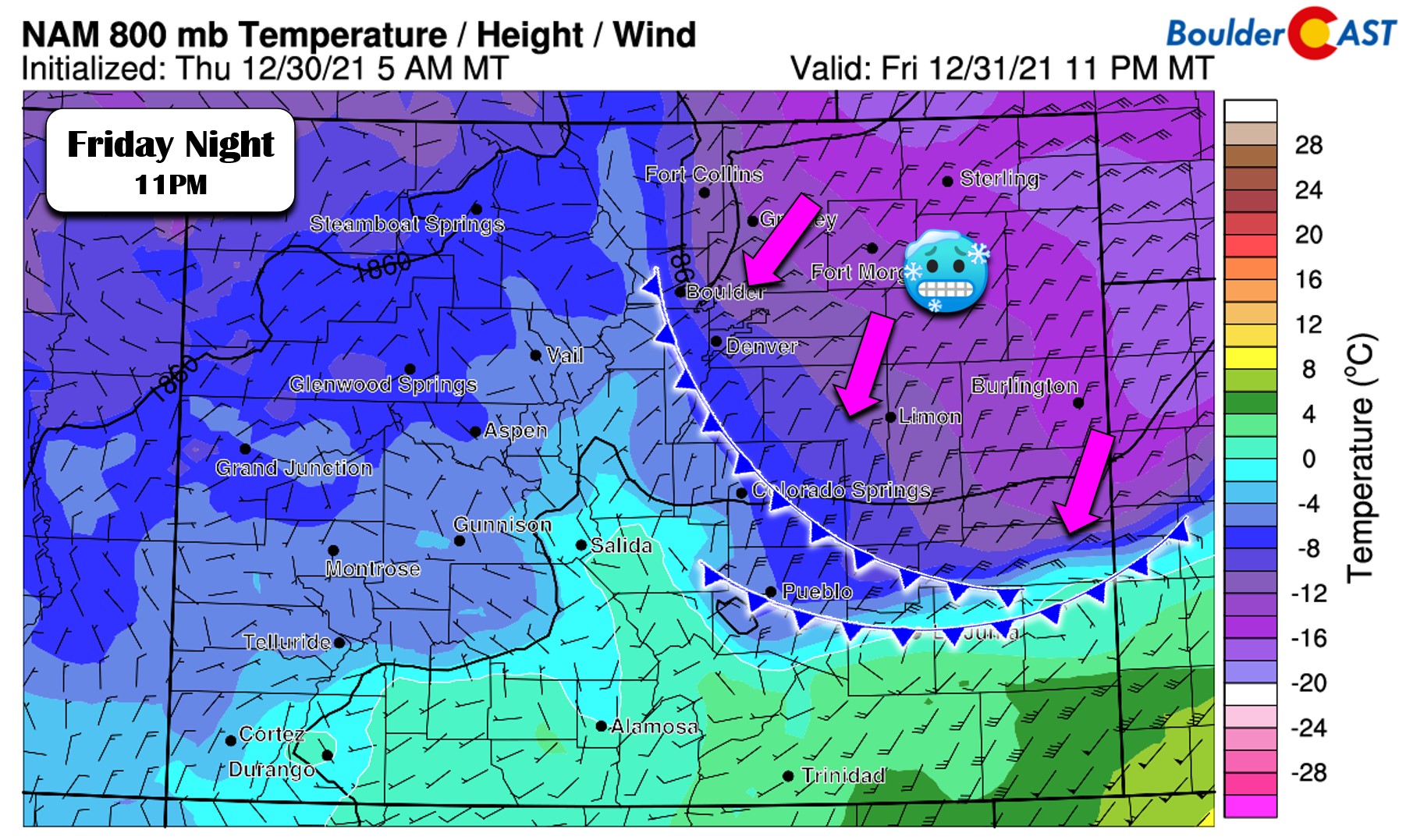
One concern we do have with this storm is the lack of deep upslope. What we have shown so far have been low-level winds and temperatures near the surface. If you go up in the atmosphere to near 10,000 feet elevation (as shown below) we see that winds during the overnight are mainly northerly or westerly — neither of which are upslope for our area.
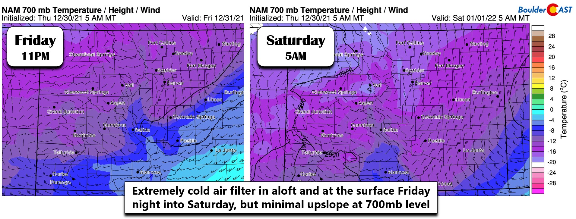
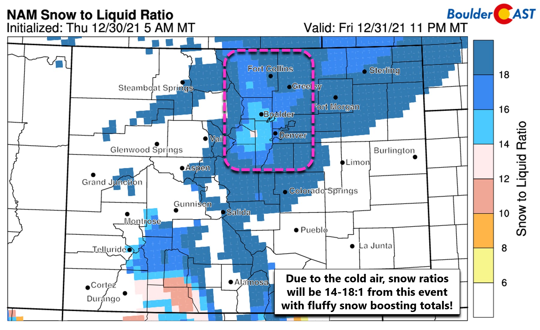
Something else to consider from the above panels are the very cold temperatures aloft. This bitter cold will raise snow to liquid ratios and overall help to boost snowfall totals with this event. This very cold air is one reason we are quite confident in the higher-end snow totals with this storm. Essentially colder air produces fluffier snow which piles up deeper than soupy snow for the same amount of moisture. Our in-house snow-to-liquid ratio algorithms show this event having ratios of 14:1 to 18:1 across the area. Very early Saturday it actually gets so cold that we start to see snow ratios come back down which happens when it gets too cold, especially in the Foothills where it will be well below zero. Due to the lack of deeper upslope and the almost “too cold” of temperatures, we think the highest snowfall totals may elude the higher Foothills and instead target the areas along the base of the Foothills up to 7500 feet.
So how much snow are we expecting with this storm? Models have come into fairly good agreement on how much moisture will dump on the Front Range with those amounts trending upwards largely owing to the storm slowing down and thus extending the duration of the snow. We really like the look of the GFS precipitation forecast below. Areas west of I-25 will do best from this storm thanks to the main driver being somewhat shallow upslope.
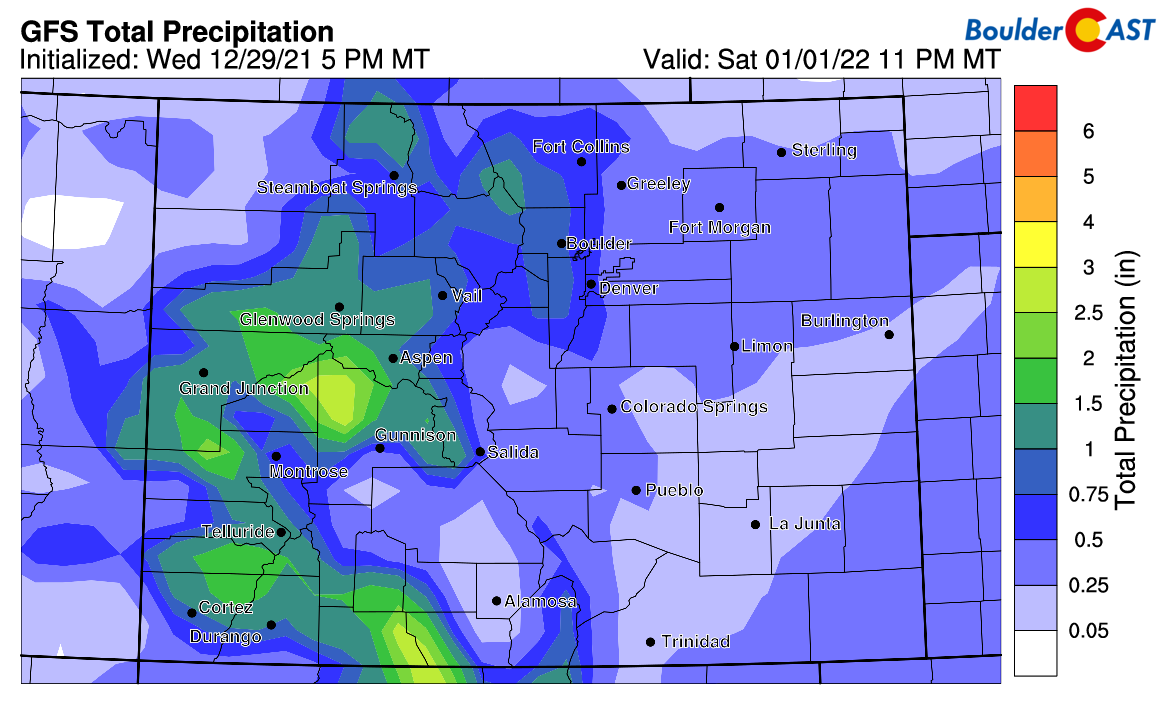
We’re seeing great ensemble agreement for this storm as well. Approximately 0.5 to 0.7″ of liquid is in the works for Boulder. At a 15-to-1 snow ratio, this produces anywhere from 7 to 11″ of snow.
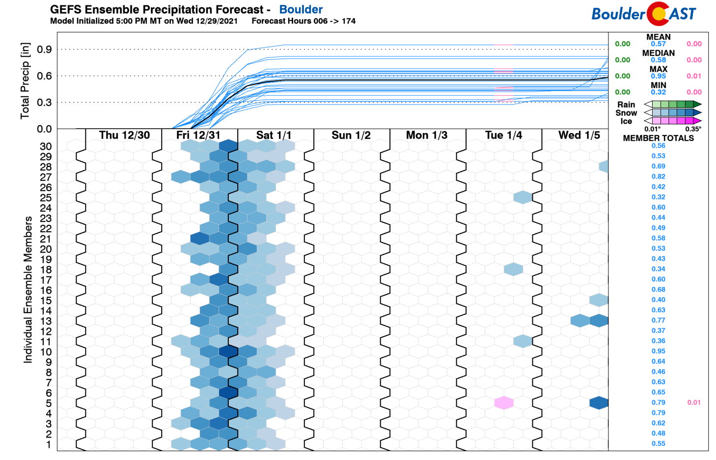
For Denver, models agree well on about 0.2 to 0.5″ of liquid. Using the same 15:1 snow ratio, this will result in totals of 3 to 8″.

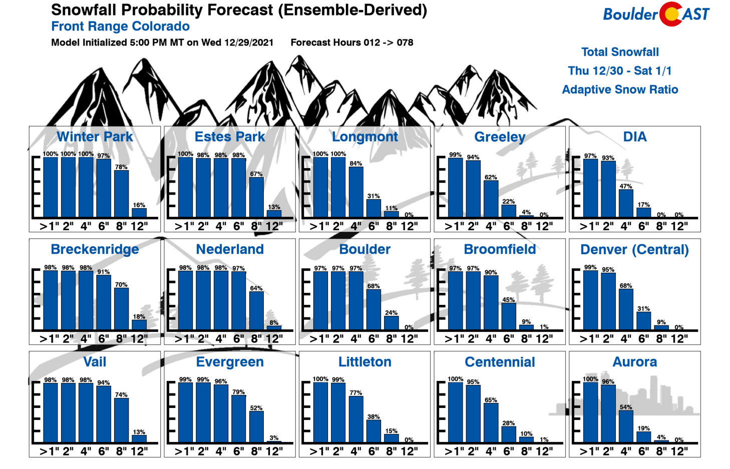
Our updated snowfall probabilities show the potential for various snow amounts falling in cities across the Front Range and nearby Mountains. Where does your locale land?
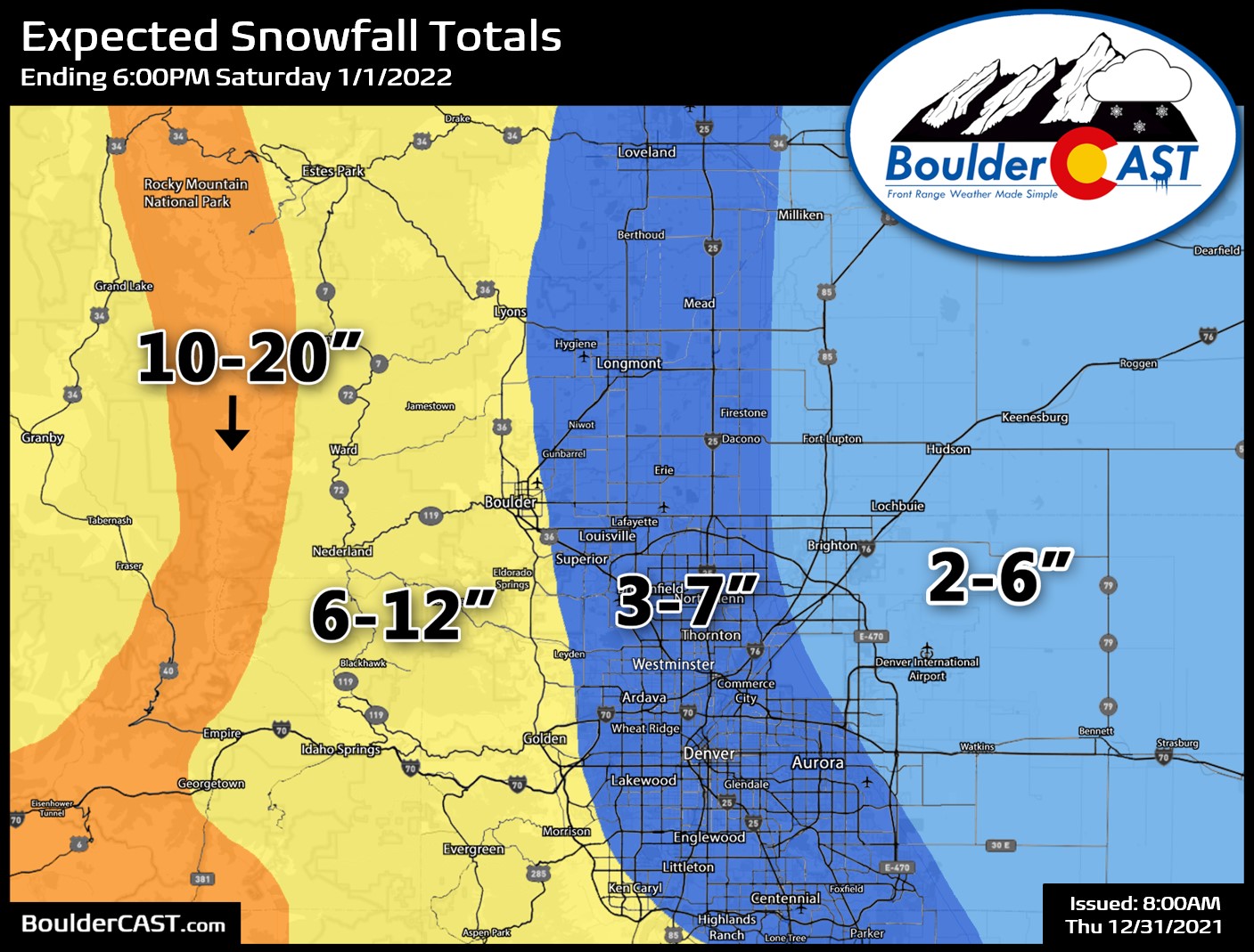
The ingredients coming together with this event are locked-in. We fully expect a blanket of fluffy snow to really stack up with this one — certainly the most snow we’ve seen since the April timeframe. Boulder, in particular should easily see 6″ from this event. On the higher end, a foot isn’t entirely out of the question! Our snowfall forecast map is shown below. This covers the spotty jet-forced snow bands Friday afternoon and then the main event which is the widespread light to moderate upslope snow Friday evening into late Saturday morning.
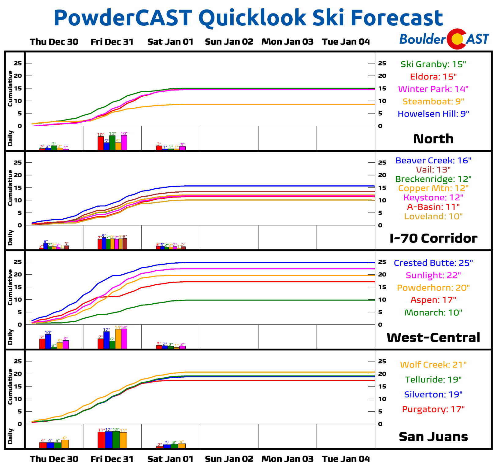
The Mountains will continue to get dumped on Thursday into Saturday with another 1 to 2.5 feet of snow likely for most high mountain ranges and ski resorts. The heaviest snow will come during the day Friday and it should be plenty powdery this time (unlike the soup that fell from the prior atmospheric river event). Our PowderCAST forecast shows you really can’t go wrong these next few days — a great time can be had skiing at any resort statewide! Just be careful traveling to and from the slopes as falling snow will be worsened further by strong winds.
Finally, a quick note on the frigid temperatures that will accompany the snow. The coldest weather of the season lies ahead arriving just in time for New Year’s Eve festivities. Expect temperatures in the 20’s much of Thursday evening, likely falling into the teens before the clock strikes midnight to bring us into 2022. Here’s what some models are currently predicting for downtown Denver’s temperature at midnight Friday night:
- GFS: 22°F
- NAM: 18°F
- Euro: 18°F
- HRRR: 18°F
- NAM-NEST: 18°F
- Canadian: 16°F
Note that outlying areas will likely be a bit colder than this, and also that models tend to underestimate how drastically temperatures can drop behind Arctic fronts. Consider these forecasts to be the warmest possible. It will likely be colder than this! Plus, wind chills will be in the single digits or slightly below zero so be sure to bundle up!
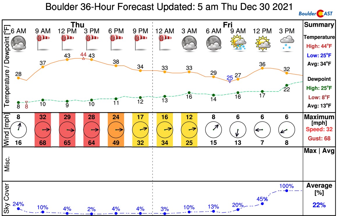
Models have been slowing this storm system down recently so light snow will probably continue into the morning Saturday ending around mid-day. Afterwards, the sun should make an appearance in the afternoon, but it won’t help to warm us up much. Look for highs on Saturday in the low to middle teens with fresh snow-cover on the ground helping to reflect the low-angle New Year’s Day sun. Temperatures start to warm up Sunday and beyond with sunshine taking us into early next week.
If we see any need to update the forecast, we’ll put out a quick note Friday morning or afternoon. Be careful traveling in the cold and snowy weather Friday evening and night. The roadways are sure to become slick!
The first snow-covered roadways of the year always seem to spawn a large number of car accidents as everyone seemingly forgets how to drive in the snow. It just so happens this year that annual event will coincide with plenty of drunk drivers on NYE…#COwx
🥂 + ❄️ =🚘💥🚑
— BoulderCAST Weather (@BoulderCAST) December 28, 2021
From all of the BoulderCAST Team,
we wish you Happy Holidays
and a Happy New Year!
Subscribe to receive email notifications for BoulderCAST updates:
We respect your privacy. You can unsubscribe at any time.
Help support our team of Front Range weather bloggers by joining BoulderCAST Premium. We talk Boulder and Denver weather every single day. Sign up now to get access to our daily forecast discussions each morning, complete six-day skiing and hiking forecasts powered by machine learning, first-class access to all our Colorado-centric high-resolution weather graphics, bonus storm updates and much more! Or not, we just appreciate your readership!
Enjoy our content? Give it a share!


You must be logged in to post a comment.