
Our state has benefited greatly from the recent atmospheric river event with snowpack thankfully getting back close to normal for now. However, things remain dreadfully dry east of the Continental Divide. The week ahead will offer generally cooler than normal temperatures across the Denver area with continued Mountain snowfall really piling up. We are also tracking a potential Arctic outbreak and some snow just in time to ring in the New Year. Here’s the latest.
This week’s highlights include:
- Last week’s atmospheric river event in tandem with another decent wave of snow on Sunday has boosted mountain snowpack back closer to normal
- An active pattern remains across the northern Rockies through the week ahead keeping things unsettled in the High Country
- Expect cooler temperatures across the Denver area as well with highs in the 30’s and 40’s most of the week and plenty of sunshine
- Near-continuous light snow will fall in the Mountains through the week with another 1 to 3 feet of snow piling up by the weekend
- Confidence is growing for an Arctic outbreak and some snow to ring in the New Year across the entire Front Range

DISCLAIMER: This weekly outlook forecast is created Monday morning and covers the entire upcoming week. Accuracy will decrease as the week progresses as this post is NOT updated. To receive daily updated forecasts from our team, among many other perks, subscribe to BoulderCAST Premium.

The snow the Mountains needed!
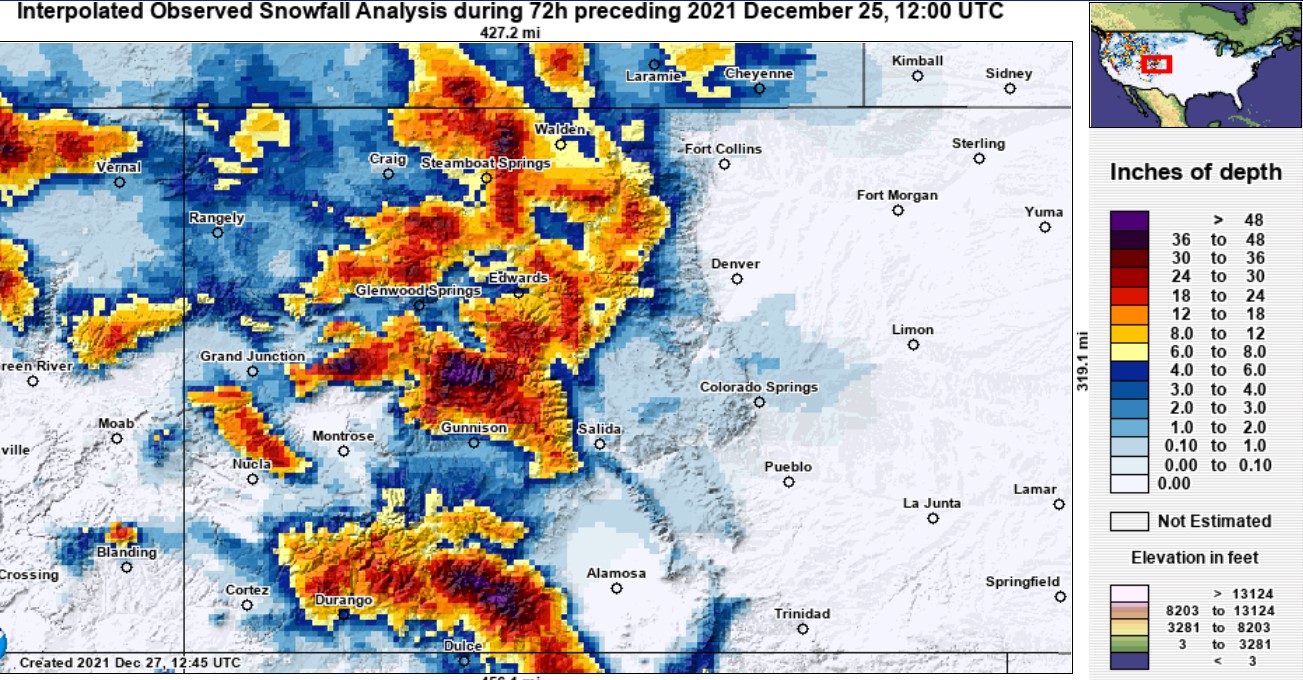
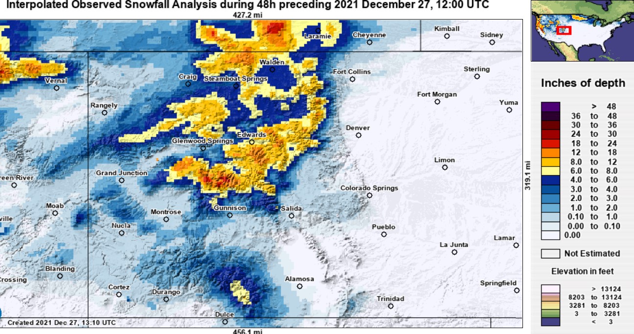
Last week’s atmospheric river (AR) delivered widespread snow to the Mountains as promised which definitely needed it more than ever. Up to 4 feet of snow was reported leading into Christmas morning in parts of the High Country. The map below below shows interpolated snowfall totals ending Saturday morning. The Sawatch and San Juan ranges were favored since this was an AR event driven mainly by moist southwesterly flow.
As expected, this event didn’t bring much more than a few raindrops to the Denver Metro area Friday afternoon as a few bands of precipitation associated with the main cold front moved through. Had the timing been a little better — not the middle of the afternoon — this rain may have mixed over to snow. Rain, in the absence of any snow at all, is actually quite rare in the month of December for us. In fact, since 1949 there were only about twenty occasions where it just rained in Boulder, but did not snow in the last month of the year.
Yesterday on Christmas Eve #Boulder reported 0.04" of rainfall and NO snow. This is only the 20th time in the last 73 years rain was reported without snow in the month of December! 😮
Here's are the other 19 times: #COwx pic.twitter.com/HTy0khagt0
— BoulderCAST Weather (@BoulderCAST) December 25, 2021
The same rain bands that moved through Denver Friday afternoon were actually just cold enough for snow along the Palmer Divide to the south in the evening. As a result, these areas awoke to a white Christmas! The GOES-East visible satellite image below is from just after sunrise on Christmas Day. Note the fresh dusting of snow between Denver and Colorado Springs!
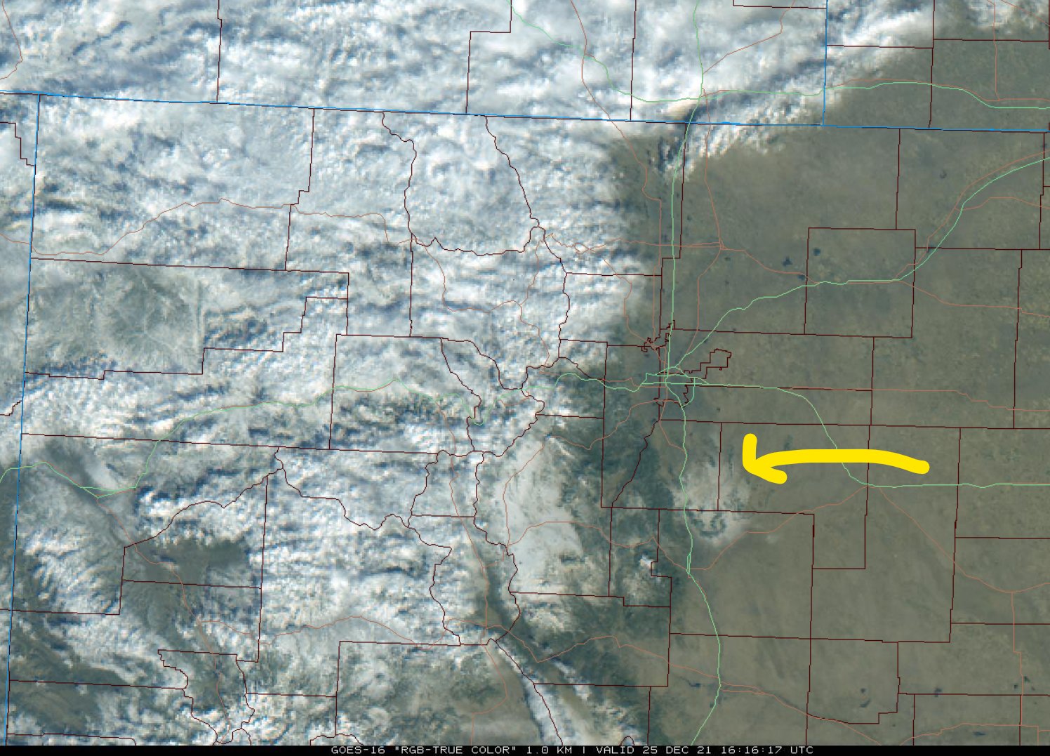
GOES-East visible satellite image from Christmas morning reveals a dusting of snow over the Palmer Divide
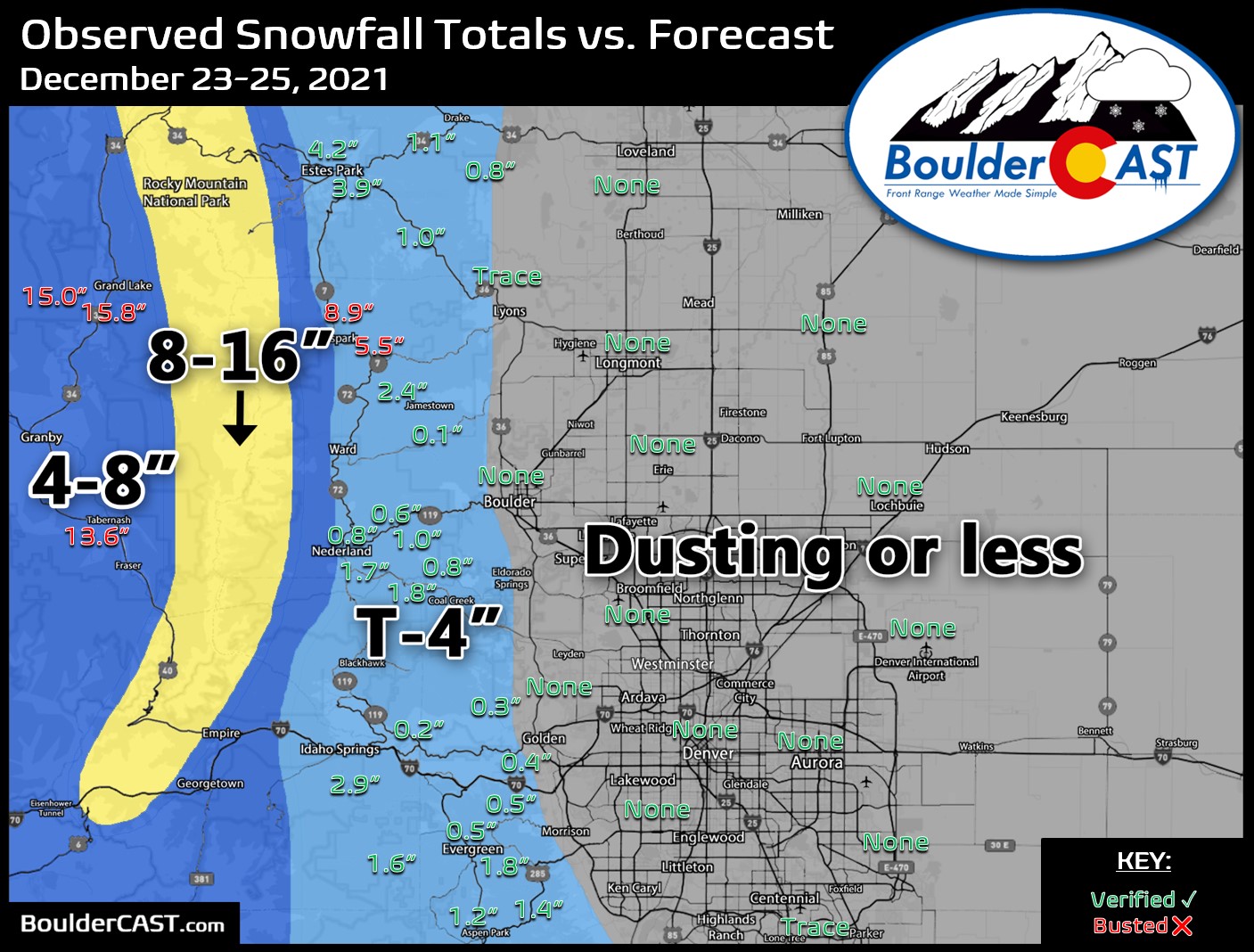
Our snowfall forecast map for the AR event is shown below. Green values indicate that our forecast verified to within one inch of the observed snowfall total. Red numbers did not. Overall, things east of the Continental Divide played out about as we had expected with basically no snow across the Plains and a few inches in the higher Foothills. However, booming totals were observed to the west in Grand Valley where more than a foot of snow dumped somewhat unexpectedly. If you found your way onto the slopes this weekend, you were certainly greeted with bountiful snow. However, you probably found it wasn’t quite the powder you were hoping for. These AR events are incredibly moist but also infused with warm subtropical air resulting in a notably “soupier” snow consistency.
Later on Sunday a more typical shortwave disturbance for the wintertime dropped across northern Colorado bringing another round of welcomed snow to the Mountains, but mainly just gusty winds to the Plains. This wave spawned several heavy snow squalls which created whiteout conditions at times in the Mountains. That National Weather Service issued several Snow Squall Warnings during the day. The image below is from Berthoud Pass Sunday afternoon as the squall moved through!
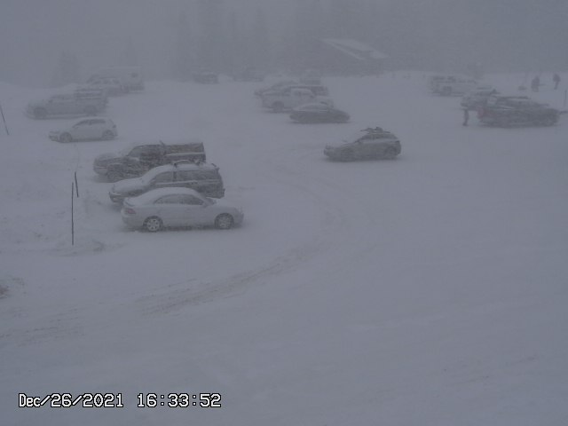
Berthoud Pass on Sunday (12/26/21) afternoon as a snow squall moved through
This secondary wave dumped another 6 to 12″ in the Mountains.
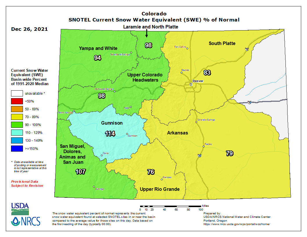
Whew! Not a bad week at all in the Mountains. Anywhere from 1 to 5 feet of snow fell between the two systems. This put a big dent in the snowpack deficit statewide, as seen in the SNOTEL graphic below. While not perfect, we’re a lot closer to normal now that we were just one week ago. Many basins are very close to normal, while those east of the Divide remain lacking.
More snow in the Mountains this week!
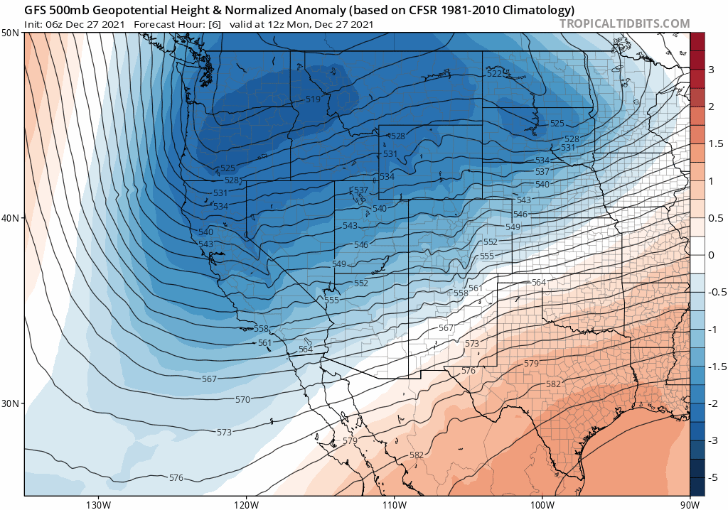
The upcoming week will largely be quiet for the Boulder-Denver area, though something interesting may develop as we head towards the New Year. First off, temperatures won’t be extraordinarily warm this week with more seasonal and even below normal values expected. This is because a persistent trough pattern will remain locked across the northern Rockies through the week. The GFS 500mb height anomaly forecast animation through Saturday is shown below. Note the continuous blue shading over Colorado throughout the animation indicating below normal heights (troughing). Though it hasn’t been the case of late, this type of pattern is very typical this time of year and leads to cooler temperatures for the area.
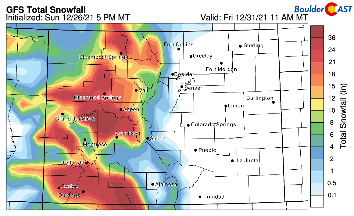
Overall we will end up just northward of the polar jet stream through the week with several pulses of energy and moisture moving through in the west-northwest flow. This pattern will favor near-continuous light snowfall in the Mountains with occasional moderate bursts, but mainly just dry and breezy conditions across the Denver Metro area. The prolonged period of snowfall under this pattern will certainly add up by week’s end. The GFS, for example, is showing another 1 to 3 feet of snowfall through mid-day Friday in the Mountains.
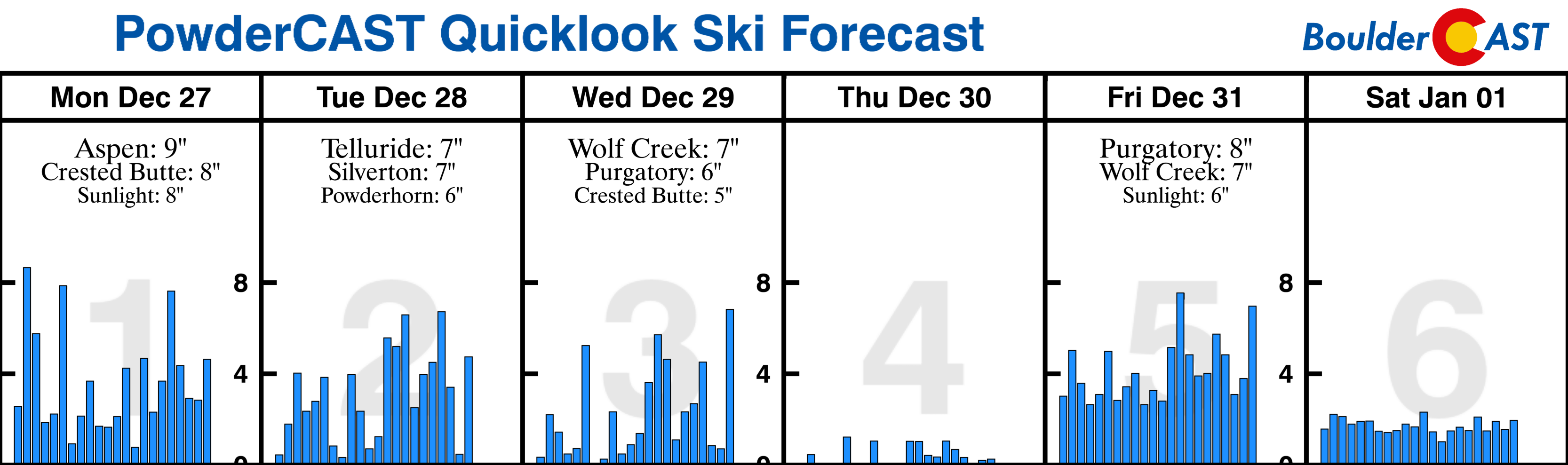
For the skiers, you really can’t go wrong this week as snow will likely be falling in most resorts no matter the day. PowderCAST is indicating 2-8″ of new snow each calendar day this week, with perhaps Thursday bringing a slight lull in the action.
As mentioned, things will be quiet around Boulder and Denver for the most part with near to below normal temperatures under the continuous trough pattern. Expect highs generally in the 30’s and 40’s with plenty of sunshine.
Ringing in the New Year with an Arctic blast?
The most exciting weather of the week comes as we close out 2021 on Friday. We have growing confidence from a plethora of model agreement that a surge of Arctic air will arrive just in time to ring in the New Year across the Denver Metro area. A bitter cold Arctic airmass has been lingering right along the United States-Canada border the last few days bringing record cold to parts of Washington and Montana. A stronger late-week storm appears to perturb things just enough to draw this frigid air southward and across eastern Colorado. The GFS (shown below) slams the Arctic front through the Front Range during the day Friday. The solution currently indicated by other models is very similar, so we’re moderately confident that this cold air outbreak will materialize. However, we are still four to five days out from this potential front, so things can certainly change — most likely that would be the timing.

Right now we can expect Friday’s high temperature to occur in the first half of the day and be somewhere in the 40’s to lower 50’s. Once the front blows through, temperatures will fall off a cliff. The GFS is showing a reading at midnight Friday night of 21°F in Denver, while the Euro is down to 19°F. Models usually don’t bring down temperatures fast enough with these types of fronts, so we would expect temperatures to be even colder than this. Wind chills would be near or below zero so plan on bundling up for any New Year’s outdoor plans!
Cold air then continues to filter in through the day Saturday leading to daytime high temperatures in the teens or 20’s on New Year’s Day followed by potential below zero lows Saturday night. Again, the exact magnitude of this cold air outbreak for the Front Range is not clear at the moment. It’s still too far out. For example, the GFS ensembles (below) are showing a wide spread in high temperatures on Friday — anywhere from the single digits to the upper 30’s. The ensemble average is in the low 20’s!
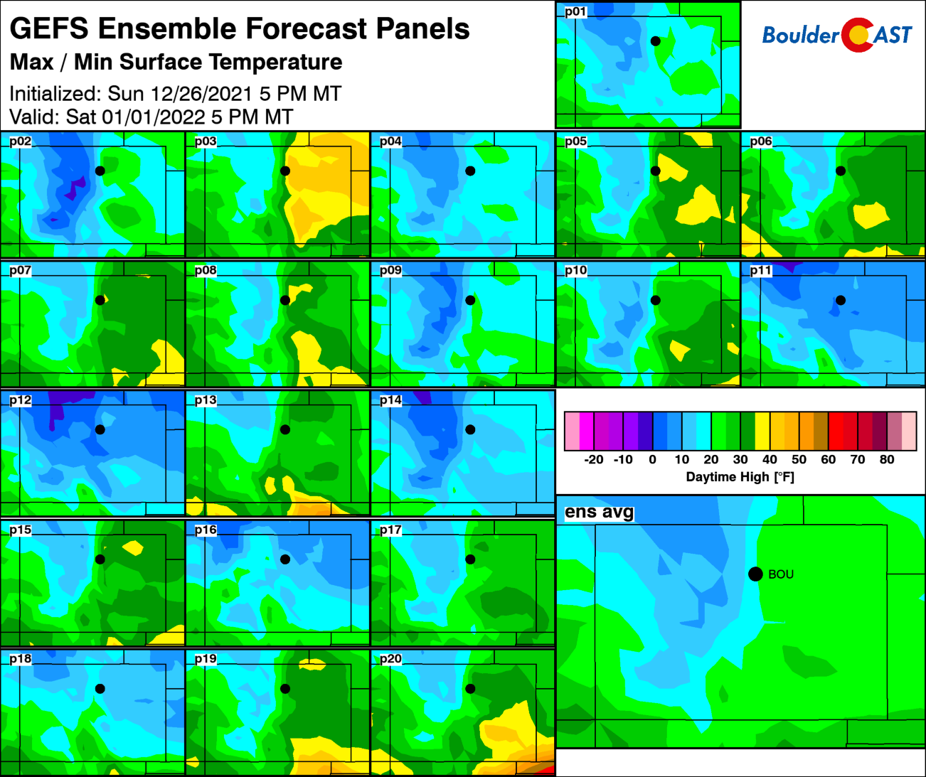
GFS ensemble panel forecast for high temperatures on Saturday (1/1/2022)
Finally, the cold air likely won’t arrive without the threat of snow to end the week. The Arctic front should produce widespread snowfall up and down the Front Range as well — perhaps our most solid chances for white stuff so far this season. As if so often the case with these type of events, a brief moderate wave of snow should accompany the front (possibly mixed with rain briefly at the onset) followed by several hours of lighter upslope snow with fluffy snow ratios as the bitter cold air permeates the area.

The deterministic GFS and Euro models (below) are indicating 3 to 6″ of snow for the area assuming 10:1 snow-to-liquid ratios. This is likely an underestimate considering the colder air involved. However, the model ensembles are trending surprisingly lower than this so don’t get too fixated on the exact amount of snow just yet. However, it’s a fairly safe bet to assume we will see a round of accumulating snow to end the week which will likely be the most substantial so far this season in many locations. Stay tuned…

Stay up to date with Colorado weather and get notified of our latest forecasts and storm updates:
We respect your privacy. You can unsubscribe at any time.
Forecast Specifics:
Monday: Increasing clouds with highs in the middle 40’s on the Plains and lower 30’s in the Foothills. Isolated snow showers may spill into the Metro area late Monday night with little to no accumulation expected.
Tuesday: Partly cloudy and cooler with highs in the middle 30’s on the Plains and middle 20’s in the Foothills.
Wednesday: Chilly but mostly sunny. Temperatures in the lower 30’s across the Plains with lower 20’s in the Foothills.
Thursday: Mostly sunny and seasonal with highs in the middle 40’s for the Plains and lower 30’s in the Foothills.
Friday: Keep an eye on Friday as an Arctic front is projected to move through during the day. Expect a mild morning with highs somewhere in the 40’s to lower 50’s, then a gusty front with tumbling temperatures in the late-day period. Temperatures are expected right now to drop considerably through the evening with wind chills possibly below zero by midnight for the New Year. Accumulating snow will likely accompany the front with several inches possible across the Denver area.
Mountains: An active troughing pattern across the northern Rockies this week will spell out near-continuous light snowfall in the Mountains with a few heavier surges of moderate snowfall mixed in. Thursday may offer a lull in the action somewhat. Through the week, expect 1 to 3 feet of additional snow in most Mountain areas with no real favored ranges. Temperatures remain below normal through the week with gusty winds as well thanks to the nearby jet stream.
Help support our team of Front Range weather bloggers by joining BoulderCAST Premium. We talk Boulder and Denver weather every single day. Sign up now to get access to our daily forecast discussions each morning, complete six-day skiing and hiking forecasts powered by machine learning, first-class access to all our Colorado-centric high-resolution weather graphics, bonus storm updates and much more! Or not, we just appreciate your readership!
Spread the word, share the BoulderCAST forecast!


You must be logged in to post a comment.