The well-advertised late-week winter storm delivered widespread wet snow to the entire Denver Metro area and nearby Foothills Thursday into Saturday, with some rain mixing in at times across the warmer northern tier. We review the soupy snowfall totals from this final bout of winter weather that put a bow on the lengthy cold and snowy week in the Front Range. We also discuss the shift back to sunny and dry conditions for the upcoming week.
Category: Verification (Page 7 of 51)
These posts take a look back at recent weather events, like snow storms or severe weather outbreaks, and evaluate how the forecast played out. We evaluate how well the models predicted what actually occurred, and offer insight into what can be learned and applied moving forward.

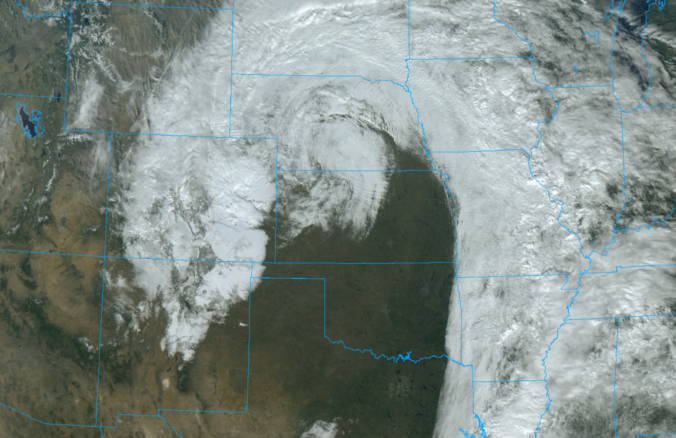
A prolonged period of light to moderate snow fell across most of the Denver Metro area Tuesday evening into Wednesday evening. We briefly review the booming snowfall totals from the first real dump of snow in the nascent 2024-25 season!
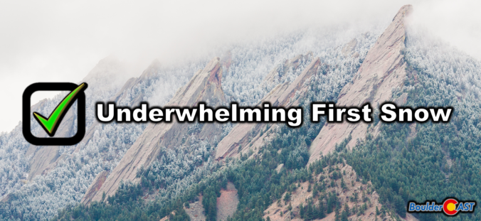
Many western suburbs of Denver experienced their first snow of the season last night, with Boulder officially recording 0.2 inches. The colder, higher elevations to the west saw a more significant dump, up to 15 inches in some areas. We briefly recap the underwhelming first snow of the season and announce the winners of our 2024 First Snowfall Contest.
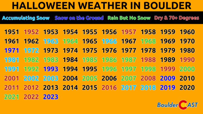
As we transition deeper into autumn season, Colorado weather continues to keep us all on our toes. This past weekend, a slow-moving storm system that was expected to bring widespread light precipitation to the Denver Metro area ended up being a tad underwhelming, with the bulk of the moisture staying to our south. While Boulder and Denver received only minimal rainfall, areas of southern Colorado and New Mexico experienced heavy rainfall which led to deadly flash flooding. Looking ahead, this week promises relatively quiet weather for the Front Range, with just a brief cool down scheduled for late week. We’re also tracking an interesting storm in the pipeline for next week which could bring sub-freezing temperatures and potentially some snow to the area just in time for Halloween.
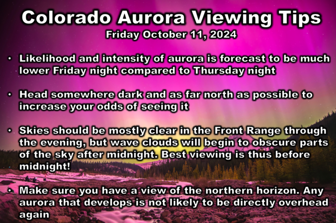
The Northern Lights put on a spectacular show across the Front Range Thursday night, and there’s a chance for an encore performance tonight! While the display is not likely to be as intense or widespread Friday night, mostly clear skies and comfortable temperatures will make it a perfect evening to try your luck in the Denver Metro area. Read on for our team’s recommendation on the best time and place to head out to take in the Northern Lights Friday night in Colorado!
The Front Range experienced its first significant rainfall in five months, with some areas receiving up to an inch of rain over the weekend. The start of the work week will be relatively cool. However, a strong ridge pattern known as an omega block will bring warm and dry conditions from Wednesday onwards, with temperatures rising into the 80s and potentially reaching record highs by Thursday. While there is no hope for any snow in our forecast yet, our 10th Annual First Snow Contest will open to entries later this week. Read on for all the details.
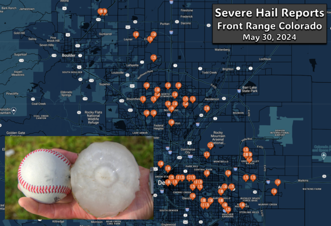
A pair of severe, supercell thunderstorms exploded across the northern Front Range late Thursday evening with very little advanced notice for residents. Hail larger than baseballs caused significant property damage on the northern and northeastern Metro area — roofing, siding, car windows and gardens stood no chance against the onslaught. The hail repair and insurance scammers are probably already knocking on doors this morning or making cold calls! We take a look at where the largest hail fell and why the forecast was so poor.

Live View of Boulder

Current Conditions

Live Radar

Recent Premium Posts

BoulderCAST Daily – Sun 12/14/25 | A warmup after the chilly yesterday afternoon
🌡️ Warmth Returns with no sight of snow: Highs return close to 60 …
BoulderCAST Daily – Sat 12/13/25 | Highs in the 60s this weekend!
🌡️ October Warmth in December: Highs typical for late October will be in …
This Weekend in Colorado Weather: The December that has felt like October continues with bone dry warmth persisting into next week
🌬️ Two more breezy days ahead with gusts 15–25 MPH before the jet …
3-Day Forecast

Trending Content

© 2025 Front Range Weather, LLC