With the Great Arctic Blast of 2024 starting to wrap up across Front Range Colorado, the weather week ahead will be comparatively less eventful. However, there are multiple disturbances lined up in the coming days which will bring waves of moderate to heavy snow in the Mountains as well as a small chance of wintry precipitation to the Metro area. A thawing trend will ensue in the coming days, but temperatures won’t get back above normal until late in the weekend or early next week.
This week’s highlights include:
- The Arctic airmass loosens its grasp Tuesday into Wednesday with temperatures warming into the 30s and then 40s
- Moderate to heavy Mountain snow returns Wednesday and Thursday with storm totals of 6 to 14″ expected in the central and northern mountain ranges
- A strong cold front will drop south across eastern Colorado Thursday afternoon with a slight chance of light snow and gusty winds
- Much colder weather expected Friday behind the front with highs only in the 20s
- A shortwave ridge enters Colorado this weekend with calm conditions expected statewide — lots of clouds will be around, but we warm up into the 40s and maybe even 50s
DISCLAIMER: This weekly outlook forecast is created Monday morning and covers the entire upcoming week. Accuracy will decrease as the week progresses as this post is NOT updated. To receive daily updated forecasts from our team, among many other perks, subscribe to BoulderCAST Premium.

Go Premium, get all the perks.
Daily Forecast Updates
Get our daily forecast discussion every morning delivered to your inbox.
All Our Model Data
Access to all our Colorado-centric high-resolution weather model graphics. Seriously — every one!
Ski & Hiking Forecasts
6-day forecasts for all the Colorado ski resorts, plus more than 120 hiking trails, including every 14er.
Smoke Forecasts
Wildfire smoke concentration predictions up to 72 hours into the future.
Exclusive Content
Weekend outlooks every Thursday, bonus storm updates, historical data and much more!
No Advertisements
Enjoy ad-free viewing on the entire site.
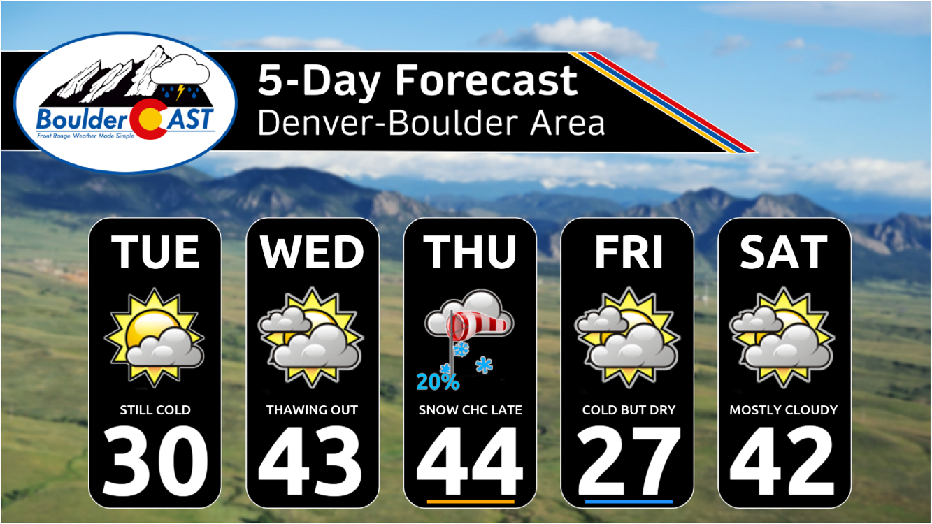
Warming up this week, but not that warm!
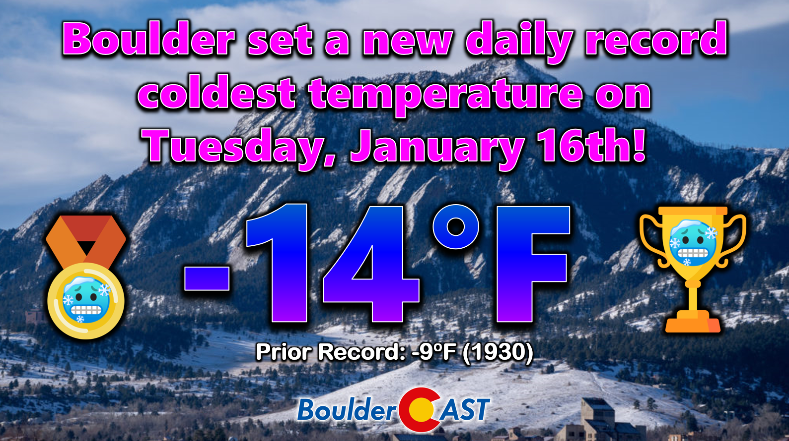
As of Tuesday morning, what is likely the coldest weather of the entire 2023-24 winter season is almost now behind us. We’re already starting to see some “warm” downslope flow erode the Arctic airmass across portions of the Denver Metro area. There are still lots of negative temperature readings out there, including some bone-chilling -30s along the South Platte River east of Greeley, but warmer downslope flow is starting to invade the western fringes of town with positive temperatures for areas in and near the Foothills. The warmest readings early Tuesday are in the teens and even lower 20s around Rocky Flats and Broomfield Airport, two typically downslopey areas.
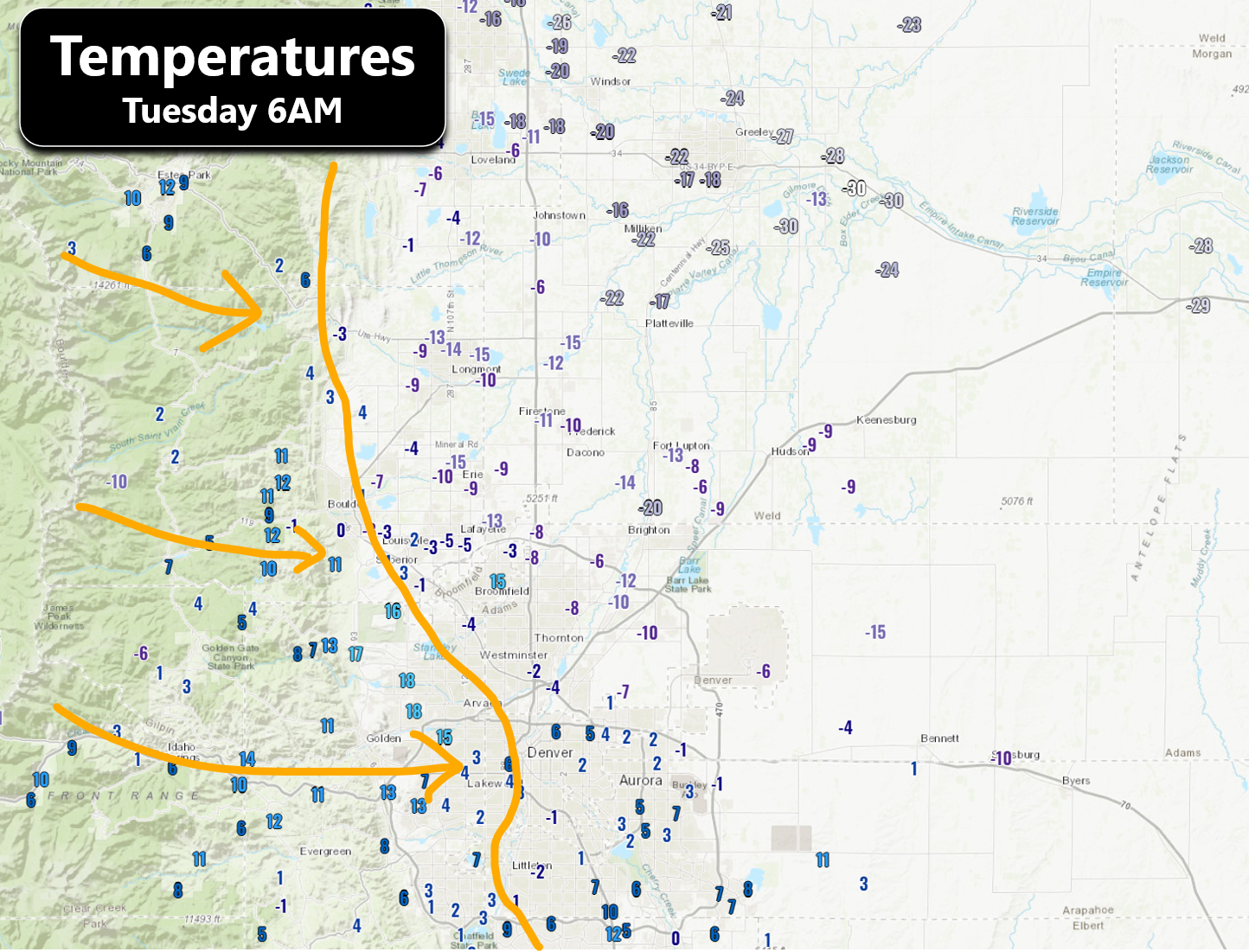
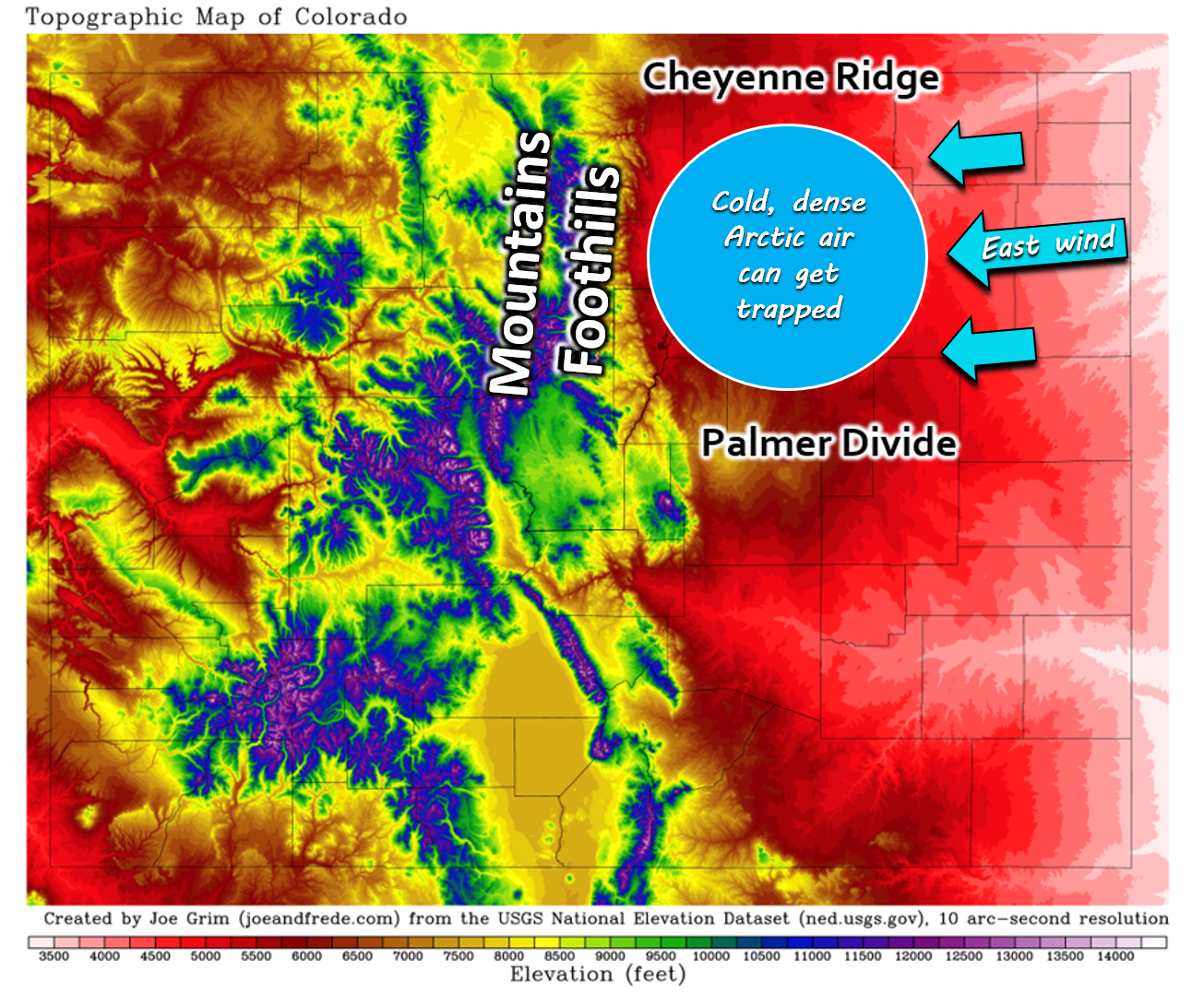
Temperatures following an Arctic blast can sometimes be stubborn to recover across the Front Range, owing mainly to the cold, shallow and dense nature of Arctic air which can be difficult to erode out of the Denver Metro area’s all-encapsulating topography. We’ve got terrain substantial enough to trap Arctic air to the north, west and south. The only real exit is eastward, but if there is anything in the way of easterly flow, this door can be closed and our warm-up will be very slow. Throw in a blanket of fresh snow on the ground, which further reduces the temperature recovery, and Arctic air can linger long past its shelf date in some cases.
With that said, fortunately it does look like the warm-up this week will occur somewhat rapidly, at least by post-Arctic blast standards, thanks to downslope flow! As we showed earlier, we’re already seeing downslope flow working to oust the Arctic air from the west before sunrise on Tuesday and this trend will continue through Tuesday and Wednesday.
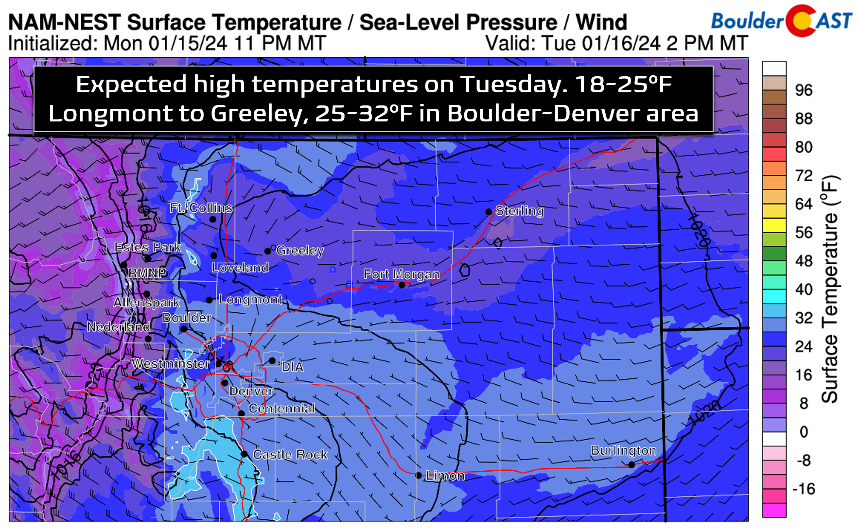
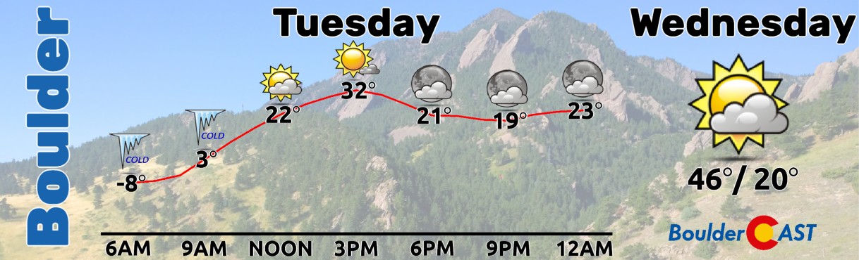
We’re expecting highs on Tuesday to land in the lower 30s in the Denver area, with lower 20s further north towards Greeley. Skies will be partly to mostly sunny.
As the week progresses, an active northwest flow pattern will remain across Colorado, with two disturbances moving through in the coming days — one Wednesday and another on Thursday. These will primarily produce continued moderate to heavy Mountain snowfall, but there will also be a slight chance of snow across the lower elevations as well with the secondary system on Thursday. It’s not until the upcoming weekend when we finally see reliable signals for a ridge moving into the area which will put an temporary hold on Mountain snow and lead to notably warmer temperatures in the Metro area.
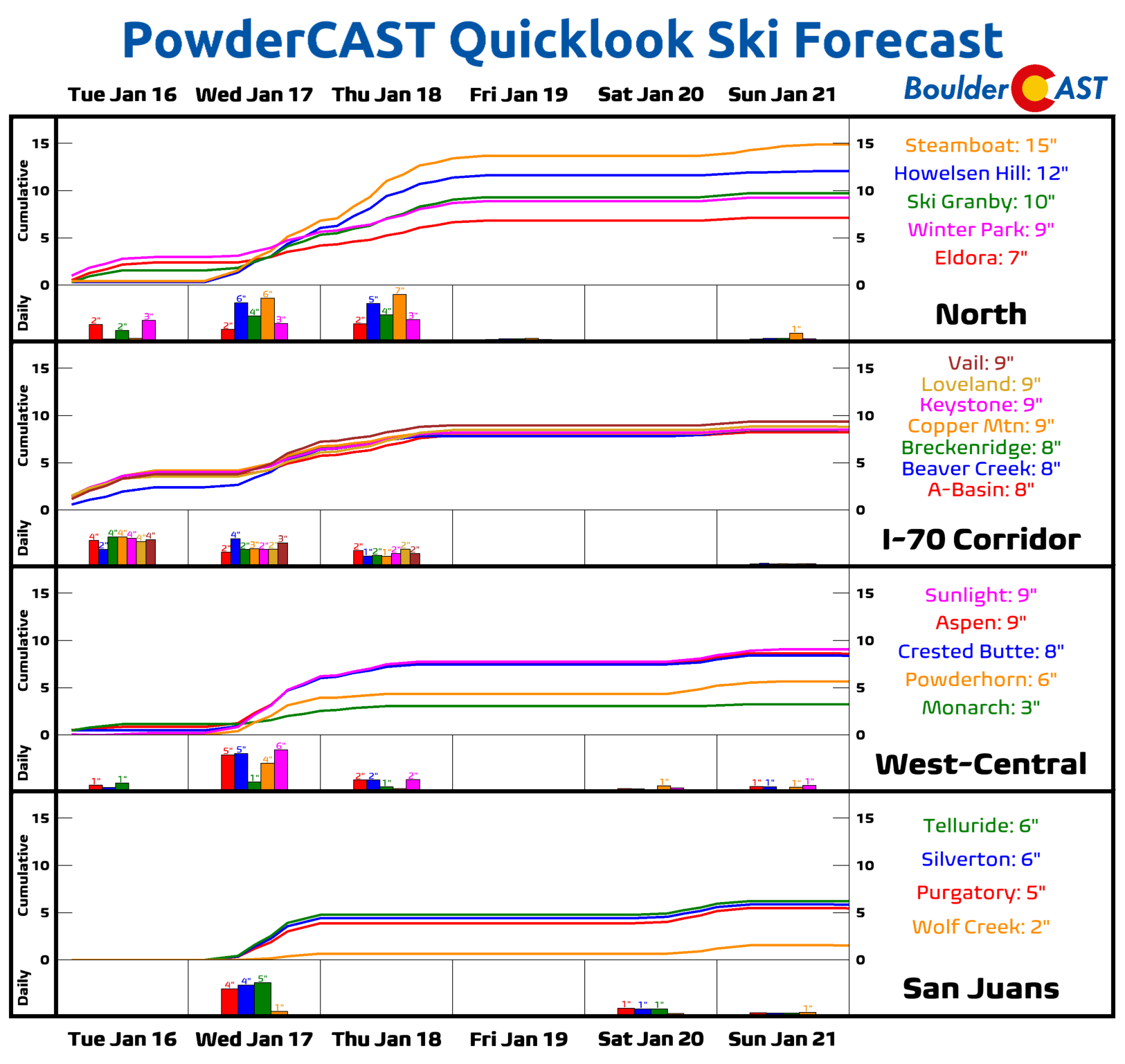
The Mountains will see two main waves of snow this week as moist Pacific flow returns aloft. The first is Wednesday into Wednesday evening. There will be somewhat of a break in the action Wednesday night before another round of lighter snow gets going on Thursday.
This setup will favor the northern Colorado mountain ranges, with Steamboat poised to see more than a foot of new snow by Thursday night. Most central and northern Colorado ski resorts can expect 6-12″ of additional snow this week, with 2-6″ across southern Colorado. This is on top of the two to five feet of snow they already piled up over the last few days!
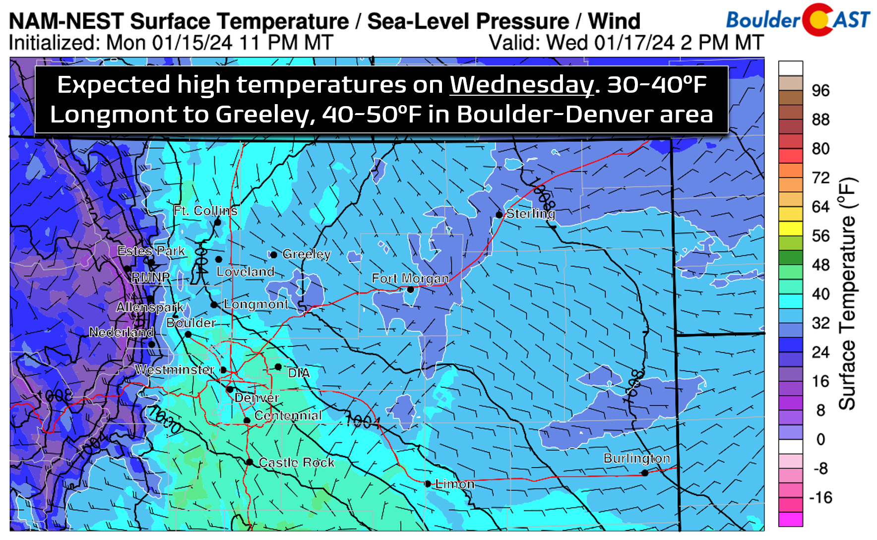
East of the Mountains, we will continue our warming trend on Wednesday with high temperatures pushing into the 40s for most of us, with perhaps even some lower 50s in the less snowy areas like southeast Denver.
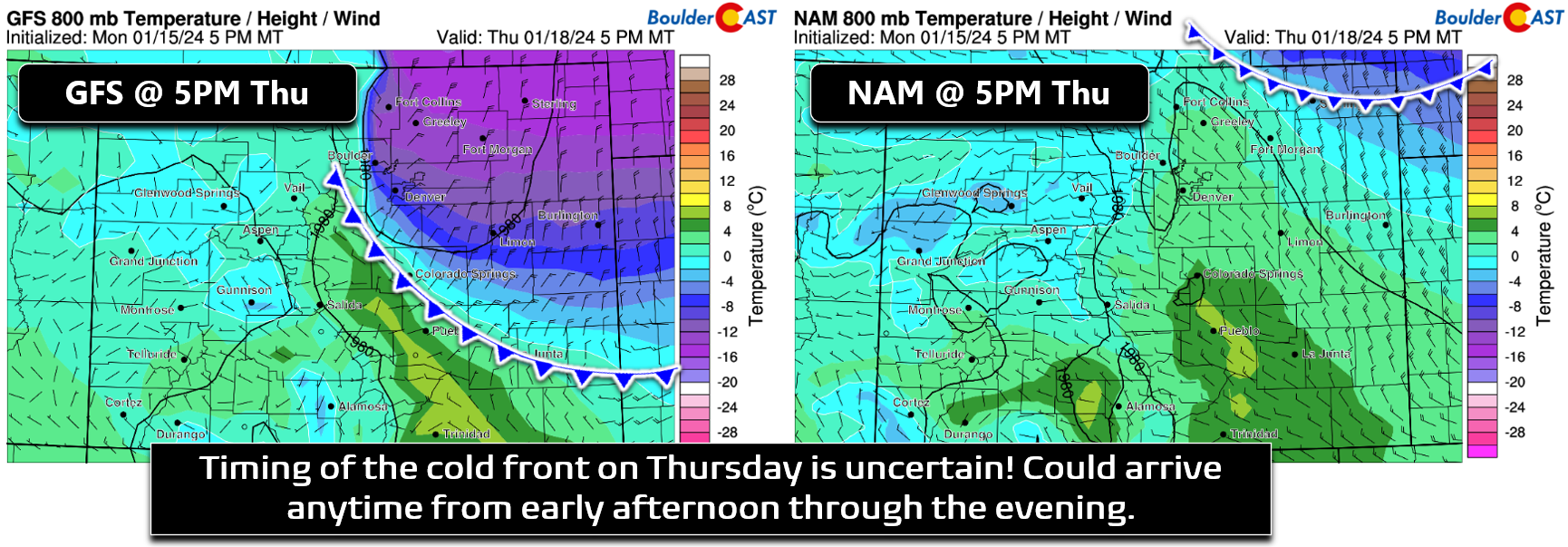
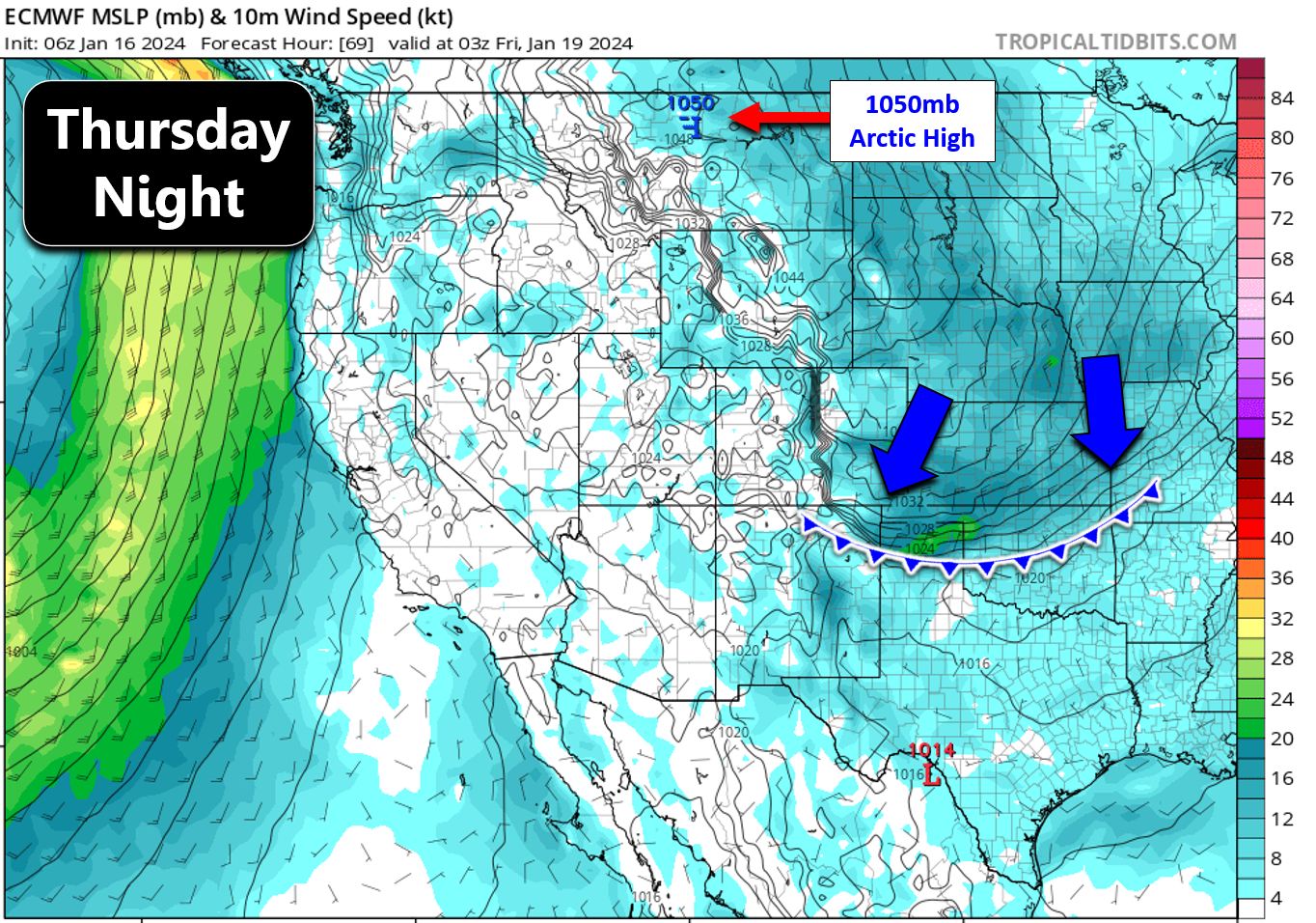
On Thursday, the next storm system will arrive into Colorado from the north and northwest. This one will have a cold front sweeping across the lower elevations sometime late in the day. The timing of this front is particularly uncertain right now, with variations ranging from early afternoon (Euro), to mid-afternoon (GFS), to mid-evening (NAM). The timing of this front will of course have implications on our high temperatures Thursday. This will be another strong front, so we will lean earlier as opposed to later — as that is how these situations typically unfold. Thus, plan on highs in the low to middle 40s on Thursday with those highs occuring around midday or early afternoon. Temperatures will fall quickly into the 20s and teens behind this front with wind gusts of up to 45 MPH possible.
While this second system will bring more white stuff to the Mountains, the snowfall potential down here will be much lower. There’s not a lot of moisture to work with, but there will be some jet energy and minor upslope behind the front. Right now it looks like the best chance of seeing snowflakes will be up around Fort Collins and along the Wyoming Border area, with just a dusting to 2″ possible there. Further south in Boulder and Denver, we may see a brief wave of light snow Thursday evening or night, or perhaps nothing at all.
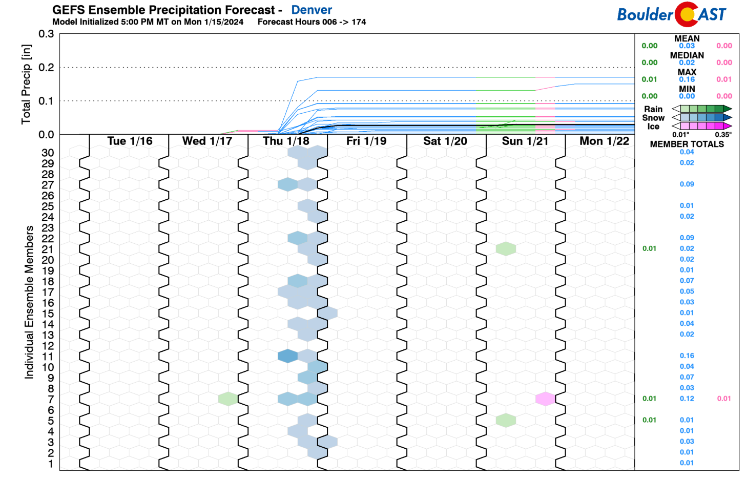
A potent 1050mb Arctic high pressure is coming in behind the front on Thursday, something that would typically favor at least some precipitation in our area — be it light snow or freezing drizzle. Either way, wintry precipitation won’t be a huge concern from this system with at most a dusting to 1″ expected in the Metro area, or a light glaze of ice. The bigger story late-week will be the return of cold temperatures — highs on Friday will drop back into the 20s across the Front Range but with dry conditions.
The aforementioned ridge will work into the area on Saturday from the west bringing broadly quiet weather to the Centennial State.
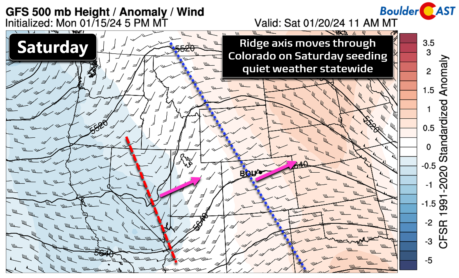
With this, expect high temperatures to rebound back into the 40s for Saturday, with potential 50s possible by Sunday! Here’s a look at the full week ahead:
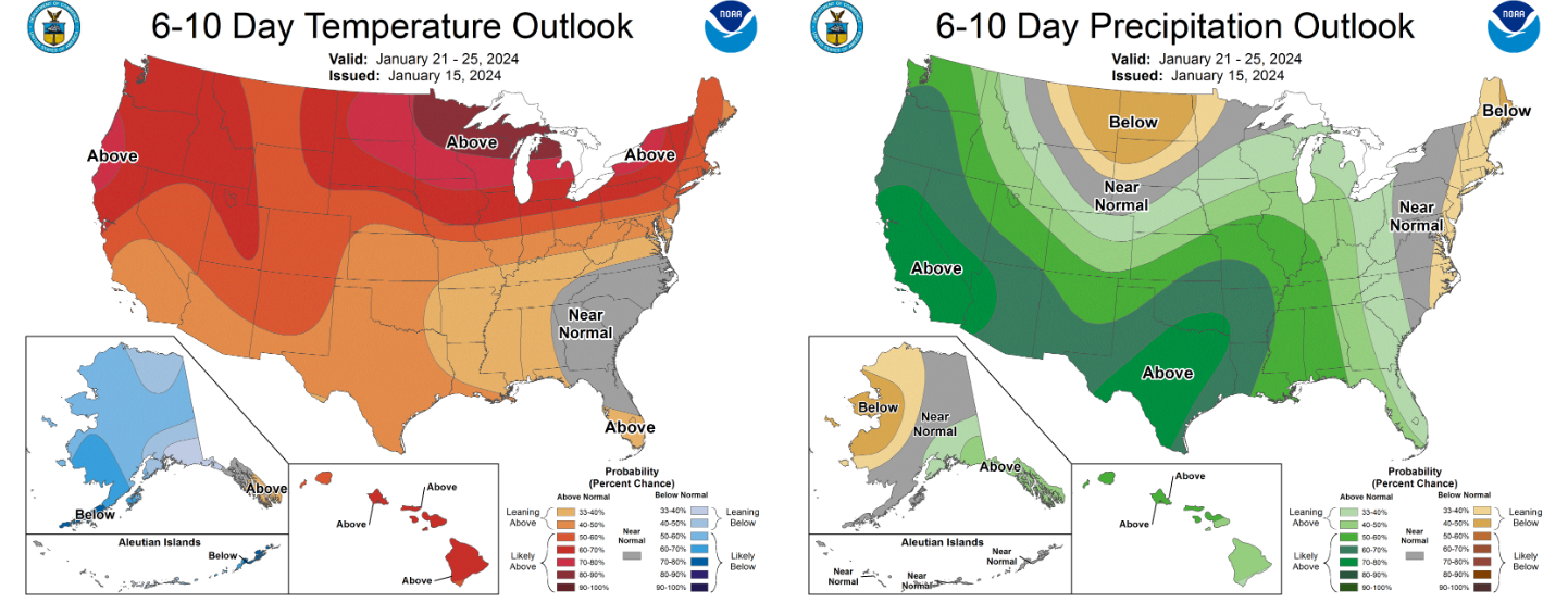
The extended forecast for Sunday into next week is a welcomed warm one as the pattern shifts back towards a more active southern storm track, rather that the recent polar one! The southern tier of the country will be wet while the northern tier will be warm. Colorado, in classic fashion, will be stuck in the middle of both trends with somewhat uncertain weather for next week. Right now nothing looks particularly interesting to us yet, outside of a possible late week light snow chance, but that could change! At least it does appear like we will finally have several days of above normal temperatures.
Personally we are happy about the rather muted stretch of Colorado weather this week and some of next. It’s been a long last seven days planning for and forecasting the (now) departing Arctic blast. We’ll be taking this time to recharge for the inevitable next onslaught of winter weather into the Front Range. Enjoy!
Get BoulderCAST updates delivered to your inbox:
Forecast Specifics:
Tuesday: Very cold in the morning (below zero), but warming up nicely during the day. Highs in the low to middle 30s, but colder north. The Foothills will also be in the 30s.
Wednesday: Downslope flow will bring quiet conditions east of the Mountains with partly to mostly cloudy skies. Winds will be gusty in the afternoon for the western Metro are in excess of 35 MPH. There could be a few spill-over snow showers in the Foothills, but otherwise dry. Highs reach the 40s on the Plains with lower 30s in the Foothills.
Thursday: A cold front will be blasting south across eastern Colorado during the day, most likely arriving to the Denver Metro in the afternoon. Highs will be in the 40s before the front with gusty northwest winds, falling quickly into the 20s and teens behind it with gusty north-northeast winds. A slight chance of snow will develop in the evening and overnight period, mainly closer to the Wyoming Border. Less than 1″ of snow is expected, if anything.
Friday: Mostly cloudy and cold with highs in the mid to upper 20s on the Plains with teens in the Foothills.
Saturday: Warmer but mostly cloudy. Temperatures will return to the 40s across the Plains with 30s in the Foothills.
DISCLAIMER: This weekly outlook forecast is created Monday morning and covers the entire upcoming week. Accuracy will decrease as the week progresses as this post is NOT updated. To receive daily updated forecasts from our team, among many other perks, subscribe to BoulderCAST Premium.
Go Premium, get all the perks.
Daily Forecast Updates
Get our daily forecast discussion every morning delivered to your inbox.
All Our Model Data
Access to all our Colorado-centric high-resolution weather model graphics. Seriously — every one!
Ski & Hiking Forecasts
6-day forecasts for all the Colorado ski resorts, plus more than 120 hiking trails, including every 14er.
Smoke Forecasts
Wildfire smoke concentration predictions up to 72 hours into the future.
Exclusive Content
Weekend outlooks every Thursday, bonus storm updates, historical data and much more!
No Advertisements
Enjoy ad-free viewing on the entire site.
Enjoy our content? Give it a share!


You must be logged in to post a comment.