Warmth, wind, and a whole lot of déjà vu are back on the menu along the Front Range this week. After Sunday’s near‑record heat wiped out most of Friday’s snow, the pattern ahead looks suspiciously like the one we’ve been stuck in all winter — breezy downslope days, a meaningless cold front, and another surge of unseasonable warmth waiting in the wings. Fire danger, early Mountain snowpack melt, and record high temperature records will all come into play as we head deeper into the week and the month of March. Read on for all the details.
This week’s highlights include:
- 🌡️ Near‑record warmth Sunday erased most of Friday’s snow, with only shady patches hanging on as temps surged into the 70s.
- 🌀 Quiet, warm, and windy week ahead as the storm track lifts into Canada and a ridge rebuilds over the Southwest USA.
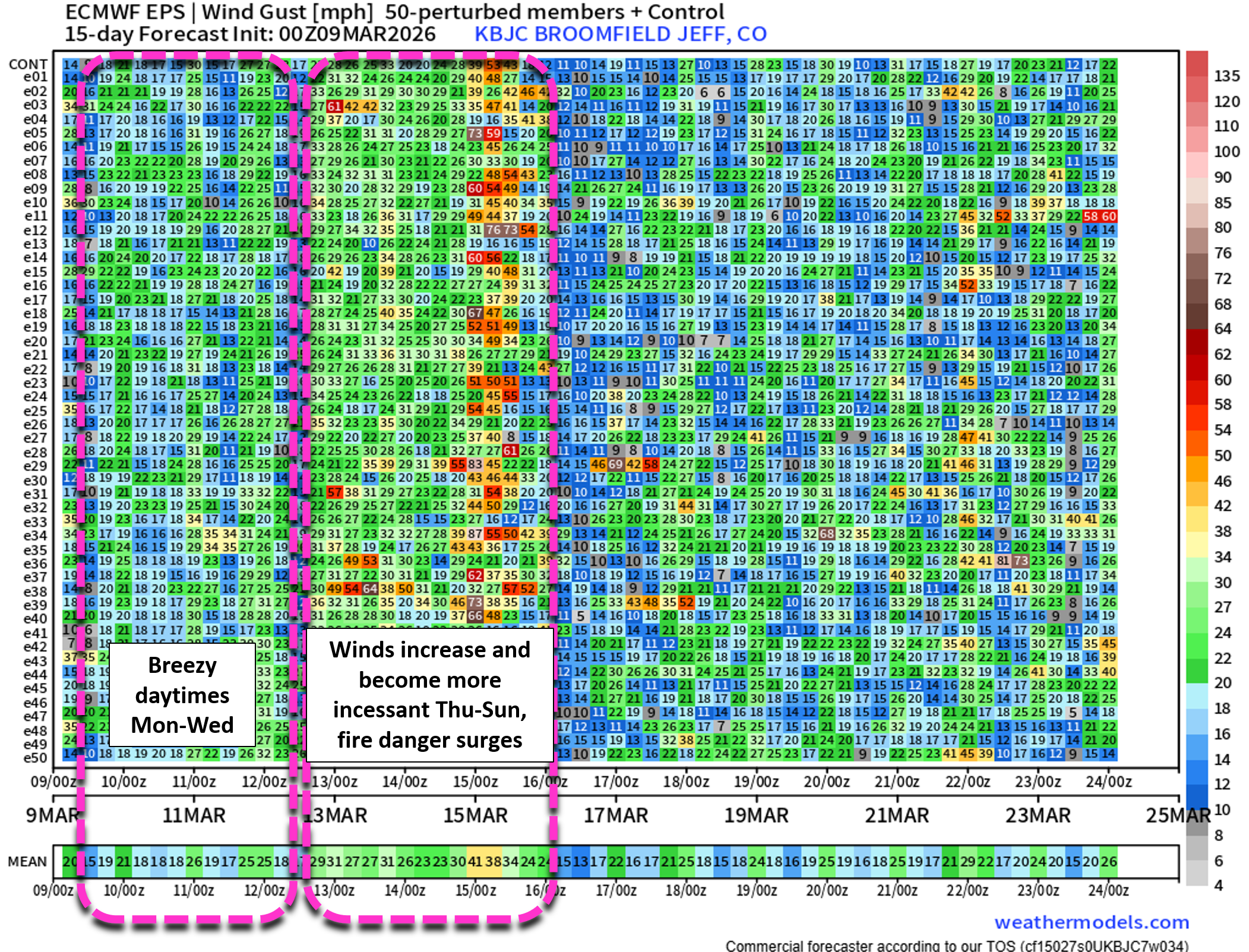
- 🌬️ Monday–Tuesday stay very warm (70s) and breezy, driven by downslope westerlies and a passing cut‑off low to the south.
- ❄️ A weak Tuesday evening cold front brings minimal impacts, with only light snow in the northern Mountains and Denver Metro area highs dropping into the 50s Wednesday.
- 🔥 Fire danger ramps up late week as strong NW flow returns; gusts 30+ MPH and very dry air likely Thursday–Sunday.
- ☀️ Late‑week warmth surges again with upper 60s Thursday and low 70s Friday under skies filled with wave clouds.
- 🌡️🔥 Exceptional heat wave favored next week, with a powerful Four Corners ridge bringing record‑busting heat that will kick off a worrying amount of early Mountain snowmelt.
DISCLAIMER: This weekly outlook forecast is created Monday morning and covers the entire upcoming week. Accuracy will decrease as the week progresses as this post is NOT updated. To receive daily updated forecasts from our team, among many other perks, subscribe to BoulderCAST Premium.

Go Premium, get all the perks.
Daily Forecast Updates
Get our daily forecast discussion every morning delivered to your inbox.
All Our Model Data
Access to all our Colorado-centric high-resolution weather model graphics. Seriously — every one!
Ski & Hiking Forecasts
6-day forecasts for all the Colorado ski resorts, plus more than 120 hiking trails, including every 14er.
Smoke Forecasts
Wildfire smoke concentration predictions up to 72 hours into the future.
Exclusive Content
Weekend outlooks every Thursday, bonus storm updates, historical data and much more!
No Advertisements
Enjoy ad-free viewing on the entire site.
From snow to 70s in the blink of an eye
Thanks to the near‑record warmth over the weekend across the Front Range, the sloppy snowpack left behind by Friday’s storm didn’t stand a fighting chance. Boulder went from a sunrise winter wonderland to a patchy smear of brown by sunset as the snow melted away in a hurry on Saturday, The BoulderCAST sky camera had a front row seat for the rapid melt:
The rest of the Front Range, which received greater snow amounts than Boulder, saw the snow melt reach completion on Sunday. GOES‑East visible satellite imagery from Sunday afternoon tells the story beautifully: a patchwork of white rapidly dissolving across the Denver Metro as temperatures surged into the lower 70s. Only stubborn pockets of snow in shaded areas remain at this point and those scraps will vanish quickly early this week as yet another warm, windy stretch takes hold along the Front Range — a pattern that has become all too familiar this winter.
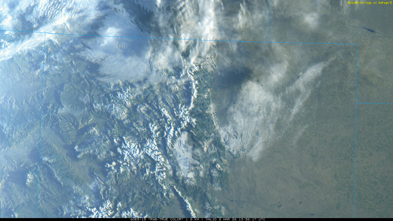
Visible satellite imagery from Sunday showing the snow melting off
The week ahead: Warm & windy
After several active weeks of healthy Mountain snow and finally a meaningful dose of moisture for the lower elevations, Colorado is slipping back into a quieter pattern for much of the upcoming week. The broader setup looks eerily similar to the winter theme we’ve been stuck in: the storm track lifting north into southern Canada while a persistent ridge rebuilds over the southwestern United States.
The Euro model’s 500mb animation below captures the big‑picture:
- Monday and Tuesday: Warm, zonal flow dominates as a cut‑off low — a leftover fragment of Friday’s storm — drifts by to our south.
- Tuesday night: A weak trough brushes the Canadian border, sending a mostly dry cold front southward into Colorado.
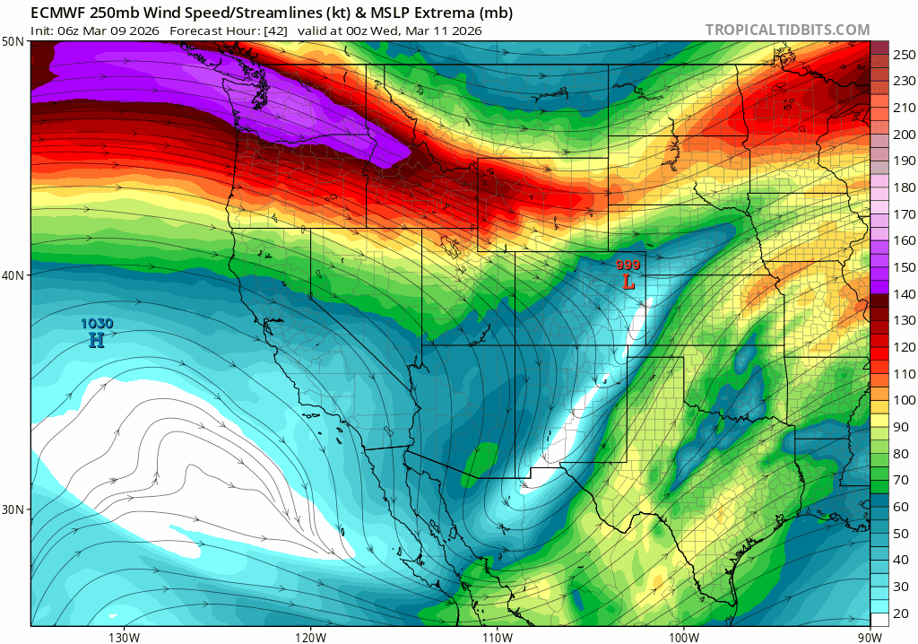
- Late week: The ridge strengthens over the Southwest, tightening the height gradient and cranking up strong northwest flow across the state.
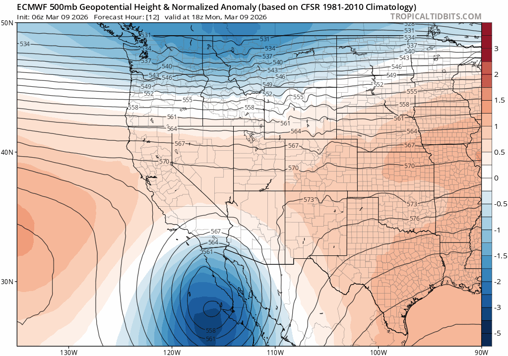
Euro 500mb height anomaly forecast through Friday
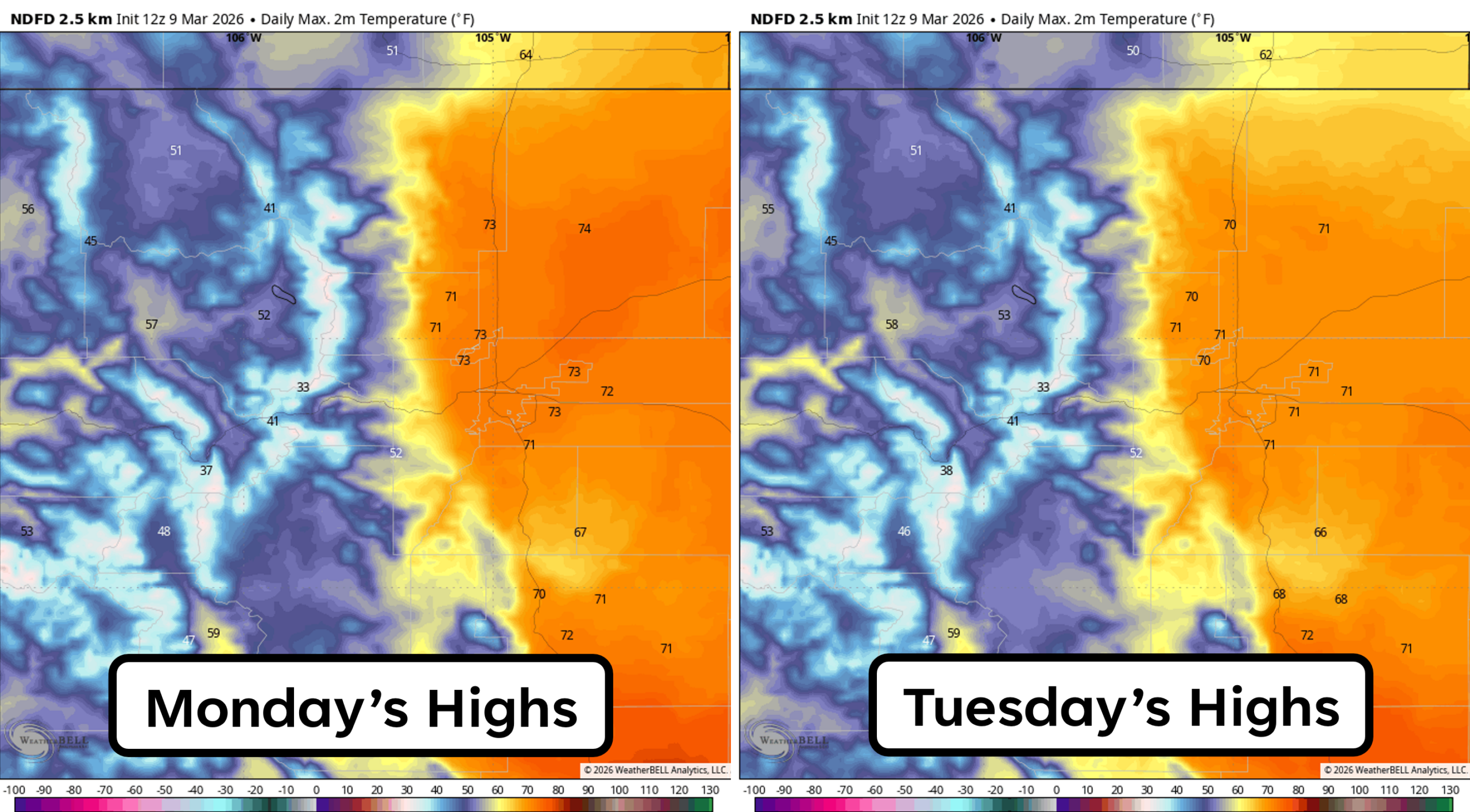
Very warm early week
Downslope westerlies will be the main driver Monday and Tuesday, delivering another round of springlike warmth. Highs will easily climb into the lower and middle 70s both days — a full 15° above normal for early March. Winds will be breezy but not extreme, with gusts generally topping out around 25 MPH during the afternoons.
The one silver lining: lingering moisture from Friday’s snow will keep fire danger tamped down for now. But that reprieve won’t last long.
Midweek cooldown
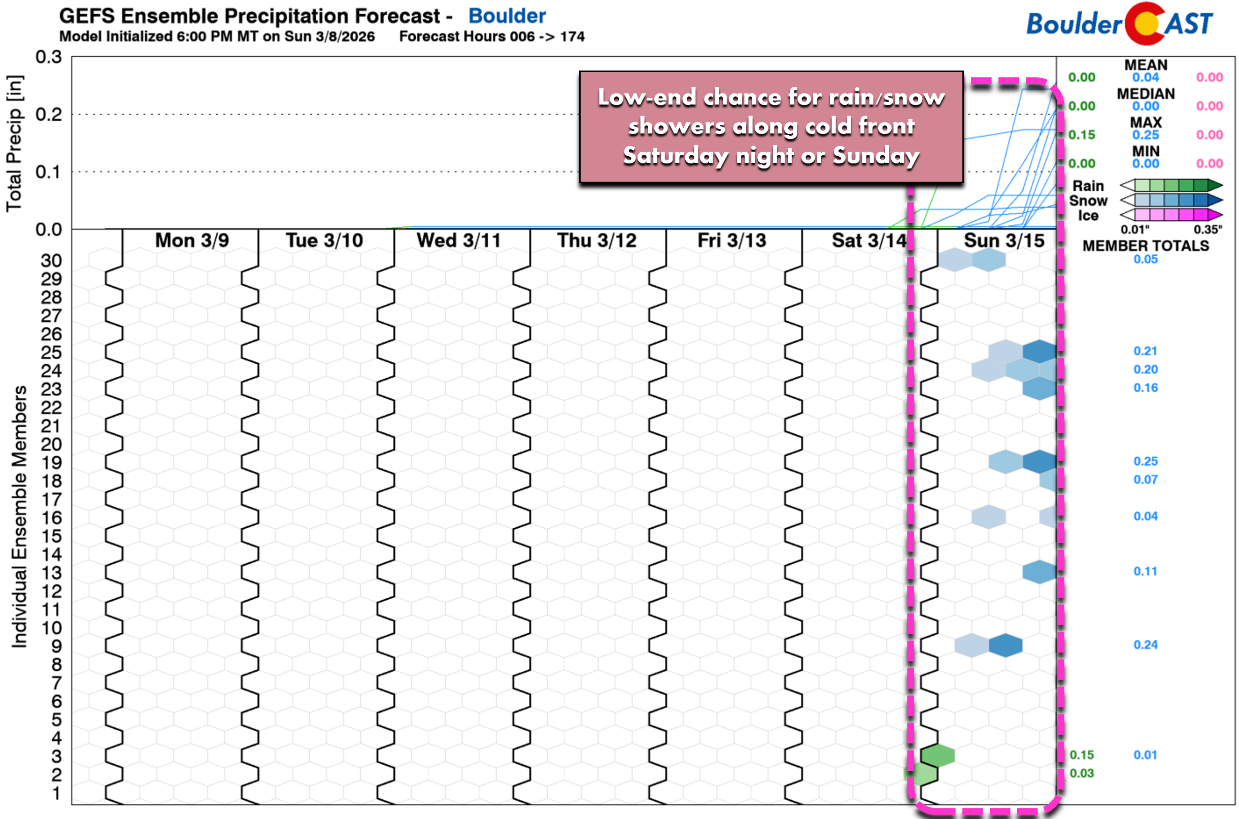
Our only cold front of the week arrives sometime around sunset Tuesday. It’s tied to a weak disturbance passing well north of Colorado near the Canadian border, so impacts here will be minimal. A few spotty rain showers may develop along the Wyoming state line as the front slides through, but the odds of measurable precipitation in Boulder or Denver are extremely low.
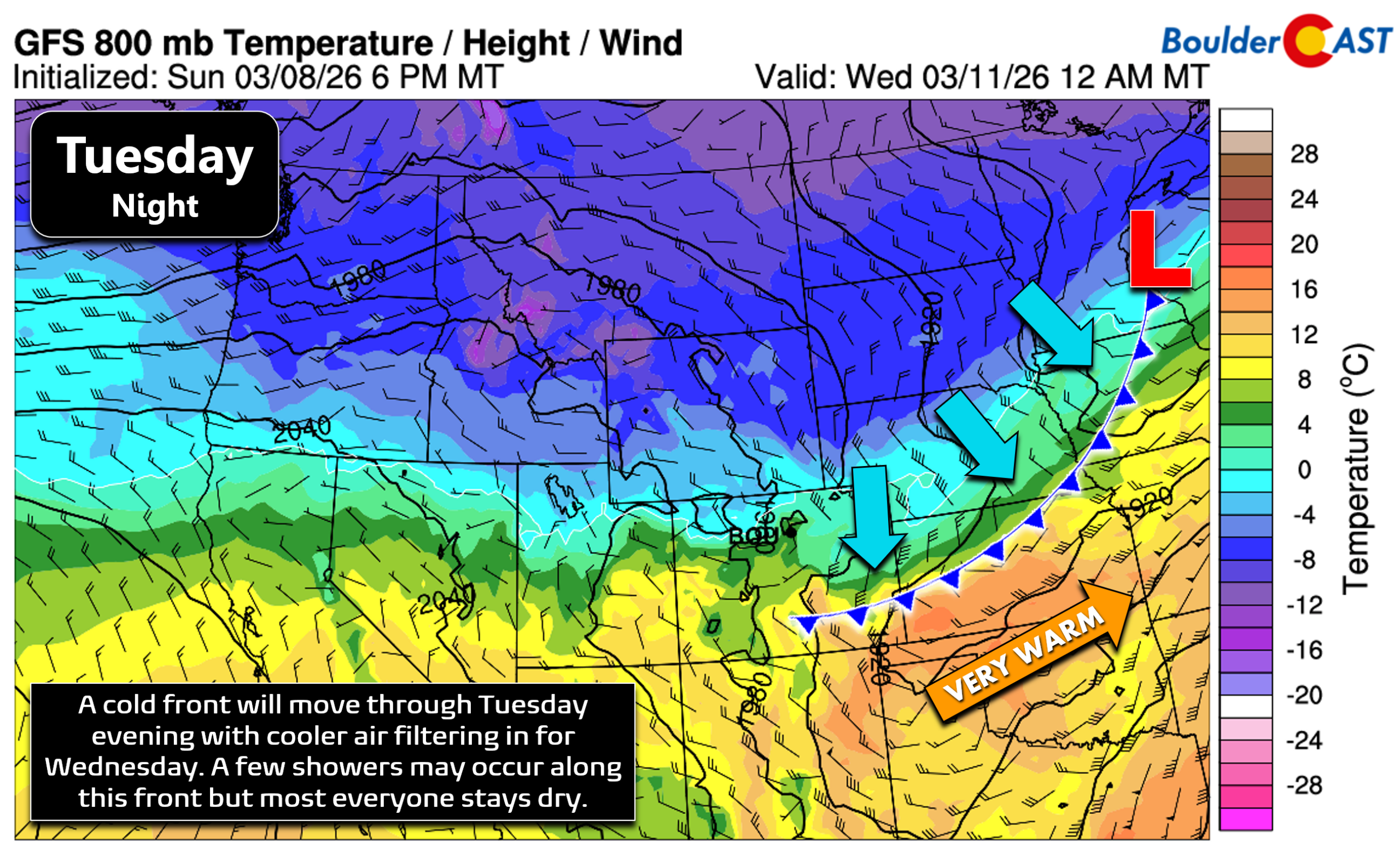
The northern Mountains — mainly north of I‑70 — will squeeze out a little light snow Tuesday evening into the night, but accumulations will be unimpressive: a trace to 2 inches, with the higher totals near the Wyoming border peaks.

Mountain snow potential from the mid-week cold frontal passage
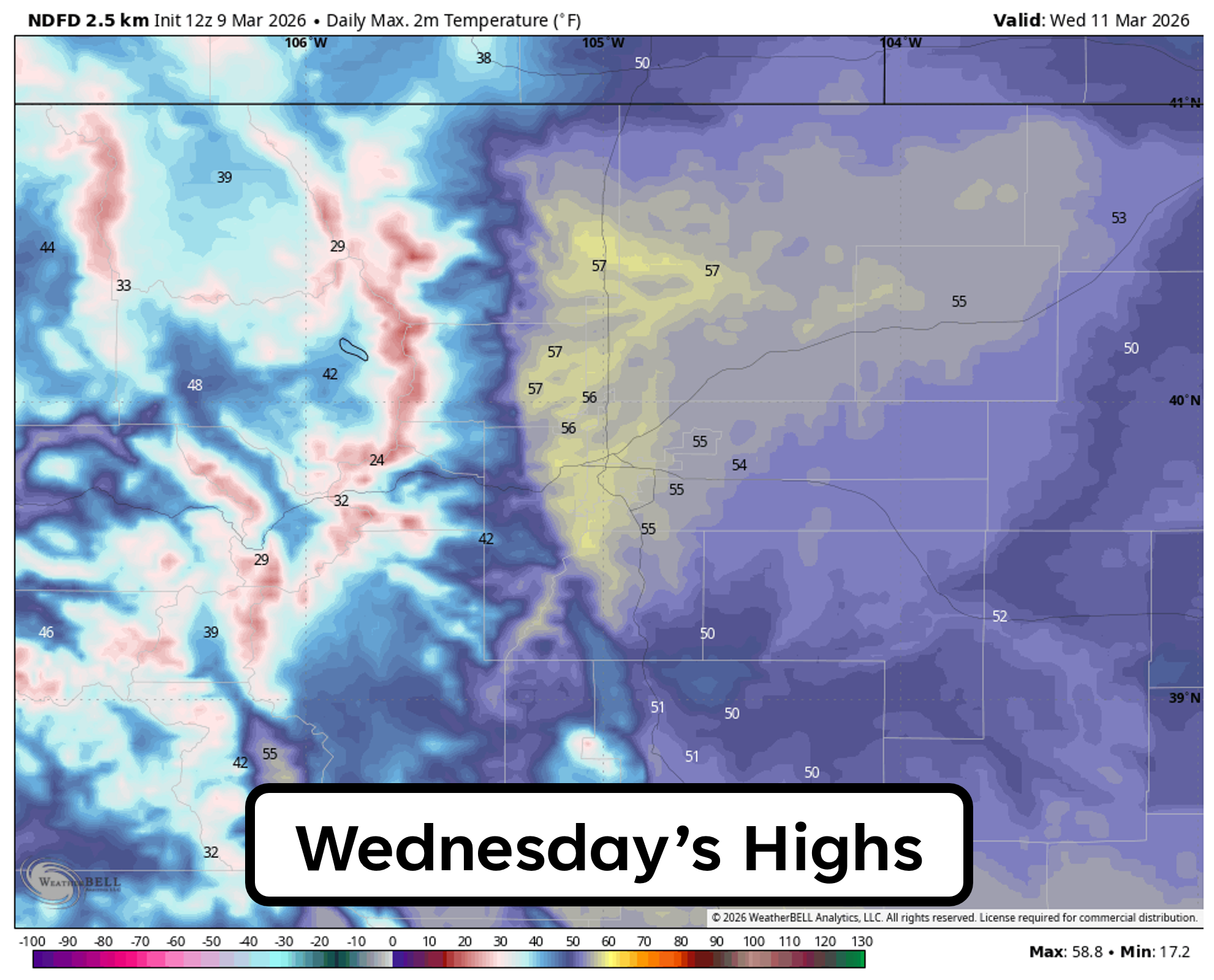
Behind the front, Wednesday cools noticeably, with highs falling back into the 50s. Even so, this “cooldown” still lands us near climatological norms — Boulder’s average mid‑March high sits in the upper 50s — yet another example of just how feeble this winter’s bite has been.
Fire danger ramps up late-week
A powerful jet core will nose into the Pacific Northwest later this week, and its southern fringe will dip into northern Colorado at times. This setup will increase west‑northwest flow by Thursday, reigniting downslope winds and sending temperatures soaring once again. Highs on Thursday will reach the upper 60s, with low 70s expected for Friday. Skies will be populated by splotchy wave cloud activity both days.
Late-week 250 mb jet level wind forecast from the Euro model showing a strong jet edging into the PNW and northern Rockies.
Persistent winds will become the headline late in the week and into the weekend. Gusts of 30+ MPH are likely Thursday and Friday, with even stronger winds possible Saturday ahead of another dry cold front. Humidity will be the deciding factor for fire danger, but current signals strongly suggest Red Flag conditions will be on the table for at least a couple days between Thursday and Sunday.
Overall, the main storyline this week will be the warmth and the wind, with a subplot of fire danger brewing late in the week.
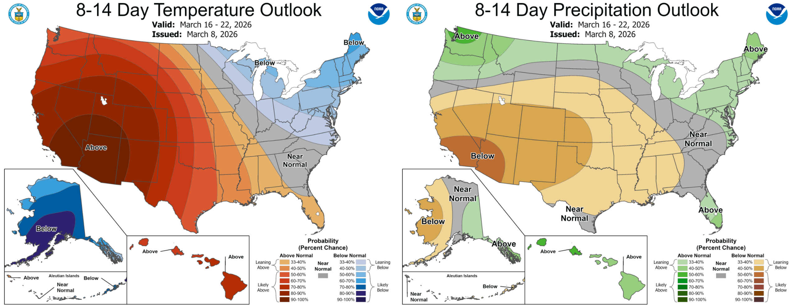
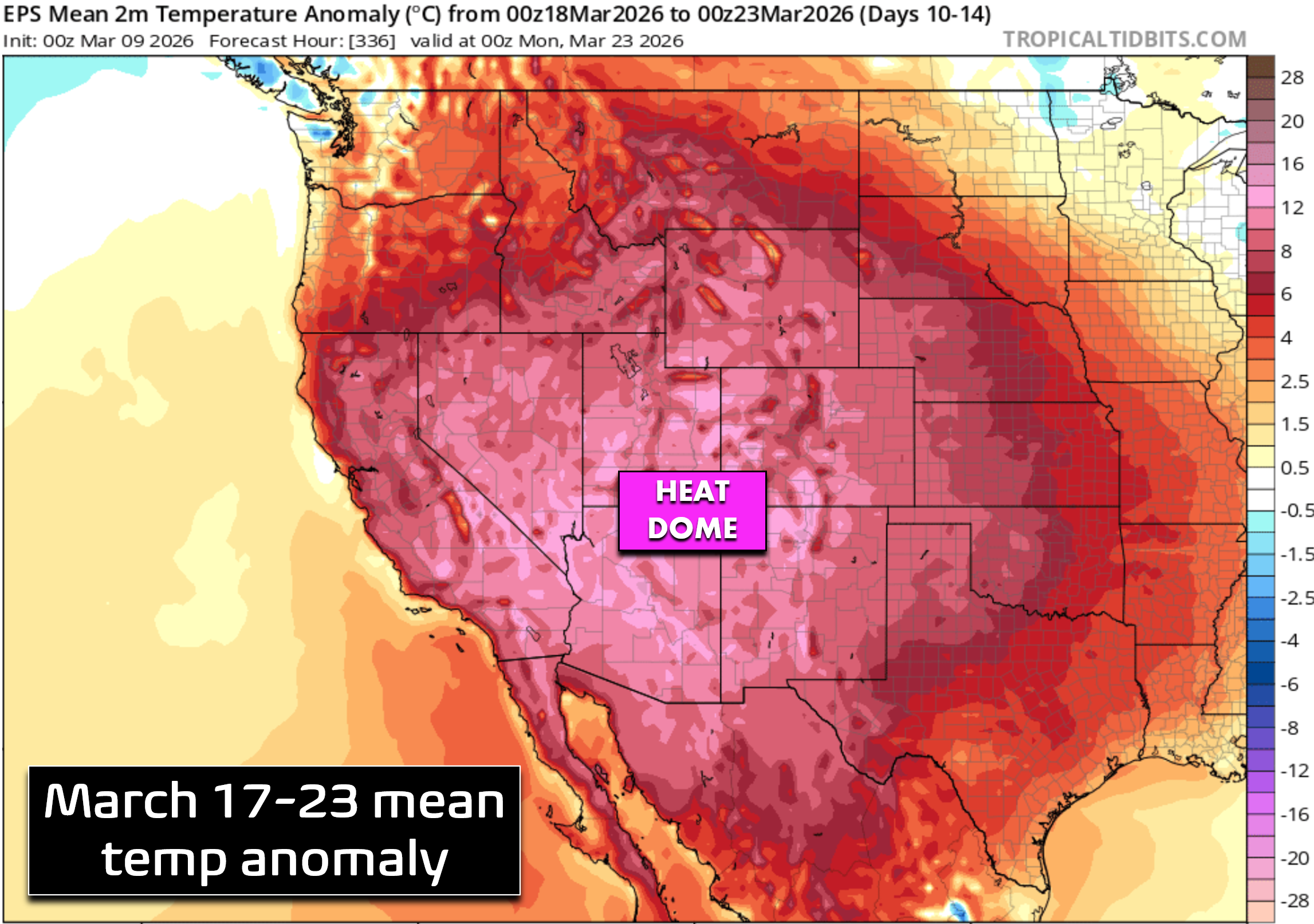
Next week: An exceptional heatwave looms
The upcoming weekend brings yet another cold front brushing northern Colorado. Current timing favors a Saturday evening to Sunday morning passage. A few rain or snow showers may accompany the front, but nothing meaningful is expected for the lower elevations. The northern Mountains will once again pick up some snow (perhaps several inches). Saturday looks very warm — likely well into the 70s — before a decent cooldown Sunday behind the front.
Beyond that, next week continues the theme we’ve been hammering all winter: unseasonable warmth across the West as a remarkably strong and concentric ridge re‑establishes itself over the Desert Southwest and Four Corners region.

European ensemble mean 500mb height anomaly forecast for NEXT week showing an intense ridge developing over the Southwest
This ridge is projected to be stronger and closer to Colorado than anything we’ve seen in the last several months. Under this developing heat dome, record highs will be challenged for days on end across most of the Southwest, and Boulder and Denver will flirt with — or exceed — 80° on multiple days, while the Deserts soar above 100°.
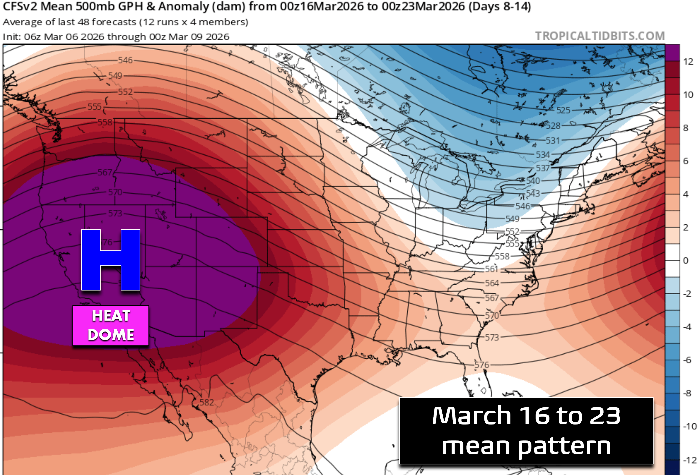
Unsurprisingly, dry weather will accompany the heat next week. With clear skies, such anomalous warmth more typical in early summer, and the increasingly potent March sun, our Mountain snowpack will almost certainly begin an early decline — exactly what we didn’t need given our ongoing drought and significantly lagging snowpack numbers.
This heatwave may be the final nail in the coffin for any hope of snowpack recovery this season in Colorado’s Rockies and elsewhere across the West…
Bottom Line
There’s no use getting depressed about our current situation or the one developing next week when summer-like temperatures invade the area before winter has officially ended. That’s the cards Mother Nature has dealt for Colorado and we can’t change that. Enjoy the nice weather in the days (and weeks ahead), but keep an eye on the bigger picture. The exceptional warmth, the nagging wind, and the extreme dryness are all signals that the Front Range is heading into a critical stretch, despite our recent dump of moisture, with little sign of anything changing over the next two to three weeks.
Forecast Specifics:
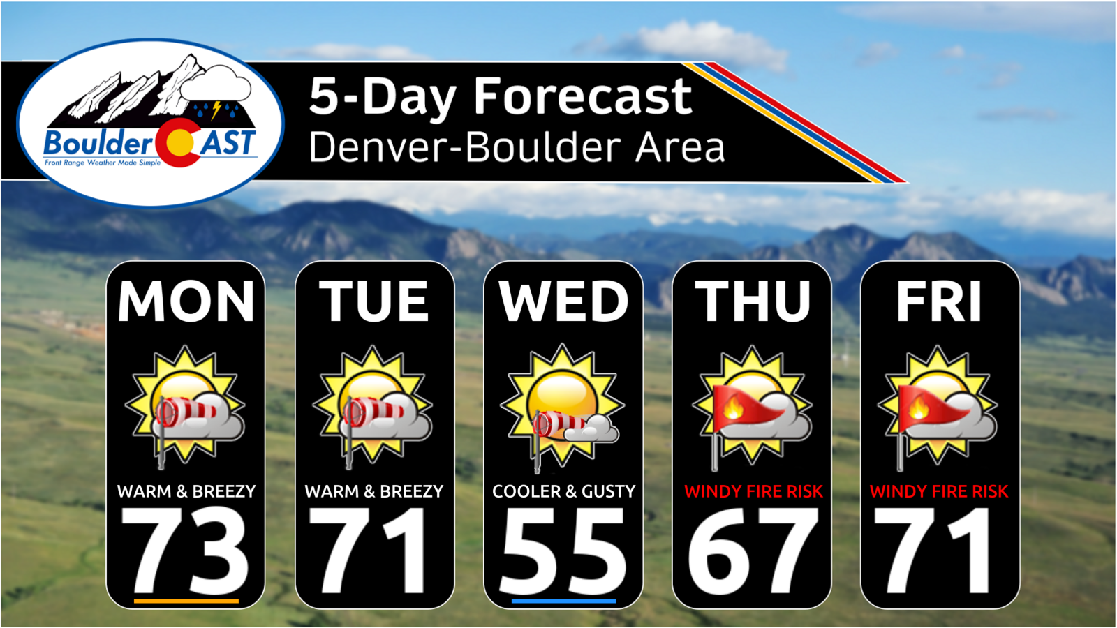
Monday: Partly cloudy, very warm and breezy. Highs in the middle 70s on the Plains with lower 60s in the Foothills. Winds during the day will gust up to 25 MPH.
Tuesday: Partly cloudy, warm and breezy again. Highs a touch cooler in the lower 70s on the Plains with upper 50s in the Foothills. Winds during the day will gust up to 25 MPH. A cold front arrives around sunset with no real impacts other than a brief surge of northerly winds.
Wednesday: Cooler and gusty behind the cold front with highs in the middle 50s on the Plains and middle 40s in the Foothills. Winds may gust over 20 MPH during the day.
Thursday: Warming back up with windy conditions and critical fire danger across the area. Highs in the upper 60s on the Plains with middle 50s in the Foothills.
Friday: Continued warm and gusty conditions with near-critical fire danger. Temperatures top out in the lower to middle 70s on the Plains with near 60° in the Foothills.
Weekend: Saturday will be warm and windy with likely very critical fire danger and highs in the 70s. Sunday is favored to be cooler behind a front in the 50s or so.
DISCLAIMER: This weekly outlook forecast is created Monday morning and covers the entire upcoming week. Accuracy will decrease as the week progresses as this post is NOT updated. To receive daily updated forecasts from our team, among many other perks, subscribe to BoulderCAST Premium.
Go Premium, get all the perks.
Daily Forecast Updates
Get our daily forecast discussion every morning delivered to your inbox.
All Our Model Data
Access to all our Colorado-centric high-resolution weather model graphics. Seriously — every one!
Ski & Hiking Forecasts
6-day forecasts for all the Colorado ski resorts, plus more than 120 hiking trails, including every 14er.
Smoke Forecasts
Wildfire smoke concentration predictions up to 72 hours into the future.
Exclusive Content
Weekend outlooks every Thursday, bonus storm updates, historical data and much more!
No Advertisements
Enjoy ad-free viewing on the entire site.
Enjoy our content? Give it a share!


Didn’t you once comment that when the dewpoint in Tucson stays at 43 degrees for 2 days in a row, it could mean torrential rain here?
Good memory Loretta. The Tucson dew point is something we watch to signal the start of monsoon season and it’s for 53°F daily average dew point for 3 straight days. That signals monsoon moisture has started to flow and within a week or two would make it into Colorado. That’s not a concern for now, but is something we’ll be watching for in late June and early July.
Some details from the 2023 monsoon season arrival: https://bouldercast.com/monsoon-moisture-is-coming-to-colorado-right-on-schedule-but-triple-digit-heat-stands-in-the-way/