The Front Range has managed to ink out a cool and wet summer so far, but that wasn’t at all due to the monsoon. We discuss what has been causing the cool/wet weather of late and look ahead to when monsoon season may actually commence in Colorado. Spoiler alert: it’s sooner than you might think, but there’s a bit of a catch!
MONSOON SPECIAL: Through the end of July, use promo code MONSOON to save 25% on BoulderCAST Premium. Redeem this time-limited offer HERE.
We discuss Boulder and Denver weather every single day on BoulderCAST Premium. Sign up today to get access to our daily forecast discussions every morning, complete six-day skiing and hiking forecasts powered by machine learning, access to all our Front Range specific weather models (including smoke forecasts), additional storm updates and much more!

Go Premium, get all the perks.
Daily Forecast Updates
Get our daily forecast discussion every morning delivered to your inbox.
All Our Model Data
Access to all our Colorado-centric high-resolution weather model graphics. Seriously — every one!
Ski & Hiking Forecasts
6-day forecasts for all the Colorado ski resorts, plus more than 120 hiking trails, including every 14er.
Smoke Forecasts
Wildfire smoke concentration predictions up to 72 hours into the future.
Exclusive Content
Weekend outlooks every Thursday, bonus storm updates, historical data and much more!
No Advertisements
Enjoy ad-free viewing on the entire site.
So wet lately, but it’s not the monsoon
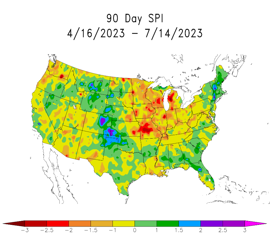
Colorado has been exceptionally wet the last few months with the eastern half of the state leading the nation in some precipitation categories. The map below shows the observed Standardized Precipitation Index (SPI) for the three-month period ending in the middle of July 2023. SPI is useful to compare precipitation as it relates to “average” over regions with vastly different climates. Notice the purple bullseye right over the Front Range! Much of our area has seen 12″ of rainfall in the last 90 days, more than double the usual for the period. Here in Boulder we’ve recorded back-to-back months with 5 inches of precipitation for the first time since 1995, including top 11 finishes all-time in both May and June.
Thanks to this deluge of moisture drought has been eradicated from our entire state, including the stubborn southeast corner for which all hope had almost been lost just a few months ago!
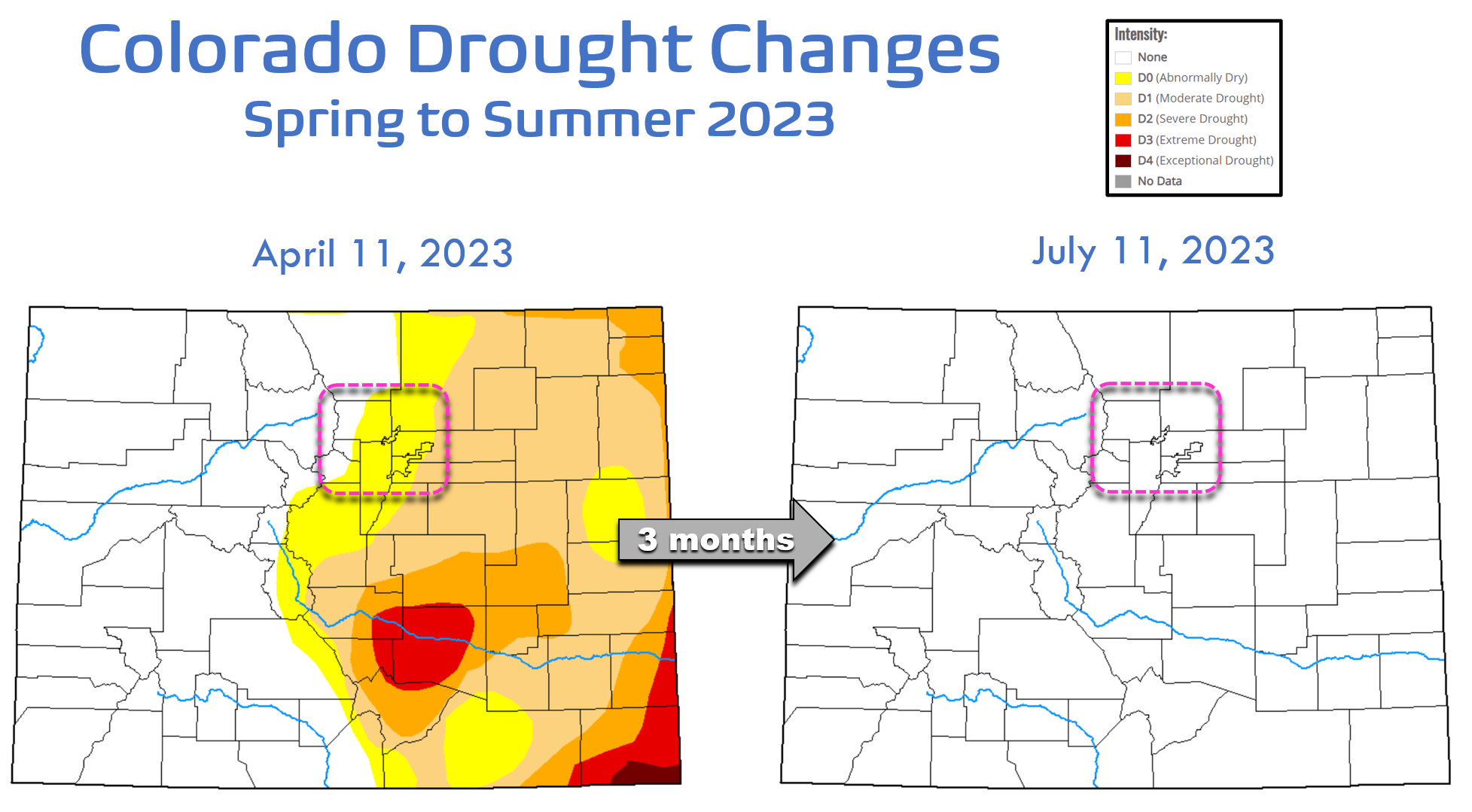
In fact, this is only the third time since 2000 that the entire state of Colorado is free from any drought classifications! Our state has definitely soaked up the rain (and mountain snow) well with native vegetation and our lawns as green as ever.

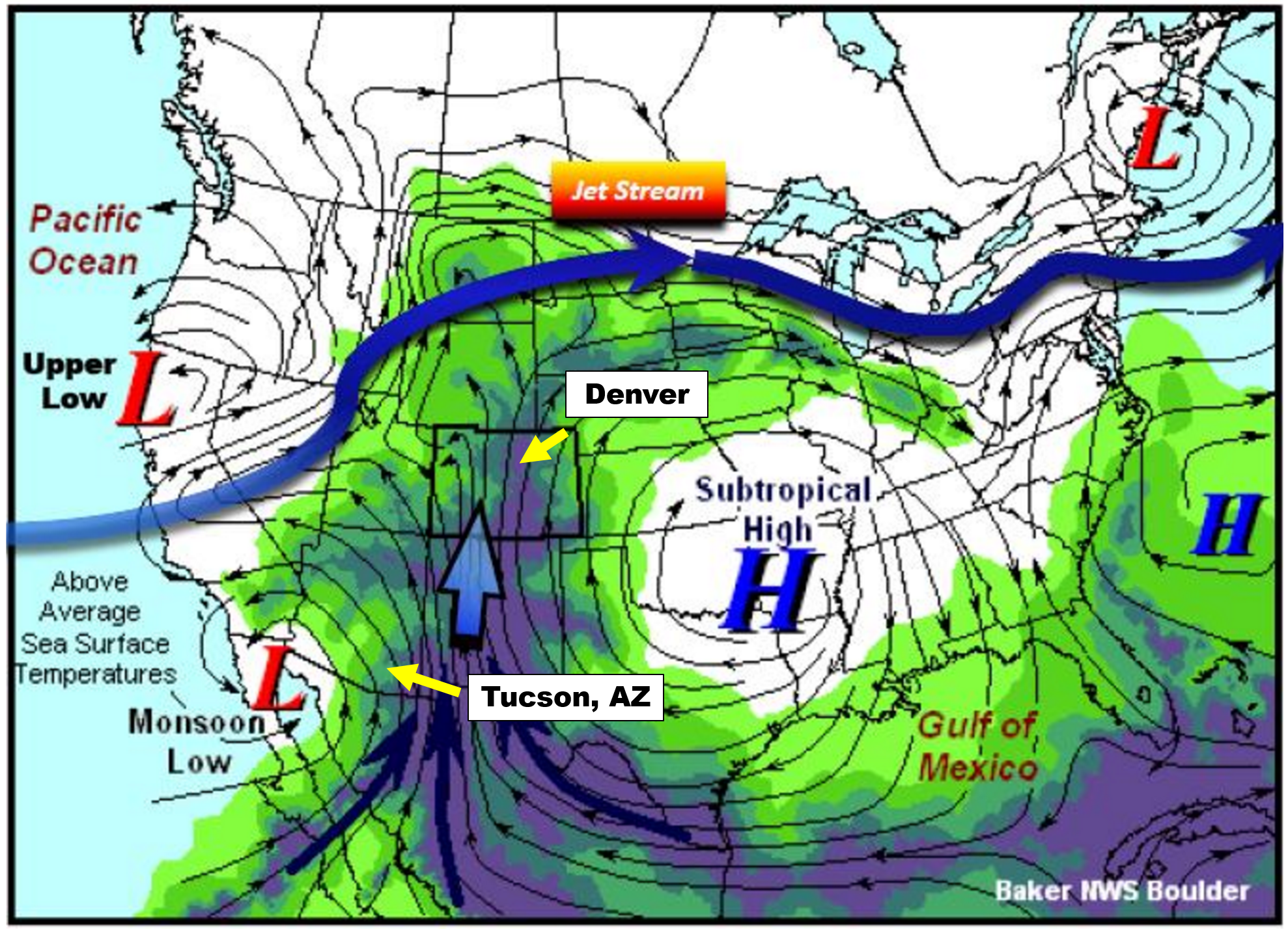
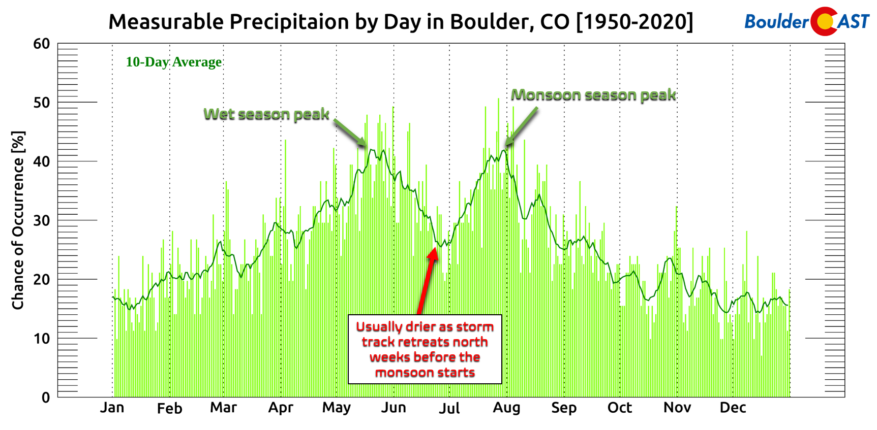
There’s no doubt it has been soggy these last few weeks and months, but ironically none of what has transpired thus far has been related to the monsoon! How can that be you ask? Well, the North American Monsoon is defined by a very specific type of pattern that develops across the southwestern United States. The diagram below shows the typical set-up which comes together to produce a seasonal wind shift that brings soaking rains to Colorado and much of the Four Corners region each summer. A “monsoon” low pressure in southern California often teams up with high pressure in the southeastern United States to funnel relatively large quantities of low and mid-level moisture northward into the Desert Southwest. This moisture is key to forming the widespread monsoon thunderstorms that are a staple of Colorado’s summer.
This monsoon pattern hasn’t gotten established yet this year so we cannot blame this wet stretch on the monsoon. The copious amounts of rainfall we’ve seen so far have instead been fueled by a lingering mid-latitude storm track and polar jet stream which typically would both have already retreated northward into Canada around mid to late June. The period from approximately June 10th to July 10th is usually somewhat drier in the Front Range — highlighted below — a result of the storm track shifting northward many weeks ahead of the monsoon’s arrival. This year Mother Nature just never let up keeping our weather interesting with surges of Gulf of Mexico moisture fueling storms and upslope rains, frequent troughs bringing chilly temperatures and at times we’ve seen prime conditions coming together for bouts of severe weather. This has certainly been on of the most active severe weather seasons we can remember for eastern Colorado, even if it did start a tad late. SO. MUCH. HAIL!
Here it comes!
For those that are looking forward to monsoon season kicking off — we bring good news! Just the past few days we are starting to see the storm track nudge back northward towards Canada and the first signs of the subtropical monsoon moisture flowing northward into the Southwest!
One way that we can track the arrival of the North American Monsoon is to monitor surface dew points in southern Arizona. Cities like Tucson (see location above) are much closer to the source of the moisture than we are here in Denver. The moisture more-or-less has to pass through Tucson as it moves northward into the United States. Tucson is also a pivot-point for the moisture plume itself. Think of Tucson as the “faucet”, with a “hose” of moisture wandering northward. Sometimes the hose if over Nevada, other times it meanders over Utah, and Colorado as well. While our monsoon here in Denver and Boulder is sporadic throughout July and August, the faucet is nearly continuous for Tucson. For this reason, Tucson actually sees more monsoon rainfall than Denver on average, and has a more predictable and consistent monsoon climatology.
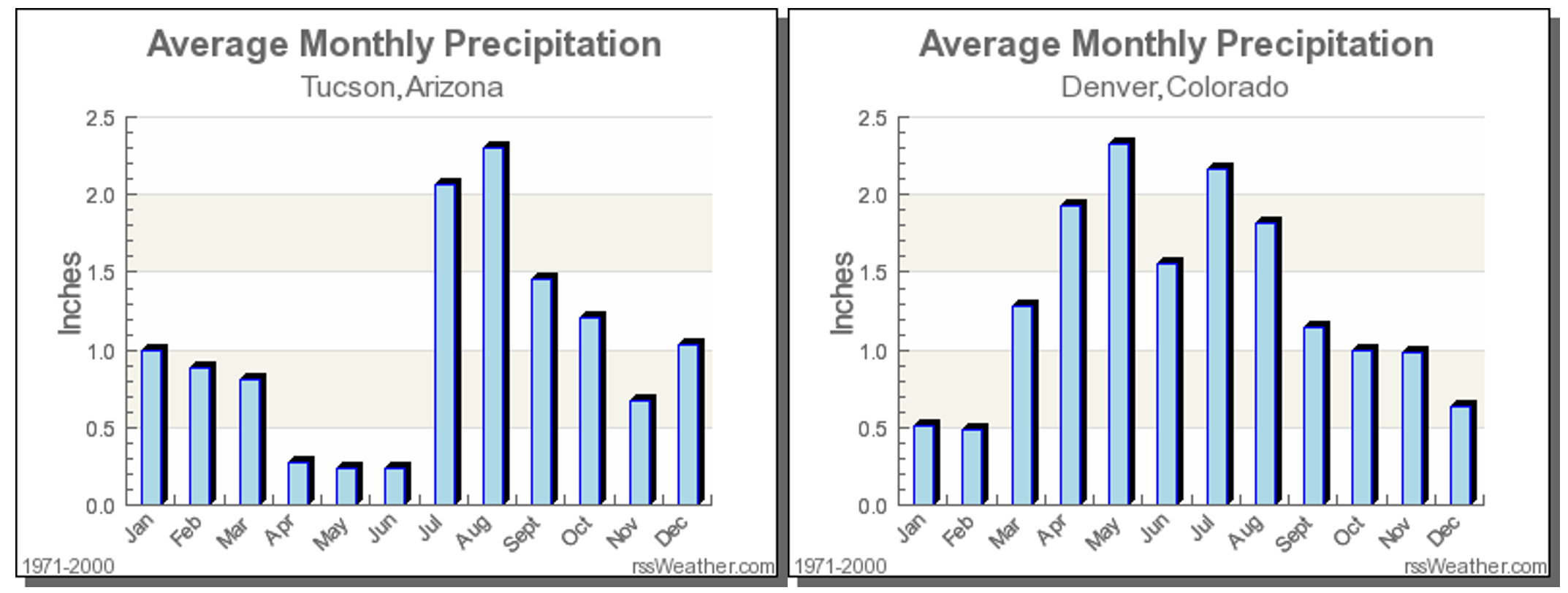
It is largely agreed upon that monsoon season’s official start is when the average daily dew point in Tucson is at least 54 degrees for three consecutive days. Seriously, this is a real thing that is closely monitored by meteorologists and residents of that area. We can’t blame them…July’s average rainfall exceeds the total for March, April, May and June COMBINED in Tucson (above plot on the left). The monsoon is a much bigger reprieve for them than it is for us, especially considering the edge it can take off of those 110°F afternoons that frequently occur in the Desert.
The graph below shows the daily average dew point values at Tucson Airport so far this summer. The red line is the actual data from 2023. The gray line is climatology and the green line is the coveted 54°F threshold for the monsoon. As you can see from the graph, up until July 9th nearly every single day had seen well below normal dew points in Tucson, but that changed in a hurry this past week with a surge of moisture pushing into southern Arizona. The official start of monsoon season quickly followed on July 11th, the third consecutive day with values above 54°F in Tucson. This start date is actually right on schedule with the climatological normal — though the extremely dry lead up was anything but!

After things get going in Tucson, it typically takes a solid week or more for the monsoon moisture to show up in our area — and that is exactly what model ensembles are showing for the extended forecast. Following an early week scorching heat wave, monsoonal moisture will flow into Colorado around Tuesday or Wednesday bringing a chance of late-day thunderstorms and a slight reprieve from the baking heat. In the GFS ensemble mean moisture anomaly forecast animation below, notice how the moisture flows up from Arizona into California/Nevada before circulating east towards Colorado.
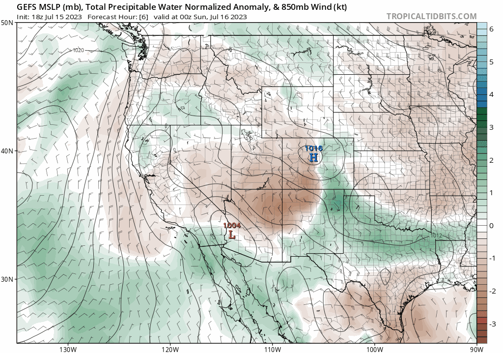
This trajectory is following the clockwise flow of a dominant ridge of high pressure the will set up over the Arizona-New Mexico border next week. This is far from an ideal monsoonal setup for us as plenty of the moisture will rain out over the rest of the West before even reaching the Front Range, but it will indeed be enough to officially count as the start of monsoon season here! In an ideal world, this high pressure would be further east in Texas with the faucet aimed directly at Colorado!

Remember, Colorado’s monsoon thunderstorms form via daytime solar heating — with the clouds and thunderheads popping over the terrain first due to their sloped mountain surfaces heating up quicker. As the storm clouds grow in the High Country, the prevailing winds from the west push the storms eastward across the Denver Metro area where outflows can help form subsequent new thunderstorms. Each evening, all of the activity generally dies out shortly after sunset. This diurnal cycle rinses and repeats all summer long, with the ever-changing influx of subtropical moisture content determining the exact location and coverage of the storms on any given day.
After the kind of heat Mother Nature will throw our way in the coming days, we expect to hear more than a few celebratory cheers when the pipeline of monsoon moisture arrives around the middle of the week!
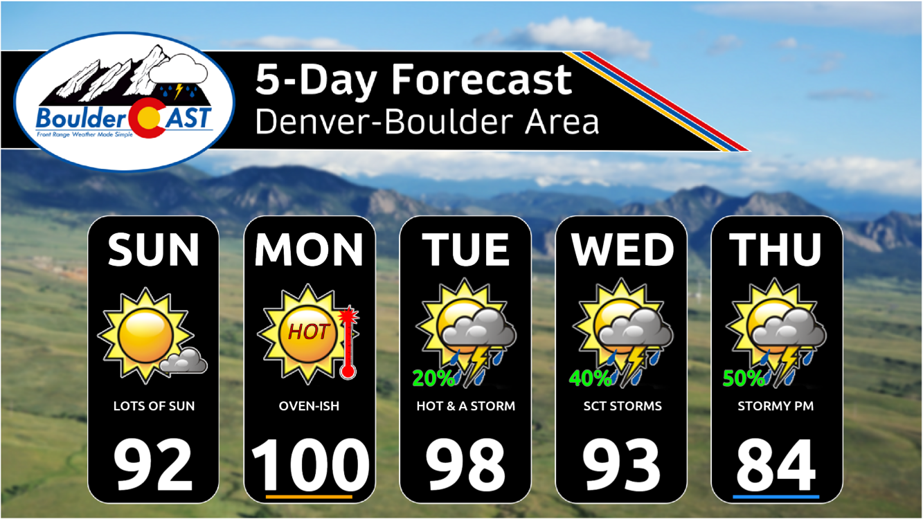
Boulder’s record high temperature on Monday July 17th is 98°F. That could be broken.
MONSOON SPECIAL: Through the end of July, use promo code MONSOON to save 25% on BoulderCAST Premium. Redeem this time-limited offer HERE.
Go Premium, get all the perks.
Daily Forecast Updates
Get our daily forecast discussion every morning delivered to your inbox.
All Our Model Data
Access to all our Colorado-centric high-resolution weather model graphics. Seriously — every one!
Ski & Hiking Forecasts
6-day forecasts for all the Colorado ski resorts, plus more than 120 hiking trails, including every 14er.
Smoke Forecasts
Wildfire smoke concentration predictions up to 72 hours into the future.
Exclusive Content
Weekend outlooks every Thursday, bonus storm updates, historical data and much more!
No Advertisements
Enjoy ad-free viewing on the entire site.
Get BoulderCAST updates delivered to your inbox:
Enjoy our content? Give it a share!


I just need one more week of hot dry weather for a road project.
No promises as one or two days this week will have good rain chances!